Snappit logo
Snappit
Get App
Generic illustration, not a photograph of this venueIllustration
ParkTohoku / Chubu, Japan

Bandai-Asahi National Park

Start at Urabandai Visitor Center, then let the ponds set the pace.

About

Start at Urabandai Visitor Center, then let the ponds set the pace. Bishamonnuma, the largest of the Goshikinuma ponds, makes a satisfying first stop: green-blue water, wooded banks and, when the clouds cooperate, Mount Bandai rising behind them. The visitor center helps turn that attractive view into a story you can follow on foot. Ask about the day’s trail conditions before choosing a short visit or the full pond walk.

Bandai-Asahi is much larger than this corner of Fukushima. The national park reaches across Yamagata, Fukushima and Niigata, taking in the Dewa Sanzan, Asahi and Iide mountains as well as the Bandai-Azuma area. This guide stays with the visitor center and Goshikinuma in Urabandai. Mountain ascents and the park’s distant sacred peaks deserve separate days and preparation.

Goshikinuma is a collective name for several dozen ponds, rather than a single lake or a set of exactly five. Their landscape took shape after Mount Bandai’s 1888 steam-driven eruption caused a massive collapse. Rock and debris blocked drainage channels, leaving water pooled between the deposits. These wooded ponds are not simply bowls left in old craters. The disaster transformed a lived-in landscape, and the peaceful scene today has a much more turbulent beginning.

The water is the real invitation to slow down. Compare Bishamonnuma with the milky blue of Aonuma or the more open view at Bentennuma. Akanuma’s reddish margins offer another clue to the chemistry beneath the surface. Mineral-rich water, fine particles and iron deposits help create the colours, while light, season and reflections change how they look. Rather than hunting for a particular shade from a photograph, notice the differences that are there on your day.

Look up from the ponds, too. The forest is a landscape of recovery, helped by planting led by Endo Genmu and others after the eruption. Red pines were important pioneers on the disturbed ground. Autumn shrubs add small flashes of colour, and the combination of water and woodland gives birds several different places to feed. A pair of binoculars and a little patience can add as much to the outing as reaching the next viewpoint.

For a compact visit, enjoy the center and the approach to Bishamonnuma, then return the same way. For more variety, the approximately 4-kilometre Goshikinuma Nature Trail links the eastern visitor-center side with the western Yanaginuma side. It has little overall height change, but exposed rocks, boardwalks, muddy patches and entrance steps make it a proper woodland walk. Plan the bus connection before setting off so that the final pond does not become the start of an unexpected walk back. Be ready to snap and learn! Get the Snappit app to identify any nature species you find here.

Bandai-Asahi became a national park on 5 September 1950. In Urabandai, the defining event was Mount Bandai’s 1888 steam-driven eruption and collapse, which blocked rivers, destroyed communities and created new lakes and ponds. The forest that followed owes part of its recovery to people: Endo Genmu invested in replanting the damaged land, using pioneer trees such as red pine. Urabandai Visitor Center opened in 2003 and reopened with renewed exhibitions in April 2025. Its role is a useful one for a first visit: connecting the scenery outside with the region’s geology, wildlife and history.


What to do here

Begin with the visitor center’s geology and nature displays and ask staff which sections are open. Take the paved approach to Bishamonnuma for a short outing, or, in suitable conditions, walk the full pond trail with transport arranged between its two ends. Along the way, compare the water colours, look for the mountain through gaps in the trees, and watch the woodland and waterbirds from the path.

Seasonal info

Snow can linger into spring, and thawing ground becomes muddy. Summer brings leafy shade, insects and wet-weather footing; carry water and rain protection. Autumn is good for combining pond colours with leaves and fruit, but colder weather and shorter days arrive quickly. Winter is a different outing: deep snow can hide both the path and signs. First-time winter visitors should choose a guided snowshoe trip with suitable equipment, rather than follow footprints into the woods.

Accessibility

The visitor center has designated accessible parking, a multipurpose toilet and free wheelchair loans. The approach to Bishamonnuma’s viewpoint is paved, but the eastern entrance climbs a slope; ask staff about gradients and the viewing position that suits you. The full trail includes uneven rock, gravel, boardwalks and steps at the western entrance. Do not plan it as a continuous step-free or stroller-friendly route. For specific access needs, call the center on 0241-32-2850 before travelling.

Don't miss

1

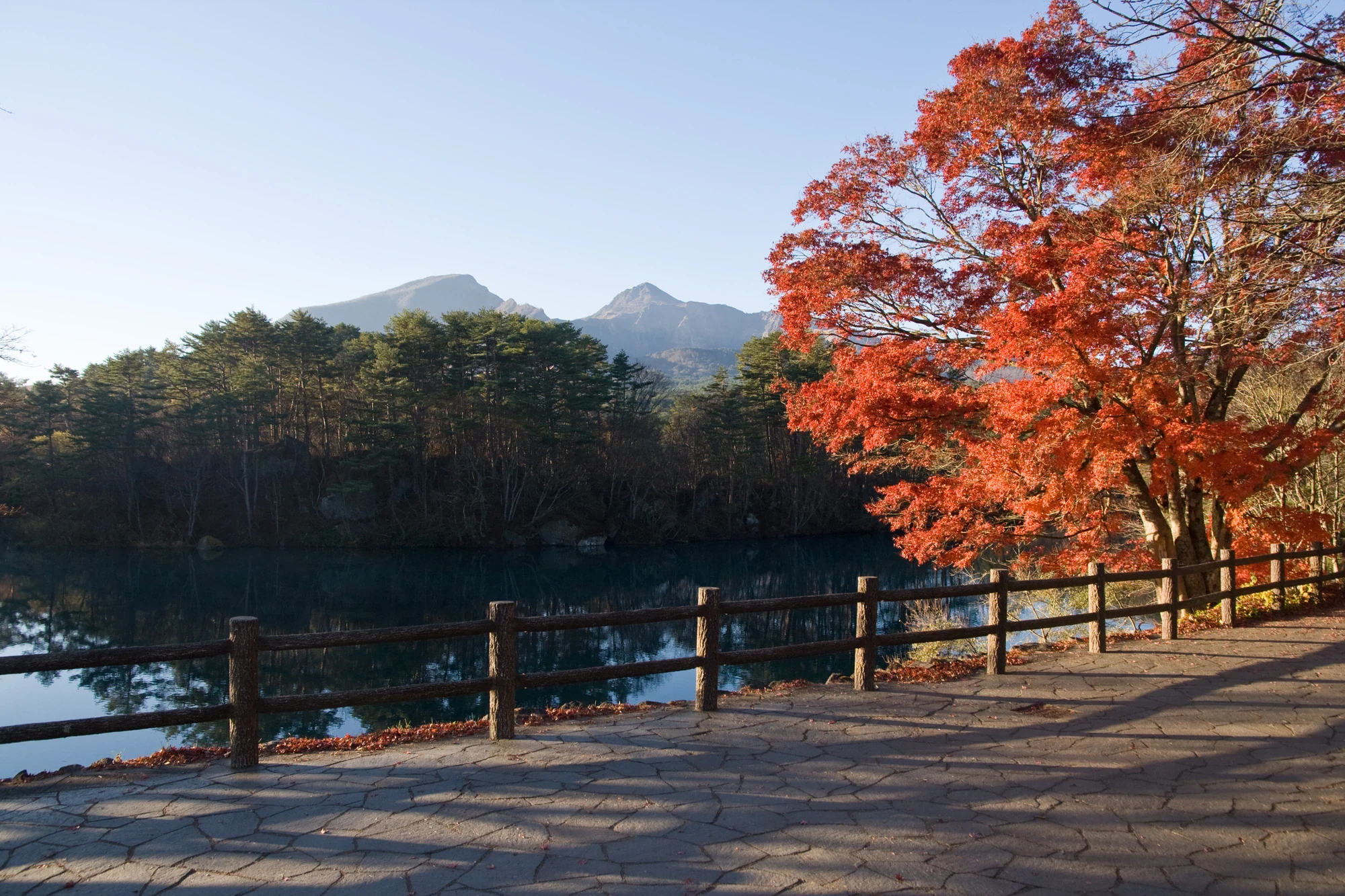
Bishamonnuma’s water and a weather-dependent view of Mount Bandai

2

Different blues and greens along the Goshikinuma pond trail

3

A close-up look at a forest recovering from volcanic disturbance

4

The visitor center’s nature displays and free indoor quiz

Red-orange leaves overhang a fenced stone path beside a dark reflective pond, with forest and the craggy profile of Mount Bandai beyond.

Mount Bandai appears beyond Bishamon Pond in the Goshikinuma lake group, with autumn foliage beside the waterside path. Photographed on 6 November 2015.

Mt.Bandai from Goshikinuma 01.jpg — Σ64, CC BY 3.0 (https://creativecommons.org/licenses/by/3.0/). Source: https://commons.wikimedia.org/wiki/File:Mt.Bandai_from_Goshikinuma_01.jpg. Resized and recompressed as WebP; no crop or retouching. · Creative Commons

Walks and routes

Visitor center and Bishamonnuma, returning the same way

Explore the center first, then follow the signed approach to the Bishamonnuma viewpoint. Take time over the water and mountain view, and return before anyone becomes tired. The short outing is worthwhile without continuing into the woodland trail.

The approach is paved but climbs a slope. Ask staff whether the gradient, surface and viewing position suit your wheelchair, stroller or walking needs.

Visitor center and Bishamonnuma, returning the same way

Goshikinuma Nature Trail, one way

Walk between the visitor-center side and Yanaginuma at the western end. Choose the direction around your bus connection; if arriving by car, taking the bus before walking can remove the pressure of catching one at the end. Keep to the signed main trail and pause where the path allows others to pass.

Uneven rock and gravel, boardwalks, mud after rain, an uphill eastern entrance and western entrance steps. Not a continuous step-free route.

Goshikinuma Nature Trail, one way

Western ponds, returning towards Yanaginuma

For a shorter woodland option from the western end, follow the marked trail past the blue-water ponds towards the Bentennuma viewpoint and return the same way. Check the restriction boundary with staff and signs before starting; a shorter walk still needs bear precautions.

The western entrance has stairs and the walk uses the same uneven natural trail as the through route.

Western ponds, returning towards Yanaginuma

Start at the visitor center, check current notices and browse the displays.

Walk to the Bishamonnuma viewpoint only if the approach suits your group and conditions.

Return for the indoor quiz or another look at the exhibits before leaving.

Begin at the visitor center, use the toilets and check the trail’s permitted hours.

If using a car at the eastern end, take your prechecked bus to the western entrance before walking back.

Follow the signed trail through the pond group, leaving room for photo and nature stops.

Finish the restricted section by 16:00 and return any rented bear bell by its deadline.

Things to try

Make a pond-colour notebook

At each viewpoint, choose a colour word, sketch the water and add a note about sun, cloud or reflections. Compare your notes at the end. Stay on the path and leave the water and shore undisturbed.

Find the landscape’s before-and-after story

Use the visitor-center displays to picture the 1888 collapse, then look for contrasts between rock, pond and forest outside. Ask how red pines helped the woodland return.

Try the center’s indoor quiz

If children need a change of pace, ask for the free quiz and use the displays to find the answers. Check with staff which activities are running that day.

Watch waterbirds and woodland birds

Bring binoculars and look from the established path and viewing areas. Compare a bird swimming on open water with one moving through branches. Keep your distance, do not feed wildlife and continue to follow local bear precautions while walking.

Choose a guided winter outing

In snow season, go with a local guide who can choose a suitable route and explain winter tracks and pond scenery. Confirm the departure, equipment, age limits and current trail restrictions before booking.

Keep the visit indoors

Spend time with the visitor-center displays and free quiz. If the weather improves, ask whether the short Bishamonnuma approach is suitable. In heavy rain, strong wind or poor footing, skip the woodland trail.

Wildlife and habitats

Linden viburnum

Look for a deciduous shrub with broad leaves and clusters of red autumn fruit. This is gamazumi, a small splash of colour among the Goshikinuma woodland plants. Leave the fruit for wildlife and avoid touching unfamiliar plants.

Long-tailed tit

Watch the branches around Bishamonnuma for a very small pale bird with a conspicuously long tail. Binoculars help you follow its movements without leaving the path or crowding the birds.

Mallard

Use binoculars to examine ducks on the pond. A male mallard’s yellowish bill is one clue, but females and hybrids need more care. Photograph what you can see and compare it with a field guide later.

Eurasian coot

Look for a dark swimming bird with a contrasting white bill and forehead. Scan Bishamonnuma from the established viewing areas, keep back from the water and watch through binoculars.

Asiatic black bear: give it space

Bears live in this landscape. Do not search for them, follow tracks or approach one for a photograph. Follow the visitor center’s precautions and current trail restrictions; if you encounter a bear, stay calm and retreat slowly without running or shouting.

Stories and discoveries

The name is about a palette

Goshikinuma describes a group of ponds with varied colours. Counting to five will not tell you how many ponds belong to it.

Blocked water, rather than crater bowls

The 1888 collapse spread debris across drainage channels. Water collected behind those natural barriers, making the pond-filled landscape you walk through today.

Colour has a physical explanation

Fine particles in the water scatter light, while iron-rich deposits contribute reddish tones. A blue pond is a small lesson in both geology and light.

The woodland has a human chapter

Planting helped restore trees after the eruption. The red pines around the ponds are part of a story of recovery and changing vegetation, rather than an untouched forest frozen in time.

Two different Goshikinuma destinations

The Azuma mountains also have a lake named Goshikinuma, known as the Witch’s Eye. It is a separate mountain destination from this Urabandai pond group.

When to visit

spring

Expect a later spring than in the lowlands. Check remaining snow and thaw-softened ground before committing to the full trail.

summer

Take water, insect protection and rainwear. Leafy views change as you move between enclosed woodland and open ponds.

autumn

Look at the woodland as well as the water: leaves and berry-bearing shrubs bring extra colour. Check recent foliage reports and road conditions instead of relying on one fixed peak date.

winter

Snow can conceal the path and signs. Choose a guided snowshoe outing if unfamiliar with the area; ordinary summer walking times and access assumptions do not apply.

Getting there and practical advice

Urabandai Visitor Center

Free-entry nature and geology displays, a staffed information desk and an indoor quiz. Open 09:00–17:00 April–November and 09:00–16:00 December–March. Normally closed Tuesdays, the day after a Tuesday public holiday, and around New Year; check annual holiday exceptions.

Toilets and preparation

The center lists an outdoor public toilet, including a multipurpose accessible toilet, for 24-hour use. Use facilities before the through walk; there are no toilets or vending machines on the pond trail.

Bear-bell loans

The listed 2026 scheme is planned through the end of November. Loans run 09:00–15:00 and bells must be returned by 16:00. The upfront payment is ¥1,200, including a ¥1,000 deposit returned with the undamaged bell. Confirm availability and return arrangements at the desk.

Arrive through Inawashiro

From Koriyama, use the JR Banetsu West Line to Inawashiro, then the current Aizu-area bus service towards Urabandai. Use Goshikinuma-iriguchi for the visitor-center/eastern end, or Urabandai Kogen-eki for the western end. Kogen-eki is a bus-stop name here, not a railway station.

Link the trail’s two ends

Use the operator’s timetable revised 1 October 2026, choosing the weekday or weekend/public-holiday page and checking seasonal notes. Confirm which western boarding point your bus uses. Plan the connection before walking, and keep the 16:00 trail restriction separate from the time of your bus.

Park at one end and plan the return

Public parking serves both ends: the visitor center/tourism-plaza side in the east and the Bussankan side in the west. If driving in late autumn or winter, check your approach roads: scenic mountain roads can close for snow and ice even before their planned winter closure.

Visitor-center facilities

The center has designated accessible parking, a multipurpose toilet and free wheelchair loans. Ask ahead about your intended entrance and indoor route.

Bishamonnuma approach

The center-to-viewpoint approach is paved, with an uphill eastern entrance. Ask staff about the slope, surface and viewing access that suit your needs.

Full trail and western entrance

Expect uneven rocks, gravel and boardwalks, with steps at the western entrance. Choose a shorter suitable visit if these are barriers for you.

Sources and useful links

Wildlife you might spot

5

Each card links to a full Explore page with photos, traits, and fun facts.

Snap map for this place

Start with the big picture, then zoom in to explore individual wildlife observations around this place.

Loading map…

Good to know before you go

Check trail notices before walking. As checked on 16 October 2026, the section between the Bishamonnuma and Bentennuma viewing platforms is restricted to 09:00–16:00. Be out of that section by 16:00 and obey any newer signs or staff instructions.

This is bear habitat. Walk with others, make your presence audible and follow local bear precautions. If you meet a bear, stay calm and move away slowly; do not run or shout. Never approach a cub. A bell is a precaution, not a guarantee.

Use the toilets and fill your day bag before the full walk: there are no toilets or vending machines along the trail. Bring drinking water, snacks, a warm layer and rain protection, and carry all rubbish out.

Wear shoes with good grip. Wet rocks and boardwalks can be slippery, and puddles or mud make the walk slower. Turn back or keep to the short visit if footing or weather is poor.

Check the current bus timetable for your actual day and stop. Goshikinuma-iriguchi serves the eastern end; Urabandai Kogen-eki serves the western end. Taking the bus first and walking back towards your car can make the day simpler.

Stay on the marked route. This is a specially protected part of the national park: leave plants, animals, stones and soil where they are. Enjoy berries and flowers by looking, not collecting or tasting.

Mount Bandai remains an active volcano. JMA listed Alert Level 1 on 16 October 2026; check again before visiting, especially before adding a mountain hike. Keep out of restricted crater and volcanic-gas areas and follow local instructions.

The center normally opens 09

00–17:00 in April–November and 09:00–16:00 in December–March. It closes on Tuesdays, or the following day when Tuesday is a public holiday, and around New Year; holiday-period exceptions vary. Center hours do not extend the trail’s permitted hours.

Frequently asked questions

No. This visit concentrates on Urabandai Visitor Center and the Goshikinuma ponds in Fukushima. The Dewa Sanzan, Asahi and Iide ranges, and other volcanic areas, need their own travel and walking plans.
No. A visit to the center and Bishamonnuma works well on its own. The full trail is approximately 4 km one way, so walking it back again doubles that distance. Arrange a bus connection if you want to walk through just once.
There is little overall climbing, but the rough surface still needs care and the full distance can be tiring. Start with the short pond visit if you are unsure, keep children close by the water, and leave plenty of time for stops.
Ask the visitor center about the paved Bishamonnuma approach and its slope. Accessible facilities are listed at the center, but the complete pond trail has rough ground and western entrance steps. Choose a specific suitable section rather than assuming access throughout.
The ponds receive waters with different mineral content. Fine mineral particles scatter light, and deposits such as iron oxides contribute other colours. Weather, reflections and the season alter the result, so the same pond can look different on another visit.
Yes, with winter-specific planning. Snow can cover the route and hide signs, and footprints may lead somewhere else. For a first visit in snow, book a guided outing and check current conditions and equipment requirements.
The Goshikinuma pond group here is in Urabandai. The lake called the Witch’s Eye lies in the Azuma mountains and is a separate mountain outing. Check that your navigation destination is Urabandai Visitor Center or the correct pond-trail entrance.
Admission to the visitor center is free. Equipment rentals and separately offered activities can have their own fees; ask what is available that day.
The center admits assistance dogs but asks other pets to stay outside. The trail permits leashed pets, with waste removed, but local bear guidance recommends avoiding trail walks with pets because they can provoke wildlife. Consider another plan if you are travelling with a dog.

Recent snaps at this place

Recent snaps will appear here as new observations are added.

View all ›

Take the discovery with you

Exploring Bandai-Asahi National Park?

Identify the wildlife you spot, learn as you go, and keep a collection of the adventure.

  1. 1Spot it
  2. 2Snap it
  3. 3Keep the discovery