
Snappit logo
Snappit
Get App
Generic illustration, not a photograph of this venueIllustration
ParkKansai, Japan

Biwako Quasi-National Park

At Kaizu Osaki, the pleasure is in the meeting of water, rock and trees.

About

At Kaizu Osaki, the pleasure is in the meeting of water, rock and trees. The headland pushes into northern Lake Biwa, with Chikubushima visible offshore when the view is clear. In spring, flowering cherry trees follow the shore for roughly 4 km. At other times, come for the shape of the coast and the changing colour of the lake and save the blossom experience for spring.

This is one small corner of Biwako Quasi-National Park. The protected landscape includes the lake, surrounding mountains and parts of the Uji River corridor, extending across Shiga and Kyoto prefectures. Trying to see it all in a day would turn an unhurried lakeside visit into a transport exercise. Start instead at JR Makino Station and choose how much walking you want.

For a satisfying first visit, follow the tourism association’s approach via Lake Terrace to Ōsaki Namikiguchi, the western entrance to the cherry-lined stretch. The Kaizu Osaki lakeshore park is about 400 m farther on and makes a sensible turnaround. Walking there and back from the station comes to about 4.8 km; a local bus can shorten the approach. Leave room for looking across the water and stopping well clear of passing traffic.

The important catch is the road. Kaizu Osaki’s blossom corridor is shared with vehicles and bicycles, and sections are narrow. A spring one-way system still leaves traffic moving through it. Families should keep children close and be willing to turn around early if the available space feels uncomfortable. You do not need to complete the whole cherry-lined coast to enjoy this place. Turn your visit into a safari! Use the Snappit app to scan and log wildlife sightings here.

Biwako was designated on 24 July 1950, among Japan’s first quasi-national parks. The Eight Views of Lake Biwa were chosen in the same year; Kaizu Osaki’s rocky shore in dawn mist is one of them. The cherry avenue is also a cared-for landscape: the local Utsukushii Makino Sakura-mori association was formed in 1997 to help protect it, and conservation work continues today.

What to do here

Take a short out-and-back to the lakeshore park, compare the rock-edged headland with the broad water beyond, and pause for photographs only where you can stand clear of the road. In blossom season, a booked sightseeing cruise offers a different view of the trees; confirm its departure port and whether it lands at Kaizu Osaki.

Seasonal info

Spring brings heavy visitor traffic and date-specific road controls. The 2026 cherry cruises have finished, so use the operator’s next published season rather than old sailing dates. Summer calls for drinking water and sun protection; in winter, check for snow, ice and road restrictions before leaving Makino.

Accessibility

The shared-road sections make this a poor choice for anyone who needs a continuous protected, step-free route. Wheelchair and stroller users should ask Makino Station’s tourist office about the exact stretch and current conditions before committing. Cruise boarding also varies by vessel and port; arrange assistance with the operator in advance.

Don't miss

1

A rocky headland set against the open water of northern Lake Biwa

2

About 800 planted Somei-yoshino cherry trees along roughly 4 km of shore

3

A manageable first taste of the coast from Ōsaki Namikiguchi to the lakeshore park

4

A spring boat view of the blossom-lined peninsula, when seasonal sailings are operating

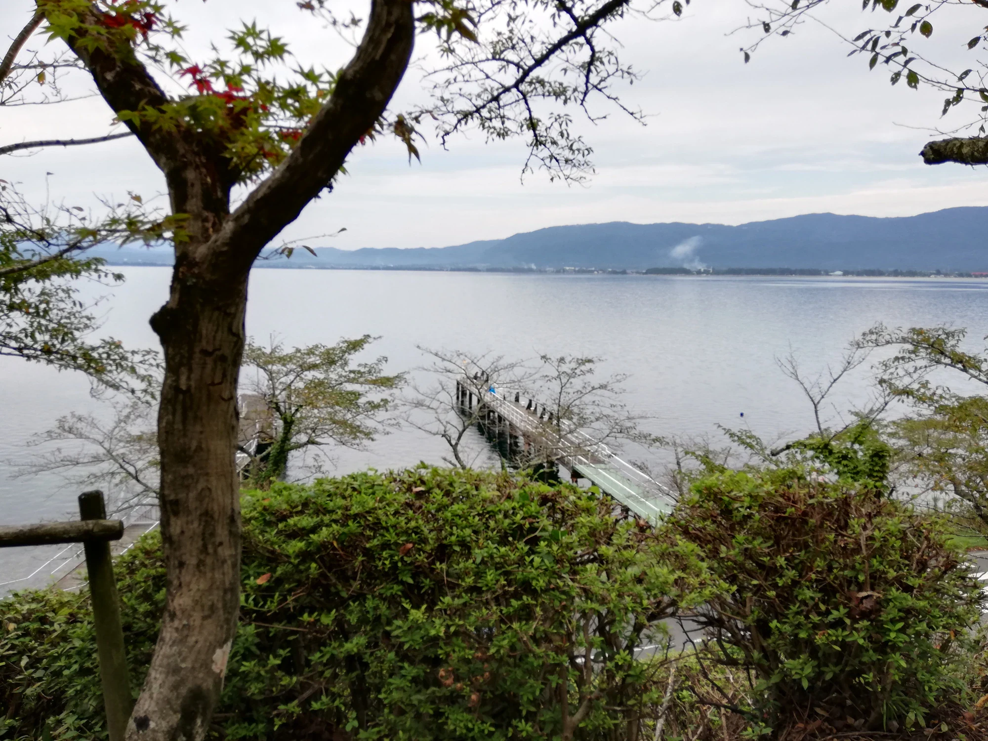
A leafy tree and shoreline shrubs frame Lake Biwa, a narrow pier and hills across the water.

Lake Biwa at Kaizu Osaki, seen from the entrance to Ōsaki-ji in September 2020.

Kaizu Osaki 20200920.jpg — 先従隗始, CC0 1.0 (https://creativecommons.org/publicdomain/zero/1.0/). Source: https://commons.wikimedia.org/wiki/File:Kaizu_Osaki_20200920.jpg. Proportionally resized to a maximum 2000-pixel long edge without upscaling; recompressed as WebP quality 92, method 6. No crop, added text, colour adjustment or retouching. Original retained only as evidence; EXIF omitted from derivative. · Creative Commons

Walks and routes

From Makino Station to the lakeshore park

Follow the official walking approach through Lake Terrace to Ōsaki Namikiguchi, then continue about 400 m to Kaizu Osaki lakeshore park and retrace your steps. The map gives about 2 km from the station to the avenue entrance, making this roughly 4.8 km altogether. Leave time to enjoy the open-water views before returning to Makino.

This combines local approach streets with the headland road; it is not a continuous protected promenade. Keep the group together and shorten the walk if traffic leaves too little comfortable space.


From Makino Station to the lakeshore park

A shorter taste of the headland

Begin at Ōsaki Namikiguchi and turn at the lakeshore park about 400 m farther along. Retracing that section gives an approximately 800 m outing. This distance excludes the approach from your bus stop. Choose it when you want a little blossom or lake scenery without the station walk.

A shorter distance does not remove the shared-road hazard. If you need a protected route, ask locally about a suitable alternative before leaving the station.

A shorter taste of the headland

A relaxed half-day from Makino

Start with the station toilet and a return-travel check. Walk via Lake Terrace, decide at the avenue entrance whether the road feels comfortable, and continue only as far as the lakeshore park if it does. Return to Makino for a meal. Allow 1½–2½ hours for the walk, with extra time for lunch and trains.

Less walking in blossom season

Choose a local bus that suits both your outward and return trip, then use the short headland out-and-back. If the crowds or traffic are too much, turn back rather than pushing farther into the cherry corridor. A separately booked seasonal cruise is another option once its port, access arrangements and operating status are confirmed.

Things to try

Make a three-layer lake photograph

Look for a composition with a nearby tree, the curve of the headland and distant water. Take the picture from an existing safe standing place; do not back into the carriageway or climb down to a pier for a clearer foreground.

Give children a shoreline challenge

At a safe stopping place, ask everyone to find three different textures: ripples on the lake, rough rock and tree bark. A phone close-up or sketch is enough; leave stones, plants and branches where they are.

See the blossom from the water

When the spring programme is running, compare a sightseeing cruise with the road walk. Check the departure port, reservation arrangements, sailing time and whether the trip includes a landing. The 2026 Biwako Kisen programme has ended; wait for the next season’s details before building it into a visit. A cruise is weather-dependent, so it is not a strong-wind fallback.

Make a bad-weather day shorter

Steady rain can make this exposed road-and-shore outing unrewarding, while strong wind is also a reason to rethink a boat trip. Stay around Makino for an indoor meal or move the lakeshore visit to another day. There is no need to turn a scenic stop into a test of endurance.

Wildlife and habitats

The planted Somei-yoshino cherries

In spring, look at how the flowering branches frame strips of water between the trunks. These are planted and maintained trees, with younger replacements among the older specimens. Outside flowering time, enjoy the leafy or bare silhouette without expecting blossom.

A bird of the wider lake: Great Cormorant

Great Cormorants are documented around Lake Biwa, including Chikubushima. They dive for fish. This is useful background to the lake you are looking across, rather than a reason to expect a bird beside this particular path. If birds are present, watch from a safe place on land with binoculars and give them space.

Stories and discoveries

The rocks were famous before your blossom photo

Kaizu Osaki belongs to the Eight Views of Lake Biwa for its rocky shore in dawn mist. That helps explain why the scenery is worth looking at even when the cherry trees are not flowering.

The avenue needs year-round care

The cherry display depends on community work as well as spring weather. The local conservation group organises maintenance, and the city continues to advertise cleanup and weeding sessions along the avenue.

When to visit

Spring: flowers and careful timing

Check the local bloom report before travelling and favour a quieter day if possible. Flowering dates move with the weather, and the road can be busy beyond the formally regulated weekend. Bring hand sanitiser if you expect to use seasonal toilets.

Summer: green shore, bright water

Bring water, a hat and sun protection, and shorten the walk in heat. Keep spontaneous paddling or swimming off the itinerary; use a designated beach during its open season and hours if water play is the aim.

Autumn: come for the landscape

Use a clear day for the headland and distant lake views. Cherry blossom is a spring event, so let the water, trees and changing light be the reason for this visit. Check the wind as well as the chance of rain.

Winter: let conditions decide

Check local road and weather information for snow or ice. Choose a short daylight visit only when conditions suit walking, and keep the return journey simple. Save an exposed lakeshore walk for another day if conditions deteriorate.

Getting there and practical advice

Toilets before the walk

Public toilets are available in front of JR Makino Station. Use them before setting out. The 2026 blossom map showed temporary toilets along the viewing area, with no handwashing facilities, but their installation is seasonal. Ask about current accessible-toilet provision if you need it.

Local advice at Makino Station

Makino Station Tourist Information is the useful contact for the day’s walking approach and blossom arrangements: +81 740-28-1188. Ask about road conditions, return buses and the facilities you need.

Food, water and rubbish

Bring enough drinking water and a snack for your chosen walk. Arrange meals around Makino and carry your rubbish back with you; seasonal food stalls should be treated as a bonus rather than your only plan.

Parking needs an advance plan

The tourism association says there is no dedicated visitor parking at Kaizu Osaki. Use its current access guidance to choose parking before driving out, and confirm availability directly. Do not count on roadside stopping places for parking or passenger pickup.

Arrive at JR Makino Station

JR Makino on the Kosei Line is the local rail gateway. Check the train journey for your date, then either follow the local approach map on foot or connect with a community bus. Plan the trip around this station rather than searching for one entrance to the entire quasi-national park.

Regular buses to the approach

Take the Kunizakai Line to Kaizu 1-ku, about a two-minute walk from the avenue entrance, or the Makino Kōgen Line to Kaizu Ōsakiguchi, allowing roughly 6–10 minutes on foot. The municipal Makino timetable revised on 1 August 2026 lists these regular services. Select the correct direction and day column, check both journeys, and look for separate blossom-season arrangements. The listed single fare is ¥220 for adults and ¥110 for children; recheck before travel.

Driving and cycling near the blossoms

The published spring 2026 plan scheduled eastbound one-way traffic on 4–5 April, 09:30–17:00, on the main Kaizu-to-Nihonmatsu section. Those dates are past and do not establish next spring’s rules. Cyclists were exempt from the one-way restriction and were asked to dismount in crowded Kaizu village. Check the current traffic notice before arrival.

Choosing a manageable stretch

Distance is only part of the decision here: passing traffic and narrow sections may matter more. For a wheelchair, stroller or someone who cannot move aside easily, contact the tourist office first and describe what support you need. Do not assume the whole cherry corridor has a separate pavement.

Check the exact boat

Tell the cruise operator about mobility needs before booking. Its guidance lists boarding steps, a need to stand when boarding some vessels, and different toilet arrangements. Ask specifically about your Kaizu Osaki sailing rather than relying on facilities shown for another boat.

Keep the lake outing safe

Stay on the land route and keep children close at both the roadside and the water’s edge. Wet rocks and working piers are poor places to explore. For canoeing or other small-boat outings, wear a fitted life jacket, follow the operator’s instructions and never set off against a strong-wind warning. Swimming belongs at a designated beach during its operating season and hours.

Sources and useful links

Wildlife you might spot

1

Each card links to a full Explore page with photos, traits, and fun facts.

Snap map for this place

Start with the big picture, then zoom in to explore individual wildlife observations around this place.

Loading map…

Good to know before you go

Check your return bus before setting off. Makino Kōgen is a loop route, so the direction matters.

Use the public toilets in front of JR Makino Station. Blossom-season temporary toilets are not an all-year facility.

Keep children beside you on the narrow road, and stop for photos only where passing traffic has room.

Check the current spring traffic map before driving. There is no dedicated visitor car park at Kaizu Osaki.

Carry water, a snack and a bag for rubbish; plan your main meal around Makino rather than relying on seasonal stalls.

Keep away from wet shoreline rocks and private or working piers. Choose an operating designated beach for swimming.

For canoeing or other small-boat activities, wear a properly fitted life jacket and follow the operator’s weather decision.

Enjoy the trees without pulling branches or stepping into planted areas; local volunteers work to maintain the avenue.

Frequently asked questions

No. The suggested outing stays near Kaizu Osaki on the northwestern shore. The much larger quasi-national park includes other lakeside, mountain and river districts.
No. Turn at the lakeshore park for a shorter outing. Continuing to the Ōsaki-ji area means about 4 km each way from Makino Station, according to the tourism association, so plan a much longer day on the road.
Do not assume so. The published 2026 arrangement used eastbound one-way traffic on the main viewing section. Check the new season’s notice and follow marshals on the day.
The municipal timetable lists regular Kunizakai and Makino Kōgen community buses serving the approach. Check the current day-specific timetable; these are local services with gaps between departures, not an on-demand sightseeing shuttle.
Keep this outing on land. For swimming, use a designated beach during its operating season and supervised hours, and keep children under close adult supervision.
Check before booking. Biwako Kisen’s access guidance says some vessels require passengers to stand during boarding and have internal steps. Ask about the exact boat, departure port, toilet and any landing included in your trip.

Recent snaps at this place

Recent snaps will appear here as new observations are added.

View all ›

Take the discovery with you

Exploring Biwako Quasi-National Park?

Identify the wildlife you spot, learn as you go, and keep a collection of the adventure.

  1. 1Spot it
  2. 2Snap it
  3. 3Keep the discovery




