
Snappit logo
Snappit
Get App
Generic illustration, not a photograph of this venueIllustration
ParkAuvergne-Rhône-Alpes, FR

Chartreuse Regional Nature Park

The Chartreuse stretches across Isère and Savoie, with dark mountain forests below pale limestone cliffs.

About

The Chartreuse stretches across Isère and Savoie, with dark mountain forests below pale limestone cliffs. Grenoble, Chambéry and Voiron are its gateway cities; the park itself is a much larger inhabited landscape of villages, pastures and woods. For a first visit, one carefully chosen corner is more satisfying than a hurried circuit of mountain roads.

The Sentier des Géants at the Col de Porte is a particularly manageable introduction. Its subjects are close at hand: the proportions of a giant tree, the remains of a harvested trunk and the new life growing around old wood. The trail combines interpretation with a modest walk, so children have something to investigate even when the mountains disappear into cloud.

This is also a working forest. Timber production, wildlife habitat and recreation share the same space. Looking at how trees of different sizes fit together gives the outing more depth than simply finding the tallest one. A forestry sign, an old stump or a young tree in a patch of light can be as revealing as a view. Take the ultimate field guide with you: use the Snappit app to identify birds, plants, and animals on your trip.

The regional nature park was created in 1995, but the forest’s human story is much older. The Chartreux established their community in the massif in 1084 and helped shape its woodland economy. Much of the forest became state property in 1792. Today, the Grande Chartreuse national forest is managed for timber, ecological value and visitors, with trees of different ages sharing the same stands.

What to do here

Walk the signed Sentier des Géants from the prairie side of the Col de Porte. Use its interpretation stops to explore the forest’s scale and history, then return for a picnic. Keep the short circuit as your outing; the paths toward La Pinéa and the high summits require a separate plan.

Seasonal info

At roughly 1,300 metres, this woodland is mountain terrain. Check the Col de Porte forecast, road conditions and entrance notices before setting out. Snow, ice, heavy rain or strong wind can make a short outing unsuitable.

Accessibility

“Easy” describes the walk’s general difficulty, not step-free access. The circuit uses woodland paths and includes some ascent. Do not assume it is suitable for wheelchairs or pushchairs; ask the tourist office about current surfaces, slopes and barriers before relying on it.

Don't miss

1

Giant trees and forest interpretation on a compact loop

2

Old wood explained as a home for new life

3

A mountain-forest visit without a summit objective

4

A local snow-research story beside the woodland

Walks and routes

Sentier des Géants: the short forest loop

Start at the Col de Porte car park on the prairie side and find the signed trail and welcome panel. The interpretation sequence includes the Belvédère des Cimes, the sapins présidents and a stop about the Centre d’Étude de la Neige. Follow the short circuit rather than a sign for a distant summit. The panel also identifies a pasture crossing: keep to the route and leave fences as you find them.

Expect a natural-surface woodland walk, with uneven footing and some climbing. Its short length is useful for families, but the ground still deserves attention. Take particular care on wet leaves, roots and stones.
Sentier des Géants: the short forest loop

A comfortable half-day

Arrive with the route already saved and take a few minutes to read the welcome panel. Spend 1½–2 hours on the short circuit, letting the interpretation set the pace. Finish with a picnic near the welcome area, then head back while everyone still has energy. With young children, finishing one satisfying loop is a better plan than promising a summit afterward.

Build the day around your return bus

If arriving on N62, choose the return journey before the outward one. Leave time for reading stops, lunch and walking back to the correct stop. Keep a buffer rather than trying to finish the last activity just as the bus is due. Check which services actually reach La Prairie on your travel date.

Things to try

Follow a tree’s whole life

At one interpretation stop, look for a seedling, a mature trunk and old wood within the same view. Sketch their shapes or photograph the contrast. Ask which parts of the forest would disappear if every old piece of wood were removed. Keep the exercise on the path; lifting bark and moving logs destroys the very habitat you are trying to notice.

Choose the longer map game instead

For children who enjoy finding controls, the separate Col de Porte orienteering leaflet offers twelve stations with questions about trees, forestry and mountain life. It publishes 3.5 km, 80 m of ascent and about 1½ hours; allow longer for puzzles. Download the correct leaflet, supervise the group and stay on paths. Choose it as an alternative outing rather than an automatic add-on for tired walkers.

Change the plan when the woods are unsafe

Heavy rain, strong wind or thunderstorms are reasons to leave the forest walk for another day. For an indoor alternative, consider the Musée Arcabas en Chartreuse at Saint-Hugues, with its richly painted church interior. General admission is free, and the museum offers children’s games and English visit leaflets. Check current opening hours and road access first; guided visits and workshops have separate arrangements.

Wildlife and habitats

Read the needles before the height

The silver fir is one of the defining trees of Chartreuse’s mixed mountain forest. On a branch visible from the path, look for flat needles with two pale bands underneath. Its cones stand upright high in the crown, so a whole cone lying on the ground is not a reliable way to find one. Compare what you see with the interpretation rather than plucking a twig.

The broadleaf partner

Beech shares these woods with conifers. Its relatively smooth, pale-grey bark gives you a useful starting clue, especially when the leaves are gone. Look up from the trunk to the branching crown, then compare its outline with a neighbouring fir. Learning that contrast is often more rewarding than trying to name every tree in one visit.

A forest inhabitant you may hear first

The park records black woodpeckers in its mountain forests. Their calls can carry through the trees, and their large nesting cavities may later shelter other animals. A distant sound or a hole is not enough for a confident identification, so enjoy the forest without turning the walk into a search for a nest. Watch from the path and never use playback to draw birds closer.

Stories and discoveries

A stump can be the beginning

The trail introduces the local forestry word tapon for a large basal section of harvested wood left behind. What first looks like waste can hold moisture, decay into the forest floor and support new growth. The interpretation makes a good question for children: is an old tree really finished being useful?

Snow has a long record here

The Col de Porte is a major Météo-France snow-study site, with systematic measurements dating from winter 1960–1961. Its long record shows how mountain winters have changed, while individual years remain very different. Read the trail’s snow-research stop from the public route; scientific equipment and enclosures are not visitor play areas.

The white walls have a much older story

The limestone scenery belongs to a landscape formed through sedimentation, uplift, folding and erosion over immense spans of time. From a clear viewpoint, compare the wooded slopes with the harder pale rock above. You do not need to reach a cliff edge or enter a cave to appreciate that contrast.

When to visit

Late spring and summer

Wait until the trail is genuinely snow-free. In warm weather, start with enough time to enjoy the shaded forest and stop before any forecast thunderstorm arrives. Carry water even when the woods feel cool, and respect livestock whenever the pasture is occupied.

Autumn

The contrast between broadleaved trees and conifers becomes especially easy to notice. Shorter days, wet leaves and early frost make an unhurried but early start sensible. Consult the ONF hunting-calendar link and local notices, and respect any temporary restrictions.

Winter

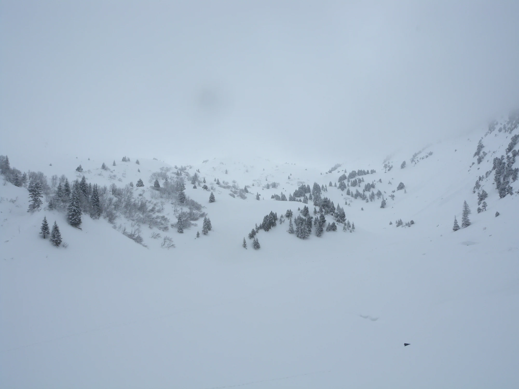
Treat winter as a different trip with its own marked activities, conditions and equipment. The summer trail’s small distance is no guide to snow-covered terrain. The historical photograph below is a reminder of how completely snow and fog can transform the same massif.

Snow covers a mountain hollow dotted with dark conifers and bare shrubs, while the upper slopes disappear into thick fog.

Snow and fog in the Chartreuse massif, photographed in March 2009. The exact slope is unidentified; this historical view is separate from the Sentier des Géants and does not show current conditions.

“in the fog” — Jerome Bon, CC BY 2.0. Source: https://www.flickr.com/photos/girolame/3356936685/. License: https://creativecommons.org/licenses/by/2.0/. Original unchanged. · Creative Commons

Getting there and practical advice

A useful starting area

The ONF describes a sheltered welcome area and picnic facilities at the prairie of the Col de Porte. The local operator lists free parking on the prairie side. Bring your own water and food, and check toilet provision and restaurant opening times beforehand if these are important to your group.

By public transport from Grenoble

N62 links Grenoble Notre-Dame–Musée with the Col de Porte on selected services. Use the current M réso timetable: school-term weekdays, holidays and weekends differ, and seats are limited. Reservation is strongly recommended where offered, including for the return. The 2026–2027 timetable suspends La Prairie service from 28 November 2026 to 29 March 2027; that does not make the summer forest circuit a winter walking route.

An autumn 2026 bus change

From 12 October to 6 November 2026, Le Gorget is not served on weekdays between 07:30 and 16:30 because of roadworks. M réso directs passengers to Saint-Germain or Monument. Recheck the notice before travel, particularly if your accommodation is near the affected stop.

By road

Use the Col de Porte prairie-side parking rather than treating the upper Charmant Som road as part of the short visit. Check Itinisère and Sarcenas notices for roadworks, winter restrictions and events. The mountain road and the footpath can have different restrictions; an open car park is not proof that the trail is suitable.

Ask about the whole journey

For a wheelchair user or anyone who needs predictable footing, request details of slopes, surface, gates and the connection from parking or the bus stop. The official walk’s “easy” rating supplies none of those measurements. An accessible parking space or shelter would not, by itself, establish access around the loop.

For younger children

A child who is happy with a short uneven walk may enjoy the tree stations more than a long landscape hike. Keep the group together at junctions and pasture crossings. If using a carrier, allow for the adult’s balance and the child becoming cold while sitting still; shorten the outing when conditions deteriorate.

Sources and useful links

Wildlife you might spot

3

Each card links to a full Explore page with photos, traits, and fun facts.

Snap map for this place

Start with the big picture, then zoom in to explore individual wildlife observations around this place.

Loading map…

Good to know before you go

Save the official route description and panel before leaving.

Wear shoes with grip and bring a warm layer, water and a snack.

Keep dogs on a lead and give grazing animals plenty of room.

Respect fences, forestry closures and any hunting signs; never step around a barrier.

Leave fallen wood, fungi and plants in place, and take all litter home.

Do not light a fire or barbecue on the trail.

Frequently asked questions

Use the 1.7 km Sentier des Géants listing and its linked panel, which gives a slightly different distance of 1.6 km. The 3.5 km children’s orienteering course is a separate activity; its distance and ascent should not be added to, or substituted for, the short trail.
Yes, on a lead on the Sentier des Géants. Stay well clear of livestock. Do not assume this permission extends to every protected area or mountain pasture elsewhere in the Chartreuse.
No. The park includes public and private land. Follow current official routes and respect access restrictions. A route on an old map, or a path visible on the ground, is not permission to cross a closure or private-property sign.
No. It is a historical view somewhere in the Chartreuse massif, taken in March 2009. Its exact slope is unidentified. It illustrates winter atmosphere and says nothing about present snow, avalanche conditions or the Sentier des Géants.
The trail is presented as an independent walking itinerary. You can use its interpretation without arranging a guide. Book separately if you choose an organised activity, and check the bus reservation arrangements if travelling without a car.

Recent snaps at this place

Recent snaps will appear here as new observations are added.

View all ›

Take the discovery with you

Exploring Chartreuse Regional Nature Park?

Identify the wildlife you spot, learn as you go, and keep a collection of the adventure.

  1. 1Spot it
  2. 2Snap it
  3. 3Keep the discovery





