Snappit logo
Snappit
Get App
Generic illustration, not a photograph of this venueIllustration
ParkIT

Madonie Regional Nature Park

Choose one side of the mountains before choosing your walk.

About

Choose one side of the mountains before choosing your walk. Castelbuono is the natural starting point for the Piano Sempria approach to Piano Pomo; Polizzi Generosa suits the celebrated fir trail; Petralia Sottana and Isnello give you other ways into the uplands. Trying to combine all of them in one day leaves too much time on winding roads.

The pleasure here is in the change of scale. A village street can introduce fossils in building stone; higher up, broad limestone landscapes and woodland tell a much older story. The park was established in 1989 and covers roughly 40,000 hectares. Its towns, working pastures and woodland belong to the same landscape, so leave time for a meal and a wander as well as the headline walk. Explore the grounds like a pro—download the Snappit app to instantly identify animals and plants.

The protected park was created by the regional decree of 9 November 1989. Its character reaches further back: former seabeds became mountains, while generations of grazing, farming and woodland use shaped the inhabited landscape. The Madonie also belong to a UNESCO Global Geopark. That broader geological designation is useful context, but it should not be treated as the same administrative boundary as the regional nature park.

What to do here

For a first visit, pair one confirmed-open trail with its nearest town. Choose the shorter Piano Sempria–Piano Pomo approach for a woodland outing, or the Abies nebrodensis trail for a more substantial walk with a strong conservation story. For a gentler day, follow Petralia Sottana’s urban geological route. Piano Battaglia offers a different, open upland setting, but reaching the area by road does not make every walk from it easy.

Seasonal info

Summer heat and fire restrictions can change a plan quickly. In winter, snow, ice and poor visibility can make upland paths and roads unsuitable for an ordinary sightseeing day. A village plan is worth having ready in every season.

Accessibility

A shorter walk is not automatically step-free. The woodland routes have natural surfaces, and old town streets can be steep or uneven. Assisted Joëlette outings have been advertised, but these require advance arrangements and accompanying staff.

Don't miss

1

Piano Pomo’s remarkable holly woodland, viewed from permitted paths

2

The conservation story of the endemic Sicilian fir

3

Karst scenery around Piano Battaglia

4

Fossils, stonework and lived-in mountain towns

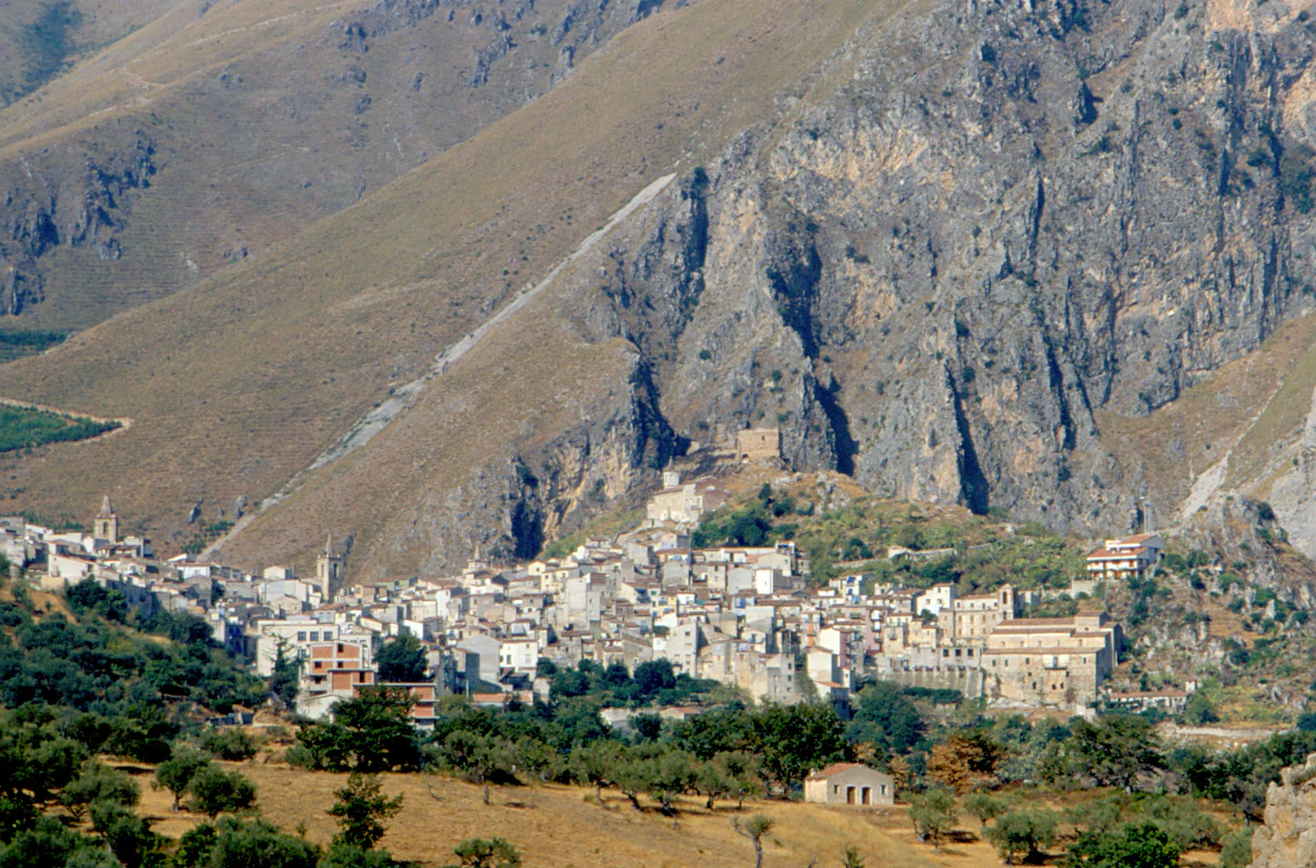
A compact town with church towers beneath a tall pale rock face, with scattered trees and fields in the foreground.

Isnello sits beneath the rocky slopes of the Madonie in this historical view. The source dates the file to 2007; the original slide’s capture date is unconfirmed.

“Il paese ai piedi della montagna” / Madonie 5 0048.jpg — Carlo Columba. Copyright Carlo Columba. Source: Wikimedia Commons; CC BY-SA 2.5 Italy. Unchanged source-original file. · Creative Commons 1 · Creative Commons 2

Walks and routes

Piano Sempria to Piano Pomo

The shorter approach to Piano Pomo starts by Rifugio Crispi at Piano Sempria, reached from Castelbuono via the San Guglielmo approach. The park’s tree booklet places the holly woodland about 1.3 km along the nature path from Piano Sempria. That is an outward distance. Return by the same permitted route unless you have arranged another itinerary; the longer Case La Pazza crossing is a separate undertaking.

Natural woodland trail; no verified step-free specification. Allow extra time for your own pace and the return, and confirm the condition of the approach road and permitted parking.


Piano Sempria to Piano Pomo

Sentiero degli Abies nebrodensis

The park leaflet gives 8.3 km out and back, about 3 hours of walking and medium difficulty. It starts at the forest gate in the Quacella area, around kilometre 8 of the SP119 from Polizzi Generosa. Expect changing vegetation, views of the Quacella rock formations and a substantial climb. Leave enough daylight for the return.

Uneven ground, climbing and a railed section require care. The leaflet quotes 400 m of uphill elevation change, but does not explicitly define a cumulative-ascent total. Ask for tailored accessibility advice if needed.

Sentiero degli Abies nebrodensis

Case La Pazza–Piano Pomo

Choose this longer pastoral crossing only after discussing the current itinerary with the park or a local guide. The official sheet starts near the Hotel Pomieri access on the SP54 and continues through the Case La Pazza area towards Piano Pomo, Piano Sempria and a finish at Milocca. It describes stream crossing and steep, stony terrain and grades the outing EE, for experienced hikers. The old sheet’s figures and route description do not provide one clear, consistent distance and return arrangement; do not set out expecting a simple three-hour loop.

Demanding natural terrain. Arrange the exact permitted variant, walking time and collection point before starting.

Case La Pazza–Piano Pomo

Petralia Sottana urban geology walk

For a lower-effort introduction, follow the town’s geological itinerary, marked with brass studs. The park describes Miocene fossils underfoot, corals in stone doorways, and fountains and springs along the route. Allow an unhurried hour or two for looking around, with a café or museum stop if open. That is a suggested visit allowance rather than an official trail time.

Town-based does not mean level or step-free. Check individual streets, slopes, steps and the entrance to any indoor stop if these matter to you.

Petralia Sottana urban geology walk

A first woodland day

Base the day around Castelbuono. After checking access, drive to the Piano Sempria starting area, take the permitted outward-and-return walk towards Piano Pomo, then return to town for the rest of the afternoon. Keep the day flexible rather than adding the Case La Pazza crossing or a summit.

Two different mountain days

Give the fir walk from the Polizzi Generosa side its own day. On another, choose Petralia Sottana’s urban geology and a confirmed-open museum, or arrange a geological walk near Piano Battaglia if conditions suit. A third day leaves room for another valley or a more ambitious guided hike.

Things to try

Piano Battaglia: geology before summit ambition

Around Piano Battaglia, the official Inghiottitoio della Battaglietta–Portella Colla geological route interprets carbonate rock and karst landforms. It is a useful theme for a guided outing, with cavities observed from the authorised surface route. Pizzo Carbonara is a separate, more demanding goal: the park’s summit itinerary is graded EE and calls for excellent visibility because the path is not always clear. Do not turn a casual plateau visit into an improvised summit attempt.

Make room for a village

Isnello has its own official urban geological itinerary, while Castelbuono and Polizzi Generosa make useful town stops beside their respective walking areas. Pick one place to explore slowly. Streets, churches and everyday food stops give the mountains a human context, and staying nearby makes an early start easier than repeatedly returning to the coast.

An indoor alternative

The park lists Museo Civico “Antonio Collisani” in Petralia Sottana and Museo Naturalistico “F. Minà Palumbo” in Castelbuono. Confirm hours, tickets and step-free access before setting out. In a severe-weather alert, use a safely reachable, confirmed-open venue rather than travelling across the mountains simply to salvage a planned walk.

Wildlife and habitats

Holly

Piano Pomo’s holly population is identified by the park as Ilex aquifolium. Here it forms trees rather than the small shrubs many visitors expect. Appreciate the woodland from the permitted path; do not step into the stand or pause beneath a large specimen.

Fir

The local conservation story concerns the Sicilian fir, Abies nebrodensis. CNR’s LIFE4FIR work combines protection in the wild with propagation and long-term seed and tissue conservation. Its rarity makes the fences and path rules part of the experience. Other conifers also grow beside the trail.

European Beech

The park records Fagus sylvatica at Piano Pomo, and beech woodland is part of the higher Madonie landscape. Its seasonal changes help explain the mountains’ contrast with the coast.

Holm oak

Quercus ilex is documented in the woodland at Piano Zucchi. These evergreen oaks add another layer to the park’s varied tree cover.

Red Fox

The park lists the red fox among its fauna. A sighting is a bonus, not an itinerary stop. Keep your distance and your food packed away; neither feeding nor following an animal is part of a responsible visit.

Stories and discoveries

Mountains with a marine past

Limestone here carries evidence of former seas. The park’s geology routes connect that deep history to things you can recognise, from dissolved-rock landforms in the uplands to fossils incorporated into town buildings. You do not need to collect anything to take the story home.

Conservation beyond the fence

Saving a very small tree population involves more than protecting its trunks. LIFE4FIR addresses genetic diversity, young plants, grazing pressure and stored reproductive material. The landscape walk is only the visible part of that longer scientific effort.

When to visit

Heat and fire season

Start from the current fire and heat bulletin, not the assumption that elevation solves the heat. Carry enough water for the whole outing and avoid a long exposed route in unsuitable conditions. Regional Civil Protection publishes daily fire-risk notices; the park’s own restrictions and local instructions govern where you may go.

Winter and low cloud

When snow, ice, wind or cloud affects the uplands, switch to a town plan and confirm that the road to it is usable. A bright coast is no guarantee of mountain conditions. Keep ambitious summit walking for appropriate experience, equipment and visibility.

Getting there and practical advice

Information, water and stops

The Qui Parco points in the towns provide route and local-interest information. For current advice, contact the park office in Petralia Sottana on +39 0921 684011 or use its official contact page. Stock up in town: the park’s visitor rules warn that water, toilets, food outlets and medical facilities are not generally available in the interior, apart from tourist areas along main roads and in municipalities. Confirm any refuge opening you intend to rely on.

Getting there and getting back

The A19 and A20 provide the broad road approaches; the best exit depends on which gateway you choose. Cefalù is a useful rail arrival point, but a coastal train does not take you to the mountain trailheads. The park points visitors towards bus operators and car hire for onward travel. Check a journey-date timetable and the final return, especially on weekends and holidays. A prearranged transfer or a car is often the simpler option for a specific trailhead. Do not navigate only to “Madonie Park”: use the verified starting point for your chosen outing.

Arrange the help that fits your visit

The park’s Break the Limit page describes Joëlette excursions with Madonie a passo lento and Madonie Outdoor. Its listing dates from 2019, so ask the park to confirm the current provider and what can actually be arranged. Discuss transfer into the chair, accompanying staff, journey length and accessible toilets. For a town-based day, ask about slopes, steps and the museum entrance too.

Sources and useful links

Wildlife you might spot

5

Each card links to a full Explore page with photos, traits, and fun facts.

Snap map for this place

Start with the big picture, then zoom in to explore individual wildlife observations around this place.

Loading map…

Good to know before you go

Check the park’s latest notices before leaving your accommodation, including temporary wildlife-control exclusion zones.

Carry your own drinking water and food for a mountain walk; a fountain or refuge marked in an old leaflet is not a guaranteed service.

Bring hiking footwear, layers and an offline copy of the official route information.

Stay on permitted paths and outside fences. Give veteran trees plenty of space, including in calm weather.

Arrange your return transport first. A route ending at another road is not necessarily a loop.

Frequently asked questions

Yes, as a focused day trip rather than a circuit of the whole park. Pick a town and one nearby activity, and leave room for mountain-road travel. Without a car, confirm both your onward connection and your return before committing to a trail.
Plan around the individual activity. The park’s visitor portal covers a dispersed territory rather than a single timed-entry attraction. Confirm charges and booking directly for a guided walk, museum, accommodation or organised accessibility service; do not assume one ticket covers them all.
Match the route to their experience and the conditions. A short woodland outing or town-based geology is a better starting choice than a demanding crossing. Keep children clear of old trees, fences and rock edges, and turn back while they still have energy for the return.
The park’s published June 2026 visitor restrictions prohibit camping, bivouacking and lighting fires. Arrange lawful accommodation and do not interpret a picnic area as permission to camp or cook over a flame.
The fir route is an official interpretive walk, but access restrictions and conservation needs come first. Animals are wild and sightings are uncertain. Enjoy what is visible from the authorised route; never enter a protected enclosure or approach an animal to get a photograph.

Recent snaps at this place

Recent snaps will appear here as new observations are added.

View all ›

Take the discovery with you

Exploring Madonie Regional Nature Park?

Identify the wildlife you spot, learn as you go, and keep a collection of the adventure.

  1. 1Spot it
  2. 2Snap it
  3. 3Keep the discovery