
Snappit logo
Snappit
Get App
Generic illustration, not a photograph of this venueIllustration
ParkKR

Seoraksan National Park

For a first visit, use the Seorakdong gateway on the Sokcho side and follow the valley through Sinheungsa toward Biseondae.

About

For a first visit, use the Seorakdong gateway on the Sokcho side and follow the valley through Sinheungsa toward Biseondae. You can turn back early and still enjoy the changing relationship between forest, streambed and cliffs. Ulsanbawi’s stair climb, the high summit of Daecheongbong and the reservation-controlled Heullimgol route deserve separate plans. Pick one main objective rather than treating the park’s famous names as stops on a single easy circuit. Unlock an interactive field guide for this spot: get the Snappit app to identify nature on the go.

Seoraksan became South Korea’s fifth national park in 1970, following natural-monument protection in 1965. Mount Sorak joined UNESCO’s biosphere-reserve network in 1982. These overlapping designations explain the emphasis on habitat protection alongside public access; the biosphere reserve and the national park are not interchangeable boundary descriptions.

What to do here

Walk the lower Biseondae approach, spend unhurried time around Sinheungsa, or choose one harder hike if conditions and fitness allow. Photography works well from established paths: frame pale rock against dark pines, or give the valley itself space in the picture. Keep bridges and narrow decks clear while stopping.

Seasonal info

The valley and the high ridges can feel like different seasons. Spring thaw, summer downpours, autumn fire-prevention restrictions and winter snow or ice can change the usable route. Recheck the exact trail, rather than relying on a general “normal” park status.

Accessibility

The lower approaches offer the most flexible options. KNPS describes wheelchair access on the initial part of the Biseondae nature trail and the first approximately 1.2 km of the Biryong route. Neither statement makes the complete waterfall or cliff route step-free. Confirm current surfaces, gradients and usable turnaround points with the park before travelling.

Don't miss

1

A valley walk through Sinheungsa toward Biseondae

2

Ulsanbawi’s rock skyline and demanding final staircase

3

Different mountain landscapes from the eastern, western and southern gateways

4

A protected home for Korean gorals, dwarf stone pines and wild otters

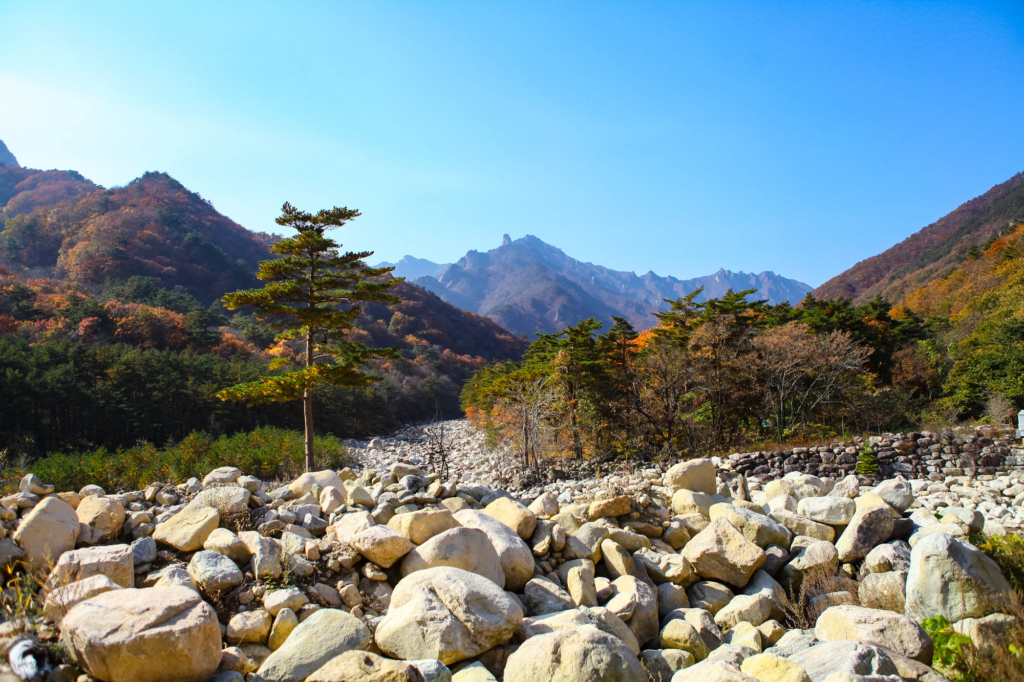
A boulder-filled valley framed by green pines and autumn-coloured slopes, with jagged mountain ridges under a clear blue sky.

Pale boulders, pines and autumn woodland below Seoraksan’s ridges, photographed on 5 November 2021. The exact valley is unverified; this historical landscape is not a report of today’s trail or water conditions.

Photo: [“Seoraksan National Park”](https://www.flickr.com/photos/192730404@N08/51715912102/) by [A Fun Couple (fritz.guillaume)](https://www.afuncouple.com), Flickr. [CC BY 2.0](https://creativecommons.org/licenses/by/2.0/deed.en). Original file unchanged. · Creative Commons 1 · Creative Commons 2

Walks and routes

First choice: Seorakdong to Biseondae

Start at Sogongwon, the entrance area, and follow the signed route by Sinheungsa and Waseondae toward Biseondae. KNPS lists 3.0 km and about 1 hour 20 minutes one way to Biseondae; return by the same route, roughly 6.0 km in total. The early valley section leaves room for a shorter outing, while the later rocky paths and steps bring the cliffs closer. Stop at Biseondae rather than automatically continuing into Cheonbuldong Valley. See the official course description.

Expect an initially gentle approach followed by uneven stone, steps and decks. Wheelchair suitability applies only to the lower nature-trail section, not the entire walk.


First choice: Seorakdong to Biseondae

Separate harder choice: Ulsanbawi

The route climbs via Heundeulbawi and Gyejoam to Ulsanbawi. KNPS publishes 3.8 km and about 2 hours one way, or 7.6 km and about 4 hours walking for the return. The final 1.0 km takes roughly an hour of that outward estimate because the stairs are steep. Allow additional time for rests and congestion, and decide at Heundeulbawi whether the final climb suits everyone. Open the Ulsanbawi course.

A sustained stair climb with steep rocky terrain is unsuitable as a step-free alternative. Consider knee comfort on the descent as well as uphill stamina.

Separate harder choice: Ulsanbawi

Waterfall alternative: Biryong and the Towangseong viewpoint

Choose this branch instead of trying to add every valley to one day. KNPS lists Sogongwon–Biryong Falls at 2.4 km and about 1 hour one way. The Towangseong Falls viewpoint adds 0.4 km and about 30 minutes of steep steps, making 2.8 km and 1½ hours outward. You view Towangseong from a designated viewpoint; the route is not a walk to the foot of that waterfall. Open the waterfall course.

The first approximately 1.2 km is described by KNPS as usable by wheelchairs and strollers. The full waterfall route includes decks and stairs, and the final viewpoint climb is particularly steep.

Waterfall alternative: Biryong and the Towangseong viewpoint

Plan ahead: Heullimgol in South Seorak

Heullimgol is a separate southern mountain route with controlled one-way travel. The June 2026 KNPS amendment defines the managed section as Heullimgol Visitor Support Centre to Yongso Junction, 3.1 km. That is not the complete door-to-door trip: establish the permitted onward exit and return transport before starting. Read the 2026 notice and check Heullimgol reservations.

Treat this as a mountain hike, not an accessible lower-valley substitute. Confirm the route and fitness requirements with KNPS before booking.

Plan ahead: Heullimgol in South Seorak

Experienced hikers: Daecheongbong from Osaek

The short route on a map is still a serious ascent. KNPS gives the Osaek route from Namseorak Visitor Support Centre to Daecheongbong as 5.0 km and about 4 hours one way, or 10 km and about 8 hours return. The steep stone-and-step climb requires a full mountain-day plan, suitable equipment and enough margin to descend safely. Daecheongbong reaches 1,708 m above sea level. Open the Osaek summit course.

Continuous steep climbing makes this a poor default for beginners or visitors seeking a gentle day. A summit elevation is not the route’s total ascent.

Experienced hikers: Daecheongbong from Osaek

An easy-paced first visit

Arrive at Seorakdong in the morning, check the notices, and set a turnaround time. Spend time by Sinheungsa, then continue along the Biseondae approach only as far as the group comfortably wants. Return before fatigue turns the stone steps into a chore. If transport is slow or the weather closes in, shorten the valley walk instead of removing your return margin.

A focused hiking day

Choose Ulsanbawi as the day’s main effort. Build in breaks, assess everyone again at Heundeulbawi, and descend without adding a second major climb. Reserve any remaining energy for an unhurried exit and the journey back to Sokcho. Save Osaek, Heullimgol or Baekdam for a separately planned visit.

Things to try

Give Sinheungsa some time

The temple provides a cultural pause near the start of the main valley visit. Sokcho’s heritage guide traces its earlier foundation to Hyangseongsa and describes its present-site rebuilding in 1644. Look for the relationship between temple roofs, wooded slopes and mountain backdrop. Keep voices low around worshippers, follow photography signs and avoid treating occupied halls as scenery to walk through.

Consider Gwongeumseong by cable car

This is a weather-dependent alternative for mountain views. Tickets are sold on the day only, and operating hours change with conditions. At the October 2026 check, standard return fares were KRW 16,000 for middle-school age and above, KRW 12,000 for ages 37 months through elementary school, and free below 37 months. Confirm the operator’s current timetable and fares before joining a queue.

Explore a different side at Baekdam

Baekdamsa and its valley offer an Inner Seorak visit from Yongdae in Inje. The approach road is narrow, general private cars are not permitted, and the KNPS guide describes a shuttle option. Check the current shuttle schedule and last return with Yongdae Hyangto Enterprise, 033-462-3009. Do not assume walking beside the shuttle road is a segregated pedestrian trail. Treat this as another day’s gateway rather than an extension of the Biseondae walk.

When the mountain plan falls through

In light rain, a shorter temple-area visit is an option only if that approach is open and safe. In heavy rain or high wind, leave the mountain outing for another day. The cable car is also weather-dependent, so it is not a guaranteed rainy-day fallback.

Wildlife and habitats

Eurasian Otter

A February 2026 KNPS release reported a wild otter family captured by camera traps in Seoraksan. Otters are usually active at night, so enjoy the stream habitat without expecting an encounter. Stay on the path, keep food and rubbish contained, and leave bank-side hiding places alone.

Pines

Pines belong to the genus Pinus. Seoraksan surveys record red pine, Korean pine and dwarf stone pine, illustrating how different members of the same genus occupy this mountain landscape. You do not need to reach an alpine site to appreciate the contrast between evergreen needles and broadleaved forest. Do not collect cones or assume every visible evergreen is a pine.

Stories and discoveries

Rock is part of the park’s identity

Much of Seoraksan’s striking terrain is granite, but the mountain is not one uniform block: KNPS describes older granitic gneiss near Daecheongbong and sedimentary rocks south of Baekdamsa. The contrast between exposed rock, deep valleys and forest is worth noticing even on a lower walk.

The high mountain protects a different plant world

The dwarf stone pine, Pinus pumila, is a Seoraksan flagship plant associated with the Daecheongbong–Socheongbong area. Its low, spreading growth is part of the alpine landscape, and its habitat has special protection. The other flagship is the Korean goral, Naemorhedus caudatus, adapted to steep rocky slopes. Neither is a promised sight on the Biseondae walk; never leave a trail to search for them.

When to visit

Spring: stay flexible during thaw

Choose lower routes after checking fire-prevention and thaw-related restrictions. A warm day in Sokcho is not proof that high paths are ice-free. The park’s spring notices distinguish different closure periods for ordinary high trails, Gombaegol and Heullimgol.

Summer: keep an eye on the catchment

Heavy rain upstream can make a valley outing unsafe even when your immediate patch of sky looks better. Abandon gorge or waterfall plans when warnings or ranger instructions require it; do not seek a closer view of swollen water.

Autumn: choose time over extra stops

Leave room for slower travel and crowded stairs during foliage season. Finish the chosen walk while there is generous daylight rather than chasing another viewpoint. Check autumn fire restrictions and Heullimgol booking rules independently.

Winter: reassess the whole plan

Snow, ice and wind can turn a familiar-looking path into a different undertaking. A short valley visit may be the right choice, or no mountain visit at all. Do not use a summer walking-time estimate as a winter safety margin.

Getting there and practical advice

Costs, toilets and a useful phone number

Sokcho’s official visitor guide lists park admission as free. Parking, cable-car tickets and transport are separate expenses; confirm the actual charges before committing. Use toilets near Sogongwon before a longer outing and carry your own essentials. For route-specific access or assistance questions, contact Seoraksan National Park at 033-801-0900.

Reach the right gateway

For this first-visit plan, travel to Seorakdong/Sogongwon on the Sokcho side. The cable-car operator lists Sokcho city buses 7 and 7-1 to the Seoraksan parking-area terminus. Confirm the current stop, departures and final return locally; this guide does not assume a fixed timetable. If driving, verify which Seorakdong parking area your navigation selects and allow for a queue or a longer walk.

Match the outing to the access you need

Ask KNPS about the exact lower trail you intend to use, including temporary surfaces and the nearest suitable toilet. For the cable car, the operator confirms wheelchair boarding and an elevator to the lower boarding floor; strollers cannot be taken aboard. This does not establish a step-free route across the rocky terrain beyond the upper station. Confirm your mobility device and desired viewing area directly with the operator.

Sources and useful links

Wildlife you might spot

2

Each card links to a full Explore page with photos, traits, and fun facts.

Snap map for this place

Start with the big picture, then zoom in to explore individual wildlife observations around this place.

Loading map…

Good to know before you go

Check both the [Seoraksan trail-control notice](https://www.knps.or.kr/front/portal/safe/acsCtrDtl.do?menuNo=8000340&rstId=0008) and the [entry-cutoff table](https://www.knps.or.kr/portal/main/contents.do?menuNo=8000198) before departure and again at the trailhead.

Wear grippy footwear and carry water, food, a warm layer and rain protection. For a longer hike, add a headlamp and a route plan that does not depend on phone signal.

Turn back with enough time and energy for the descent. A short final section can contain the steepest stairs.

Keep to open marked paths. Do not step into the streambed or behind barriers for a photograph, and leave plants and animals undisturbed.

Frequently asked questions

No. The Seorakdong–Sinheungsa–Biseondae approach gives you a satisfying valley visit. Choose a shorter return walk if stairs, time or weather make the full route unsuitable.
The Biseondae walk is distinct from the controlled reservation routes. Check your chosen course rather than assuming every entrance uses the same system. Heullimgol has a seasonal reservation requirement, and an overnight shelter stay needs separate planning through KNPS.
The operating Seorak Cablecar goes to Gwongeumseong. Plan it as a separate outing. Its operator says there is no walking descent from the cable-car destination, so return by cable car and keep track of the last service.
Take a break and consider returning at an easy pace. Geumganggul’s short-looking extension involves steep stairs; the current KNPS control notice gives a 14:00 cutoff for that visit. Continuing toward Yangpok and the high mountains is a much larger commitment.

Recent snaps at this place

Recent snaps will appear here as new observations are added.

View all ›

Take the discovery with you

Exploring Seoraksan National Park?

Identify the wildlife you spot, learn as you go, and keep a collection of the adventure.

  1. 1Spot it
  2. 2Snap it
  3. 3Keep the discovery








