
Snappit logo
Snappit
Get App
Generic illustration, not a photograph of this venueIllustration
ParkTohoku, Japan

Shimokita Hanto Quasi-National Park

At Osorezan, the quiet surface of a lake sits beside a landscape of bare volcanic ground and places of remembrance.

About

At Osorezan, the quiet surface of a lake sits beside a landscape of bare volcanic ground and places of remembrance. On the opposite coast, Hotokegaura’s huge pale rocks rise straight from the shore. Elsewhere, Yagen offers river sounds and forest shade, Oma opens onto the Tsugaru Strait, and Shiriyazaki brings a lighthouse and grazing horses into a broad coastal view. This is one designated park with widely separated sectors, rather than a single entrance and a circular sightseeing road. Start with the place you most want to experience. Two or three days allow a much kinder pace than trying to collect every headline sight in one day. [Official park overview](https://www.pref.aomori.lg.jp/soshiki/kankyo/shizen/kouen_shimokita.html). Explore the grounds like a pro—download the Snappit app to instantly identify animals and plants.

What to do here

Choose a quiet Osorezan visit, a weather-dependent Hotokegaura boat trip, a short Yagen forest walk, or a cape outing. Stronger mountain walks around Nunodoishiyama and the inland peaks need their own current route information and equipment; they are not extensions of the short walks below.

Seasonal info

Checked 19 October 2026: Osorezan closes at 17:00, and its announced final bus toward Shimokita Station leaves at 15:55. Oku-Yagen Bridge has works scheduled through 30 November. Shiriyazaki lighthouse visits pause 09:00–10:00 on 20 and 27 October. Check the linked notices again before travelling.

Accessibility

The easiest-looking option can still have a difficult last stage. Hotokegaura boats avoid the steep land approach, but the operator cannot board someone seated in a wheelchair. Forest paths, rocky shore and temple routes need individual assessment; no complete step-free park itinerary has been verified.

Don't miss

1

Osorezan’s volcanic landscape and lakeside place of remembrance

2

Hotokegaura’s wave-shaped tuff formations

3

Yagen’s riverside forest and logging history

4

Oma’s northern horizon and Shiriyazaki’s lighthouse

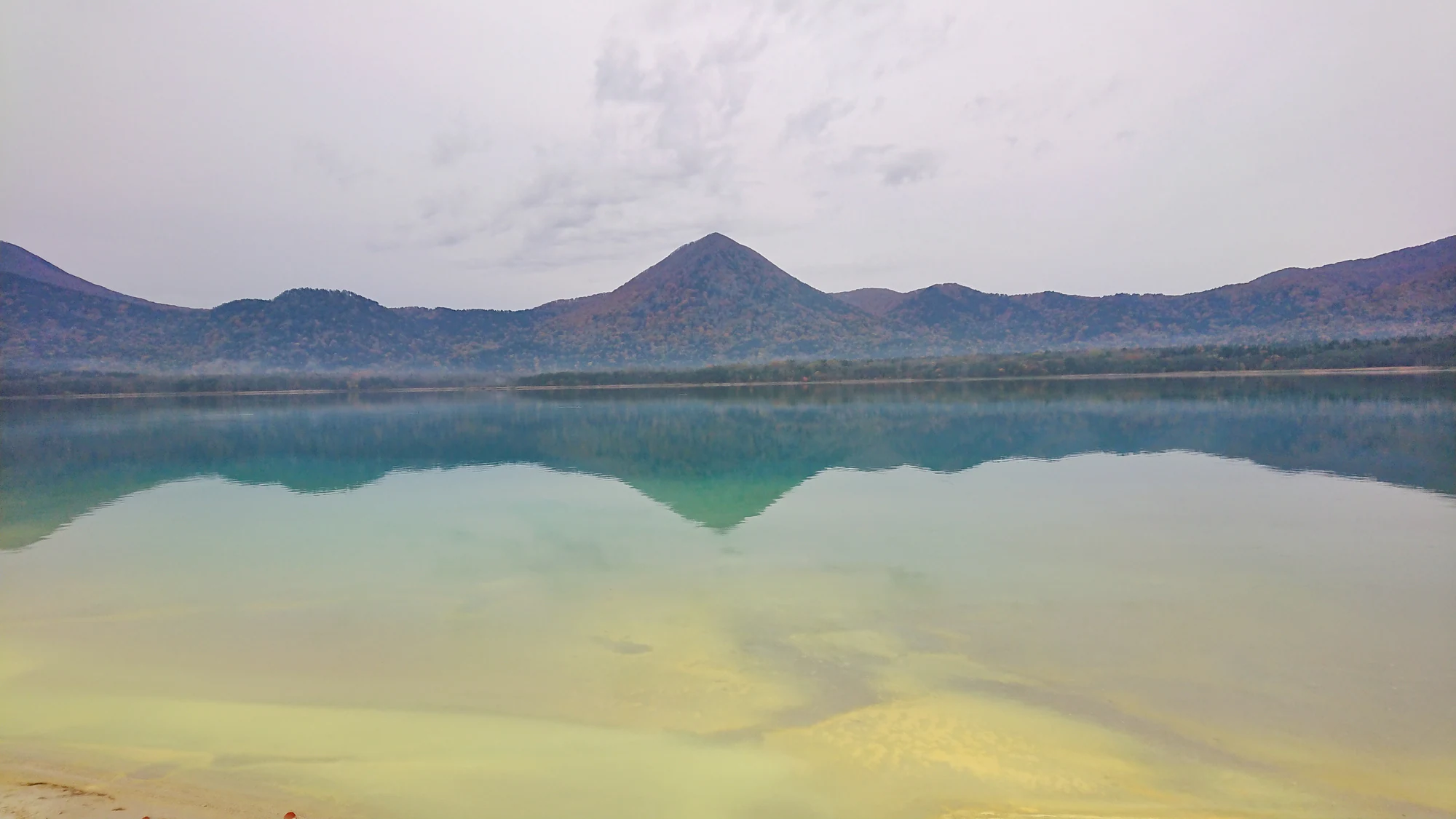
Still green-blue lake water reflects a wooded mountain ridge beneath a pale cloudy sky, with shallow water visible in the foreground.

A lake and wooded mountain rim at Osorezan, in a photograph published by the Japan Meteorological Agency. The capture date is unknown; the image does not show current weather or access conditions.

Source: Japan Meteorological Agency, Osorezan photograph 03, https://www.data.jma.go.jp/vois/data/filing/kazanbosai/volpictures.html#201. PDL1.0: https://www.digital.go.jp/resources/open_data/public_data_license_v1.0. No changes. · Creative Commons 1 · www.digital.go.jp 2

Walks and routes

A thoughtful Osorezan visit

Start at the temple entrance and collect its visitor pamphlet. Follow the main approach towards Jizoden, then the signed worship circuit through the volcanic precinct towards Gokurakuhama where access is permitted. Return using the visitor signs. Keep children close and never take a shortcut across bare ground: hot volcanic gas can emerge away from the route.

Editorial allowance: 60–90 minutes, excluding travel or a service.

A flexible Yagen riverside walk

Use the official map to choose a short, locally confirmed open stretch from the Nishiki Bridge/campsite side, returning the same way. Otaki, the old tunnel and Otome Bridge are landmarks on the larger network, not a requirement to reach them all. The city describes a roughly 6 km, two-hour loop, but bridge works mean this guide does not recommend that full circuit without a fresh passability check. Do not cross the restricted Oku-Yagen Bridge.

Editorial allowance: 30–60 minutes for a short out-and-back, with a turnaround time agreed before starting.

Hotokegaura by boat or on foot

For the boat option, start at Sai’s Arusas ticket office and follow the crew’s landing and return instructions. The listed regular 10:30 trip returns at 12:00; the 13:00 trip returns at 14:40, with different shore allowances. From the upper car park, the tourism board estimates about 20 minutes down a steep path. Reserve more energy and time for the climb back and stay in the signed shore area.

Boat: use the selected sailing’s timetable. On foot: editorial allowance 90–120 minutes including descent, viewing and ascent.

Things to try

A family landscape notebook

At a safe viewpoint, sketch the outline of a Hotokegaura rock or Taijima. At Yagen, compare a fallen broad leaf with an evergreen branch without picking anything. Ask which parts of the scene were shaped by water, and which tell you about people.

Binocular time at the coast

From public shore viewpoints, watch how birds use the wind and water. Bentenjima supports breeding black-tailed gulls, but keep your observation onshore and do not disturb nesting areas. A quiet ten-minute stop often reveals more than moving between viewpoints.

A warm finish at Oku-Yagen

When facilities and access are operating, the rest house offers food, toilets, a footbath and separate paid bathing facilities. Check the day’s arrangements before counting on them, especially with children. Use the designated baths rather than entering a river or an unknown hot spring.

Wildlife and habitats

Wild Japanese macaques, Asian black bears, ospreys and peregrine falcons are documented in the peninsula’s natural environment; black-tailed gulls breed at Bentenjima off Oma. These are documented occurrences, not a promise of a sighting on any route. Hiba and Japanese beech help define the forests, and Japanese serow also occurs locally. Watch from established routes and leave wildlife an escape route. Bears are a safety consideration, never an animal to seek out. The grazing Kandachime and animals in a monkey-viewing enclosure are separate from wild-fauna observations.

Stories and discoveries

Osorezan: landscape and remembrance

Give this place a little quiet time. The contrast between exposed volcanic ground, the lake and the surrounding wooded slopes is striking, but the personal offerings and prayers are just as important. Gokurakuhama, the lakeside “paradise beach,” makes sense as part of that spiritual landscape. Keep photographs discreet and follow the marked visitor circuit. The traditional founding date is 862; the temple itself explains that early records were lost, so the date belongs to its founding tradition.

Hotokegaura: see how rock becomes sculpture

From the permitted shore, look for changes in colour and texture rather than trying to scramble onto a formation. The pale rock is tuff, made from volcanic ash. Waves, flowing rainwater and water freezing inside cracks continue to reshape it. Several formations have Buddhist names, linking natural shapes with the region’s imagination. A boat adds the broad coastal perspective; a land visit gives you more control over time ashore, at the cost of the steep climb back.

Yagen: a forest with a working history

The river, trees and traces of a former forest railway make Yagen a good place to slow down. Hiba was valuable timber, and the surviving rails and hand-cut tunnel help explain how people worked in this landscape. Look at the mix of evergreen hiba and broadleaved trees, then compare their shapes and colours. The old map’s bridges are useful landmarks, but they are not proof that every connection is open today.

The two capes: Oma and Shiriyazaki

At Oma, take in the northern horizon and look offshore towards Bentenjima with binoculars. This is Honshu’s northernmost point, not Japan’s. At Shiriyazaki, the white lighthouse and open grazing land create a different coastal scene. The horses are domestic animals under local management. Stay outside any restricted paddock, keep clear of their legs and never assume a horse wants to be touched. The lighthouse interior has its own visiting hours, separate from the cape gate.

The quieter southwest and inland hills

Wakinosawa offers a shore-based view of Taijima from Ushinokubi rural park. The island’s rocks tell a story of submarine volcanism; it is enough to enjoy the outline from land without assuming an island visit is available. The wider designation also includes the Yunokawa forests and the striking rock peak of Nunodoishiyama. Treat these as reasons to return with local advice and a separate mountain plan, rather than filling a spare hour with an unverified hike.

Oma faces a major biological boundary: the Tsugaru Strait helps explain why Honshu and Hokkaido have different land-animal communities. Looking across the water is also looking across a boundary in wildlife distribution.

The park was designated on 22 July 1968. Its forests and separated coastlines belong to one protected landscape, even though visitors usually experience them as several distinct outings.

Hotokegaura is still being shaped. Rain, waves and winter freeze-thaw work on relatively fragile volcanic rock; the scenery is an ongoing process, not a finished sculpture.

Yagen’s railway remains connect today’s peaceful walk with the practical business of moving hiba timber. Its forest story includes both ecology and long-term human use.

When to visit

Late spring and summer

Build a trip around the open temple and boat seasons, then add a cape or forest visit. Wind, sea conditions and fog can still change the day. Keep one flexible inland alternative when planning a coastal sailing.

Autumn

Yagen’s usual foliage season is around late October into early November, with substantial variation. Bring warm layers and set an early return time. In 2026, the lighthouse’s planned visiting season ends on 8 November; regular Sai boats run only through October.

Winter and early spring

This is a different, more restricted trip. Confirm roads, gates, accommodation and transport individually. A snowy horse photograph or an older winter travel account does not establish permission to enter a paddock or a closed cape road.

Getting there and practical advice

Shimokita Station in Mutsu is the principal rail gateway, reached via Noheji and the JR Ominato Line, with Aoimori Railway connections from Aomori or Hachinohe. A car or prearranged taxi makes dispersed sectors easier, but roads are winding and winter restrictions matter. For Osorezan, check the dated seasonal bus timetable and the return departure. For Sai, plan around the boat rather than assuming every bus connects. The old Shiriyazaki bus route is no longer running: the lighthouse operator identifies the village’s reservation-based mugeto taxi as the replacement, with lighthouse access added in April 2026. Verify eligibility, booking deadline and return transport with the village. Never follow navigation onto Shozugawa forest road between Route 279 and Osorezan; general vehicles cannot use it. Regional access and lighthouse access updates.

For Hotokegaura, ask about the exact vessel and landing before booking. The operator says passengers must transfer out of a wheelchair with companion assistance; a folded chair can be carried. Sand and rock remain beyond the pier. The upper-car-park path is steep and unsuitable for a step-free visit. At Osorezan and Yagen, ask locally about surfaces, gradients, toilets and the usable route length. A shorter cape-viewpoint visit may suit some visitors better, but exterior step-free access and accessible toilets have not been independently verified.

There is no single entrance arrangement for all sectors. Osorezan’s 2026 admission is JPY 900 from junior-high age, JPY 400 for elementary pupils and free for younger children; specified disability-certificate holders and one attendant are free. Sai’s regular Hotokegaura return boat is JPY 3,000 for adults, JPY 1,500 for elementary pupils and free for preschool children; payment is cash-only. Shiriyazaki lighthouse requests JPY 300 from junior-high age, with stated exemptions. At Hotokegaura there is a public toilet near the pier but no shop or drinks machine: stock up in Sai. Arusas is a useful gateway for toilets, food and visitor information. Yagen’s rest house and the shops near Osorezan provide seasonal services; do not assume they are open late.

Before setting out, check weather, boat status, road restrictions and local wildlife notices. Mutsu advises walking in groups, avoiding dawn, dusk and dense fog, taking food waste away, and turning back at bear tracks or droppings. If you see a bear, do not run; calmly create distance while watching it. At Osorezan, stay on the designated route because hot gas can emerge nearby. At Hotokegaura, keep away from unstable rock, cliff bases and breaking waves, and follow any barriers. Wet forest paths and bridges can be slippery. Closed gates and work sites are firm turnaround points, even when an older map shows a connection.

Visitor information

Osorezan: October hours and last bus

From 1 October 2026 the temple requires visitors out by 17:00; its notice gives 15:55 as the final bus departure towards Shimokita Station.

Osorezan: October hours and last bus

Yagen: bridge works and a navigation trap

Oku-Yagen Bridge works are scheduled from 6 July to 30 November 2026. Confirm pedestrian access locally and do not use the restricted crossing. Shozugawa forest road is separately closed to general vehicles, even when navigation offers it.

Yagen: bridge works and a navigation trap

Shiriyazaki lighthouse: shorter season and temporary pauses

The 2026 planned climb season is 18 April–8 November, with a midday break. On 20 and 27 October, visits are additionally paused from 09:00 to 10:00. Cape-gate access and horse-viewing arrangements are separate.

Shiriyazaki lighthouse: shorter season and temporary pauses

Wildlife you might spot

5

Each card links to a full Explore page with photos, traits, and fun facts.

Snap map for this place

Start with the big picture, then zoom in to explore individual wildlife observations around this place.

Loading map…

Good to know before you go

Book the return journey before committing to an outing without a car.

Carry cash, drinking water, a warm layer and shoes with good grip.

At Osorezan, give worshippers space and leave offerings, stones and plants untouched.

At the coast, turn back from rough water rather than trying to get closer for a photograph.

Frequently asked questions

A single sector makes a rewarding day. A fast driving circuit leaves little time for walking and becomes fragile when a boat, mountain road or gate is unavailable. Keep the western boat coast, inland forest and eastern cape as separate planning choices.
The familiar visitor experience is the temple precinct and volcanic lakeshore. The surrounding mountains are a different undertaking. A temple admission ticket does not equip or authorize a mountain expedition.
Wild macaques are part of the peninsula’s fauna, but sightings are unpredictable. Kandachime are managed grazing horses whose location changes. Enjoy any encounter from a distance, without feeding, approaching or blocking the animals.
Yes, with close supervision and suitable conditions. The shore is sandy and rocky, and the path from the upper car park is steep. The operator suggests a baby carrier rather than relying on a stroller ashore. A boat reservation does not guarantee landing.
Winter changes the trip substantially. Osorezan is normally closed, sightseeing boats stop their regular season, and mountain roads and cape access can be restricted. Choose specifically confirmed winter stops rather than following a summer circuit.
The temple says these spirit mediums are independent and are not managed by Osorezan. Do not plan on an unscheduled consultation being available; the site is a place of worship and remembrance throughout its visiting season.

Recent snaps at this place

Recent snaps will appear here as new observations are added.

View all ›

Take the discovery with you

Exploring Shimokita Hanto Quasi-National Park?

Identify the wildlife you spot, learn as you go, and keep a collection of the adventure.

  1. 1Spot it
  2. 2Snap it
  3. 3Keep the discovery






