Snappit logo
Snappit
Get App
Generic illustration, not a photograph of this venueIllustration
ParkIT

Gran Sasso and Monti della Laga National Park

Three mountain groups give this park its character.

About

Three mountain groups give this park its character. Gran Sasso has pale limestone and dolomite walls, with Corno Grande reaching 2,912 metres. The Monti della Laga are built from sandstone and marl: water runs across their slopes into streams and waterfalls. Farther north-east, the limestone Monti Gemelli rise on either side of the Salinello gorge. That contrast is the pleasure of travelling here. An exposed plateau morning and a shaded forest walk can feel like visits to different mountains. Pick your base and route for the landscape you want, then let the weather have the final say. Be ready to snap and learn! Get the Snappit app to identify any nature species you find here.

The national park was established under Italy’s 1991 protected-areas law, but its landscapes have a much longer working history. Campo Imperatore’s grasslands are tied to summer grazing and transhumance, the seasonal movement of flocks. On the southern side, settlements such as Santo Stefano di Sessanio and Castel del Monte connect that pastoral economy with fortified villages and farming. The villages remain part of this living landscape, with local food and traditions rooted in the surrounding land.

What to do here

Choose a high refuge approach, a forest-and-waterfall outing or a shorter castle walk. A village visit and permitted roadside viewpoints offer a lower-effort day. For guided walking, cycling or riding, use the park’s activity listings and book with the individual organiser.

Seasonal info

Snow or ice changes the nature of every mountain itinerary. A short summer refuge walk can become a winter mountaineering objective. Road reopening, lift operation and a snow-free path are separate things: check all three rather than using one as proof of the others.

Accessibility

Lower effort does not necessarily mean step-free. Village lanes, uneven parking surfaces and loose mountain paths need individual assessment. Assisted Joëlette all-terrain-chair excursions are another possibility, arranged in advance.

Don't miss

1

The broad grassland and glacial landforms of Campo Imperatore

2

Beech woodland and the Morricana waterfall in the Laga

3

Mountain villages, pastoral food traditions and the Salinello landscape

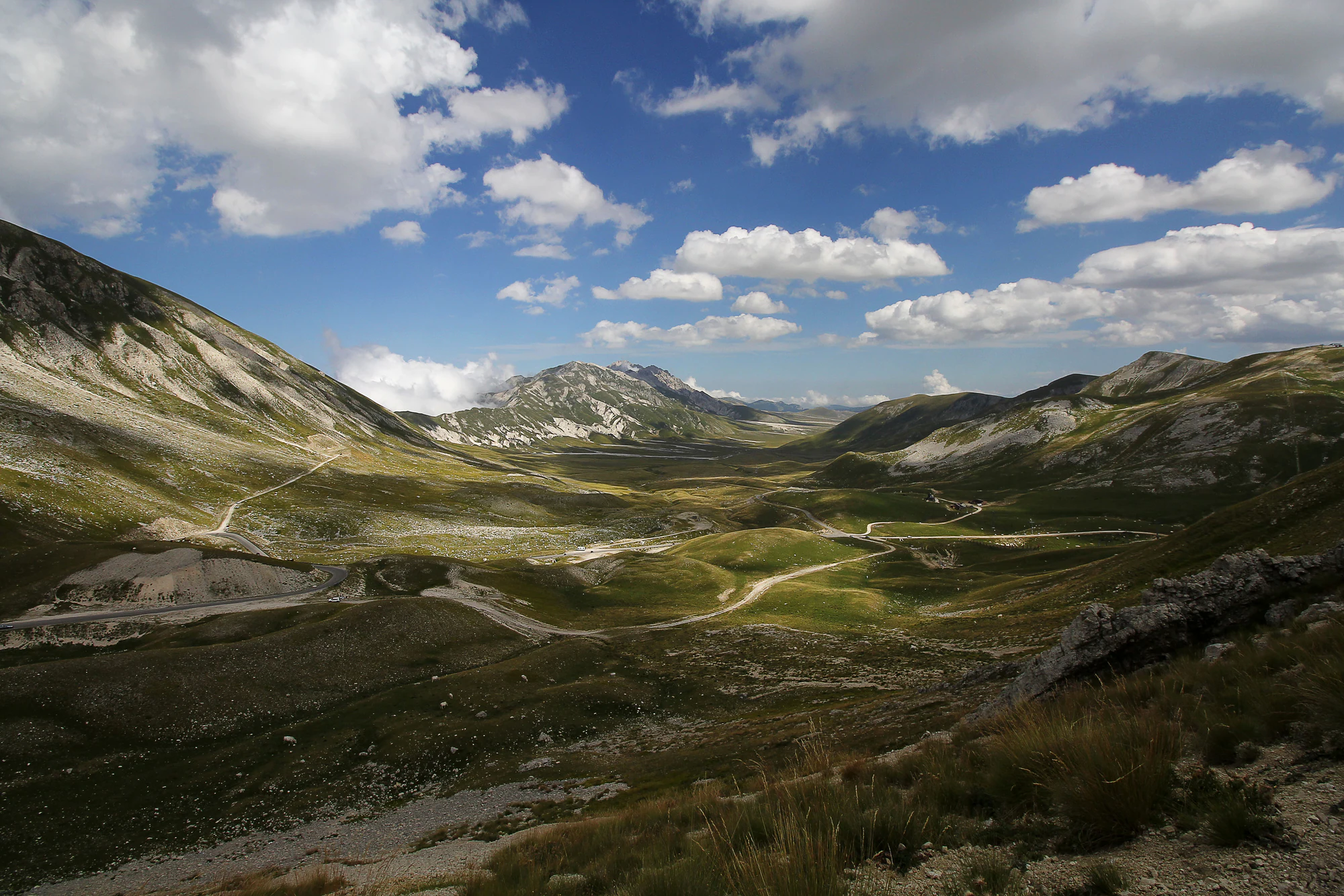
A broad grassy mountain valley between pale rocky slopes, with winding roads and a partly cloudy blue sky.

The valley toward Campo Imperatore, photographed on 21 August 2016. The roads in this historical view do not establish current access.

“Campo imperatore vallata.jpg” — Valentina Mariani, via Wikimedia Commons. CC BY-SA 4.0. Unmodified offered original. · Creative Commons

Walks and routes

Campo Imperatore to Rifugio Duca degli Abruzzi

The refuge operator describes an ascent from the Campo Imperatore forecourt along the broad gravel path beside the observatory, then left at the fork and up the bends to the crest. Its published figures are 260 metres of ascent and 40 minutes one way, with a T (tourist) grade. Allow extra time for the descent and a pause at the refuge. Read the refuge’s access description.

Loose gravel, climbing and high-altitude exposure make this unsuitable as a step-free outing. Choose calm, clear conditions.


Campo Imperatore to Rifugio Duca degli Abruzzi

Ceppo to Cascata della Morricana and back

CAI Pescara’s published route is 16 kilometres return, about five hours, graded E (hiking). It starts in the Ceppo camping area, follows a forest track for much of the outward journey, then changes to a narrower waymarked path through beech woods to the waterfall. Return by the same way. CAI reports 240 metres of elevation difference; budget effort for the final section’s repeated ups and downs as well. Read the CAI route description.

This is a long walking day, with uneven ground and stream crossings. For a shorter visit, turn back on the initial forest track before the narrower path; that does not include the waterfall and is not a verified wheelchair route.

Ceppo to Cascata della Morricana and back

Macchia da Sole to Castel Manfrino

The park’s Valle Castellana itinerary identifies a short walk from Macchia da Sole to the ruins of Castel Manfrino, perched between the Salinello and Fosso del Lago. It is a useful history-and-landscape choice if you do not want a high summit day. Ask locally for the current path advice and allow time to enjoy the setting. The approaches from down in the gorge are different walks. Read the park itinerary.

Expect an outdoor path in a rocky setting. Confirm gradients and barriers if you need a step-free option.

Macchia da Sole to Castel Manfrino

One southern-side day

With suitable weather and road access, spend the morning taking in Campo Imperatore, adding the refuge approach only if it fits your ability and conditions. Leave the afternoon for one southern village and a meal. If the mountains are clouded in, give the villages more time instead of driving between viewpoints with nothing to see.

A second day with a different landscape

Choose a Laga forest day from Ceppo, using the full Morricana route only if everyone is comfortable with its length. Alternatively, explore the Monti Gemelli side around Macchia da Sole. Plan accommodation and driving around your chosen pair of areas; these are separate day choices, not one continuous walking route.

Things to try

Campo Imperatore: space, light and high mountains

Choose the southern side for open grassland and long views. The plateau’s rolling ground, gravel fans and old glacial deposits are worth slowing down for before considering a climb. Reach it only on roads confirmed open, park in permitted places and keep vehicles off the grass. A scenic visit with a short walk can be satisfying on its own; the high refuge approach below is an optional step up in effort.

Ceppo and the Laga: forest and falling water

Make Ceppo your starting point for the Bosco Martese and the Morricana walk. The Laga’s rock keeps water near the surface, and the woodland gives you shade and a more enclosed landscape. Save this for a separate outing from Campo Imperatore. Wet conditions can make the final path and stream crossings awkward, even when the first forest track feels straightforward.

Monti Gemelli: limestone gorges and a castle approach

On the north-eastern side, the Salinello separates the Montagna dei Fiori and Montagna di Campli. Macchia da Sole offers the approach to the ruins of Castel Manfrino described below. Choose it for a combination of mountain scenery and history. Routes down into the Salinello are a different undertaking, requiring advice on water levels, exposure and local restrictions.

Southern villages and the Tirino: a gentler-paced day

Use Santo Stefano di Sessanio, Calascio or Castel del Monte for a village-focused visit, choosing one or two rather than rushing through a checklist. Local lentils and Canestrato cheese tell part of the farming story. For a different landscape, the Tirino valley lies below the high mountains, fed by springs at their southern foot. Check village slopes and individual attraction access when planning for limited mobility.

When the mountains disappear into cloud

Choose a village meal or a confirmed indoor cultural visit instead of moving the same mountain plan into a wet gorge or beneath trees in a storm. Call a museum before making a special trip. If roads or weather warnings are poor, keeping the day local is the better alternative.

Wildlife and habitats

Golden eagle

Golden eagle is recorded as a breeding bird in the park’s atlas. Its prey includes medium-sized mammals and birds. Find a quiet stopping place to scan the open sky with binoculars, giving any nesting cliffs a wide berth; sightings take patience and luck.

Alpine chough

The yellow bill, black plumage and red-orange legs are helpful identification clues. The park associates this agile bird with high mountain country and rocky nesting habitat. Watch without offering food, even if birds appear comfortable around people.

Apennine wolf

The Apennine wolf is part of the park’s wild mammal community. Its relationships with prey, livestock and free-roaming dogs are important conservation themes here. Sightings are unpredictable. Give any animal plenty of space and never seek out dens or use food or calls to attract it.

European beech

Beech shapes the park’s mountain woods, sometimes forming nearly pure stands and elsewhere growing with trees such as yew and holly. In parts of the Laga it also mixes with silver fir. The canopy and autumn colour give these walks a very different feel from the open plateau.

Stories and discoveries

The return of the Apennine chamois

The park’s emblematic chamois returned through a reintroduction programme after disappearing from Gran Sasso around the end of the nineteenth century. It is the Apennine chamois, Rupicapra pyrenaica ornata, distinct from the Alpine chamois. Seeing one should be a quiet, distant encounter: stay on the path and give it room to keep feeding or resting.

Calderone: ice as an archive

The Calderone is also a place of climate research. In 2022, the Ice Memory team recovered a deep ice core from what CNR described as a glacio-nevato, or residual ice-and-snow body. Its layers can preserve clues to the mountain’s environmental past. The high basin requires specialist mountain planning; enjoy the story without making it a casual detour.

When to visit

Spring: water and lower paths

The Laga’s streams can be lively, but the Morricana approach may be muddy and slippery. Stay away from water-polished rock edges and do not cross a stream that looks unsafe. Snow can remain higher up while the villages already feel springlike.

Summer: the main high-walking season

Choose a settled day for exposed ground and start with enough time to return well before conditions deteriorate. On Campo Imperatore, shade is limited and the open landscape offers little protection from wind. Check the mountain forecast, not just a warm valley temperature.

Autumn and winter: change the ambition

Autumn suits woodland colour and village time, with shorter daylight and seasonal services to consider. When snow or ice arrives, use local professional advice to choose an appropriate outing. Summer route descriptions and difficulty labels are not winter instructions.

Getting there and practical advice

Current access check: 19 October 2026

The Campo Imperatore lift operator’s homepage showed the cable car closed, while its notice announced maintenance from 21 September 2026. Confirm a reopening directly before relying on it. The park’s museum directory also marked facilities including the Museo del Fiore, Museo del Camoscio and Museo dell’Alpinismo as closed. Do not plan on them without direct confirmation. Road and trail conditions still need separate checks.

Food, toilets and overnight stops

Buy supplies in your chosen gateway before heading into the mountains. Rifugio Duca degli Abruzzi advertises meals and overnight stays during its published June–September season, with reservations through its website. Confirm services for your date. The Campo Imperatore operator also posted summer 2026 hostel and forecourt works, so check the exact parking, toilet and accommodation arrangements rather than assuming the high station offers everything you need.

Choose the gateway before setting off

From Rome, the park lists the A24 exit at Assergi for the L’Aquila side and Colledara/San Gabriele for the Teramo side. From the Adriatic, approaches differ for Teramo, Pescara and Ascoli Piceno. Enter your actual village or trailhead into your planning, not simply the park’s name. Mountain roads can be slow, seasonal or restricted, so check the final approach before departure.

Public transport needs a complete return plan

The park points visitors to TUA for Abruzzo, START for the Ascoli area and Cotral for the Rieti side. Services to towns do not automatically reach trailheads. Before committing to a car-free walk, confirm the last connection, weekend service and the journey back from the exact starting point. Use the park’s transport contacts.

Planning an assisted outing

The park’s Joëlette information page lists Esperienza Natura, GAIA and the CAI sections of Arsita and Castelli. Ask about the chosen trail, transfers, helpers, seating needs and accessible toilets before booking. These outings need trained assistance; they do not establish independent wheelchair access.

Sources and useful links

Wildlife you might spot

4

Each card links to a full Explore page with photos, traits, and fun facts.

Snap map for this place

Start with the big picture, then zoom in to explore individual wildlife observations around this place.

Loading map…

Good to know before you go

Carry your own drinking water, food, a warm layer, waterproofs and an offline map. Do not rely on a seasonal refuge or a spring for supplies.

Keep to established paths. Leave flowers, rocks and insects where they are, and take all litter back with you.

Give grazing animals plenty of room. If livestock or working dogs block the way, stop and seek the shepherd’s guidance rather than pushing through.

Use binoculars for wildlife. Never feed animals, play calls, approach nests or follow an animal that moves away from you.

Check the forecast and local advice before setting out; shorten the day if wind, visibility, water levels or daylight are less favourable than expected.

Frequently asked questions

Absolutely. Campo Imperatore viewpoints, a village-based day or a woodland walk can be the whole visit. Corno Grande is a separate, demanding mountain objective; proximity to a road or cable-car station does not make its summit an easy add-on. Get route-specific advice from a qualified mountain guide if it is your goal.
No. The Fonte Cerreto–Campo Imperatore cable car serves one part of Gran Sasso. It does not take you to the Laga or the Monti Gemelli. Check the dated lift warning above and confirm reopening before building a day around it.
Choose the outing around the child’s experience, not just their age. A short return walk on a suitable lower path or a village visit gives you more flexibility than a summit. Morricana’s published 16-kilometre return route is a substantial day, and its stream crossings can be slippery. The refuge approach still involves climbing at altitude.
Check dog access for the exact route with the park or your guide; do not assume all protected habitats admit pets. Where permitted, keep your dog close and under control, away from wildlife and flocks. The park prohibits unrestricted wild camping and bivouacking; its designated camping arrangements require the relevant municipality’s written authorisation. Arrange an established campsite in advance.
There is no single booking that covers these dispersed visits. Confirm each paid service separately: lifts, guided outings, accommodation and any cultural attraction. Book a refuge bed before planning to stay. The published summer 2026 ordinary return cable-car fare was €16.50; reconfirm both operation and the applicable tariff for your date.

Recent snaps at this place

Recent snaps will appear here as new observations are added.

View all ›

Take the discovery with you

Exploring Gran Sasso and Monti della Laga National Park?

Identify the wildlife you spot, learn as you go, and keep a collection of the adventure.

  1. 1Spot it
  2. 2Snap it
  3. 3Keep the discovery