Snappit logo
Snappit
Get App
Generic illustration, not a photograph of this venueIllustration
ParkCanary Islands, Spain

Caldera de Taburiente National Park

The first thing to understand about Caldera de Taburiente is its scale.

About

The first thing to understand about Caldera de Taburiente is its scale. Pine trees spread across steep folds of land, rock walls rise behind them, and the gullies keep dividing until the view feels three-dimensional. This is the mountainous heart of La Palma, in the Canary Islands. Volcanic construction, major landslides and the long work of running water all helped shape it; the bowl-like outline is only the beginning of the geological story.

For a first visit, make two separate stops. Start at the national park's visitor centre in El Paso, outside the park itself, then continue by road to La Cumbrecita when access and weather allow. The centre gives you the background; the viewpoint lets you put it together in the landscape. You can simply enjoy the outlook, walk out and back towards Lomo de las Chozas, or choose the longer Circuito de los Miradores if everyone is comfortable on uneven mountain paths.

Agree on the shortest option that everyone will enjoy, and treat any extension as optional. The routes down into the caldera, its waterfalls and its high summit rim are separate mountain outings. They need their own planning rather than being squeezed into spare time after the viewpoint. Don't forget to bring the Snappit nature identification app along to scan local species.

Long before the national park existed, the caldera formed the territory of Aceró, associated with the Indigenous Benahoarita people and their leader Tanausú. Grazing, water and the sheltered interior gave this rugged country practical and cultural importance. The park's interpretation describes Aceró's resistance during the Castilian conquest and Tanausú's capture, giving the landscape a human dimension beyond its scenery. In later centuries, water from the caldera became especially valuable to agriculture, including the sugar economy of the west of the island. Forest resources were used for timber, fuel and pitch. National-park protection followed in 1954, with reclassification in 1981. Today's visit sits within that longer story of people depending on the mountain's water and vegetation while trying to protect them.

What to do here

Begin with the displays and labelled plants at El Paso, ask staff about that day's conditions, and choose your La Cumbrecita stop accordingly. Once there, spend a few quiet minutes looking across the ridges before deciding whether to walk.

Seasonal info

Cloud, wind, rain, heat and calima can change the outing, and fire danger can restrict access. Winter conditions on the highest rim are more severe than at La Cumbrecita. Keep the centre-only option in mind when mountain conditions are poor.

Accessibility

The visitor centre and a viewpoint-based visit are the starting options for people with limited mobility. Ask about current step-free access and suitable viewing positions. The gentler Lomo de las Chozas track differs from the full circuit, which has narrow paths, bridges and a climbing return.

Don't miss

1

Look across a landscape shaped by volcanism and erosion from La Cumbrecita.

2

Choose a gentle out-and-back walk towards Lomo de las Chozas.

3

Use the El Paso displays and teaching garden to recognise island habitats.

4

For confident walkers, link the viewpoints on the 3 km Circuito de los Miradores.

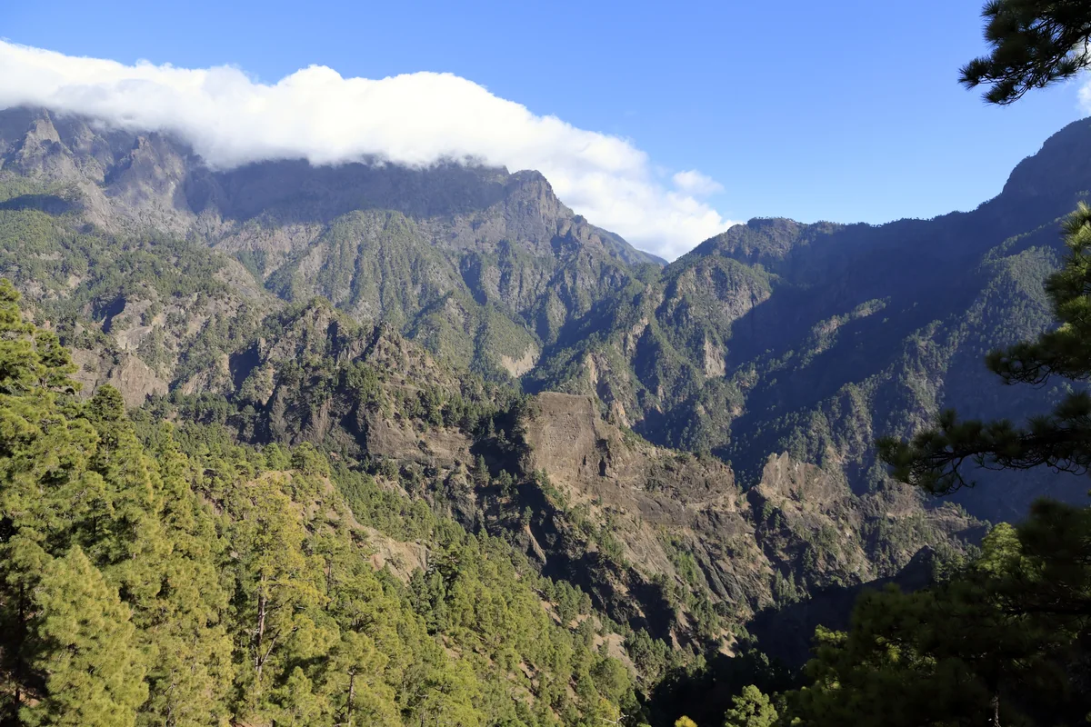
Steep pine-covered caldera walls and rock ridges beneath low cloud.

The caldera viewed towards La Cumbrecita from Lomo de Tagasaste in February 2012. This is wider-park context, not the view from the recommended La Cumbrecita stop.

I08 868 Caldera, Cumbrecita.jpg — Falk2 / Wikimedia Commons / CC BY-SA 4.0 · Creative Commons

Walks and routes

La Cumbrecita: enjoy the viewpoint

Stay around the designated viewing area and let your eyes follow the succession of ridges into the basin. This is the least walking-intensive choice. Give yourself permission to keep the visit brief if cloud hides the landscape.

Ask about the surface from your parking space and the most suitable viewing position. Mobility parking is available under the park's eligibility rules.


La Cumbrecita: enjoy the viewpoint

La Cumbrecita to Lomo de las Chozas and back

Follow the forest track to Lomo de las Chozas, then retrace your steps. This avoids the narrower lower section of the full circuit. The park describes the first kilometre as practically level, and benches provide places to pause. Turn back earlier if that is enough for your group.

A comparatively gentle mountain track, rather than a certified accessible trail. Ask about loose surfaces, current damage and suitability for a wheelchair or pushchair.

La Cumbrecita to Lomo de las Chozas and back

Circuito de los Miradores

After the forest-track approach and Lomo de las Chozas, the route follows a narrower path across small gullies and wooden bridges towards Los Roques. The final stone-paved zigzag climbs back to La Cumbrecita. Its official difficulty is low, but the terrain calls for more care than a level park path.

The complete circuit is not a step-free or straightforward pushchair route. Keep children close and avoid it if exposure or balance is a concern.

Circuito de los Miradores

A flexible first visit

About 3–4 hours, plus travel from your accommodation.

Spend roughly 45–60 minutes at El Paso. Check conditions and decide your walking limit before driving uphill.

Travel to La Cumbrecita with your permit ready, allowing time for the winding road and control point.

Enjoy the viewpoint, then choose either the Lomo de las Chozas return or the full circuit. They share the opening section, so you do not need to do both.

Return to your vehicle before your parking slot ends. Shorten the walk if anyone is tired rather than rushing.

A gentler centre-and-viewpoint visit

About 2–3 hours, with the option to stop after the centre.

Focus on the exhibits and garden, taking breaks as needed.

Ask whether the road and viewing area suit the weather and your mobility needs.

If conditions are suitable, make La Cumbrecita a viewing stop without an onward trail. Otherwise, save the mountain visit for a better day.

Things to try

Read the landscape before you walk

At the centre, choose a question to take outside: how did water cut these ravines, why do pines dominate, or how have people used the caldera? Matching an exhibit to a real feature makes the viewpoint stop more engaging.

Make a small family field notebook

From an authorised path, sketch one ridge, one tree and one cloud shape. Notice what changes when the sun moves. Collect drawings and photographs rather than cones, stones or plants, and keep the activity away from path edges.

Pause for birds

Bring binoculars if you have them, stand where you will not block the path, and listen before scanning the trees and sky. Let animals decide whether to come into view; quiet attention works better than chasing a sighting.

Explore the teaching garden

The labelled garden at El Paso introduces plants from different island habitats. These are cultivated displays: a plant seen here is not automatically one you will find along the La Cumbrecita walk.

Let El Paso be the whole visit

If the centre is open and travel there is safe, spend longer with the exhibits and ask about a film. If warnings affect roads or facilities too, postpone the trip. An indoor option is useful only when you can reach it safely.

Wildlife and habitats

Pine

The characteristic tree here is the Canary Island pine (Pinus canariensis), one member of the wider pine genus. Notice its bark and the way the woodland occupies steep ground.

Common Raven

Watch the open sky and distant rock faces from the path or viewpoint. Ravens inhabit the caldera's rocky landscape; binoculars help with a distant bird.

Eurasian Kestrel

Scan open air above the slopes during a quiet viewpoint stop. Kestrels are among the park's birds of prey, so leave time to watch the sky as well as the landscape.

European Robin

Pause to listen in a sheltered, vegetated stretch. The park includes robins among birds associated with ravines and watercourses; staff can advise what has been noticeable recently.

Common Blackbird

Listen as well as look along vegetated sections. Blackbirds are part of the park's stream and ravine birdlife; a quieter patch can be a good place to pause.

The park's wildlife occupies a wide range of habitats, and a short La Cumbrecita visit explores only a small part of them. Enjoy whatever you encounter, avoid disturbance and never seek out nests or leave the path for a closer view.

Stories and discoveries

A bowl with a complicated origin

The caldera is often imagined as a simple volcanic crater. Its present form also reflects major landslides and erosion. The deeply cut ravines show why moving water belongs in the explanation.

Pines with a survival strategy

Canary Island pine has thick bark that helps it withstand fire. That resilience does not make fires harmless: undergrowth, wildlife and people remain vulnerable, and lighting a fire in the park is prohibited.

Clouds change with height

Middle elevations frequently encounter banks of cloud, while the highest summits can experience snow and ice in winter. Sunshine beside the sea does not tell you what the mountain paths will be like.

Water shaped livelihoods too

The caldera's springs and water use have long supported agriculture beyond its walls. This helps explain why an apparently wild mountain landscape has mattered so much to surrounding communities.

When to visit

Clear, mild weather

Make the viewpoint the centrepiece and choose your walk after checking the forecast. Keep a layer handy: the mountain can move in and out of cloud while you are there.

Hot or hazy conditions

Shorten plans during heat or calima, carry enough water and follow fire-related restrictions. A pine canopy is no reason to ignore a warning. Choose the centre if walking would be uncomfortable.

Rain, wind or winter weather

Postpone exposed walking if conditions deteriorate. Rockfall and temporary closures are mountain hazards. The high summit rim is a different, colder outing, and a poor casual alternative when the lower visit is clouded in.

Getting there and practical advice

El Paso visitor centre

Find it at Carretera General de Padrón, 47, El Paso. It has reception and information, exhibitions, a library, audiovisual interpretation and an outdoor teaching garden. The park's 2023 inventory also lists toilets and parking. Ask about toilet availability before continuing uphill.

Published opening hours

The regional park website lists daily opening 09:00–18:00 from 22 February to 31 October and 09:00–16:45 from 1 November to 21 February. On 24, 25 and 31 December, 1 January and Los Indianos Monday it lists 09:00–15:00. Confirm holiday changes before travelling; all times are local Canary Islands time.

Film screenings

Ask reception which screening is available in your language. Organised groups wanting a particular time should arrange an audiovisual reservation; the film lasts approximately 19 minutes. This reservation is separate from La Cumbrecita parking.

At La Cumbrecita

There is a small parking area and a visitor-information point. Bring drinking water and food rather than depending on refreshments or a refill. Ask about toilets at El Paso: do not plan around finding them on the circuit.

Contact the park

For access, facilities and route advice, call +34 922 922 280 or email [email protected]. Describe your intended walk and any mobility needs so staff can give useful advice.

Drive from the El Paso gateway

From the visitor centre, take the LP-302 towards La Cumbrecita. The park describes about 7 km of road between them. Use designated parking; a roadside space is not a substitute for the required permit.

Book parking before the drive

Vehicle access is controlled from 08:30 to 16:00, with an extension to 18:00 possible during busier periods. Check the arrangement for your date rather than assuming 16:00 means unrestricted access. Reservations open up to one month ahead and may remain available on the day.

Use the permit carefully

Show your own permit at El Riachuelo; a phone copy is accepted. The arrival window runs from 10 minutes before to 20 minutes after the start of your slot. Cancel an unused booking by the end of the previous day. Published conditions warn of a one-year booking restriction for an uncancelled no-show, late arrival or overstaying, with an adverse-weather exception. Read the current terms when booking.

Public transport reaches the centre

The park lists TILP line 300 between Santa Cruz de La Palma and Los Llanos de Aridane as stopping at the centre. Check the operator's timetable and return journey. La Cumbrecita's organised-group coach arrangements are not a regular public bus service; arrange a suitable onward transfer separately if you are travelling without a car.

Ask about the centre first

MITECO describes facilities helping visitors with reduced mobility access the El Paso centre. Confirm the current step-free route, toilet access and usable exhibition areas. Different parts of the building and garden may have different access.

Mobility parking at La Cumbrecita

The park publishes a reservation exemption for visitors with qualifying reduced-mobility documentation, shown at the control point. Ask which document and arrangements apply to you. This exemption does not override a safety closure or establish trail accessibility.

Match the path to your needs

For a wheelchair, walking aid, pushchair or difficulty with heights, describe your needs to staff rather than relying on a low-difficulty label. A forest track, a viewpoint approach and the narrow-path circuit are different access questions.

Check conditions before leaving El Paso

On 16 October 2026, the official status card for the Circuito de los Miradores displayed “trail open”. Conditions can change quickly: check current trail information, park notices and the AEMET mountain forecast again before your visit. Follow staff instructions and closure signs even with a valid permit.

Keep this outing above the interior

Do not follow an inviting downhill branch into the caldera as an improvised shortcut or extra. The interior has longer routes and ravines, and getting back out is a substantial part of the day. This short outing returns to the same parking area.

Sources and useful links

Wildlife you might spot

5

Each card links to a full Explore page with photos, traits, and fun facts.

Snap map for this place

Start with the big picture, then zoom in to explore individual wildlife observations around this place.

Loading map…

Good to know before you go

Reserve the correct La Cumbrecita parking slot before setting off; save the permit on your phone and keep to its arrival and departure times.

Check the official trail status and mountain forecast on the day. A reservation never overrides a closure or an instruction at the barrier.

Wear shoes with grip and bring layers, sun protection, drinking water and a snack. Leave enough daylight to return without rushing.

With children, choose your turnaround point early and keep close control near steep ground. There is no need to finish a circuit to have a good visit.

Keep to authorised paths and parking areas. Leave rocks, plants and archaeological objects where they are.

Fire and recreational drones are prohibited. Keep wildlife watching quiet and take your rubbish away.

Pets are not allowed in the park. If you travel with an assistance animal, ask the park about arrangements beforehand.

For an emergency, call 112 if you have a phone signal. Do not assume every part of this mountain landscape has coverage.

Frequently asked questions

No. It is the external information gateway for this outing. La Cumbrecita is reached separately by road. The park interior and summit rim are other sectors of the same protected destination.
Yes. Make La Cumbrecita a viewpoint stop and add only the walking that suits your group. The descent into the interior belongs on a separately planned day.
No. Safety closures can cancel access after a permit has been issued. Read current notices and follow staff instructions at El Riachuelo and La Cumbrecita.
Choose the viewpoint or discuss the first forest-track section with staff instead. The full circuit has narrow sections, bridges and an uphill stone-paved return.
Treat those as a different trip, with their own access, transport and mountain-walking arrangements. Ask the park for suitable routes and current conditions before committing.
Enjoy the visitor centre and ask whether a mountain visit is worthwhile. Do not extend a walk into worse weather to try to get below or beyond the cloud.

Recent snaps at this place

Recent snaps will appear here as new observations are added.

View all ›

Take the discovery with you

Exploring Caldera de Taburiente National Park?

Identify the wildlife you spot, learn as you go, and keep a collection of the adventure.

  1. 1Spot it
  2. 2Snap it
  3. 3Keep the discovery