
Snappit logo
Snappit
Get App
Generic illustration, not a photograph of this venueIllustration
ParkFR

Marais Poitevin Regional Nature Park

The Marais poitevin changes character as you cross it.

About

The Marais poitevin changes character as you cross it. In the eastern wet marsh, small channels thread between trees, gardens and meadows. Farther west, the drained marsh opens into broad agricultural landscapes structured by ditches and dikes. At the coast, the horizon belongs to tidal habitats and waterbirds. The famous green waterways are one face of a much larger regional nature park.

For a first visit, choose Arçais in Deux-Sèvres. Its Grand Port was a working link between the surrounding farmland and the Sèvre Niortaise navigation network. Looking from the street toward the water, you can begin to understand why homes, storage buildings and landing places were arranged as they were. This gives children something concrete to explore before asking them to sit quietly in a boat.

A morning here is deliberately a small-scale introduction. Save the western marshes and coast for another outing rather than turning the day into a drive between disconnected stops. A village walk and a boat journey also reveal different things: the first shows how people lived beside the water; the second takes you into channels that a footpath cannot follow. Eager to name that creature? Identify any animal you find during your visit using the Snappit app.

This landscape grew out of the former Golfe des Pictons and centuries of engineering. Medieval drainage projects protected farmland with dikes and channels; later work developed navigation and the wet-marsh network. Water management did not simply remove water everywhere. It created different landscapes with different jobs, including land that still receives floodwater. Arçais makes that history tangible. The large house, or logis, beside the port stands above former warehouses used for goods moving toward Niort and Marans. The wooden lifting structures recall the handling of timber. Think of the port as the village’s old freight yard: it helps explain why apparently quiet canals once carried so much everyday activity.

What to do here

Begin with the official Arçais village-discovery walk described below. Use its online stages to connect the houses, waterside lanes and port, then take a proper break. If you want to continue, a separately booked guided trip in a flat-bottomed barque is the simplest way to explore beyond the village without having to navigate the channel network yourself. Give the batelier, or boat guide, time to explain water management as well as wildlife: both are essential to understanding this place.

Seasonal info

Water levels matter more than the calendar. Winter and prolonged rain can inundate low ground, while summer heat makes drinking water and shade important. Check local conditions before setting off, especially after heavy rain or strong wind.

Accessibility

The short distance does not make the full Arçais route step-free: its official description warns of a very steep lane. If gradients or waterside surfaces are a concern, arrange a suitable village visit with the tourist office before travelling.

Don't miss

1

Arçais’s Grand Port and its reminders of trade by water

2

Houses with a relationship to both the village street and the canal

3

A short interpretation walk that does not require hiring a boat

4

The contrast between wooded wet marsh, open drained marsh and coast

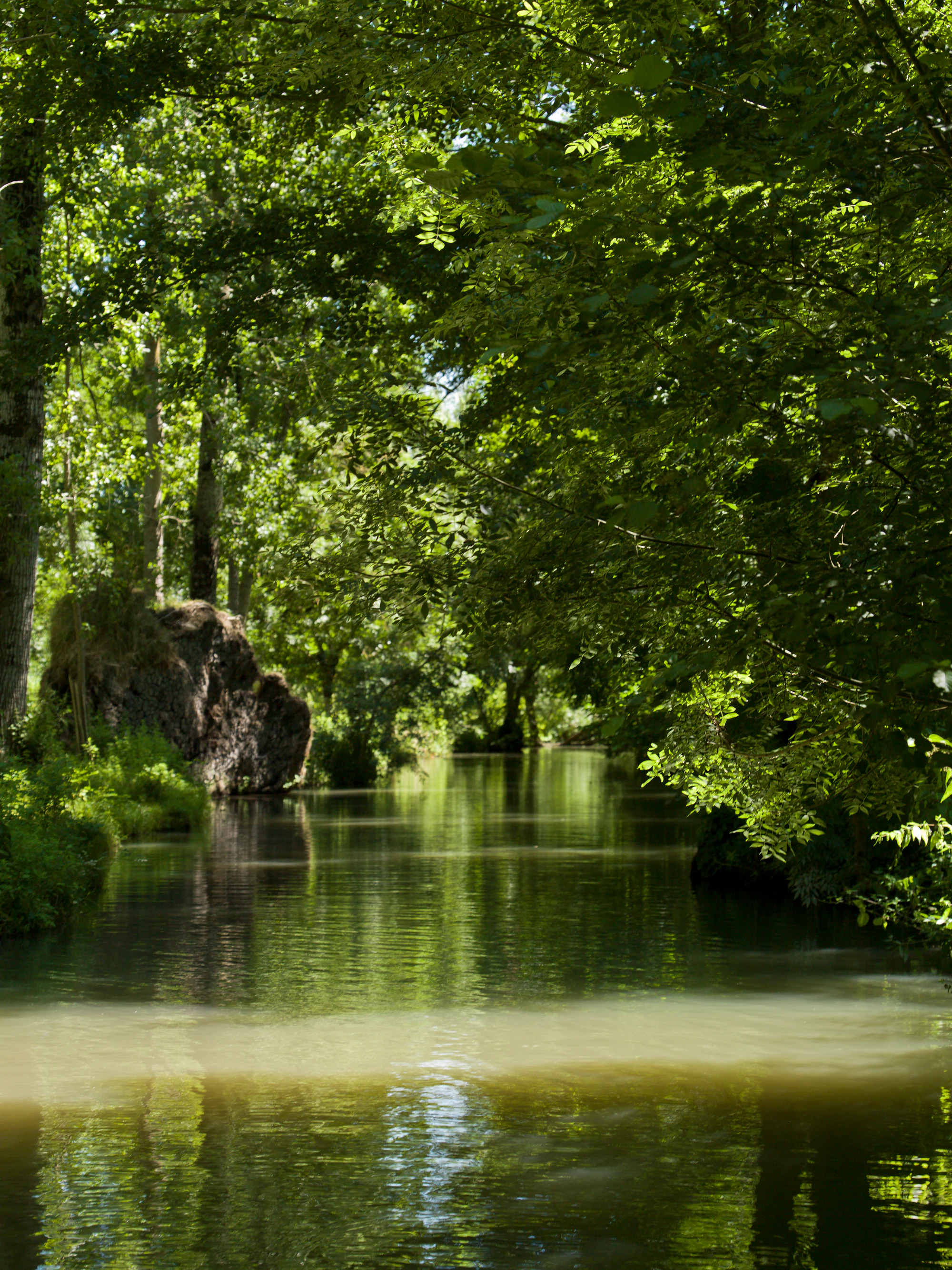
Trees arch over a narrow canal, with dense green foliage, reflections on the water and a pale band of sunlight in the foreground.

A leafy canal in the Marais poitevin’s Venise verte, photographed in August 2016. The exact canal is unidentified, so use this as wet-marsh context rather than a guide to the Arçais route, embarkation points or present-day water conditions.

“Le marais poitevin la Venise verte-2-cliche Jean Weber-1” — Inra, DIST, Jean Weber, CC BY 2.0. Source: https://www.flickr.com/photos/inra_dist/25311027018/. License: https://creativecommons.org/licenses/by/2.0/. Original photograph unchanged. · Creative Commons

Walks and routes

Arçais – Découverte d’un village maraichin

The tourist office publishes this 1.5 km walk with a one-hour duration. It begins at the church and finishes at the tourist office. Follow the official numbered stages through the village and beside the canal. The itinerary is unmarked; keep the route page to hand rather than improvising connections between waterside paths.

Stage 6 descends a very steep lane. Assess that section before committing to it; the “very easy” walking grade is not an accessibility assessment.


Arçais – Découverte d’un village maraichin

A first morning in Arçais

Arrive with the route saved and your return journey settled. Walk the village-discovery itinerary at the pace of the slowest person, leaving time at the port to make sense of the buildings and water. Finish with a drink or your own snack. This is a complete outing in itself; there is no need to add a boat just to make the visit feel worthwhile.

A half-day with time on the water

Reserve a guided boat first, then fit the walk and lunch around the confirmed departure. Leave a generous gap for finding the embarkation point and the safety briefing. If a boat is cancelled, keep the village outing only if conditions there remain safe. Do not replace a cancelled guided trip with an improvised self-guided paddle.

Things to try

Add a guided barque outing

Bardet-Huttiers offers a one-hour “tradition” circuit and longer guided outings from Arçais. Choose the short trip if this is your family’s first boat excursion, and book it separately from the walk. The operator’s main season is April–October; contact it directly for late-season or off-season plans. Confirm the boat and meeting point before paying. A canal trip is still an on-water activity: wear the supplied correctly fitted lifejacket, remain seated as instructed and let the batelier decide whether conditions are suitable.

Read the port like a working landscape

At the Grand Port, ask everyone to identify one feature that would have helped move or store goods. Look at the lifting structures, warehouses and landing area from public space, then compare them with the smaller waterside homes. It is a useful little investigation even when the birds remain hidden. The logis is private, so enjoy the view without treating doorways or gardens as part of the route.

Check the museum before making a rainy-day detour

The Maison du Marais poitevin is in Coulon, separately from this walk. Its operator announces closure on 1 November 2026 for renovation, with reopening planned for late 2028. Confirm final admissions if visiting around the closure date, and do not rely on it as an indoor fallback during the works. In heavy rain or strong wind, postponing the outdoor outing is the simplest option.

Wildlife and habitats

Grey heron

Look for a tall grey bird with long legs and a pointed bill. A heron in flight folds its neck back while its legs trail behind. On the ground, apparent stillness may be hunting concentration: watch for the sudden movement that follows. Grey herons are documented in the park’s wet woodlands and official atlas.

Common kingfisher

A kingfisher may first register as a quick flash low over the water. Blue-green upperparts, orange underparts and a sharp call are useful clues. The official atlas includes records from Arçais, although an individual can be easy to miss. Watch a clear stretch of channel from the path and let the bird come into view.

Black-crowned night heron

This smaller heron is included in the park’s spring-and-summer bird list and wet-woodland guide. Low branches over the water are part of its habitat. Shaded cover can make it difficult to see, so binoculars and an unhurried look are more useful than trying to enter the vegetation.

Eurasian otter

The otter never disappeared entirely from the Marais poitevin, making the wetland an important refuge. Its diet includes fish, amphibians and crayfish, and monitoring often relies on droppings rather than direct sightings. A daytime visitor is unlikely to meet this discreet animal. Undisturbed banks and connected waterways matter far more to it than a clear view for a camera.

Stories and discoveries

The trees have a working history

The round-headed trees called têtards owe their shape to repeated cutting, traditionally producing wood. Their sculptural outlines are evidence of management, rather than an unusual natural species. Some wooded plots also developed from narrow raised strips created beside excavated ditches. Looking for that connection between a tree, a channel and a parcel of land makes the green scenery easier to read.

The familiar canopy is changing

Ash dieback threatens the characteristic tree lines. The park is helping maintain existing trees and plant replacements using a wider choice of species. Young rows and uneven canopies can therefore be part of conservation work, rather than evidence that the landscape has simply been neglected. Give tree-work areas plenty of room.

Wet marsh has a hydrological purpose

The marais mouillé is a floodplain. Meadows, ditches and wooded ground can hold water during wet periods, while the drained-marsh landscape relies on a different system of dikes and channels. A green summer photograph can hide this seasonal transformation. Respecting a flooded-path closure is part of visiting the landscape as it actually functions.

When to visit

Spring: a good time to choose a modest plan

Trees and marsh vegetation make the eastern waterways an attractive spring outing, and bird activity adds interest. Keep a flexible date if recent rain has left the ground saturated. Book an activity for its explanation of the habitat, rather than expecting a particular animal to appear on cue.

Summer: keep time between activities

On hot days, prioritise the walk earlier and carry water for the whole group. A shaded-looking boat photograph does not tell you how exposed the waiting area or every stretch of the trip will be. Sun protection and a light extra layer are useful choices; avoid scheduling a long walk immediately before a fixed departure.

Autumn and winter: choose the right part of the park

Migrating and wintering birds give the wider park a different appeal, especially in open and coastal habitats. That is a separate excursion from this wooded village focus and needs its own access and weather planning. For Arçais, check flood information and local advice after rain, and expect fewer staffed visitor services.

Getting there and practical advice

Plan around village services

Arçais has a tourist information bureau and places for refreshments, but staffing and opening are seasonal. Bring what you need if arriving early or outside the main visitor months. Ask locally about the nearest open toilet and drinking-water refill before setting off; a private operator’s facilities should not be assumed available to everyone.

Walking and paid activities

Use the public village route as the basis of your visit. Boat fares, refreshments and other paid activities are separate. Compare the complete price for your party and the actual time on the water, rather than choosing from a headline “from” price. Check parking signs on arrival and keep streets and working access clear.

Train to Niort, then check line 21

Niort is the practical rail gateway for this focus. Tanlib line 21 links Niort with the Arçais Écoles stop; the published route includes Gare SNCF. Check the current timetable for your exact date, school-holiday pattern and return, plus traffic notices. Do not build a boat booking around an assumed frequent service. Leave time to walk from the stop to your starting point.

Arriving by car

Navigate to Arçais village, not simply to “Parc naturel régional du Marais poitevin”, which covers a large territory. Use signed visitor parking and continue on foot. If you have booked a boat, use the operator’s confirmed address: different embarkation points serve the village, and the port is not an interchangeable meeting place for all of them.

Match the outing to your mobility

Ask the tourist office for a route suited to your needs, explaining whether steep descents, steps, rough ground or narrow waterside passages are the limiting factor. Do this before arrival if an accessible toilet or parking place is essential. The compact village offers choices about how long to stay, but a shorter improvised outing should not be presented as a certified accessible circuit.

Ask specifically about Barque Noë

Bardet-Huttiers advertises an adapted Barque Noë with capacity for wheelchair users. Reserve that specific provision and check boarding, wheelchair dimensions, any transfer, companion requirements and the route to reception. The existence of an adapted craft does not establish that every boat departure or every part of the walking route is accessible.

Sources and useful links

Wildlife you might spot

4

Each card links to a full Explore page with photos, traits, and fun facts.

Snap map for this place

Start with the big picture, then zoom in to explore individual wildlife observations around this place.

Loading map…

Good to know before you go

Save the official walking page before leaving. The route is unmarked, so a familiar-looking canal is not a reliable wayfinding cue.

Bring grippy shoes, drinking water and a light waterproof. Keep a little space in the day for a break rather than filling every hour.

Supervise children closely beside water and on crossings. Keep away from moored boats, private landing stages and work equipment.

Use binoculars or a camera zoom from the path. Do not feed wildlife, play bird calls or enter bankside cover to improve a photograph.

For boating, confirm the exact departure place, fare, duration, lifejackets for every passenger and cancellation arrangements when reserving.

Keep dogs close and on a lead, respect local signs, and ask the chosen boat operator about its own pet arrangements.

Frequently asked questions

No. Arçais provides a rewarding introduction on foot. A boat adds the experience of moving through the channel network, but it is a separate activity with its own booking, weather and accessibility questions.
No. That name is associated with the wooded wet-marsh scenery. The regional park also includes open drained marsh and coastal landscapes. The Grand Site de France designation concerns the celebrated wet-marsh landscape, not the whole park perimeter.
Do not assume the complete route will suit either. Ask about the steep lane, surface condition and a usable alternative. An adapted boat can be a separate option, but the operator must confirm boarding and the specific craft for your visit.
Turn back. Do not wade, use a private garden as a bypass or assume a bridge will be reachable from the other side. Check local notices and ask the tourist office for an alternative that is open that day.
There is no single attraction-style visit here: villages, walking routes and independently operated activities are spread across a large lived-in landscape. Budget separately for any boat trip, museum, rental or guided excursion you choose.

Recent snaps at this place

Recent snaps will appear here as new observations are added.

View all ›

Take the discovery with you

Exploring Marais Poitevin Regional Nature Park?

Identify the wildlife you spot, learn as you go, and keep a collection of the adventure.

  1. 1Spot it
  2. 2Snap it
  3. 3Keep the discovery







