Snappit logo
Snappit
Get App
Generic illustration, not a photograph of this venueIllustration
ParkRegión de Murcia, Spain

Calblanque, Monte de las Cenizas and Peña del Águila Regional Park

Calblanque is easy to underestimate if you arrive thinking only about a beach.

About

Calblanque is easy to underestimate if you arrive thinking only about a beach. Behind the sand lie salt pans, dry streambeds, low scrub and wooded hills; farther west, the landscape rises towards Monte de las Cenizas and Peña del Águila. These three names belong to one regional park, stretching across Cartagena and La Unión between the Portmán and Cabo de Palos areas.

For a first visit, Las Cobaticas is a useful place to slow down. The visitor centre occupies a white, flat-roofed building in the local rural style, and its botanical interpretation area introduces native plants along a wooden boardwalk. Spend time here before deciding how much walking suits the weather and your group. A short nature visit does not have to include a swim or a summit.

The coast makes the contrasts especially clear. Pale fossil-dune rock sits near dark cliffs and living sand dunes, while the Salinas del Rasall add a shallow-water habitat behind the shore. Look from authorised paths: what appears to be an empty patch of sand can hold fragile plants or nesting birds. The protected fossil-dune formation is for looking at from the permitted route, not scrambling over.

If you want a longer outing, choose it deliberately. The Cabezo de la Fuente circuit combines rural tracks with a rougher coastal section; the Monte de las Cenizas walk climbs through woodland to a former coastal battery. Neither is a small extension to the botanical boardwalk. Take one as the main activity, keep time for the return and save the other part of the park for another day. Planning to visit? Download the Snappit app to identify the wildlife you spot in real-time.

Calblanque’s scenery also records how people used the coast. The official park leaflet describes salt working, small-scale farming, mining and a Roman road connected with the mineral resources of the surrounding hills. The Rasall salt pans remain an important wildlife habitat even though commercial salt production is no longer active. Monte de las Cenizas adds a different chapter. Its former battery, built in 1931 to help defend Cartagena’s naval arsenal, has a monumental entrance and two large guns above the coast. Enjoy the visible structures from safe, permitted ground; the abandoned military buildings are not a fitted-out visitor attraction. Protection began with a special plan in 1987, followed by regional-park designation in 1992 and a natural-resource management plan in 1995. The modern access controls are part of that continuing balance between public visits and the protection of a small, sensitive coast.

What to do here

Begin with Las Cobaticas and its botanical boardwalk, or choose one of the signed walks below. Use binoculars at an authorised Rasall viewing point, compare the colours and textures of the coast, or make Monte de las Cenizas the day’s main walk. A beach stop is optional and depends on sea conditions, access and the time you need to get back.

Seasonal info

The beach shuttle is seasonal, while other busy dates have parking-capacity controls. Storms can affect tracks and stream crossings; heat, fire danger or conservation work may change access. Bird-protection restrictions also apply around Cabezo de la Fuente. Check the current park notice and use the signed route rather than a track downloaded years ago.

Accessibility

Las Cobaticas is the strongest starting point for an accessible visit: the park’s February 2026 sheet describes a reserved parking space, ramp, accessible toilet, hearing loop and accessible botanical boardwalk with Braille panels. The dune and hill routes have different surfaces and demands. Cartagena explicitly lists Playa Calblanque as unsuitable for visitors with reduced mobility; confirm the exact journey and facilities you need with the centre.

Don't miss

1

Native-plant interpretation on the Las Cobaticas boardwalk

2

The contrast between living dunes, pale fossil-dune rock and dark coastal cliffs

3

Quiet birdwatching at Salinas del Rasall from permitted viewing places

4

Woodland, sea views and the historic battery on the Monte de las Cenizas walk

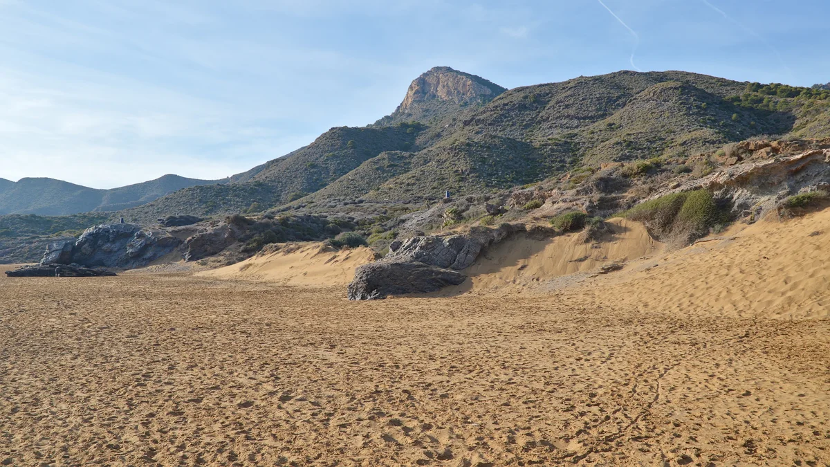
A broad sandy beach below rocky outcrops and scrub-covered hills in Calblanque.

Sand, rocky outcrops and scrub-covered hills in Calblanque Regional Park, photographed in February 2024.

Calblanque Regional Park (Parque Regional Calblanque) - Cartagena, Spain 2024-02-05 (18).jpg — Ryan Hodnett / Wikimedia Commons / CC BY-SA 4.0 · Creative Commons

Walks and routes

Las Cobaticas: centre and botanical boardwalk

Make this your short introduction. Look around the interpretation centre, then follow the wooden boardwalk through the native-plant display. Choose one or two plants to recognise later rather than trying to learn every label. Allow 45–75 minutes for the combined visit and a rest.

The 2026 access sheet identifies a ramp with a handrail, hard-surfaced entry, adapted toilet, hearing loop and accessible boardwalk with Braille panels. Ask about current maintenance and your particular mobility needs.


Las Cobaticas: centre and botanical boardwalk

Senda de la Duna Fósil: a short coastal circuit

The park map lists a 2 km circular walk starting and finishing at El Atochar. It brings you beside the protected fossil-dune landscape without requiring a long hill walk. The official moving time is 25 minutes; allow 45–60 minutes to look and pause. Reach El Atochar using the access arrangements for your date, and stay on the signed footpath throughout.

The map grades the walk as low difficulty, which is not a wheelchair-accessibility rating. Expect an exposed coastal outing; ask the centre about sand, boardwalk condition and any barriers before taking a pushchair or mobility aid.

Senda de la Duna Fósil: a short coastal circuit

Monte de las Cenizas: woodland and battery, out and back

Start at the signed PR-MU 2 approach near the junction of the Portmán–Los Belones road and the Llano del Beal road. The official leaflet describes a short roadside approach to the vehicle barrier, then a forest track uphill. Continue to the viewpoint and battery and return the same way. The published route is 3 km each way, with 166 m ascent; the park’s geology activity leaflet gives 6 km return and 2½ hours with stops. Allow up to three hours if you linger.

A sustained uphill walk on a forest track, with a roadside approach and exposed ground near the top. It is not the accessible botanical walk. Keep children close around cliffs and old military structures, and do not enter unsafe buildings.

Monte de las Cenizas: woodland and battery, out and back

Cabezo de la Fuente: the longer circular walk

This 7.8 km PR-MU 1 loop begins and ends at Las Cobaticas. The official direction runs towards La Jordana and Fuente Grande, continues by Los Huncos, then joins a rougher coastal section before returning via El Atochar. It circles the hill rather than taking you to its summit. The leaflet gives 175 m ascent and 2½ hours of walking without stops; allow 3½–4 hours for a relaxed outing.

Some tracks are shared with vehicles, while the coastal descent has irregular, eroded and rocky footing. Suitable for walkers prepared for a proper half-day route, not an all-abilities or pushchair circuit. Heat can make its modest distance feel much harder.

Cabezo de la Fuente: the longer circular walk

A gentle first hour

Arrive during Las Cobaticas opening hours, ask about today’s paths and spend time in the displays. Follow with a slow botanical-boardwalk visit and a seated break. Finish there if it is hot or anyone is tired; you have still had a worthwhile introduction to the park.

A coastal half-day

Arrange access to El Atochar first, then make the fossil-dune circuit your main walk. Add a rest or a beach stop only if conditions and return transport fit. Rasall birdwatching can be a separate stop using an authorised approach confirmed by staff, rather than an improvised connecting walk.

A walking morning in the western hills

Go directly to the PR-MU 2 start with water, a snack and the official leaflet. Take the ascent steadily, enjoy the permitted viewpoint and return by the same track. Keep the afternoon flexible instead of adding the Cabezo circuit or trying to cross the entire coast.

Things to try

A small plant-shape challenge

On the botanical boardwalk, compare a fan-shaped leaf, a needle-like leaf and a small tough-looking leaf. Use the labels or ask staff to name them. Later, notice how much lower the vegetation becomes on an exposed slope. Keep the game observational and leave leaves and flowers attached.

Watch the salt pans patiently

Ask staff which Rasall observation points and approaches are currently open. Settle in with binoculars and watch how birds move between shallow water and dry edges. Stay at the permitted viewing place rather than walking onto salt-pan banks, and do not turn a birdwatching stop into a circuit along closed tracks.

Read the coast through its rocks

Compare the pale fossil-dune material with the darker coastal rocks from the authorised path. At Monte de las Cenizas, the official Geoyincana adds prompts about rock layers and the surrounding landscape. Photograph details without removing rocks or approaching cliff edges.

Make a beach stop optional

Choose the beach sector before buying a summer bus ticket: line 1 serves the Playa Larga–Negrete side and line 2 the Calblanque–Salinas side. Keep your return time in mind. Swimming is a separate decision based on flags, currents and supervision; a sandy picnic stop is enough on an unsuitable sea day.

Keep the visit indoors, or postpone

In ordinary rain, the Las Cobaticas displays can provide a short visit if the centre and its approach are open. In heavy rain, storms or serious wind, postpone outdoor routes rather than sheltering under cliffs or crossing a flowing rambla. Check conditions before travelling; the centre should not be treated as an emergency refuge.

Wildlife and habitats

Aleppo pine

Look along the woodland route for pine needles and cones, and compare the airy canopy with the denser shrubs below. Aleppo pine is a useful starting point for understanding the Cenizas woodland; do not assume every evergreen tree is the same species.

Mediterranean fan palm

Look for compact clumps of fan-shaped leaves in the scrub. This is the palmito named on local interpretation panels. Compare the leaf outline from the path and leave the fruit for wildlife.

Mastic

Mastic is an evergreen shrub with leathery leaflets. Look at how its compact foliage contrasts with the pine needles above it; when fruits are present, they change from reddish tones to black. Observe without picking or tasting.

Sea daffodil

The park’s dune flora includes this white-flowered plant. If flowers are present, enjoy them from the boardwalk or signed path. Finding a bloom is never a reason to step through dune vegetation.

Sea holly

Look for a low coastal plant with stiff, spiny leaves and pale bluish flower heads when in season. Sea holly is part of the sandy habitat, so look from the established route and avoid touching the prickly leaves.

Black-winged stilt

Watch for slender black-and-white waders with very long reddish legs at the salt pans. Compare how far they wade with the shorter-legged birds nearby, using binoculars from a permitted viewing point.

Common shelduck

This large duck has a bold pattern: much white, a dark green head, red bill and chestnut band. If one is present, watch quietly as it moves between water and the margins; do not approach birds or search for nests.

Greater flamingo

A long neck and long legs make a flamingo’s outline distinctive even at a distance. Look for feeding movements in the shallows rather than expecting a large pink flock, and let binoculars bring the detail closer.

A place to observe quietly

The species below are documented in the park, but what you see will vary with water levels, season and luck. Watch from authorised paths and viewpoints, do not feed or approach wildlife, and leave plants intact. If you encounter a sea turtle, tracks or an injured wild animal, keep your distance and call 112; do not move it.

Stories and discoveries

Three names, one protected landscape

The long name joins the coastal Calblanque area with Monte de las Cenizas and Peña del Águila. This helps explain why a visit can range from open sand to a wooded uphill track without leaving the same regional park.

A worked landscape that still supports wildlife

The Rasall ponds reflect the area’s salt-making past. Their industrial use has ended, but their water and margins remain valuable to wildlife. Their neat shapes are a reminder that a useful habitat can also carry a human history.

Plants with a wider Mediterranean story

Cartagena cypress, Tetraclinis articulata, is one of the park’s distinctive plants. Ask staff to help you distinguish it from Aleppo pine. The very rare Cartagena rockrose is another conservation story to learn about at the centre, rather than a plant to seek out off the path.

When to visit

Mild weather: choose a longer look

Spring and autumn are useful times for a slow botanical visit or one of the longer walks. Let actual conditions decide the route: after heavy rain, postpone streambed or coastal sections if staff advise that they are flooded or damaged.

Summer: organise access before the outing

Keep exposed walking early and modest. Plan water, shade, the right beach sector and the return bus together. Do not walk a long hot access road simply because the parking area has closed; choose a shorter visit elsewhere or come back another day.

Winter: daylight and bird protection

A bright winter day can work well for the centre or a planned walk, with extra clothing for wind and enough daylight to return. The published protection period around La Fuente and El Pico runs from 15 December 2026 to 15 June 2027. Keep to the authorised circular route and check for updated signs.

Getting there and practical advice

Las Cobaticas facilities

The centre lists toilets, tables and benches, public parking, bicycle parking and visitor information. It is a useful place to ask about trails and conservation rules before setting off. Contact: +34 968 228 984 or [email protected]. Check opening if your visit depends on a toilet or staff advice.

Las Cobaticas: published 2026 hours

From 16 September to 14 June, the calendar gives Tuesday–Saturday 09:00–14:00 and 15:00–17:30, with Sundays and public holidays 09:00–14:00 and 14:30–15:30. From 15 June to 15 September, opening is Tuesday–Sunday and holidays 08:30–15:00, with an extra 16:00–17:30 session on Fridays and Saturdays. Mondays normally close. The calendar lists exceptions and extra holiday or training closures, so check your date rather than treating this summary as a guarantee.

Bring supplies and take rubbish home

Buy food and water before entering the park, for example in Los Belones, Cabo de Palos or Portmán. There are no sales points inside the park and no bins in the beach area. Carry enough for the whole outing and take food scraps, cigarette ends and other litter back out.

Seasonal beach rescue cover

Rescue cover is seasonal: Playa Calblanque’s published summer season ends on 15 September. Check whether lifeguards are on duty for your visit, and do not assume every cove has a staffed post. Use the municipal beach-status service and on-site flags; the absence of a flag or lifeguard is no reassurance about the sea.

Prepare for weak mobile reception

Save your map, tickets and important details offline. The park warns of poor beach reception and phones sometimes switching to a different time. Check the correct local time before going down to the shore, especially if you are catching the last return bus. In an emergency, try 112 and seek help from staff when available.

Arriving for Las Cobaticas

The centre’s access sheet directs drivers from exit 14 of the RM-12: after about a kilometre, take the right branch and continue roughly another kilometre. Use current signs and staff instructions, particularly during access controls. A beach shuttle is not a year-round bus to the visitor centre; confirm transport if you are travelling without a car.

The 2026 summer access pattern

The published shuttle dates were 27–28 June and 4 July–30 August 2026. On those dates, the order restricted motor-vehicle entry to the beach area from 08:00 to 20:30, with an 08:00–09:00 exception for El Atochar parking. Night-time motor-vehicle presence in the beach area is prohibited year-round from 20:30 to 08:00. For another season, check the new order instead of reusing the 2026 dates.

Busy dates outside the shuttle season

The 2026 calendar also listed capacity-controlled dates from April to October: vehicles could enter only while authorised parking space remained. The last scheduled additional dates were 10–12 October, with exceptional controls possible through 31 October. Closure of a barrier is a reason to change the plan, not to search for an unmarked side entrance.

Bus stops, sectors and 2026 fares

The official shuttle starts at Los Belones and calls at the park-entrance overflow car park. Choose line 1 for Playa Larga–Negrete or line 2 for Calblanque–Salinas. The 2026 standard fare was €3 return or €2 one way; discounted fares require eligibility. Online sales were available until 09:00 on the travel day. Check the exact outward and return departure for your stop, including the midday service gap, before booking.

If you use a disability parking card

The 2026 order includes a vehicle-access exemption for holders of a disability parking card. Contact the centre before travelling to confirm how it applies to your destination and where to park. An exemption from traffic controls does not make the beach surface or walking route accessible.

Inside Las Cobaticas

The February 2026 sheet describes one reserved parking space, a ramp with a handrail, hard-surfaced entry, an automatic inner door, a two-height reception counter and an adapted toilet with a baby-changing facility. Ask staff about the route from your parking place and any temporary obstruction.

Information and sensory support

The centre lists a fixed hearing loop at reception, a reading magnifier, English exhibition text and audiovisual options with Spanish and English subtitles. The outdoor native-plant boardwalk has Braille panels. Check which equipment and programmes are available for your visit.

Beyond the botanical boardwalk

Keep the accessible centre visit separate from claims about the wider coast. Low walking difficulty is not step-free access, and a beach toilet or timber walkway does not establish a continuous route over sand to the water. Ask about the exact path, gradients, surfaces and return journey that your group needs.

Sources and useful links

Wildlife you might spot

8

Each card links to a full Explore page with photos, traits, and fun facts.

Snap map for this place

Start with the big picture, then zoom in to explore individual wildlife observations around this place.

Loading map…

Good to know before you go

Choose one main outing. The visitor centre, eastern beaches and western hill walks have different approaches; a park-wide map pin is not a useful arrival plan.

Check the current access calendar before driving towards the beaches. When a car park is full or a gate is closed, follow staff directions and never park along the track.

Bring all your drinking water and food, plus a bag for every scrap of rubbish. The park warns that there are no food or water sales inside and no bins in the beach area.

Download the official route leaflet and your bus tickets before arriving. Mobile reception is unreliable at the beaches; check that your phone keeps the correct local time for your return bus.

Wear shoes with grip, take sun protection and avoid long exposed walks in the midday heat. A towel and flip-flops are not a hill-walking kit.

Use marked paths and boardwalks, keep off the fossil-dune reserve and leave rocks, flowers and shells in place. Avoid nesting areas and give wildlife room.

Judge swimming separately from walking. Follow flags, marked exclusion areas and lifeguard instructions; currents can be dangerous even when the shore looks inviting.

Keep dogs on a lead wherever they are allowed, and check the wider beach-zone restrictions before bringing one. There are no authorised camping areas and fires are prohibited.

Frequently asked questions

No. Playa Calblanque is one beach within a much larger regional park. Las Cobaticas, Salinas del Rasall, Monte de las Cenizas and Peña del Águila are all part of the same protected landscape. Choose a specific starting point.
Ordinary entry on foot does not require a general park ticket. The summer beach bus is paid and can be booked through its official website. Vehicle access, organised activities and specialist uses have their own rules; ask the centre if your plan goes beyond an ordinary walk.
It depends on the date and current controls. Summer shuttle days restrict private vehicles, other busy dates have capacity limits, and motor vehicles may not remain in the beach area between 20:30 and 08:00. Check the access calendar rather than relying on a navigation app.
Start at Las Cobaticas and use the botanical boardwalk. It gives you a useful introduction without committing to a long route. The 2 km fossil-dune circuit is a separate, more exposed outing from El Atochar, with its own arrival arrangements.
No. The centre and its botanical boardwalk have specific accessible facilities, but the hill routes involve climbing or uneven ground. Ask staff about the current boardwalk condition, accessible toilet and the approach that suits your equipment.
Only where an authorised route allows it. Cliffs, old mine workings, closed paths and protected dunes interrupt the coast. Do not improvise a shoreline shortcut, enter old mine openings or follow an unsigned track around the Cenizas cliffs.
Dogs must be on a lead throughout the park where access is allowed. Municipal rules prohibit pets on the beaches throughout the year, and the park adds a wider seasonal exclusion covering beach and dune approaches. Assistance-dog provisions differ; confirm your route with the centre.
No. Land access and sea safety are separate. Check that day’s flags and lifeguard advice, stay out of red-flag or cordoned areas, and do not assume every cove has rescue cover. A walk and picnic can be a complete visit without entering the water.

Recent snaps at this place

Recent snaps will appear here as new observations are added.

View all ›

Take the discovery with you

Exploring Calblanque, Monte de las Cenizas and Peña del Águila Regional Park?

Identify the wildlife you spot, learn as you go, and keep a collection of the adventure.

  1. 1Spot it
  2. 2Snap it
  3. 3Keep the discovery