
Snappit logo
Snappit
Get App
Generic illustration, not a photograph of this venueIllustration
ParkNavarra, Spain

Urbasa-Andía Natural Park

Urbasa-Andía rewards a small, well-chosen outing.

About

Urbasa-Andía rewards a small, well-chosen outing. For a first visit, make Morterutxo your main event: a compact signed circuit where woodland, grazing land and traces of rural work fit into a walk of less than a kilometre. Stop often, read the panels and let the little details set the pace. You do not need a summit or a full-day hike to begin understanding this place.

The wider park has four distinct parts: the Sierra de Urbasa, the Sierra de Andía, the Monte de Limitaciones de las Améscoas and the Nacedero del Urederra Nature Reserve. Urbasa is particularly associated with beech woods and open rasos, or grazing clearings. Andía feels more open, with broad upland pastures. The southern cliffs and woodland of Limitaciones have their own communal history. These are working landscapes as well as protected ones, so sheep, horses, cattle, forestry and walkers share the same countryside.

Look closely at the limestone and the scenery starts to make sense. Rainwater enters cracks and travels underground, shaping hollows, shafts and caves before returning to the surface at springs. Urederra is one of those outlets. Its turquoise pools belong to the same park, but reaching them means a different visit from Baquedano, with an advance reservation and a controlled path. There is no permitted shortcut down from the plateau.

Choose one sector rather than trying to tick off all four. A visitor-centre stop and Morterutxo suit a relaxed first morning. More confident walkers can plan a separate longer forest or pasture route; anyone drawn by Urederra should organise that booking first. Turn your visit into a safari! Use the Snappit app to scan and log wildlife sightings here.

The park was declared in 1997, bringing together the two sierras, Monte Limitaciones and the already protected Urederra reserve. Its conservation story is inseparable from long-established rights to graze animals and use woodland resources. Limitaciones retains its own communal management by the Améscoas. People left traces here long before the modern park: flint-working sites, dolmens, burial mounds and standing stones form part of its archaeological record. Later woodland and pastoral work left huts, charcoal-making places and other structures. Look at them as evidence of how people lived and worked, and leave stones and remains exactly where they are.

What to do here

Follow Morterutxo’s white-and-green waymarks from its signed parking area. Use the interpretation panels to connect the beech woodland, limestone and pastoral features. Add the Urbasa visitor centre when open, then enjoy a picnic rather than squeezing in another long walk.

Seasonal info

Fog can cover the plateau even when the valleys are clear. Wet limestone and mud can be slippery; snow or ice can change an easy outing into a mountain journey. Avoid woodland in strong winds and keep exposed viewpoints for settled, clear weather. Centre opening varies through the year.

Accessibility

Morterutxo is the park’s specifically adapted trail, with provision for reduced mobility and vision, Braille panels and easy-read interpretation. Check its current condition with staff, especially following the recent recovery works. This does not make the longer forest trails, cliff routes or Urederra wheelchair-accessible. The visitor centre lists an adapted exterior porch and toilets; ask about access to both exhibition floors.

Don't miss

1

A short interpreted walk through the landscapes of Morterutxo

2

Beech woods and limestone formations shaped by water

3

Open pastures that still support traditional livestock keeping

4

Four contrasting park sectors, with Urederra as a separately reserved visit

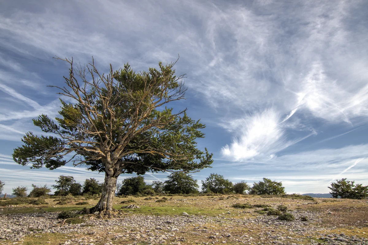
A solitary spreading tree stands in open grassland scattered with pale limestone, with smaller trees along the horizon and sweeping clouds overhead.

A broad-crowned tree on the limestone-strewn uplands of Urbasa-Andía, photographed in July 2015. This is wider park scenery, rather than a view of the Morterutxo trail.

Parque natural Urbasa 1.jpg — Mikipons / Wikimedia Commons / CC BY-SA 4.0 · Creative Commons

Walks and routes

Morterutxo: the short first visit

SL-NA 290 is a 0.89 km circular trail from Morterutxo parking. The operator gives 18 m of elevation change and 15 minutes without stops. Follow the interpretation through a compact mix of woodland and pastoral features.

Officially adapted for reduced mobility and vision, with Braille and easy-read panels. Ask about the current surface and whether assistance suits your equipment.


Morterutxo: the short first visit

Zelaiaundi and the Hayedo encantado

SL-NA 291 is the longer 7.9 km circuit from the Urbasa visitor centre, climbing through beech woods towards the northern crest. It includes a spur into the Hayedo encantado and has 437 m of elevation change.

Uneven tracks and paths, potentially muddy or slippery, with a substantial climb. Choose it for walkers comfortable with mountain terrain, not as an extension of the adapted trail.

Zelaiaundi and the Hayedo encantado

Ubaba: a cliff-landscape walk

From Ubaba parking, the signed out-and-back covers 4.4 km with 80 m of elevation change. It crosses pasture and limestone above the Améscoa valley. Cliff-bird interpretation and an observation telescope are listed along the route.

Low overall climbing does not remove the uneven rocky surface or fall risk near cliffs. Keep children close and well away from edges. It is not presented as an adapted route.

Ubaba: a cliff-landscape walk

Mirueta: the pastoral side of Andía

SL-NA 294 starts at Arbeltz parking and makes a 6.6 km circuit with 260 m of elevation change. Domed shepherds’ huts, enclosures and archaeological remains add context to the broad grazing landscape.

Irregular tracks and paths cross open pasture, where the line can be hard to pick out. This is a walking route rather than an adapted trail.

Mirueta: the pastoral side of Andía

Urederra: a separately booked river walk

Start at the Baquedano reception-area car park. The permitted visit is about 6 km in total with 100 m of elevation change, using signed outward and return sections through the river woodland. Keep to the path and provided viewpoints.

The reserve operator states that the route is unsuitable for reduced mobility and pushchairs. There are irregular and slippery sections; adapted toilets at reception do not make the walking route accessible.

Urederra: a separately booked river walk

A relaxed first morning

Check conditions before setting off. If the visitor centre is open, begin there, then use the signed Morterutxo parking and walk the short circuit. Leave time for panel stops and a picnic. Allow 2–3 hours overall; plan transport between the centre and trailhead, and ask staff if you need a suitable walking connection.

A longer day on foot

Choose either Zelaiaundi for a forest-and-crest walk, Ubaba for the cliff landscape, or Mirueta for open Andía pasture. Read that route’s full sheet, check the weather and build the day around one main walk. Do not add the three distances together as a connected itinerary.

A day centred on Urederra

Secure the reservation first and travel to Baquedano at the booked time. Walk only the authorised route, return to reception and keep any additional outing optional. This is a separate river visit within the same natural park.

Things to try

Make a small landscape notebook

Choose one rock, one tree and one sign of pastoral work that you can see from the permitted path. Sketch or photograph them, then use the interpretation to explain how they are connected. Leave natural objects in place.

Look for human history in the landscape

Notice huts, enclosures and charcoal-making heritage where the official routes interpret them. Read before guessing what a structure was used for; never climb ruins or rearrange stones.

Observe birds without approaching cliffs

Use binoculars from a safe place on the route. At Ubaba, the bird panel can help you understand the cliff habitat. Keep well back from the edge and avoid disturbing birds.

Arrange specialist activities separately

Caving, organised events and professional photography or filming need the appropriate permission. Ask the park before organising them. The ordinary walking visit does not include those activities, and drone flight is prohibited.

Shorten or postpone rather than push on

If the visitor centre is open and the road journey is safe, make the exhibitions the main event. Check the forecast again before any outdoor walk. Strong wind, dense fog or icy ground are reasons to postpone; neither woodland nor a river gorge is a reliable severe-weather refuge.

Wildlife and habitats

European beech — Fagus sylvatica

Begin with the tree that shapes so much of Urbasa. Look up into the canopy, then compare an open-grown tree with trees growing closely together. Use the route interpretation to help identify what you see.

Field maple — Acer campestre

The forest records also identify field maple. A useful challenge is to notice where the woodland changes, rather than treating every tree as a beech. Check a label or identification guide before naming an unfamiliar tree.

Black woodpecker — Dryocopus martius

A bird associated with the park’s mature woodland. Try a quiet listening pause on the path. If a bird calls, enjoy it from where you are rather than following it into the trees or playing a recording.

Rosalia longicorn — Rosalia alpina

This woodland beetle is one reason old trees and decaying wood matter. Look without lifting bark or moving logs. The habitat is worth noticing even when the insect itself remains out of sight.

Stories and discoveries

Much of the water travels out of sight

Limestone lets water move underground through cracks and cavities. Urbasa and Andía have separate aquifers divided by the Zunbeltz fault; their springs connect the upland landscape with the surrounding valleys.

The open grasslands have a human history

Grazing and woodland use helped shape the balance between forest and open ground. A raso is part of a lived-in pastoral landscape, rather than an empty space waiting for trees.

Ancient remains belong where they are

The park’s archaeological record includes flint-working remains and later prehistoric burial monuments. Their setting is part of their meaning: look, photograph and leave them untouched.

When to visit

Spring

Enjoy fresh woodland growth on a settled day, but pack for cold or wet conditions. Check current centre opening rather than assuming last Easter’s guided walks will be repeated.

Summer

Start exposed walks before the hottest part of the day, carry enough water and plan shaded breaks where available. Andía’s open pastures and the Ubaba route offer little cover.

Autumn

Choose a calm day for changing woodland colour. Wet leaves and limestone call for careful footing; shorter daylight makes an early start sensible. Download everything before reaching the plateau.

Winter

Snow, ice, fog and short daylight can make the same route much more demanding. Check roads and mountain conditions before leaving. If conditions are poor, save the plateau walk for another day.

Getting there and practical advice

Urbasa visitor centre

The Centro de acogida de visitantes stands on the northern NA-718 approach, around km 32. Exhibitions cover natural and cultural heritage; entry is free. The autumn schedule checked on 16 October 2026 lists Saturdays, Sundays and holidays from 3 October to 2 November, 10:15–17:00. Confirm your date on the official page.

Toilets, water and a picnic stop

The visitor centre lists exterior toilets with adapted access, a fountain and tables. Ask which facilities are available when the building is closed. Morterutxo has a small table area but no drinking-water source on the circuit, so arrive supplied.

Information in other sectors

Lizarraga’s hut is staffed occasionally, so bring your route information rather than relying on it being open. The Améscoas information point is at Ubaba parking and has a seasonal schedule. Check the relevant sector page before travelling.

Urederra reception and parking

Baquedano reception provides the designated car park, information and adapted-access toilets. Reserve entry in advance even if arriving without a car, arranging the vehicle-free booking with the operator. Car parking is listed at €5 on both the park page and booking introduction checked on 16 October 2026; check the amount and entry conditions when booking.

Contact before you travel

For trail condition, accessibility and visitor-centre questions: +34 848 424 690 or [email protected]. For the Urederra reservation portal: +34 948 539 426. Save replies and route information before entering areas without signal.

Urbasa and the short-trail visit

Use the NA-718 between Olazti/Olazagutía and Estella-Lizarra, then follow the signed access to the appropriate parking area. Keep the centre and Morterutxo as distinct destinations. Park only where authorised and leave road access clear for livestock and emergency vehicles.

Andía and Urederra need different approaches

Andía uses the NA-120 and cannot be reached by driving straight across Urbasa’s internal tracks. For Urederra, leave the NA-718 at Baríndano for the NA-7187 to Baquedano. The reserve visit begins at reception, not at a plateau viewpoint.

If you are not driving

Arrange and confirm the final journey to your chosen trailhead and the return before travelling. Do not assume there is a park shuttle or a convenient service between the separate sectors.

Plan around the actual adapted trail

Ask staff whether Morterutxo’s present surface, slopes and any temporary works suit your wheelchair, walking aid or pushchair. Explain the assistance your group needs. Download the easy-read information from the route page in advance if useful.

Separate building access from trail access

The centre’s adapted exterior toilets and porch are useful facilities, but its exhibition has two floors: confirm your access requirements before relying on the whole building. At Baquedano, accessible toilets do not alter the barriers on the Urederra path.

Choose the longer walks by terrain

Zelaiaundi has a significant climb; Mirueta has uneven pasture paths; Ubaba includes rocky ground and cliff hazards. None is described here as an adapted substitute for Morterutxo. Ask for a current route recommendation if the short trail cannot meet your needs.

Sources and useful links

Wildlife you might spot

4

Each card links to a full Explore page with photos, traits, and fun facts.

Snap map for this place

Start with the big picture, then zoom in to explore individual wildlife observations around this place.

Loading map…

Good to know before you go

Check the official notices before travelling. The notice checked on 16 October 2026 confirms Morterutxo and Zelaiaundi have reopened after filming, but recovery work continues: follow signs and staff instructions.

Download the official route information before leaving. Morterutxo’s page warns of no mobile coverage, and signal is patchy elsewhere in the park.

Bring drinking water, food, a warm layer and shoes with grip. Morterutxo has no water source on the route.

Use marked parking areas and authorised roads. Do not follow a navigation app onto forestry or livestock tracks closed to general traffic.

Keep children close beside cliffs and karst holes. Stay on the signed route, especially in fog; the shortest line across a pasture may be unsafe.

Keep dogs on a lead and give livestock room. At Urederra the lead must be no longer than 1 metre. Do not feed, touch or walk between animals and their young.

For Urederra, reserve in advance, park at the Baquedano reception area and carry the booking. The river’s actual source and final path section are closed; swimming is prohibited.

Take your litter home and leave flowers, fossils and dead wood undisturbed. Bring a cold picnic; drones are prohibited and caves are not casual walk-in attractions.

Frequently asked questions

Ordinary individual visits on foot do not need a park permit, and park entry is free. Urederra is the important exception: entry is free but advance reservation is compulsory, and using the Baquedano car park carries a charge. Organised activities have separate authorisation requirements.
The official homepage checked on 16 October 2026 explicitly says Morterutxo, Zelaiaundi and the affected parking areas have reopened. It also says recovery work is continuing. Check the notice again and obey any local diversions or temporary restrictions.
No. The only permitted visitor route into the reserve begins at Baquedano with a reservation. Do not use an old downloaded track to descend from Ubaba or enter a restricted section.
Start by discussing Morterutxo with the park staff, including the surface condition and your equipment. Its adapted design is specific to that route. The Urederra operator says its walk is unsuitable for reduced mobility and pushchairs.
There is no public through-driving connection between these sectors. Urbasa is approached on the NA-718; Andía uses the NA-120. Plan the road journey around the park rather than attempting to cross on tracks.
Do not count on a daily programme. The guided-visit page advertises specific Easter 2026 walks, which have already passed. Ask the visitor centre about future dates before planning around a guided activity.
Make the habitats and small discoveries the purpose of the visit. The park supports woodland birds and insects as well as larger animals, but wildlife sightings are never guaranteed. Grazing horses, sheep and cattle are domestic livestock.

Recent snaps at this place

Recent snaps will appear here as new observations are added.

View all ›

Take the discovery with you

Exploring Urbasa-Andía Natural Park?

Identify the wildlife you spot, learn as you go, and keep a collection of the adventure.

  1. 1Spot it
  2. 2Snap it
  3. 3Keep the discovery




