
Snappit logo
Snappit
Get App
Generic illustration, not a photograph of this venueIllustration
ParkCantabria, Spain

Saja-Besaya Natural Park

Saja-Besaya is a place to slow your walking down.

About

Saja-Besaya is a place to slow your walking down. Water, broadleaved woods and open grazing land give these Cantabrian valleys their rhythm. You do not need to cross the whole park to get a feel for it: a well-chosen patch of woodland is a much better first visit than a long list of distant viewpoints.

Begin at the interpretation centre just south of Saja village, on the CA-280 towards Palombera. The former forest house introduces the park’s natural life alongside the people who have worked in its woods and pastures. Use it to choose a walk that suits the weather and your group, rather than treating the displays as a quick stop before the “real” visit.

Our walking choice is Canto Pilanco, the signed CA-ENP10 circuit in this part of the park. It begins beside the Saja and climbs into beech woodland. The change from the river’s light and sound to the enclosed forest is the main reward. There is an optional, sharply climbing branch to a natural viewpoint; leave it out if the footing, weather or anyone’s confidence makes it a poor choice.

This is one small visit within a much larger protected area. The park spreads across the Saja and Besaya valleys and higher country; the centre also serves the wider Saja-Nansa area. Ucieda and Bárcena Mayor are separate approaches, not extra stops to squeeze into the same short woodland walk. Turn your visit into a safari! Use the Snappit app to scan and log wildlife sightings here.

The natural park was created in 1988 to conserve this part of Cantabria’s landscape and living systems. Its woods are not a scene untouched by people: grazing, timber work and charcoal making have helped shape what visitors see. On Canto Pilanco, pollarded beeches offer a tangible clue. Their branches were cut back repeatedly to provide wood. Saja village’s history is closely tied to woodworking and livestock. The Palombera road helped local people exchange wooden goods with communities on the other side of the mountains. The interpretation centre, opened in 2008 in the former forest house, brings those human connections into the nature story.

What to do here

Allow time in the centre, check the day’s route advice, then walk Canto Pilanco at a pace that leaves room to listen and look. Follow the signed circuit and decide separately whether to take the viewpoint branch. If a full forest walk does not suit the group, ask staff for a shorter option that is suitable that day.

Seasonal info

Wet leaves, mud and short winter days can turn a modest woodland walk into a slower outing. Snow, ice or strong winds are reasons to choose a different day. Autumn and winter also require a hunting-calendar check for the exact route, even when a trail appears on an official website.

Accessibility

Canto Pilanco uses riverside paths and climbing forestry paths, with a particularly steep optional viewpoint approach. Do not choose it as a wheelchair or pushchair route on the strength of its short distance. Ask the centre about step-free entry, exhibition circulation and toilet access. Río Bayones at Ucieda is a separate, partly adapted sensory walk; its features and limitations are described below.

Don't miss

1

An introduction to forest life in Saja’s former forest house

2

The changing woodland along the river and Canto Pilanco circuit

3

Old pollarded beeches that reveal the woodland’s working past

4

A separate sensory-walk option at Río Bayones, near Ucieda

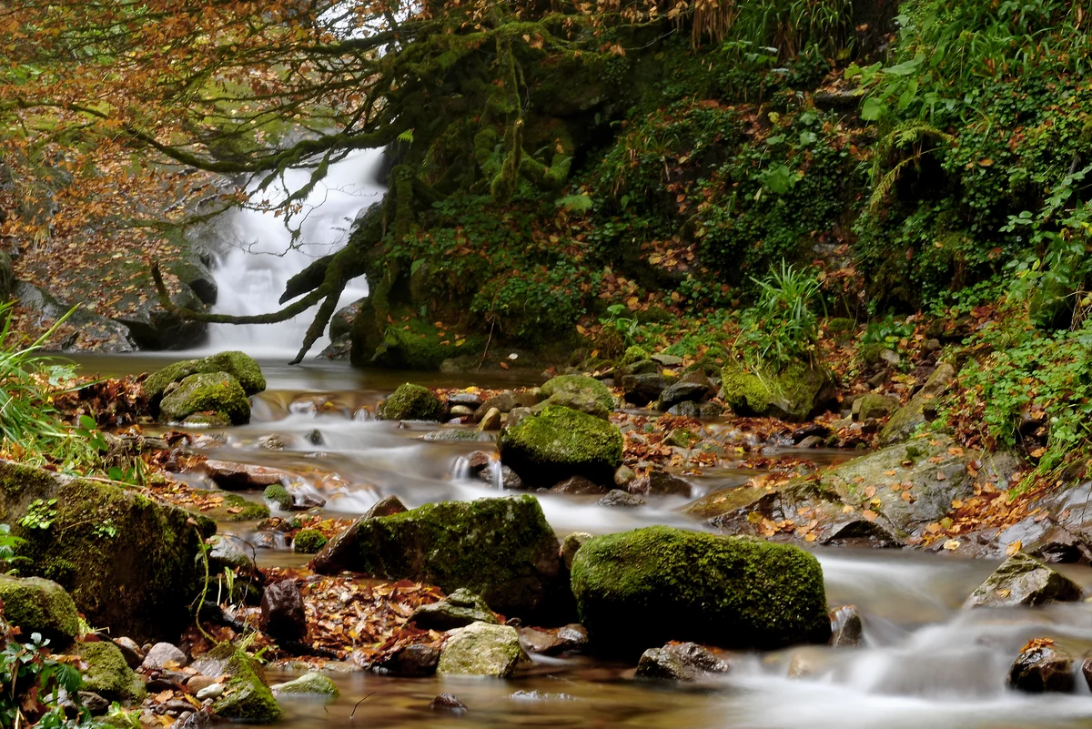
A stream flows over moss-covered boulders through autumn woodland, with fallen brown leaves along its banks.

An autumn stream in Saja-Besaya Natural Park near Bárcena Mayor, photographed in November 2012.

Saja-Besaya, otoño 4.jpg — LBM1948 / Wikimedia Commons / CC BY-SA 4.0 · Creative Commons

Walks and routes

Canto Pilanco: river, beechwood and an optional viewpoint

Follow CA-ENP10 from the Bárcena Sellano bridge area. The opening riverside section joins La Cotera track before old forestry paths climb into the beechwood. The published circuit is 4.8 km. Partway round, the viewpoint is reached by a short but demanding out-and-back branch; rejoin the main circuit afterwards. The return uses woodland paths and La Cotera track. Ask for the current route information at the centre and follow the signs rather than a different trail with a similar name.

Climbing forest paths, uneven or wet ground and the steep viewpoint branch need confident footing. Ask staff to help select a different outing if these features do not suit your group; do not assume this is a step-free circuit.


Canto Pilanco: river, beechwood and an optional viewpoint

Río Bayones: a separate sensory-walk option at Ucieda

For another day or a different access choice, head to Casa del Monte near Ucieda. The local authority describes a 2 km circular walk with a partly railed first kilometre and tactile panels with raised illustrations and Braille. The return kilometre follows a forest track where vehicles may pass. Its published walking time is 30–40 minutes, but the panels are a reason to take longer.

The adaptation is specifically for visitors with visual impairment and does not certify the whole loop for wheelchairs. Confirm the condition of the guiding rail and panels, the surface and gradients, and whether assistance is needed. Take particular care on the shared vehicle track.

Río Bayones: a separate sensory-walk option at Ucieda

A half day with one woodland walk

Start with the centre and the practical questions: weather, hunting, path condition and your group’s needs. Walk Canto Pilanco if the answers fit, take a food-and-water break at a suitable permitted spot, and leave the viewpoint branch optional. Return with enough daylight and time for your transport.

A gentler change of plan

If the circuit is too much or conditions deteriorate, make the centre the main visit and ask staff what short outdoor option is suitable. Choose Río Bayones only if you have separately confirmed its access and can travel to Ucieda; do not improvise a drive across the park to rescue a wet afternoon.

Things to try

Make a two-place sound map

At safe stopping places, spend a minute listening beside the river and another under the trees. Children can sketch the sounds with simple marks, then compare the two pages. Keep the path clear and stay away from the water’s edge.

Read a tree’s working history

Ask staff to explain what pollarding means, then look for the old shapes mentioned in the route description. Sketch a tree from the path instead of touching cavities or climbing into it.

Join an interpreted walk

Check Naturea’s live programme if you would rather walk with someone who can explain the habitats. Choose an activity whose length and terrain suit everyone, book the places you need, and confirm the actual meeting point.

Keep the woodland story indoors

If the centre is open, spend more time with its displays and audiovisual material and ask about forest management and local life. Confirm opening before travelling. Strong wind or heavy rain is a reason to postpone the outdoor circuit, not to rely on the trees as shelter.

Wildlife and habitats

European beech

The canopy is part of the experience. Compare the light beneath the beeches with the more open riverbank, and look for old pollarded forms without leaving the path.

Bilberry

Look closely at the low woodland vegetation with a guide or field book. Naturea records bilberry along this route; enjoy finding the plant and leave its berries for wildlife.

Black woodpecker

Make a quiet listening stop in the beechwood. Naturea includes this forest bird in its route account. Use a field guide to check a call or distant view; do not play recordings or search for a nest.

Short-toed treecreeper

Pause beside the trail and scan the trunks as well as the canopy. This small woodland bird is named in the route account. Patient observation is more useful than chasing a movement through the trees.

Stories and discoveries

A landscape shaped by work

Open grazing land and woodland are connected parts of the park’s story. The protected landscape supports a history of rural livelihoods as well as habitats, which is why the centre gives both subjects space.

One centre, a wider territory

The name on the centre’s page includes both Saja-Besaya and Saja-Nansa. Its advice and activities extend beyond this single natural park, so always check which area a booked outing actually visits.

When to visit

Spring and summer

Look for contrasts between the river corridor and the leaf canopy. Choose dry, calm conditions where possible, carry enough water and keep a waterproof even when the morning starts bright.

Autumn and winter

Enjoy the changing woodland, but give priority to daylight, footing and the hunting schedule. If there is ice, strong wind or heavy rain, move the walk to another day. Ask about a seasonal guided activity rather than approaching wildlife independently.

Getting there and practical advice

Saja interpretation centre

Find the former forest house on the CA-280 at kilometre 13, just south of Saja village in Los Tojos. Exhibitions and audiovisual material introduce the protected landscape. Entry is listed as free; call +34 608 065 846 before a special trip, particularly during school terms.

Opening, bookings and practical needs

Hours vary with the season. The published October schedule is Wednesday–Friday 10:00–17:00 and weekends and public holidays 10:00–19:00. Staff can be out with a group, so check the date directly. Naturea’s central information and booking number is +34 942 049 438, Monday–Friday 09:00–14:00. Ask about toilets, drinking water and the access features your group needs.

By road to the Saja gateway

Use the centre’s CA-280 kilometre-13 address, rather than a general park pin. If you approach from the north, there is no need to continue over Palombera after reaching the centre. Check where you may park and how to reach the circuit safely before leaving the vehicle.

By public transport

The Cantabria transport portal lists K4904 with Saja–Cabezón de la Sal itineraries. Confirm current operating days, departure times and your return with the operator, then arrange the village-to-centre leg. Do not assume a bus stops at the centre or that there is a continuous safe pedestrian route beside the road.

Ask about the centre itself

Explain the assistance you need when you call: step-free arrival, doorway access, exhibition circulation, seating and toilets. Naturea’s programme-wide accessibility page is not a detailed access audit for this building.

Match the walk to the person

A route adapted for sight loss and a step-free route address different needs. Discuss Río Bayones’ guiding features and shared track with staff; for Canto Pilanco, ask about the climbing ground and possible alternatives rather than assuming the first riverside section is accessible.

Sources and useful links

Wildlife you might spot

4

Each card links to a full Explore page with photos, traits, and fun facts.

Snap map for this place

Start with the big picture, then zoom in to explore individual wildlife observations around this place.

Loading map…

Good to know before you go

Check with Naturea for the exact route’s current condition and hunting activity before travelling, especially on autumn and winter weekends. Obey closures and on-site instructions.

Look at the AEMET forecast and warnings, then reassess at the trailhead. Skip the Canto Pilanco viewpoint branch in adverse weather.

Wear grippy walking footwear and carry water, a snack, a waterproof and a warm layer. Keep enough daylight for the return.

Confirm centre opening before making a special journey: staff may be out with school groups. For a guided walk, reserve in advance and use the meeting point in your confirmation.

Keep children beside you near water and on steep ground. Photograph the river from the path rather than stepping onto wet boulders.

Listen quietly, use binoculars and give wildlife space. Leave plants, fungi, fallen wood and berries where they are, and take all litter home.

Park only where permitted and leave forest access clear. Do not follow a vehicle navigation shortcut along a forest track.

Naturea’s guided activities do not accept pets. Ask separately about the rules for a self-guided visit or any assistance-dog arrangement before travelling.

Frequently asked questions

No. It is a useful gateway in Los Tojos. Saja-Besaya covers parts of six municipalities and the shared Campoo-Cabuérniga territory, with several different approaches. The wider Saja-Nansa area served by the centre is larger again.
The centre lists free entry. Guided Naturea activities require advance booking and may have a charge; check the chosen activity’s current price and conditions. Large groups and visitors during school terms should contact the centre before arriving.
It is a relatively short forest circuit, but it climbs and its viewpoint branch is steep. Choose it for children and adults who are comfortable on uneven paths. A smaller distance does not automatically make a route suitable for pushchairs or people with reduced mobility.
No. Naturea describes it as an out-and-back branch from the circuit. The forest is worth visiting without it. Ask staff to explain the junction and keep to the main signed route if you leave the branch out.
The regional transport portal lists a K4904 connection between Saja village and Cabezón de la Sal, but confirm operating days and both journeys before relying on it. The village stop is not a confirmed stop at the centre. Arrange the last leg and return pickup rather than assuming the roadside approach is a safe walk.
Plan the day around the habitat rather than a sighting. Birds may be easier to hear than see, and the changing trees and river are rewarding in their own right. For seasonal wildlife activities, ask Naturea what is currently offered and follow the guide’s approach.

Recent snaps at this place

Recent snaps will appear here as new observations are added.

View all ›

Take the discovery with you

Exploring Saja-Besaya Natural Park?

Identify the wildlife you spot, learn as you go, and keep a collection of the adventure.

  1. 1Spot it
  2. 2Snap it
  3. 3Keep the discovery




