Snappit logo
Snappit
Get App
Generic illustration, not a photograph of this venueIllustration
ParkKR

Dadohaehaesang National Park

Dadohaehaesang rewards a small, well-chosen plan.

About

Dadohaehaesang rewards a small, well-chosen plan. Its protected land and sea are scattered across several island groups, so there is no single entrance and no sensible one-day circuit of the whole park. A forest path beside the pebbles at Gugyedeung feels very different from Palyeongsan’s rocky peaks, Hongdo’s sea cliffs or the lighthouse country of Geomundo. Start with the experience you want, then choose accommodation and transport around it. Island villages, working harbours and protected habitats sit close together; a national-park label does not make every field, shore or island freely accessible. Be ready to snap and learn! Get the Snappit app to identify any nature species you find here.

Designated on 23 December 1981, Dadohaehaesang protects a maritime landscape as well as land. Its eight management districts range from Heuksan–Hongdo in the west to Geomun–Baekdo and the Yeosu coast in the east, with Palyeongsan adding a mainland mountain landscape. KNPS describes a mixture of ancient metamorphic rocks, sedimentary formations and volcanic rocks across the park and its surroundings. The cliffs do not all have the same geological origin. Villages and sea routes are part of the visitor experience, while habitat protection explains why some attractive-looking places remain off limits.

What to do here

For a first visit, choose Gugyedeung if you want a gentle coastal outing, Palyeongsan for a serious mountain day, or one island base for walking and sea views. Cheongsando and Bogildo suit a Wando-based trip; Jodo and Gwanmaedo belong to a Jindo approach; Hongdo and Heuksando are usually planned from Mokpo. Geomundo is a separate eastern-island journey. Do not combine these gateways merely because they share a park name.

Seasonal info

Summer brings heat, humidity and periods of heavy rain; exposed rock and coastal decks need particular care when wet. Winter daylight is shorter and strong winds can disrupt sea travel. Autumn hiking may also require a trail reservation. Check the specific route shortly before travel, even if the general park page looks reassuring.

Accessibility

Gugyedeung is the most promising first enquiry for visitors needing a gentler route: KNPS describes a nearly level nature trail with an accessible observation path. Its loose-pebble shore, steps and rocky coastal extension are separate obstacles. Ask about the exact accessible section, toilets and parking before travelling. Island ferries, gangways, local vehicles and accommodation each need their own access check.

Don't miss

1

Gugyedeung’s wave-rounded pebbles and protective coastal woodland

2

Palyeongsan’s succession of rocky peaks above the island-dotted sea

3

Distinct island walks on Cheongsando, Bogildo, Jodo and Geomundo

4

Hongdo’s coastal scenery and Heuksando’s forest and migration landscapes

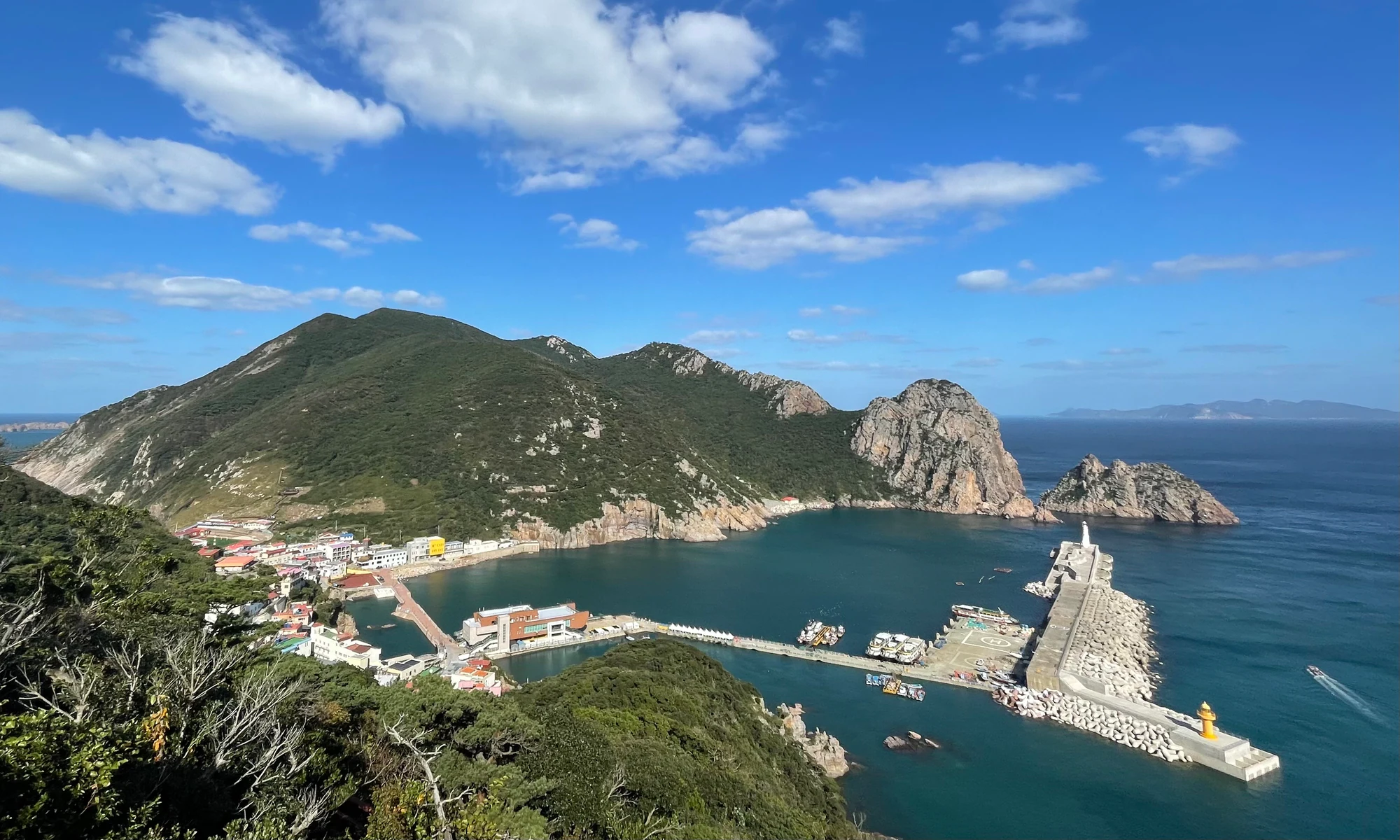
Blue water surrounds a Hongdo harbour with breakwaters, village buildings and a wooded rocky ridge behind it.

A historical view of Hongdo’s village, harbour and wooded cliffs in October 2023. The village and harbour are shown as island context.

“Hongdo Coastal Port 2023-10 Korea” by Gupdaal, CC BY 2.0. · Creative Commons 1 · Creative Commons 2

Walks and routes

Wando: Gugyedeung shore and woodland

Walk beside a pebble shore backed by a windbreak forest planted to protect the village landscape. KNPS describes a 2.4 km return nature-observation course taking about an hour; give yourself 1–2 hours to pause and listen to stones moving with the waves. Stay on the woodland path if you want the gentler experience. Gugyedeung route.

The nature trail is described as nearly level and includes an accessible observation section. Loose stones, shore steps and the rock/deck extension are not equivalent to that accessible section.


Wando: Gugyedeung shore and woodland

Goheung: Palyeongsan campsite loop

A demanding choice for confident hikers who want successive rock peaks and wide coastal views. The reservation itinerary goes from the campsite past Heundeulbawi and Yuyeongbong, through Jeokchwibong and Tapjae, then returns to the campsite: 6 km, officially about 3 hours 40 minutes. Allow 5–6 hours on foot with rests if this suits your fitness, plus travel. The separate 6.7 km Nampo Art Museum route finishes elsewhere. Loop and reservation details.

Steep rocky terrain makes this unsuitable for wheelchairs, pushchairs or a casual family stroll. Wet rock, exposure and fatigue can make the return much harder.

Goheung: Palyeongsan campsite loop

Cheongsando: a short hike from Gwondeok

Choose the Gwondeok–Beombawi segment for a compact walk to a rocky sea-view landmark. KNPS gives 1.0 km and approximately 25 minutes for the named segment. This is not the whole outing from the ferry terminal: allow time for the return, pauses and transport across the island. The separate Sangseo–Maebongsan course is listed at 2.2 km and 40 minutes if you want another starting point. Gwondeok course.

A mountain path, not a verified step-free viewpoint. Check footing carefully in humid woodland and carry enough water before leaving the village.

Cheongsando: a short hike from Gwondeok

Bogildo: Bo-ok-ri to Yesong-ri

This is a substantial cross-island hike through the Gyeokjabong landscape, starting near Bo-ok-ri’s rounded-stone shore and finishing at Yesong-ri. The official sources agree on 6.0 km one way; their walking estimates range from 2 hours 50 minutes to 3 hours 20 minutes. Plan a longer hiking day with rests and arrange transport from the far end before setting off. Bo-ok course.

Uneven mountain terrain and damp surfaces; not a step-free route. The coastal approach does not indicate an easy walk all the way across the island.

Bogildo: Bo-ok-ri to Yesong-ri

Jodo: Dondaebong between villages

The named walk runs from Sanhaeng village past Finger Rock and Dondaebong to Eupgu village. KNPS lists 2.3 km and around 1 hour 20 minutes. It is a manageable-length hill walk for prepared walkers, with the island groups spreading out below. Because the ends differ, settle your local transfer before hiking. Nearby lighthouse and viewpoint visits are separate additions, not included in this trail distance. Jodo course.

Short does not mean barrier-free: this is a hill trail. Allow extra time for uneven footing and avoid exposed viewpoints in strong winds.

Jodo: Dondaebong between villages

Gwanmaedo: village lanes or the Sky Bridge walk

For the gentler option, explore Gwanmae village’s level lanes and pine-grove paths at an unhurried pace. For a more active walk, KNPS describes a 1.63 km return from Gwanho village through Angdeokgimi toward the stone formations and Haneuldari, the Sky Bridge, taking about 1 hour 10 minutes. The route becomes steeper beyond Angdeokgimi, so turn around there if the group needs an easier outing. Gwanmaedo course.

The flatter village option is different from the steeper bridge route. No continuous step-free circuit is verified.

Gwanmaedo: village lanes or the Sky Bridge walk

Geomundo: Deokchon to the lighthouse

Choose this for a full coastal hiking day rather than a quick harbour stop. The trail links Deokchon with Bultanbong, coastal rock scenery and Geomundo Lighthouse. KNPS publishes 5.9 km one way; the web guide estimates 2 hours 30 minutes and its map 2 hours 40 minutes. Add a generous allowance for rests and the journey back. Shorter official options start at Geomun-ri or Seodo Elementary School. Deokchon course.

A mountain-and-coast route with climbing and uneven ground. It is not a level lighthouse promenade; a sea-facing section may be unsuitable in rough weather.

Geomundo: Deokchon to the lighthouse

An easy first half-day from Wando

Make Gugyedeung the main stop. Walk the woodland section, pause at a permitted shore viewpoint and return while everyone still has energy. Add a meal in Wando rather than rushing onto a ferry for a second park district. This is the simplest plan for a mixed-ability group, after checking the exact access arrangements.

Two or three days on one island group

Travel to your chosen mainland port the day before an early sailing when practical. Use the first island afternoon for orientation, keep the best-weather day for one walk or boat trip, and return with spare time before onward commitments. Check the next day’s operation with the ferry company each evening. Accommodation and a flexible return matter more than adding another island.

Things to try

Hongdo and Heuksando: choose an island focus

Hongdo is the choice for dramatic coastal rock scenery; a sightseeing boat, when operating, offers a different perspective from the village. Heuksando offers a larger island circuit with village, forest and cultural stops, which can be explored using locally arranged road transport. Reach these western islands through Mokpo’s coastal passenger terminal, confirming each leg. The current Hongdo rockfall closure means the older Gitdaebong walking description should not drive your booking. Choose permitted village areas and an operating boat trip, or choose another island. Hongdo information · Heuksando information.

Other parts of the park

Near Yeosu, Hyangiram combines a steep temple approach with coastal views; keep voices low around worshippers. Bigeum–Docho, Soando, Geumodo, Narodo and Geogeumdo offer further island or hill options in the official maps and course list. They work best as later trips chosen around a particular trail. Ui-do and Jangdo currently need special caution because of construction closures. For Narodo’s Bongnaesan, confirm access after the October 2026 launch-related restriction before planning a hike.

When the sea or trails say no

If a warning stops ferries or closes a route, keep the day on the mainland or stay near your island accommodation. A meal, rest and revised sailing plan are better than substituting an exposed coastal walk. Do not use sightseeing boats as a workaround for cancelled passenger services. After heavy rain, wait for the park’s reopening confirmation before returning to rocky trails.

Wildlife and habitats

Japanese black pine

Japanese black pine is documented in Heuksando’s mixed forest communities. From open public paths, notice how the needle-bearing crowns contrast with the broad-leaved evergreen canopy. This forest association comes from field research, not a promise that a particular tree will be beside your chosen trail. Heuksando forest study.

Barn swallow

Spring-migration research documented wild barn swallows on Heuksando. Watch for fast-moving birds over open areas, keeping well back from resting groups and roosts. Migration varies from day to day, so make birdwatching an enjoyable part of an island stay rather than a guaranteed sighting target.

Protecting the less visible wildlife

The park’s flagship wildlife includes a finless porpoise and the pungnan orchid. Neither is a reliable casual sighting. Do not seek out sensitive orchid locations, enter closed habitat or ask a boat to pursue marine mammals. Quiet observation and leaving plants untouched matter more than completing a species checklist.

Getting there and practical advice

Camping and practical bases

KNPS lists bookable campsites at Gugyedeung and Palyeongsan, with toilets, showers and washing facilities. Reserve a specific site and check its equipment and seasonal rules; do not assume that a house-type unit includes bedding or cooking gear. For island stays, confirm meals, drinking-water supplies and local transfers with your accommodation before arrival. Gugyedeung campsite · Palyeongsan campsite.

Match the port to the trip

Use Wando’s passenger terminal for Cheongsando, and check the separate Hwaheungpo route for a Bogildo journey. Jindo Port is the approach to Jodo and Gwanmaedo; Mokpo serves the Hongdo/Heuksando trip. For Geomundo, KNPS directs visitors to check Yeosu or Nokdong. These are planning gateways, not a single connecting ferry network. Compare the KSA ferry booking service with the operator’s current notice; Wando also provides Cheongsando ferry information.

Ask about the complete journey

For an island trip, ask the ferry company about the gangway, steps, onboard toilets and assistance for the particular sailing. Then confirm the vehicle from the port, the entrance to your accommodation and your walking destination. A short advertised trail length does not establish wheelchair access. For Gugyedeung, ask the park office to identify the accessible observation section rather than attempting the loose-pebble beach.

Sources and useful links

Wildlife you might spot

2

Each card links to a full Explore page with photos, traits, and fun facts.

Snap map for this place

Start with the big picture, then zoom in to explore individual wildlife observations around this place.

Loading map…

Good to know before you go

Choose the island or trailhead before booking transport. “Dadohaehaesang National Park” alone is too broad a destination for navigation.

Book the outward and return ferry legs together where possible, and confirm the actual boarding terminal. Carry the identification required by your operator.

Leave an extra night’s essentials and schedule flexibility for island travel. Avoid placing a weather-dependent ferry immediately before an important flight or appointment.

Carry drinking water, food, sun protection, a waterproof layer and footwear suitable for the chosen terrain. Small islands have limited transport and medical services.

Keep to public paths and signed open trails. Leave pebbles, shells and plants where they are, and give feeding or resting wildlife space.

On 18 October 2026, the western park control page still listed a rockfall closure on Hongdo and works on Ui-do and Jangdo. Read the [current western controls](https://www.knps.or.kr/front/portal/safe/acsCtrDtl.do?menuNo=8000340&rstId=0016) before planning those walks.

Frequently asked questions

Yes. Gugyedeung on road-connected Wando and Palyeongsan in Goheung are useful choices. The Dolsan/Hyangiram area is another road-accessible option near Yeosu. These visits give you a genuine part of the park without committing to an outer-island crossing.
Do not plan on it without fresh confirmation. The western control notice checked on 18 October 2026 closes Hongdo 1-gu to Misebat junction for rockfall until a separate lifting notice. A general page describing the mountain route is not proof that it has reopened.
No. KNPS identifies Gugyedeung as a no-swimming area. Enjoy the shore from the permitted paths; the attractive pebbles and clear water do not make it a bathing beach.
There is no single booking that covers an entire Dadohaehaesang trip. Trail reservations, campsites, ferries, sightseeing boats and accommodation are separate arrangements. Confirm the rules and availability for each part you actually intend to use.

Recent snaps at this place

Recent snaps will appear here as new observations are added.

View all ›

Take the discovery with you

Exploring Dadohaehaesang National Park?

Identify the wildlife you spot, learn as you go, and keep a collection of the adventure.

  1. 1Spot it
  2. 2Snap it
  3. 3Keep the discovery