Snappit logo
Snappit
Get App
Generic illustration, not a photograph of this venueIllustration
ParkKansai / Tokai, Japan

Ise-Shima National Park

Ise-Shima is a national park of wooded hills, intricate coastlines and places where people still work with the sea.

About

Ise-Shima is a national park of wooded hills, intricate coastlines and places where people still work with the sea. For an unhurried first taste, concentrate on Yokoyama Visitor Center and the viewpoints above Ago Bay in Shima City. This makes a satisfying small outing on its own: an introduction indoors, a climb or short ramp approach, and time to make sense of the islands below. Ise Jingu, Toba’s islands and the outer-coast beaches belong to the wider park, but each needs a separate journey.

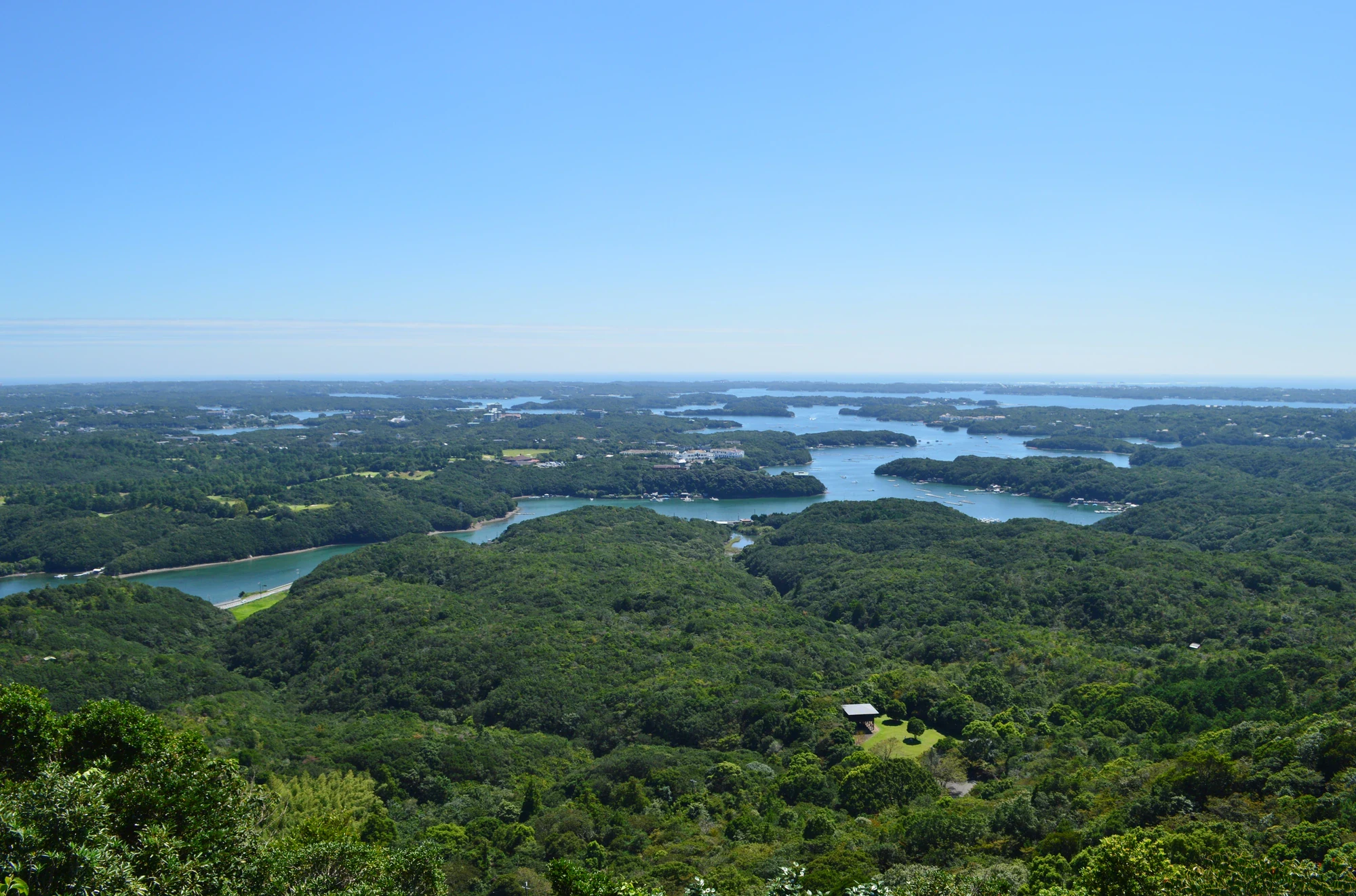
The main reward is Yokoyama Tenkū Café Terrace, a broad wooden lookout about 140 metres above sea level. Forested fingers of land overlap across the water, small islands interrupt the blue, and pearl-farming rafts reveal that this is a working bay. Look beyond Cape Goza for the Pacific horizon when visibility allows. Before taking a photograph, try following one strip of water inland: the irregular outline is the clue to a ria coast, formed when the sea flooded former valleys.

Komorebi Terrace gives the same outing a quieter, more enclosed feel, with trees around the viewing space. If your group still wants to walk, the paths climb onward to Soyokaze Terrace, Miharashi View Point and Ago Bay View Point. Miharashi adds inland mountains to the outlook; Ago Bay View Point brings the near side of the bay into stronger focus. None is a compulsory summit. Choosing one additional viewpoint leaves more time for watching the forest and avoids turning a family stop into a hurried circuit.

The trees are part of the story too. Much of Yokoyama’s woodland is evergreen broadleaf forest, encouraged by the mild maritime climate. Ubame-gashi oak has supplied dense wood for hard binchōtan charcoal, while other oaks were used as fuel. This is satoyama: woodland shaped by generations of human use. Across the water, satoumi describes coastal environments managed alongside fishing and aquaculture. The view joins these two worlds, rather than showing a landscape entirely separate from everyday life.

The visitor center makes those connections easy to explore. Its displays and immersive theater, with images on three walls and the floor, introduce the landforms, wildlife and livelihoods of Ise-Shima, including pearl cultivation, ama divers and charcoal making. Down in Sozo-no-Mori, ponds, a research biotope and planted flower areas reward slower looking. A short spell watching the water’s edge can be a good change of pace after the panorama, particularly for children who enjoy noticing small things. Wondering what that bird or insect is? Find out on your visit using the Snappit nature app.

Ise-Shima National Park was designated on 20 November 1946. Its character includes the long relationship between communities, shrine forests, cultivated woodland and coastal resources. At Yokoyama, the links are particularly visible: charcoal-making trees above a bay used for pearl and seaweed cultivation. The memorial near Miharashi View Point recalls pearl-cultivation pioneer Mikimoto Kōkichi. The visitor center also introduces ama traditions, but the divers’ working grounds and the Ise shrines are elsewhere in the wider park, not stops on this hillside walk.


What to do here

Start at Yokoyama Visitor Center for a map, the day’s access advice and a look at the theater and displays. Make Tenkū Café Terrace your main outdoor stop, then add nearby Komorebi Terrace if the route is open. Treat the higher viewpoints as an optional woodland walk, with a turnaround chosen for the slowest walker. Back at the lower area, look at Sozo-no-Mori’s ponds and seasonal gardens, or settle into the birdwatching shelter. A café drink, sketch of the coastline or quiet ten-minute bird watch can be more rewarding than rushing to every deck. Check the dated access notice before choosing your approach.

Seasonal info

March–April usually brings cherry blossom, with pink azaleas in April–May. Hydrangeas and lively insects add interest toward the rainy season and summer, when humid uphill walking calls for water and shorter stages. Autumn colour is a smaller accent in this largely evergreen forest and tends to arrive late, around November. Winter can give clearer views and easier birdwatching through leafless branches. For winter 2026–27, the scheduled access works change the approach substantially; check the access update.

Accessibility

Under normal arrangements, a ramp from upper parking P2 reaches Tenkū Café Terrace, and a wheelchair-accessible connection continues to Komorebi. The visitor center has a ramped entrance, and multipurpose toilets are listed at several main facilities. This does not make the uphill route from P1 or the higher-viewpoint network step-free. During the planned 24 November 2026–1 March 2027 works, the approach detour has about 400 steps and no wheelchair or stroller ramp. Contact the center before booking transport if you need step-free access; do not assume the usual P2 approach will be available.

Don't miss

1

The wide Ago Bay panorama from Tenkū Café Terrace, with islands, wooded peninsulas and pearl rafts

2

A quieter pause at tree-framed Komorebi Terrace, with higher viewpoints optional

3

The visitor center’s immersive introduction to the coast, forest and local livelihoods

4

Sozo-no-Mori’s ponds, seasonal flowers and winter birdwatching shelter

Blue water threads between green wooded headlands, with scattered buildings and a clear sky above.

Wooded headlands and sheltered inlets of Ago Bay, seen from Yokoyama Viewpoint on 15 September 2019.

Ago Bay viewed from Yokoyama Viewpoint.jpg — Saigen Jiro, CC0 1.0 (https://creativecommons.org/publicdomain/zero/1.0/). Source: https://commons.wikimedia.org/wiki/File:Ago_Bay_viewed_from_Yokoyama_Viewpoint.jpg. Resized and recompressed as WebP; no crop or retouching. · Creative Commons

Walks and routes

Short visit: Tenkū and Komorebi

When upper access is open, follow the ramp or steps from P2 to Tenkū, then continue to Komorebi and return. Make this the whole outdoor visit if a short outing suits your group. If starting below, add the uphill approach and descent; ask staff which path is open.

The wheelchair-accessible connection begins at P2 and serves Tenkū and Komorebi. Ask staff whether its slopes and surfaces suit your needs. The climb from lower parking is separate.

Short visit: Tenkū and Komorebi

Longer option: the published Yokoyama Walking Trail

The published course starts and finishes at the visitor center, visits the higher lookouts and drops toward Lawn Park before returning. Choose it for a walking-focused visit, with time to stop at viewpoints and recover from the climbs. Pick up the current map rather than following a remembered sequence of turns.

Expect steep, uneven sections and steps. If you need a step-free visit, choose the P2–Tenkū–Komorebi option instead and check whether upper access is open.

Longer option: the published Yokoyama Walking Trail

Lower-area pause: visitor center and Sozo-no-Mori

Spend time indoors, then choose a short look at the shelter, seasonal flower areas or ponds. This is a useful option when the full climb feels too much. Stay with the parts your group can comfortably reach and return without needing to make a loop.

The center has a ramp and multipurpose toilet. Ask staff which garden and pond paths suit your group’s mobility needs.

Lower-area pause: visitor center and Sozo-no-Mori

A relaxed first visit

About 1½–2½ hours on site; longer if parking, diversions or walking pace require it.

Begin with roughly half an hour in the visitor center and ask about the open approach.

Reach Tenkū by the suitable, currently permitted route. Pause for the bay and a drink or snack.

Add Komorebi if available, then return. Use any remaining energy for a small lower-area nature stop rather than another climb.

A longer woodland and viewpoint visit

Roughly 2½–3 hours under normal access, plus travel.

Check the route at the visitor center before choosing the published 3 km course.

Take the higher viewpoints slowly, comparing the bay outlook with the inland view from Miharashi.

Follow only the currently signed open route toward Lawn Park and back, and leave time for displays or pond watching at the end.

Things to try

Read the shape of Ago Bay

At Tenkū, choose one wooded peninsula and trace the water around it with your eyes. Then compare that shape with the landform exhibit downstairs. Ask which parts might once have been valley sides and which higher pieces now look like islands.

Find the working landscape

Look for the geometric patterns of pearl rafts among the organic shapes of islands and inlets. The visitor center explains how marine livelihoods fit into this coast; the terrace is for viewing them, not for approaching working rafts or entering private shore facilities.

Make a two-minute forest sound map

On a safe, wide part of the path, stop quietly and note sounds from above, below and across the slope. Repeat in the lower gardens. Birds, insects and the movement of people can make the same hill sound quite different through the seasons.

Watch a pond without collecting

From a safe path edge, notice where plants meet open water and wait for movement. The Sozo-no-Mori biotope is used for ecological research, including frog monitoring. Leave eggs, tadpoles and plants untouched; a drawing is a better souvenir.

Choose one higher lookout

If everyone is comfortable on the climb, pick Soyokaze, Miharashi or Ago Bay View Point as your extra destination. Compare the view with Tenkū, then turn back while the walk still feels enjoyable. Visiting every platform is optional.

Connect the forest to the sea indoors

Use the theater and displays to follow one resource, such as charcoal wood or a pearl oyster, from its habitat into local life. Ask at the desk about today’s programs; occasional crafts and experiences should not be assumed to run on demand.

Keep the visit indoors when appropriate

If travel conditions are safe and the center is open, spend time with the landform displays and theater instead of insisting on a panorama. Ask the desk about conditions before adding any outdoor section. Strong wind or storm warnings are a reason to postpone the hill, not simply carry a larger umbrella.

Wildlife and habitats

Japanese cheesewood

Woodland trail margins

Harlequin glorybower

Woodland trail margins

Long-tailed tit

Woodland and lower Sozo-no-Mori viewing areas

Grey heron

Sozo-no-Mori pond and wetland edges

Black kite

Sky visible from the bay-facing terraces

Osprey

Ago Bay as seen from the observation decks

Use these ideas for a slow look around Yokoyama. Plants and birds appear at their own pace, so treat the list as a set of possibilities rather than a checklist to complete. Keep to the paths and let wildlife carry on undisturbed.

Stories and discoveries

A coast made from drowned valleys

The narrow inlets and irregular islands are the visible result of former valleys being flooded by the sea. From above, the coast becomes easier to read than it does from a single waterfront stop.

Evergreen does not mean unchanging

Yokoyama’s forest stays largely green through winter, yet spring brings new leaves in contrasting colours and the shedding of older foliage. Look for changes in the canopy as well as flowers at eye level.

The ponds have a research role

Sozo-no-Mori’s biotope was created for ecological work and learning. Volunteers monitor frog eggs there, making this small wet place part of a longer record of the area’s nature.

Ama culture extends beyond the panorama

The center introduces the women divers who gather marine resources around the wider coast. The official bay interpretation places this activity outside Ago Bay’s mouth; a viewpoint visit is not an ama demonstration or a guaranteed view of divers at work.

When to visit

Spring: leaves as well as blossom

Look for cherry blossom in March–April and pink azaleas in April–May. Compare the new leaf colours of evergreen trees with the older canopy; exact flowering dates vary.

Summer: insects and shorter climbs

Hydrangeas in the managed lower garden, dragonflies and the sound of cicadas give a different focus from the long views. Carry water and take the uphill section slowly in humid weather.

Autumn: a mainly green woodland

Expect patches of late colour rather than an entirely red hillside. Around November, acorns and the changing canopy make good subjects for observation from the trail; leave them where they lie.

Winter: birds and clearer distance

Leafless branches make mixed small-bird groups easier to follow, and clear air can sharpen the bay view. Bring a layer for stops. The winter 2026–27 construction schedule is a major exception to normal arrival and step-free access.

Getting there and practical advice

Yokoyama Visitor Center

Entry is free, with daily opening from 09:00 to 16:30. Check for temporary changes before travelling. Exhibits, a four-surface theater, information desk and a small shop/rest area make it a useful start or a short indoor visit. Address: 875-24 Ugata, Ago-cho, Shima, Mie. Telephone: +81 (0)599-44-0567.

Tenkū Café Terrace and Mirador Shima

A takeout café and free rest area sit beside the principal viewpoint. Normal service is listed as 09:00–16:30, with bad-weather exceptions. Expect refreshments rather than treating the café as a guaranteed full lunch stop; check the current menu and opening.

Toilets

Multipurpose toilets are listed at the visitor center, P1, P2, the Tenkū rest facility and Lawn Park. Use a lower or parking-area toilet before climbing, especially at busy times. Access during works and facility opening hours may differ.

Sozo-no-Mori shelter and Lawn Park

The lower shelter offers a place to sit and watch the trees. Lawn Park is a separate grassy picnic area linked by hillside paths; reaching it from the decks still involves descent and, depending on the return, another climb.

Rail to Ugata, then taxi

Ugata is the convenient Kintetsu station for a taxi. The normal drive to the Yokoyama area is around 10 minutes, before queues or restrictions. Arrange where to be picked up again and ask whether the vehicle can currently reach P2. During the scheduled works, the VIEW taxi service is planned to stop at the visitor center.

Walk from Shima-Yokoyama

The operator gives about 35 minutes to the center via the Cherry Blossom Route or 40 minutes via the Kinki Nature Trail approach. The latter includes narrow road without a sidewalk; approach roads can carry traffic. Add the hill and the return, and allow longer for children or frequent stops.

Choose parking to match the walk

Set navigation to Yokoyama Visitor Center and follow the signed approach from Route 167. Under normal arrangements P2 has only 28 spaces, including two accessible spaces; P1 below is the main fallback. Ordinary parking is currently listed as free, but upper parking charges and access arrangements are changing. Check current road restrictions and parking arrangements before driving up.

Check the dated VIEW taxi offer

The published 2026 offer runs 6 April 2026–19 March 2027 on eligible weekdays at JPY 1,000 one way per vehicle. It excludes weekends, holidays, 25 April–6 May, 18 July–23 August and 19 December–3 January. Collect the required vouchers at the Ugata tourist information desk and show evidence of your train journey. Confirm the participating taxi, eligible return destination and construction-period stop before using it.

Do not assume a daily hill shuttle

A new parking and paid-shuttle scheme is being prepared. Before building your day around a shuttle, ask the visitor center whether it will run on your date, where it stops and what it costs. Check the current walking and taxi access at the same time.

Leave two-wheeled vehicles below

Bicycles and motorcycles are not permitted to use the upper P2 parking approach. Use the designated lower parking or cycle facilities, then continue on foot. Renting an electric bicycle does not provide a ride all the way to the terrace.

The center has a ramped entrance and multipurpose toilet. Ask staff about suitable nearby paths and any arrival restrictions during works.

A ramp from P2 serves these two wheelchair-accessible terraces. Arrange your arrival at the upper parking area; there is no step-free approach from the station or lower parking.

The network includes steep, uneven ground and steps. Ask the visitor center which paths suit your wheelchair, stroller or walking needs before choosing a route.

The normal upper approach is closed and the walking detour has no wheelchair/stroller ramp. The published description gives about 20 minutes and approximately 400 steps. If you cannot use stairs, ask staff for a different visit plan rather than heading for the decks.

Visitor information

Winter 2026–27: upper-access closure and stair detour

Access update, checked 16 October 2026: works are scheduled for 24 November 2026–1 March 2027. The road and adjoining footway from the visitor center to the upper P2 parking area will close. The signed walking detour is described as about 20 minutes with roughly 400 steps and has no wheelchair or stroller ramp. P1 stays available. Confirm the schedule before travelling, especially if step-free access is essential.

Sources and useful links

Wildlife you might spot

6

Each card links to a full Explore page with photos, traits, and fun facts.

Snap map for this place

Start with the big picture, then zoom in to explore individual wildlife observations around this place.

Loading map…

Good to know before you go

Check the access update first. The scheduled late-November 2026 to early-March 2027 works remove the normal upper-parking approach and introduce a substantial stair detour.

Wear grippy walking shoes. From lower parking, the normal approach takes about 15–20 minutes uphill on steep, uneven ground; the upper ramp does not remove that climb.

For a simple rail arrival, use Ugata Station and arrange a taxi and return pickup. Walking from Shima-Yokoyama adds about 35–40 minutes to the visitor center before the uphill section.

Follow parking staff and signs. P2 is small, and priority should go to visitors who have difficulty walking; do not queue or park wherever the narrow access road happens to widen.

Pack water, a sunhat and a light extra layer. Leave time to finish in daylight and skip the exposed decks in stormy weather.

Use the toilet before climbing. The center, P1 and P2 have listed toilet facilities, while the terrace toilets can be busy.

Keep to the paths and leave plants and fungi in place. Take rubbish home; smoking and fires are prohibited around Yokoyama.

Keep dogs leashed and collect their waste. Pets cannot enter the café’s indoor space, and recreational drone use should be avoided under the site’s rules.

Frequently asked questions

No. The outing stays around Yokoyama Visitor Center, the hillside viewpoints and nearby Sozo-no-Mori. Ise Jingu, Toba, the outer coast and boat departures around Ago Bay require additional travel. The panorama helps you understand the bay, but the hill paths do not circle its shoreline.
Normally, P1 and other lower parking options involve around 15–20 minutes uphill to the main viewpoint on steep, uneven paths. P2 is closer and has the ramp approach. During the scheduled 24 November 2026–1 March 2027 works, the signed detour is described as roughly 400 steps and about 20 minutes; leave extra time for your group.
The normal step-free option begins at P2 and serves Tenkū and Komorebi, not all the hillside trails. The visitor center is separately ramp-accessible. The construction-period detour has no wheelchair or stroller ramp, so a winter 2026–27 viewpoint visit needs a fresh access check rather than reliance on older accessibility descriptions.
The local operator currently lists the visitor center and café/rest space as open daily, 09:00–16:30; center admission is free. Weather and works can interrupt service. Use the outdoor area in daylight. Parking is currently described as free, but paid upper-parking arrangements are being prepared, so confirm the rules for your visit date.
Ask the visitor center whether a shuttle will operate on your date and what it costs before relying on one. A new parking and shuttle scheme is being prepared, so check the current arrangements when planning your approach.
Yes. Ugata Station has taxis; confirm the destination and return pickup before setting off. Shima-Yokoyama is the walking option, with operator estimates of about 35–40 minutes to the center, followed by the hill. The time-limited Yokoyama VIEW taxi offer has eligibility and blackout dates, so check the official offer rather than expecting the discount on arrival.
The visitor center’s indoor displays and theater make a useful short visit when it is open. In light rain you might keep the outing small after asking about surfaces and visibility. In strong wind or stormy weather, abandon the hillside plan; the center is a learning stop, not a reason to travel through hazardous conditions.
Try the lower ponds and the edge of the woodland, or sit quietly in the Sozo-no-Mori shelter. Winter is a good season for noticing mixed groups of small birds; warmer months bring flowers and insects. Use the center’s displays to put names to what you find, and watch from the path without collecting.

Recent snaps at this place

Recent snaps will appear here as new observations are added.

View all ›

Take the discovery with you

Exploring Ise-Shima National Park?

Identify the wildlife you spot, learn as you go, and keep a collection of the adventure.

  1. 1Spot it
  2. 2Snap it
  3. 3Keep the discovery