
Snappit logo
Snappit
Get App
Generic illustration, not a photograph of this venueIllustration
ParkFR

Oise–Pays de France Regional Nature Park

At Commelles, four ponds follow the Thève through the Chantilly forest.

About

At Commelles, four ponds follow the Thève through the Chantilly forest. Open water, reedbeds and wooded banks change the view as you go. The château de la Reine Blanche adds a theatrical silhouette, while interpretation panels explain how people and wildlife have shaped the same valley.

Created in 2004, the regional park spans 70 communes across Oise and Val-d’Oise, in Hauts-de-France and Île-de-France. It is an inhabited landscape, with working forests, private land and public paths. Chantilly, Halatte and Ermenonville are woodland areas within this wider story, not three more regional parks.

For a first visit, make the official Tour des étangs de Commelles your focus. A short return walk near the château is an alternative for families who prefer more time to watch the water. Save the other forests for another day. Don't forget to bring the Snappit nature identification app along to scan local species.

The ponds began as practical infrastructure: monks from the abbaye de Chaalis created them in the 13th century to rear fish. Water management and later estate ownership helped form the landscape visitors enjoy today. The Reine Blanche building gained its neo-Gothic appearance in the 19th century for the prince de Condé. Its royal-sounding name should not be mistaken for proof that Blanche of Castile lived here.

What to do here

Walk the Commelles pond circuit, read the interpretation panels and compare open water with reed-fringed margins. Bring binoculars for distant birds. Tree identification gives everyone something to investigate even when animals stay hidden.

Seasonal info

Spring brings new foliage and amphibian movements; summer calls for water and sun protection. In autumn and winter, check hunting arrangements and allow for shorter daylight.

Accessibility

Forest and waterside paths can be muddy, rooty and uneven. “Easy” describes walking effort, not wheelchair access. Ask for route-specific advice before bringing a wheelchair or pushchair.

Don't miss

1

Four linked ponds and their contrasting waterside habitats

2

The château de la Reine Blanche seen from public paths

3

Six interpretation panels installed as part of the recent site improvements

4

A wider park linking the wooded landscapes of two French regions

Walks and routes

Tour des étangs de Commelles

The official circuit is 5.2 km with 43 m of cumulative ascent and a published walking time of 1 hour 30 minutes. Begin in the château de la Reine Blanche / route des Étangs sector, using the designated approach and the official route map. Follow the pond circuit through wooded and waterside surroundings. Allow 2–3 hours if you want to read panels, photograph the château and stop for birds. This time includes pauses but not the walk from a railway station.

The small total climb makes this a relatively gentle walk, but forest paths can be uneven and wet. Inspect the surface at the start and avoid committing to the full loop if anyone needs a reliably firm, step-free route.
Tour des étangs de Commelles

A shorter château-side visit

For a lighter outing, start with the public view of the château and choose a short section of the permitted pondside path, returning by the same way. Allow 45–75 minutes including stops. This is a flexible visit suggestion, not a separately waymarked circuit or a measured route. Decide the turnaround point together while everyone still has energy for the return.

A shorter distance does not remove the waterside hazards or guarantee an accessible surface. Check the actual approach and any steps before proceeding; keep the group back from soft or slippery banks.

A shorter château-side visit

A relaxed half-day at Commelles

Start by reading the entrance notices and deciding whether to do the full loop or the short return walk. Give the first pond view ten quiet minutes before beginning the main walk. Stop for two or three panels rather than trying to read everything at once. Finish with the château exterior and a snack in an appropriate picnic place. Keep enough time in reserve for the walk back to your car or station.

Things to try

Read the pond margins

Choose one place with open water and another where reeds meet the bank. Compare where birds swim, hide or land, rather than trying to name everything immediately. The park’s own birdwatching programme uses this mixture of water, reeds and woodland edges as an introduction to habitat. A few patient minutes at each stop are more useful than continually moving closer.

Make a two-tree field sketch

Find oak-like and beech-like leaves on trees or lying naturally beside the path. Sketch their outlines and note the bark. Use the species clues below to check your idea. Photographing the whole tree as well as its leaves helps identification; nothing needs to be picked.

Look at the château as scenery

From the public path, frame the Reine Blanche building with water and woodland. Change your position and notice the reflection. This is an exterior landscape stop; do not plan around entering the building.

Use the panels as conversation starters

The six interpretation panels make an easy shared project: let each person choose one detail to explain to the others. Questions such as “Who made these ponds?” and “Why is this bank being restored?” link visible features to the history and management of the site.

Change the outing, not just the shoes

A brief visit may work in light rain if the paths remain sound. Postpone woodland walking in strong wind or thunderstorms. The Maison du Parc is a possible weekday information stop, not a guaranteed indoor museum programme.

Wildlife and habitats

European beech

Smooth grey bark, oval leaves with wavy edges and long pointed winter buds are useful beech clues. The park lists this tree among its woodland species. Compare several features together, and look from the path rather than stripping bark or bending branches.

Pedunculate oak

Pedunculate oak grows in the regional park’s forests. Look for rounded leaf lobes and, in season, acorns carried on stalks. Check these features together before naming a tree: the broad outline of a distant crown alone will not distinguish it from other oaks.

Black woodpecker

The park identifies black woodpecker as a forest species associated with old trees and deadwood. Let that change how you look at a standing dead trunk: it can be valuable habitat. A hole or a drumming sound alone is not enough to name the bird that made it.

Red squirrel

Red squirrel is another species named for the park’s forests. Watch quietly where branches meet and scan ahead before approaching a tree. If one appears, let it move away naturally; feeding it or following it through the undergrowth turns a good encounter into disturbance.

These are woodland species of the wider regional park, not guaranteed sightings on the Commelles circuit. For birds at the ponds, start with shape and behaviour and use binoculars or a field guide before deciding on a name.

Stories and discoveries

A film ending beside the water

The ponds appear in the closing wedding sequence of Stanley Donen’s 1957 film Funny Face, starring Audrey Hepburn and Fred Astaire. It is a memorable extra layer to the château view, though today’s visit is about the public landscape rather than finding a marked film set.

Forest connections matter beyond the trees

The park’s woods help connect landscapes north of Paris across regional boundaries. A strip of habitat between larger forests can therefore matter as much as an impressive stand of trees. Public paths let you explore parts of that network, but woodland ownership is mixed and a regional-park label does not open every track.

A different landscape at Ermenonville

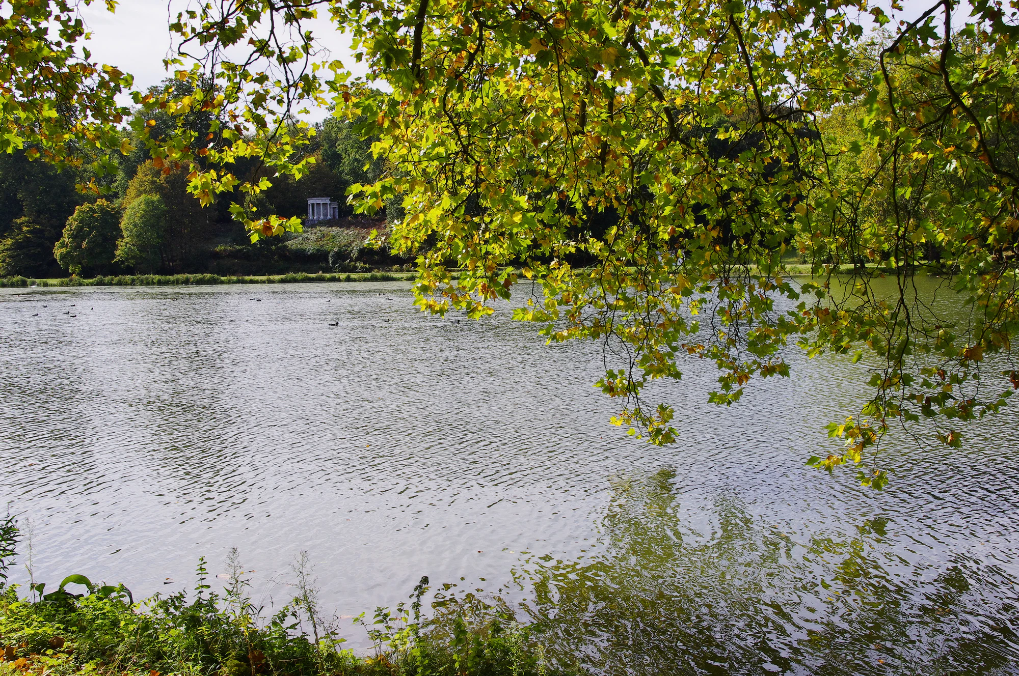
Parc Jean-Jacques Rousseau is a designed garden elsewhere within the regional park. Its water, meadows, wooded groups and small ornamental structures were arranged as successive views, influenced by landscape painting. Rousseau spent his final weeks at Ermenonville and was buried on the Île des Peupliers from 1778 to 1794. Treat this as a separate visit with its own opening arrangements. The photograph below shows this garden in October 2012, not the Commelles route.

Green and yellow leafy branches overhang a lake, with a wooded opposite bank and a small classical stone structure in the distance.

The grand lake in Parc Jean-Jacques Rousseau at Ermenonville, photographed in October 2012. This is a separate garden within the regional park, not the Étangs de Commelles.

“Ermenonville - Parc Jean-Jacques Rousseau - Le grand lac” — Patrick (Morio60), CC BY-SA 2.0. Source: https://www.flickr.com/photos/morio60/8192998902/. License: https://creativecommons.org/licenses/by-sa/2.0/. Original photograph unchanged. · Creative Commons

When to visit

Spring: a living shoreline

The pond margins are worth watching as the season changes, with amphibians moving to breed and birds using the wetland habitats. Evening road protection can be put in place during amphibian migration, particularly around March. Observe from the path; do not handle animals or use the event as a reason to stand in the road.

Summer: leave space in the plan

Bring enough water for the entire outing and choose a pace that suits the least heat-tolerant person in the group. Shade varies around the water. A single pondside pause can be more rewarding than adding another forest to an already warm day. Avoid fires and barbecues, and follow any temporary access restrictions.

Autumn and winter: plan the date first

The park’s September 2026 notice gives a general hunting season from 20 September to 28 February, with exceptions for particular species or periods. Check the current lot-specific information, not just that broad date range. A municipal society’s calendar may cover different land from Chantilly forest. Daylight, wet paths and posted notices should determine when and where you walk.

Getting there and practical advice

Parking and a picnic stop

The 2026 redesign moved parking away from the pond banks and created replacement areas at the site entrances. Follow the new signs rather than an old photograph or a remembered waterside space. Oise Tourisme lists free parking, a picnic area and refreshments. Bring your own essentials; café opening, toilets and drinking-water availability should be checked separately.

Maison du Parc: useful on weekdays

At Château de la Borne Blanche, 48 rue d’Hérivaux, Orry-la-Ville, the Maison du Parc houses the staff and welcomes visitors for information and local products. The current listing gives Monday–Thursday 08:30–12:30 and 13:30–17:30, and Friday 08:30–12:30 and 13:30–16:30. Check holiday exceptions before making a special trip. Plan weekend walks with information downloaded in advance.

If you choose the Ermenonville garden

The Département de l’Oise lists free entry at 1 rue René de Girardin, Ermenonville, from the first Wednesday in April to the last Sunday in October. Published hours are Wednesday–Sunday, 11:00–18:00, extending to 10:00–20:00 in July and August. Recheck the operator page before travelling, including any exceptional closure. These hours belong only to Parc Jean-Jacques Rousseau.

By train

Orry-la-Ville–Coye is the useful gateway for a walk to Commelles; the park’s destination page links a station-based itinerary. La Borne Blanche serves the Maison du Parc. Check RER D or TER services for the actual stopping pattern and return journey. Transilien identifies these stations as outside Île-de-France fare coverage: verify your ticket rather than assuming your usual pass applies. The station approach adds distance to the 5.2 km pond circuit.

By car

Set the destination to the Commelles visitor approach near route des Étangs and the château de la Reine Blanche, then follow current entrance-parking signs. A broad search for the regional park can take you to its office instead. Around spring amphibian migrations, respect any evening road barriers and use the signed diversion.

Match the route to the person

Ask about the surface, steps, gate width, suitable parking and accessible toilets at your intended starting point. Neither the “easy” rating nor the new parking establishes an accessible circuit. For a mixed-mobility group, agree on a comfortable turnaround point and a shared activity near the start.

Water and woodland conditions

Choose stable stopping places with space for other walkers to pass. Reeds can hide the edge of the water, and leaves can conceal roots or wet patches. After prolonged rain, shorten the visit rather than stepping off the established path to bypass mud; in strong wind or a storm, postpone the forest walk.

Sources and useful links

Wildlife you might spot

4

Each card links to a full Explore page with photos, traits, and fun facts.

Snap map for this place

Start with the big picture, then zoom in to explore individual wildlife observations around this place.

Loading map…

Good to know before you go

Save the official route page and map before setting off.

Use designated entrance parking; former bank-side spaces have been removed.

Check hunting information for the exact forest and lot, then obey signs on arrival.

Pack water, a snack and grippy shoes. Confirm facilities you need before travelling.

Watch without feeding wildlife, keep dogs close and give anglers room.

Leave logs, bark, plants and fungi where they are; photograph details instead.

Frequently asked questions

No. It covers a lived-in territory with many towns, forests and landowners. Choose the entrance for your intended outing. For this guide, the practical destination is the Étangs de Commelles near Coye-la-Forêt and Orry-la-Ville.
Oise Tourisme lists independent visits and parking as free. That does not override temporary restrictions, and it does not include tickets for other attractions elsewhere in the regional park.
The wider park is important woodland habitat, but a daytime pond walk is not a deer encounter. Choose the visit for its landscape, waterbirds and trees; enjoy any wildlife sighting without approaching or following the animal.
This itinerary is presented as a walking route. The wider forest has other users, but permitted access can vary by path and waterside section. Check the signs and an appropriate current cycling or riding itinerary instead of assuming the walking circuit is suitable.

Recent snaps at this place

Recent snaps will appear here as new observations are added.

View all ›

Take the discovery with you

Exploring Oise–Pays de France Regional Nature Park?

Identify the wildlife you spot, learn as you go, and keep a collection of the adventure.

  1. 1Spot it
  2. 2Snap it
  3. 3Keep the discovery









