Snappit logo
Snappit
Get App
Generic illustration, not a photograph of this venueIllustration
ParkNormandie, FR

Calvados Jurassic Cliffs National Nature Reserve

The rewarding detail here is the change of scale: houses stand behind a low cliff, yet the rocks beneath them record ancient seabeds.

About

The rewarding detail here is the change of scale: houses stand behind a low cliff, yet the rocks beneath them record ancient seabeds. Cap Romain lies between Bernières-sur-Mer and Saint-Aubin-sur-Mer on the Côte de Nacre. Its limestone contains fossil sponge colonies, while younger deposits above belong to a very different, colder world. You do not need to climb the cliff or take a fossil to appreciate that contrast. A clear view, binoculars and the interpretation panels are a better starting point.

Since September 2026, Cap Romain has formed part of the Réserve naturelle nationale des falaises jurassiques du Calvados. The new reserve brings six separate sectors under one designation, covering approximately 1,877 hectares, much of it maritime. This guide concentrates on Cap Romain; the other sectors need their own access planning. A protected coastline is not a continuous public walking route.

Give the living shore equal attention. Seaweed, birds and coastal plants share this changing edge with the fossils. The tide determines which surfaces are visible, and erosion determines what survives. That makes a modest observation visit more rewarding than trying to cover every rock: look at the whole cliff first, then choose one geological feature and one living subject to study without disturbing either. Enhance your adventure: download the Snappit app to identify the local species you encounter.

Cap Romain takes its name from Roman and Gallo-Roman occupation discovered around the headland. Its rocks are far older: the fossil-bearing formations belong to the Bathonian, within the Middle Jurassic. The site was already being studied in the nineteenth century and gained national reserve protection in 1984. The September 2026 designation replaced that former reserve with the wider Calvados Jurassic Cliffs reserve.

What to do here

Begin at the Brèche des Acadiens in Saint-Aubin-sur-Mer, an access identified in the manager’s 2026 programme. Read the local signs before deciding whether to descend. If the beach approach is open and conditions allow, observe Cap Romain from the permitted beach, clear of the cliff and its exclusion areas, then return by the same access. A guided geology outing is the best way to make sense of the less obvious fossil structures.

Seasonal info

The Cap-Romain visitor listing describes year-round visiting. In practice, tide, wind, waves, cliff conditions and temporary restrictions decide whether the beach visit is suitable. Seasonal guided events have their own dates and booking arrangements.

Accessibility

The beach and rocky foreshore are not a reliable step-free route: sand, loose stones, wet surfaces and changing tidal conditions matter. For a wheelchair, walking aid or pushchair, ask the tourist office about the current approach and an appropriate paved-seafront alternative before travelling.

Don't miss

1

A fossil sponge reef preserved in Jurassic limestone

2

A compact coastal visit between two seaside towns

3

Living shore communities beside evidence of ancient seas

4

A fresh view of a six-sector national nature reserve

Walks and routes

Cap Romain from the Brèche des Acadiens

Use the signed public access at the Brèche des Acadiens, on the Saint-Aubin-sur-Mer side. Before leaving the access area, identify your return, read the notices and check that enough permitted beach remains clear of water and cliff exclusions. Keep the outing to the nearby viewing area; do not turn it into a crossing to Bernières or an expedition across the offshore rocks. From a safe position, compare the low cliff, the rock platform and the sea. Return by the same open access while your chosen tidal window still leaves a generous margin.

This suggested out-and-back is on a tidal shore, with variable footing rather than a surveyed accessible trail. The manager’s programme also names the cannon staircase at place du Canada, which involves steps; it is not a step-free substitute. Ask locally about the Brèche des Acadiens approach before bringing mobility equipment.
Cap Romain from the Brèche des Acadiens

A short family visit with one clear goal

Before setting out, choose a goal such as understanding the sponge reef or watching the shore birds. Spend the first few minutes at the access signs, the middle of the visit observing from an allowed position, and the final part returning before anyone is cold or tired. Let children choose one sketch or photograph to explain afterwards. Keep snacks for a comfortable spot back in town, rather than making a long stop near the cliff.

Things to try

Read three different landscapes in one view

Start with the broad layers rather than a hunt for individual fossils. The limestone belongs to a marine world; the younger gravels and brown silts above tell another story. Make a quick sketch using three bands, then use the interpretation panel to test what each represents. Leave blank anything you cannot identify from your safe viewing point. A good field sketch records uncertainty as well as discoveries.

Imagine the sponge community

Fossil sponges occur as plates, cups and irregular stacked forms, with other small creatures once living around them. Use the panel illustrations or a guide’s explanation to picture an inhabited seabed, rather than isolated objects in stone. Try drawing the ancient scene beside a sketch of today’s shore: what has changed in habitat, scale and visibility? Keep any close inspection to a guide-approved location.

Keep a five-minute shore notebook

Choose one spot away from other visitors and watch without moving closer. Note where birds feed or rest, where seaweed remains wet, and which surfaces are exposed. A photograph with the time and tide stage can be more useful than a bag of souvenirs. Do not lift stones, pull seaweed aside or approach birds to improve the picture.

Join a geology outing

Ask Cœur de Nacre Tourisme for the next Cap-Romain geology visit. The reserve’s published programme has included meetings with the conservator and sessions about ancient and present-day marine life. Bring a hand lens if requested, but let the guide choose where and how to observe. Confirm whether booking is needed and allow the organiser to change plans for tide or weather.

Saint-Aubin-sur-Mer’s town heritage

For an ordinary damp day with no coastal hazard, use the tourist office’s town discovery leaflet to explore the fishing lanes and seaside architecture. The published complete circuit is 3 km with an indicated one-hour walking time, but it includes steps and shore-related points, so choose only suitable open streets rather than treating it as an all-weather accessible loop. In storm or flooding conditions, choose an indoor plan away from the coast.

Saint-Aubin-sur-Mer’s town heritage

Wildlife and habitats

Sea rocket

Look for thick, fleshy leaves and, when flowering, small flowers with four white or pale lilac petals. Sea rocket tolerates salt spray and brief seawater inundation. View it from the permitted beach edge, without stepping into the plants; its seasonal growth means it will not always be conspicuous.

Herring gull

An adult’s pale grey back, pink legs and sturdy yellow bill with a red spot are useful clues. Young gulls look browner and are harder to identify. Watch behaviour as well as colour: resting, feeding and flying give different views of the same bird. Avoid using food to bring gulls closer.

Black-headed gull

The name can mislead: breeding adults wear a chocolate-brown hood, while outside the breeding season the head is pale with a dark ear spot. Look for the red bill as another clue. Comparing gulls through binoculars is a satisfying activity even when you cannot identify every individual.

Eurasian curlew

A long, downcurved bill, long legs and brown plumage make this a distinctive shorebird; its bubbling call is memorable too. Curlews have been recorded here, though a short visit may miss them. If birds are feeding or resting ahead, choose another viewing position rather than making them move.

Stories and discoveries

A reef with different builders

Cap Romain’s celebrated reef was built by sponges. Their preserved arrangements help show how an ancient community occupied the seabed before sediment buried it. Bryozoans and other marine remains add detail to the limestone: the value lies in their relationships and position, not simply in finding an attractive fossil.

The cliff does not tell one continuous story

Younger deposits sit above the Jurassic rocks. Marine gravels record a later shore, and windblown silts relate to cold Quaternary conditions. Large granite and sandstone boulders on the rock platform, locally called gas, have been interpreted as material transported by floating ice. Do not walk out to one simply because it is visible: distant features can be enjoyed through binoculars.

Vegetation helps protect the geology

The small dunes and rooted cliff-top vegetation are part of the site’s protection. Lyme grass, Leymus arenarius, is recorded here and helps hold sand. Keeping to permitted routes protects living cover as well as fossils; a shortcut through vegetation can damage both layers of the site.

Why a low cliff still needs respect

A BRGM investigation after a past collapse found that fractures and undercutting could release limestone slabs and disturb the softer material above. Rain and freeze–thaw conditions can contribute. The cliff’s modest height is no assurance of stability, and an old photograph cannot show today’s safe boundary.

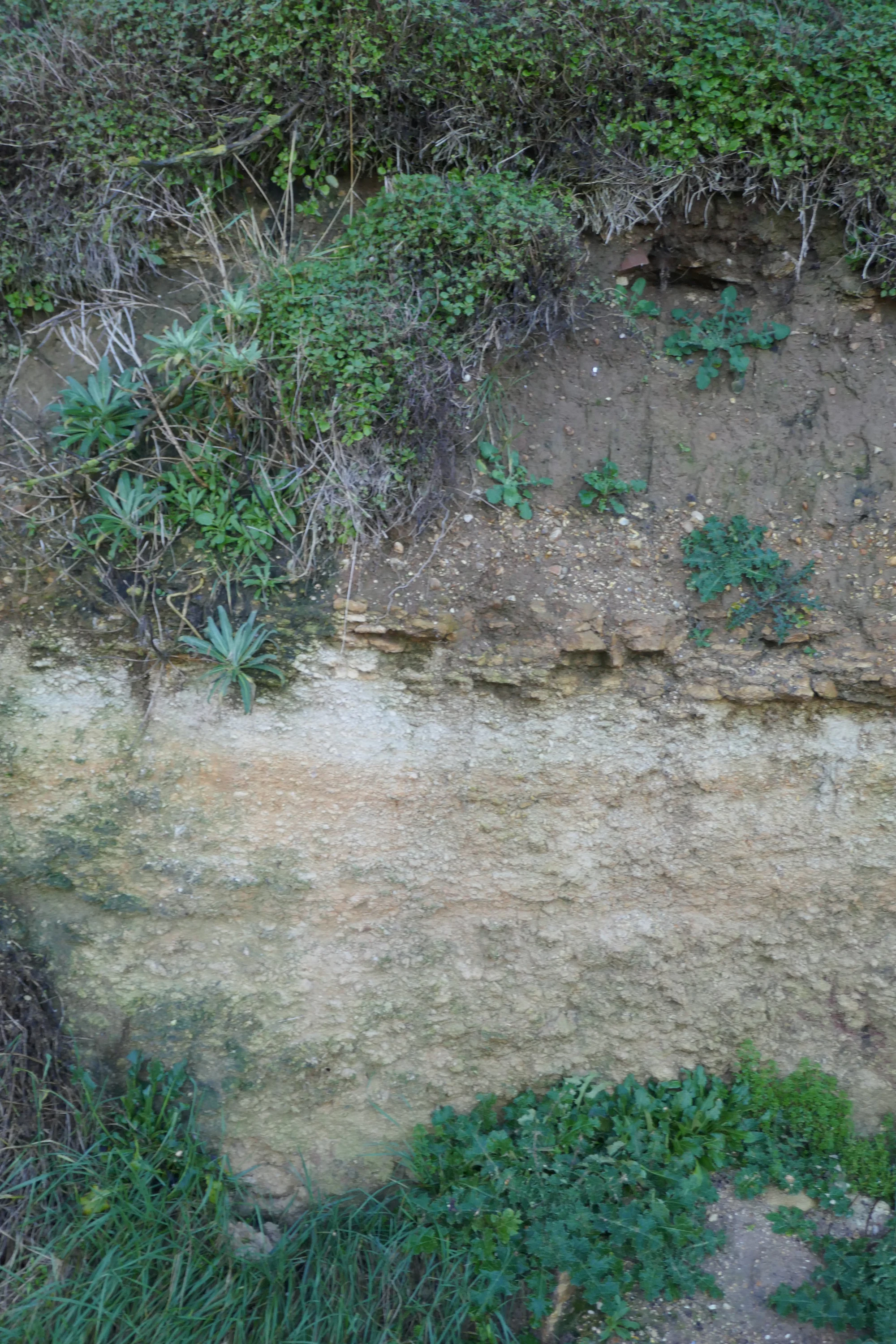
A narrow band of pebbles lies between pale rock and darker soil, with vegetation above and beside it.

A detail of Cap Romain’s layered cliff materials, published in December 2020; the date of capture is unknown. This photograph does not show present-day cliff conditions or a safe approach.

“Plage fossile de Cap Romain” — Lionel DUCHOISELLE, CC BY-SA 3.0. Source: https://www.geodiversite.net/media1926. License: https://creativecommons.org/licenses/by-sa/3.0/. Original photograph unchanged. · Creative Commons

When to visit

A calm day in spring or summer

Use the longer daylight to choose a comfortable tidal window, rather than squeezing the visit around lunchtime. Take sun protection as well as a windproof layer. If a guided session is available, organise the rest of the day around its actual meeting time.

Autumn and winter

Make the outing shorter and keep a dry alternative ready. A shore that looks interesting after rough weather may also have fresh falls, debris or slippery surfaces. Watch birds from a distance, and turn back early if the group is getting cold. Tide predictions must be considered alongside the marine weather and current notices.

Getting there and practical advice

Interpretation and practical stops

The departmental listing identifies educational panels, a reading table, parking and the Croisette picnic area. These are aids to planning, not a promise that every installation or space is available on arrival. Use signed parking and check its local conditions. Plan toilets, water refills and food stops in town; do not rely on finding them on the shore.

By bus from Caen

NOMAD line 101 links Caen with the coastal towns, including Saint-Aubin-sur-Mer and Bernières-sur-Mer. Check the current direction, stop and return journey on the operator’s page; not every service has the same pattern, and some require advance reservation. Allow a separate walk from your chosen stop to the access. Temporary changes in Caen can affect the journey even when the seaside stop is unchanged.

By bus from Caen

Arriving at the shore

For this visit, navigate to the Brèche des Acadiens in Saint-Aubin-sur-Mer. The regional listing’s Chemin du Cap Romain address is on the Bernières side, so check which entrance your navigation app has selected. Use public streets and signed access points; the reserve name is not permission to cross cliff-top gardens or private land.

Make the visit fit your group

Tell the tourist office what you need: a continuous firm surface, no steps, a short approach or a place to sit. Ask which interpretation can be reached without going onto sand. For anyone unsteady on wet ground, a town-based view or an indoor explanation may be the better choice. Do not assume that a generally accessible seaside town makes the reserve’s foreshore accessible.

Sources and useful links

Wildlife you might spot

4

Each card links to a full Explore page with photos, traits, and fun facts.

Snap map for this place

Start with the big picture, then zoom in to explore individual wildlife observations around this place.

Loading map…

Good to know before you go

Use the tide information for this Calvados coast; do not confuse it with Saint-Aubin-sur-Mer in Seine-Maritime.

Wear footwear with grip and bring a windproof layer, drinking water and binoculars.

Keep children close on the beach and let adults check access, sea conditions and the return route.

Stay outside all fenced or signed exclusions; never climb the cliff or cross fallen material to get a closer look.

Leave fossils, stones, sand, plants and animals where they are. Photograph or sketch your discoveries.

Keep dogs on a lead and give feeding or resting birds plenty of space.

Frequently asked questions

No. Ordinary visitors must not collect fossils, rocks, sand, minerals or concretions. A loose specimen is still part of the protected site. Scientific and educational exceptions in the decree require the appropriate management or authorisation arrangements; they are not permission for personal collecting.
Do not plan it as one continuous walk. The six sectors are separate, and cliff, tidal, property and local access restrictions differ. This guide’s short Cap-Romain visit does not establish access to the Bessin cliffs, Vaches noires or the other sectors.
You can make a short independent observation visit where signs and conditions permit. Follow the signs on arrival. For close geological interpretation, choose a published guided outing and check its meeting point, availability and conditions with Cœur de Nacre Tourisme.
Skip the shore section. If conditions are calm enough for an ordinary town walk, explore Saint-Aubin-sur-Mer’s streets and seafront instead. During coastal flooding or wave warnings, keep away from the seafront too.

Recent snaps at this place

Recent snaps will appear here as new observations are added.

View all ›

Take the discovery with you

Exploring Calvados Jurassic Cliffs National Nature Reserve?

Identify the wildlife you spot, learn as you go, and keep a collection of the adventure.

  1. 1Spot it
  2. 2Snap it
  3. 3Keep the discovery