Snappit logo
Snappit
Get App
Generic illustration, not a photograph of this venueIllustration
ParkExtremadura, Spain

Garganta de los Infiernos Nature Reserve

Garganta de los Infiernos is more than its famous rock pools.

About

Garganta de los Infiernos is more than its famous rock pools. This mountain reserve rises from the Jerte valley through oak and chestnut woods to broom-covered slopes and high grassland. Water connects the landscape: rain and melting snow feed streams that have cut channels, cascades and rounded hollows into hard rock. Los Pilones is the best-known place to see that work, but a visit does not have to include a swim or a long hike.

Make the Los Arenales interpretation centre your starting point, provided you have confirmed it is open. Its models and displays explain the reserve’s habitats and the formation of the granite bowls. It is a useful first stop for children and for anyone who wants to understand the landscape before choosing how far to walk. Ask staff about the day’s path conditions and a short outing that suits your group.

If everyone is comfortable with a sustained climb and uneven ground, follow the signed route to Los Pilones and return the same way. Budget for about 6 km of walking, plus any approach from your parking space. The oak woodland is part of the experience, so leave time to pause rather than treating it as an obstacle between you and the pools. The 16 km reserve circuit is a separate full-day commitment, not a small addition to the family walk. Be ready to snap and learn! Get the Snappit app to identify any nature species you find here.

The reserve was declared in November 1994 to protect the natural character of this part of the Jerte mountains. Its current planning framework was renewed in 2025, with a resource plan in July and a use-and-management plan in December. The legal boundary description covers 7,266 hectares in Cabezuela del Valle, Jerte and Tornavacas. The woods also tell a human story. Chestnut stands were established in places once occupied by oak, and timber, fruit, livestock and terraced crops have helped shape the landscape. The reserve protects a living countryside as well as its streams and wild habitats. Cherry orchards in the surrounding valley are cultivated land, so admire them from public routes and leave the fruit alone.

What to do here

Explore the interpretation displays, compare the woodland and stream habitats, and choose a walk that leaves everyone enough energy for the return. At Los Pilones, enjoy the smooth granite shapes from secure footing. Binoculars and a simple leaf-and-rock spotting game can make a dry-land visit just as absorbing as a summer outing.

Seasonal info

Rain and snowmelt can make the gorge forceful; summer brings heat, busy parking and fire risk. Autumn’s wet leaves and winter frost can make the path slippery. Check the forecast, centre arrangements and any access notice for your date. Permission to bathe in a designated stretch does not establish safe conditions on the day.

Accessibility

Treat the centre and the trails as separate access questions. Ask about step-free entry, toilets and parking before relying on the building for an accessible visit. The uphill Los Pilones trail and uneven rock around the pools are not a step-free promenade. Do not assume it suits a wheelchair, pushchair or someone with limited balance; discuss a shorter alternative and any authorised vehicle-access arrangement with the reserve.

Don't miss

1

Los Arenales interpretation centre

a manageable introduction to water, woodland and mountain habitats, when open.

2

Los Pilones

rounded granite basins that make river erosion easy to picture.

3

Oak and chestnut woodland

changing shade, leaves and signs of a long-used landscape.

4

Stream and mountain wildlife

look quietly from public paths and learn how different habitats support different species.

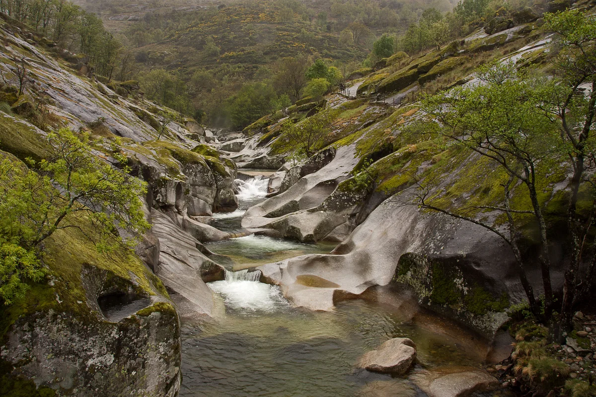
A stream cascading through smooth rock pools at Los Pilones, bordered by mossy granite and young green foliage.

Los Pilones in the Reserva Natural de la Garganta de los Infiernos, photographed in April 2019.

Garganta del infierno en el valle del Jerte 2019An001.jpg — Anual / Wikimedia Commons / CC BY-SA 4.0 · Creative Commons

Walks and routes

Los Pilones from Los Arenales: the usual first walk

Start at the interpretation centre and follow the yellow-and-white signed route through oak woodland, passing the Chorrero de la Virgen viewpoint on the approach to Los Pilones. The main reward is the contrast between shaded trees and the broad, water-worn rock. Return along the same route, resisting the temptation to follow the longer circuit unless you planned and equipped for it. Add the distance from your actual parking place.

About 6 km out and back from the centre. Official outward leg: 3 km, 45 minutes. Allow 2½–3 hours including stops.

The local page rates the route medium-low and reports 234 m of ascent/descent. Expect a real uphill walk and uneven ground, followed by the descent back. Ask staff about any difficult sections for your group. Wet rock at the pools requires particular care; this is not a default pushchair or wheelchair route.


Los Pilones from Los Arenales: the usual first walk

Los Pilones from Jerte: a town-based alternative

Cross the bridge by Parque El Nogalón in Jerte and follow the green-and-white marks for the published Los Pilones approach. This can suit visitors already staying in the village, but it adds distance compared with starting at the centre. Return to Jerte by your outward route. Walking down to Los Arenales instead needs a separately arranged onward journey.

About 8 km out and back. Official outward leg: 4 km from Jerte. Allow 3–4 hours with stops.

Officially medium-low difficulty, but longer than the centre route. Allow for climbs, unpaved terrain and the same water-edge hazards at the destination. Confirm current surfaces and gradients for your needs; do not treat a village start as an accessible-trail guarantee.

Los Pilones from Jerte: a town-based alternative

Garganta de los Infiernos circuit: a full walking day

The longer yellow-and-white route continues beyond Los Pilones through the gorge landscape, linking the Puente del Carrascal and Puente Nuevo area before returning through woodland. Choose the signed centre-start circuit and return to that same start. Several named routes meet here, so follow the complete official description rather than collecting individual bridge waypoints.

Official circuit: 16 km, about six hours. Allow 7–8 hours with breaks and a generous daylight margin.

The local page reports 718 m of ascent/descent. Length, repeated climbs and uneven mountain paths make this a substantial outing even though the page’s overall difficulty category is medium-low. It is not the suggested visit for small children, limited mobility or a first uncertain-weather walk.

Garganta de los Infiernos circuit: a full walking day

A light visit: centre first, walk optional

Confirm the centre’s opening and allow 45–60 minutes for its displays. Ask staff for a short current option that suits everyone, with a clear turnaround point. If the surface, weather or energy level is wrong, finish with the indoor visit and a meal in a valley village. Reaching Los Pilones is not required to have seen something worthwhile.

A half day with confident walkers

Arrive with your parking plan settled, visit the centre if its opening fits, then take the 6 km return route to Los Pilones. Carry lunch or snacks and water, set a turnaround time and leave the afternoon flexible. Enjoy the rock from a safe vantage point and return along the same route.

A full day for experienced walkers

Choose the 16 km circuit before departure, check conditions and study the junctions. Carry what you need for the whole day and allow 7–8 hours with breaks. Keep the route within your daylight and fitness margin; do not add a swim or an improvised mountain detour to an already long outing.

Things to try

Let the model explain the real river

In the centre, compare the model of Los Pilones with the woodland and water you may see outside. Ask children what a stream carries besides water, then look for the difference between a rounded hollow and a rock crack. The explanation works even if you decide not to hike to the pools.

A forest stop with three things to notice

At a safe place beside the route, stop for five quiet minutes. Find one leaf shape, one bird sound and one patch of changing light. Photograph what you notice instead of picking it up. A small observation task gives the walk its own purpose, even if you turn back early.

Photograph the rock from a stable place

Frame water, rounded granite and woodland without edging onto wet slabs. Keep the path clear and put the camera away before moving. Professional filming and photography require reserve authorisation; drone flights also have specific permit rules, so leave a casual drone flight out of the plan.

Make interpretation the main activity

If the centre confirms it is open, use the models and habitat displays for an indoor introduction. Have a separate village plan if it is closed. Do not replace a rain-affected gorge walk with another watercourse merely because it is closer to the road.

Turn back before a difficult crossing

During heavy rain, storms, rising water or icy conditions, postpone the gorge walk. If a path is flooded or a crossing feels unsafe, return by a safe known route and seek staff advice. The aim is a comfortable day out, not completing a line on a map.

Wildlife and habitats

Introduced and managed woodland

Look at the long, toothed leaves and, in season, the prickly cases from the path. Leave nuts and branches where they are; the trees belong to a working landscape.

Wild stream bird

From a secure path-side viewpoint, watch for a compact bird with a bright chest near fast water. Give it room to feed and never approach a nest or enter the channel for a better look.

Wild stream fish

If you can look into the water safely from the path, pause and watch rather than leaning over an edge. Moving reflections can make fish hard to distinguish. Do not feed fish or disturb the streambed.

Wild river mammal

An otter is an elusive possibility. Use the riverbank habitat to talk about shelter and clean water, and stay on the route rather than searching banks or following an animal.

Wild woodland amphibian

Look at damp woodland from the path without turning logs or stones. If a salamander crosses in front of you, stop and let it pass. Photograph without handling it and keep pets away.

Wild soaring bird

Scan the open sky from a comfortable stopping place for broad-winged birds circling overhead. Binoculars help; leave cliffs and nesting places undisturbed.

Wild mountain mammal

This is mainly a species of the wider mountain landscape. If one is visible from an authorised route, watch at a distance and leave an escape route. Do not extend a family walk uphill just to search for it.

Enjoy the habitats as well as the animals you happen to see. Sightings vary with season, weather and disturbance. Stay on public routes, keep your distance, avoid playback or feeding, and leave nests, dens, plants and stream stones undisturbed.

Stories and discoveries

A river can use stones as tools

At Los Pilones, swirling water carries small stones around hollows in the granite. Repeated abrasion enlarges the bowls called marmitas de gigante, or giant’s kettles. Their smooth appearance is a clue to the water’s work, not evidence that the rock is safe to walk on.

The stream has two seasonal water sources

The national river-reserve description identifies a rain-and-snow-fed regime. A bright day at valley level does not tell the whole story of water arriving from higher ground, which is one reason to check conditions before approaching the gorge.

Chestnut woods have a history of use

The reserve’s resource plan describes chestnut replacing oak in some stands, with coppice stems grown for timber. A leafy woodland can therefore be rich in nature while also carrying the marks of generations of work.

When to visit

Spring: water and fresh leaves

Keep the walk flexible after rain or during snowmelt. Enjoy the woodland and flowing-water views from secure ground, and choose the centre if conditions make the gorge a poor idea. If you also want cherry blossom in the valley, check that year’s timing separately.

Summer: make an early, modest plan

Start before the hottest part of the day, carry water for the whole return and expect more demand for parking. Follow current fire and access restrictions. Decide whether the walk itself suits the heat; a possible swim later is no substitute for a safe walking plan.

Autumn: allow time for the way down

Woodland colour can make a slow visit particularly rewarding. Wet leaves and rock need care, and daylight shortens. Pack a layer, allow extra time for the descent and leave chestnuts and other produce for the people and wildlife that use them.

Winter: keep to conditions you can manage

Snow in the higher reserve does not mean the valley routes are automatically safe. Frost, wet surfaces and short daylight can make even the lower walk unsuitable. Confirm indoor opening and choose a short visit rather than treating the 16 km circuit as an all-season family option.

Getting there and practical advice

Los Arenales interpretation centre

The centre is at the reserve’s main approach off the N-110 at kilometre 368, between Jerte and Cabezuela del Valle. Displays cover the reserve and valley, with a Los Pilones diorama and an audiovisual space. Ask which rooms and activities are available on your date; school-group visits should be arranged ahead. Contact: +34 927 014 936. The local reserve page also lists [email protected].

Food, toilets and drinking water

Sort out food, drinking water and a toilet stop before walking, using confirmed services in the gateway villages or entrance area. Ask the centre about toilets and their accessibility when you call. Do not rely on a café, a fountain or toilets being available at Los Pilones.

Parking at the main approach

Use the signed car park beside the N-110 access roundabout and check the current charge and any capacity arrangement. The tourism notice gives a paid period from mid-March to late October. Do not leave a car on the prohibited stretch between Jerte’s football ground and the campsite, or block gates and emergency access.

Approach by the N-110

Navigate to the Los Arenales interpretation centre or its signed access parking, not to an arbitrary pin in the mountains. The N-110 links the Jerte valley towns and the approach from Plasencia. Follow the reserve’s entrance signs, then continue on foot unless you have specific authorised access.

Using buses or a taxi

Spain.info mentions a bus connection from Plasencia to the valley towns, but check the operator’s timetable and the return for your date. A stop in Jerte is not a stop at the centre. Arrange the last leg and pickup in advance, or plan the longer signed Jerte walking approach if it suits everyone.

Keep your return simple

For the centre route, walk back to the centre; for the Jerte route, walk back to Jerte. Treat a different finishing point as a transport decision requiring an arranged lift or taxi. Do not assume that an authorised 4×4 service will have a spare return seat at the pools.

Ask about the complete centre visit

When calling Los Arenales, describe the help or equipment you use and ask about parking-to-door access, steps, usable toilets and seating. Confirm the building is open before travelling. The available descriptive pages do not provide enough detail to promise an independently accessible visit.

Los Pilones needs a separate decision

The main path climbs through woodland, and the pool area adds uneven, potentially slippery rock. A low or medium-low walking grade does not answer questions about gradients, width, wheel access or balance. Ask staff for a suitable shorter experience if those barriers matter to you.

Authorised vehicle access is possible in principle

The current management plan allows vehicle-access authorisations to help people with reduced mobility. Contact the reserve beforehand to ask whether an arrangement can be made for your date and what it actually reaches. Permission, a suitable vehicle, transfers and access at the destination all need checking.

Check the centre before you leave

As checked on 17 October 2026, the local tourism page advertises 08:00–15:00 daily. An older Junta guide gives morning and seasonal afternoon hours, while the race website retains an undated renovation-closure note. Call +34 927 014 936 to confirm opening and available rooms; do not rely on either the old timetable or the undated closure as a definite answer.

Walking, groups and temporary restrictions

Independent walking is permitted in the reserve’s public-use areas under the December 2025 management plan. Staff can impose temporary restrictions or capacity limits. Organised activities and commercial guiding require their own authorisation, and public access does not extend indiscriminately into every part of the reserve. Ask before planning an organised group visit.

Understand the bathing limits

The management plan allows bathing only in specified places. At Los Pilones, the named stretch runs from Charco del Pontón to about 375 metres upstream. Ask staff to identify the limits and check current signs. Other attractive pools elsewhere in the reserve are not automatically open for bathing. Pets must remain restrained and out of the water in the designated bathing areas.

Keep water safety separate from permission

Plan to enjoy Los Pilones from dry ground. If considering the water, first check weather, flow, access, exit points and any health or closure notice. Do not swim in strong or rising flow, after heavy rain or during a storm. Cold water, underwater obstacles and smooth wet rock can be dangerous even in an allowed area. Never jump, dive or use a rock chute as a slide; keep children within immediate reach and do not depend on rescue staff being present.

Respect the reserve’s activity rules

Fires and barbecues are prohibited, and camping or overnighting is restricted to places designated for it. Canyoning, rafting, climbing and navigation are generally incompatible with the reserve’s rules; activities advertised elsewhere in the Jerte valley do not establish permission here. Professional photography and drone flights need the relevant authorisations.

Sources and useful links

Wildlife you might spot

7

Each card links to a full Explore page with photos, traits, and fun facts.

Snap map for this place

Start with the big picture, then zoom in to explore individual wildlife observations around this place.

Loading map…

Good to know before you go

Call the centre on +34 927 014 936 before building your day around it. The local tourism page lists daily 08:00–15:00 hours, but published schedules and an undated renovation notice conflict.

Count the return

the local route page gives 3 km each way to Los Pilones from the centre. Starting from Jerte makes it 4 km each way; these are different approaches.

Use marked parking and check the tariff. The local notice says the N-110 roundabout car park charges from mid-March to late October, and prohibits roadside parking between Jerte’s football ground and Camping Valle del Jerte.

Wear shoes with grip and carry drinking water, food and a waterproof or warm layer. A stream or roadside spring is not a guaranteed drinking-water supply.

Keep children close beside water and drops. Stay off slippery rock, never jump or dive into the pools, and leave the water out of the plan after heavy rain, during storms or whenever conditions are uncertain.

Take a picnic that needs no flame

fires and barbecues are prohibited. Carry every scrap of rubbish out and do not wash equipment with detergent in the natural environment.

Keep dogs on a lead and under control. In designated bathing areas, pets must stay out of the water as well as remain restrained.

Save the route before setting off, tell someone your plan and turn back while everyone still has time and energy. Follow closures and staff instructions; call 112 in an emergency.

Frequently asked questions

No. A confirmed visit to the Los Arenales centre can be worthwhile on its own. Ask staff about a short nearby outing suited to the day and your group. Do not turn a hoped-for short visit into the 6 km return walk simply because the pools are famous.
The local route authority gives 3 km one way from the interpretation centre, so about 6 km out and back, before any extra parking approach. It publishes 45 minutes for the outward leg; allow 2½–3 hours for a relaxed return walk with stops. From Jerte, the separate signed approach is 4 km each way.
The December 2025 reserve plan permits bathing only in named stretches, including the Los Pilones section from Charco del Pontón to about 375 metres upstream. Ask staff to identify the permitted limits and any temporary restrictions. Allowed bathing is not a safety guarantee: check water and weather conditions, keep children within immediate reach, and do not jump, dive or rely on a lifeguard being present.
Ordinary visitor cars cannot use the interior tracks as an unrestricted route to the pools. The management plan allows specified exceptions and permits, including authorised tourism services and access for people with reduced mobility. Arrange any such access with the reserve or an authorised operator before travelling; do not follow another vehicle through a barrier.
The current management plan allows independent walking in public-use areas, subject to temporary limits and local signs. Organised activities, commercial guiding and access outside public-use areas have separate authorisation requirements. Ask the reserve about your particular group or activity rather than assuming every path is open to everyone.
No: the published Jerte approach is longer, at 4 km one way from the bridge by Parque El Nogalón. Return to the same starting point unless you have arranged a pickup. Returning to the centre instead leaves you in a different place.
Confirm directly before travelling. The official local page lists 08:00–15:00 every day, but older official brochures give different hours and a local event website retains an undated renovation-closure notice. The centre’s contact number is +34 927 014 936.
Yes, kept on a lead and under control in visitor areas. Pets are not allowed into the water in the designated bathing areas. Bring their water and remove their waste.

Recent snaps at this place

Recent snaps will appear here as new observations are added.

View all ›

Take the discovery with you

Exploring Garganta de los Infiernos Nature Reserve?

Identify the wildlife you spot, learn as you go, and keep a collection of the adventure.

  1. 1Spot it
  2. 2Snap it
  3. 3Keep the discovery