Snappit logo
Snappit
Get App
Generic illustration, not a photograph of this venueIllustration
ParkAragón, Spain

Moncayo Natural Park

Moncayo makes a very satisfying forest day without going anywhere near the summit.

About

Moncayo makes a very satisfying forest day without going anywhere near the summit. Start at Agramonte, where a former forest house introduces the mountain’s trees, birds and geology. If the ground and weather suit your group, follow the short AG2 walk towards Fuente de la Teja. A little time spent looking into the canopy, listening and stopping for a picnic is enough to make this a proper outing.

The mountain explains the woodland. Rising between the Ebro basin and the Castilian plateau, Moncayo catches moist air on its northern slopes. Oak, beech and birch woods occupy cooler, wetter ground, while pine plantations tell another part of the landscape’s story. Higher up, trees give way to low vegetation and open, weather-beaten ground. The highest summit, San Miguel, reaches 2,315 metres.

There is another Moncayo to the south. Around Calcena, Purujosa and Talamantes, limestone walls, ravines and more Mediterranean vegetation replace the northern forest setting. These places deserve a separately planned visit rather than a hurried detour after Agramonte.

This guide covers the Aragón natural park in Zaragoza province. The wider massif continues into Soria, but that neighbouring territory is not part of this park. The suggested first visit stays around Agramonte; the summit is a different undertaking, requiring mountain fitness, preparation and suitable conditions. Explore the grounds like a pro—download the Snappit app to instantly identify animals and plants.

Protection began in 1927 around the Dehesa del Moncayo. It became a natural park in 1978, expanded and took its present name in 1998, then grew again in 2007 around Talamantes and Purujosa. The protected landscape is much broader than the popular northern approach. Woodland use has left a visible legacy. Timber extraction, charcoal making and grazing changed the slopes, and reforestation introduced extensive pine stands. Today, native broadleaved woodland regenerating beneath those pines is part of the park’s conservation work. On the Peña Roya walk, the remains at Santa Lucía add a different clue to past lives: an old hermitage and a snow store.

What to do here

Visit Agramonte’s exhibition when open, then choose the AG2 Fuente de la Teja walk. Follow the signed junctions, pause in the woodland and use the designated picnic area. Keep the rest of the day flexible rather than adding a summit attempt.

Seasonal info

Wet leaves, mud, fog and ice can change the feel of a short woodland path. Avoid wooded walks during strong winds and exposed routes in storms. Snow or ice on the summit routes calls for winter mountaineering skills and equipment, not simply warmer walking clothes.

Accessibility

Agramonte lists accessible infrastructure, but its public page does not specify every entrance, toilet or surface detail. Call to discuss your needs. AG2 is a forest walk with climbing and path junctions, not an officially confirmed wheelchair route. Families with pushchairs should ask staff which immediate surroundings are suitable that day.

Don't miss

1

Agramonte’s forest interpretation and nearby picnic setting

2

A short walk through contrasting woodland towards Fuente de la Teja

3

Beech forest and the traces of older mountain livelihoods

4

Two contrasting landscapes

moist northern slopes and the limestone south

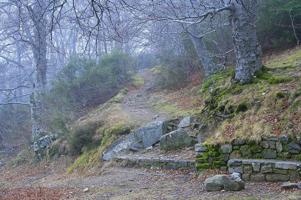
Bare beech branches arch over a rocky woodland path, with moss-covered stones, leaf litter and a low stone edge in the foreground.

Beech woodland on Moncayo in January 2011, with a rocky path disappearing into mist. The pictured path has not been identified as the recommended AG2 walk.

Moncayo entre la niebla.jpg — Miguel Ángel García / Wikimedia Commons / CC BY 2.0; Commons frame crop by Tyk · Creative Commons

Walks and routes

First choice: AG2 Agramonte–Fuente de la Teja

The Montaña Segura circular version is 2.1 km, with 90 m ascent and 85 m descent, and takes about 40 minutes of walking. It leaves the Agramonte visitor-centre surroundings, climbs through oak woodland, crosses the sanctuary access road and reaches the Fuente de la Teja recreation area among beech trees. Follow the marked return through the woodland rather than improvising a roadside shortcut.

Forest paths and a road crossing require attention. The route is described as family-friendly, but has not been verified as wheelchair-accessible; ask about pushchair suitability.


First choice: AG2 Agramonte–Fuente de la Teja

A longer woodland outing: S1 Hayedo de Peña Roya

From Fuente de Sacristán, the park’s S1 follows a forest track through beech woodland towards the remains of the Santa Lucía hermitage and snow store. The park route page gives 7.5 km total and 2 hours 15 minutes, labelled out-and-back. This is a separate longer walk, not an extension to squeeze into the short Agramonte visit.

A forest track is not a guarantee of step-free or wheelchair access. Expect weather-dependent footing and check current surface conditions and the intended turnaround with staff.

A longer woodland outing: S1 Hayedo de Peña Roya

For prepared mountain walkers: the Haya Seca summit circuit

Montaña Segura’s Haya Seca circuit is 9.7 km with 770 m ascent and descent and 4 hours 30 minutes of walking. It reaches the summit via the San Miguel cirque and Cerro de San Juan, then returns by Collado de Castilla. This is a strenuous mountain outing with rough ground and exposed upper slopes. The park also publishes a different 12.3 km return approach from Fuente de los Frailes; the two should not be mixed.

Unsuitable as a gentle or step-free outing. Rough, steep terrain demands mountain footwear, stamina and confident navigation.

For prepared mountain walkers: the Haya Seca summit circuit

A relaxed first morning

First, use Agramonte’s exhibition and ask about the paths. Then take AG2 if it suits your group and the conditions; allow time for the road crossing and nature stops. Finish with a picnic at an authorised area. If anyone is tired, the centre and its immediate surroundings can be enough.

A longer forest visit

Choose S1 Peña Roya as the main walk and keep the rest of the day light. Read the route sheet before leaving Fuente de Sacristán and give the old structures at Santa Lucía space. Add the centre only if its opening hours fit.

Come back for the southern side

Plan another outing around Calcena, Purujosa or Talamantes. Use the official trail network and the relevant centre to choose a route through the limestone country. Ravines, caves and longer circuits need their own access and safety checks.

Things to try

Make a three-tree notebook

Choose three trees visible from the path. Sketch a leaf or needle cluster, the trunk and the outline of the crown. Compare them after the walk using the centre’s interpretation; leave all material where you found it.

Try a quiet minute

Stop at a safe place off the line of walkers, without leaving the path. Count different sounds rather than trying to name every bird. On a second stop, notice whether the soundscape changes with the woodland.

Join a scheduled interpretation activity

Agramonte advertises seasonal walks and activities. Check the current agenda, meeting point, suitability and booking instructions rather than expecting a guide to be available on arrival.

Make the exhibition the visit

If Agramonte is open and the road is safe, spend time with its forest and geology displays instead of forcing a walk. Check first rather than driving up expecting an indoor refuge.

Change the day when needed

Strong winds, storms, ice or restricted road access are good reasons to postpone the mountain. Do not substitute an unplanned ravine walk or cave visit for the forest route.

Wildlife and habitats

European beech · Fagus sylvatica

Beech woodland is one of the northern park’s defining habitats. Compare the canopy above you with the quieter, more shaded forest floor. Fuente de la Teja and Peña Roya offer different-length ways to experience the beech setting; stay on the path and leave fallen wood in place.

Common hazel · Corylus avellana

Hazel is documented in the park’s wetter woodland. Look at the variety of leaves and stems in the understorey rather than expecting a neatly labelled specimen beside every path. The visitor centre can help connect the plants you notice with the habitats around you.

Scots pine · Pinus sylvestris

The official park account identifies Scots pine in reforested stands. These trees are part of the living landscape, but their planted origin matters: look beneath the pines for the broadleaved woodland the park is helping to recover.

Listen first, then look

Pause quietly for forest birds such as jays and robins, both listed by the park. Mammals including roe deer and wild boar are often harder to see. Look from the path, keep your distance and let any encounter end on the animal’s terms.

Fungi without collecting

Notice how fungi appear on soil, fallen branches and decaying wood. Try photographs from different angles without moving the specimen or stripping bark. A shape-and-colour sketch is a good family challenge; treat it as observation, never as an edibility test.

Stories and discoveries

A mountain that catches moisture

The north-facing slopes intercept moist air, helping woodland persist above a much drier surrounding region. On the southern side, different exposure and limestone produce a more Mediterranean scene. Look for those contrasts over separate visits.

The upper mountain remembers ice

The San Miguel, San Gaudioso and Morca cirques record former glacial activity. Freeze–thaw processes also helped create the blocky scree slopes. Understanding them does not require climbing into them: begin with the centre’s geology displays.

A forest with more than one origin

The pine stands and native broadleaved woods tell different histories. Reforestation helped protect damaged slopes, and current management encourages native woodland to develop beneath parts of the pine canopy.

When to visit

Spring

Look for fresh woodland growth, but check for lingering snow or ice higher up. A mild day at Agramonte does not establish safe summit conditions.

Summer

Start earlier, carry enough water and use shaded breaks. Watch for thunderstorms and fire restrictions; keep the picnic cold and follow any access controls.

Autumn

Allow time for woodland colour and fungi photography. Wet leaves can hide roots and stones, and popular forest parking can fill. Check centre opening before making it the anchor of the day.

Winter

Keep a low-level plan only when road and path conditions are suitable. Avoid ice and high winds. The summit becomes a serious winter objective when snow or ice is present; postpone it unless you have the necessary training and equipment.

Getting there and practical advice

Agramonte visitor centre

The centre is on Carretera Moncayo in Tarazona municipality. It offers forest, bird, geology and fungi interpretation, audiovisuals, parking and a recreation area. Telephone: +34 976 19 21 25. Check the 2026 date-by-date calendar before travelling.

Opening days and seasonal hours

On listed opening days, the linked timetable gives 10:00–14:00 and 15:00–18:00 for autumn–winter, and 10:00–14:00 and 15:00–19:00 for spring–summer. This is not a daily-opening promise. Confirm exact dates, especially around 20 March and 22 September.

Picnic stops, water and toilets

The park identifies picnic areas at Agramonte and Fuente de la Teja. Bring your own water and food, and ask about toilets when planning around the visitor centre. Do not rely on toilets being available outside its opening hours or on untreated spring water.

Other park gateways

Añón and Calcena also have interpretation centres, giving useful starting points for different sides of the park. Check each centre’s current calendar separately; Agramonte’s timetable does not establish their opening.

Arrive at the right starting point

For the first visit, navigate to the Agramonte interpretation centre on the sanctuary approach, not to the summit or an unspecified Moncayo pin. Stop in the designated parking. The higher Haya Seca trailhead is a separate mountain-road destination.

Plan the last leg before travelling

If travelling without a car, confirm both the outward and return connection to Agramonte with local transport providers or the centre. A service to a nearby town does not necessarily reach the forest. Arrange the last leg before setting out.

Roads and parking can be restricted

Use authorised roads, obey barriers and do not follow a navigation shortcut onto a restricted forest track. Park management can close vehicle access for safety or regulate entry when parking capacity is reached.

Discuss the centre visit first

Agramonte’s accessible-infrastructure listing is a useful starting point. Before travelling, ask specifically about the route from parking, entrance, internal circulation, toilet access and any assistance your group needs.

Choose the outdoor part separately

Neither the family-friendly label on AG2 nor the forest-track description of S1 establishes wheelchair access. Ask staff about surface, gradients, obstacles and a suitable short return option. A building visit and picnic may be the better plan for your group.

Keep the visit flexible

The centre has audiovisual interpretation. Ask which formats are available and whether a quieter visiting time is possible. Outdoors, short stops near the starting point can suit a group that prefers a low-demand visit.

Sources and useful links

Wildlife you might spot

3

Each card links to a full Explore page with photos, traits, and fun facts.

Snap map for this place

Start with the big picture, then zoom in to explore individual wildlife observations around this place.

Loading map…

Good to know before you go

Check the official notices, Agramonte’s opening calendar and the mountain forecast before leaving. Follow any barriers or local instructions even if a downloaded route looks open.

Park only in designated spaces and keep access clear. If a car park is full, choose another authorised place or change the plan; do not leave the car on a verge or forest track.

Carry drinking water, food, a waterproof and an extra layer. Wear shoes with grip, even for AG2, and do not rely on a spring being drinkable or flowing.

Download the route details in advance. At AG2’s road crossing and path junctions, slow down, read the signs and keep children close.

Keep the summit separate from the family forest walk. Turn back if wind, cloud, cold or ground conditions are beyond your experience; in an emergency call 112.

Photograph fungi and leave them where they grow. Collecting mushrooms can require a local permit and has separate conditions; never eat anything identified only from a photo or app.

Keep dogs on a lead, leave wildlife space and keep the woods quiet. Do not collect plants, rocks or animal remains, and take all litter home.

Bring a cold picnic. Wild camping is prohibited, and caves are generally closed to casual entry; protected habitats and wildlife need quiet, undisturbed space.

Frequently asked questions

No. Agramonte and the short Fuente de la Teja walk make a complete first visit. The summit involves substantially more ascent, exposure and preparation.
The official AG2 page presents a self-guided walk without a booking step. The park leaflet describes ordinary visitor-centre admission as free. Check Agramonte’s opening day and book any organised activity that requests a reservation; groups and special activities should consult park management.
No. Use the centre’s date-by-date opening calendar. On listed autumn–winter opening days, the linked timetable gives 10:00–14:00 and 15:00–18:00; the spring–summer afternoon session ends at 19:00. Confirm the date and hours before travelling, particularly around the seasonal changeover.
Do not assume so from the centre’s accessible-infrastructure symbol. Ask about the building, toilets, parking approach and immediate recreation area. AG2 has uneven forest terrain and around 90 metres of ascent in the Montaña Segura circular version; it has not been verified as wheelchair-accessible.
Some routes have different starts or variants. For AG2, this guide uses Montaña Segura’s 2.1 km circular version; the park page lists 2 km and an out-and-back label. Ask staff which marked version is in use. Summit routes also differ: the Fuente de los Frailes approach is longer than the Haya Seca circular route.
Plan a look-and-learn visit unless you have checked the relevant mushroom permit and rules. Cave entry is generally prohibited except for specifically authorised purposes. Do not use an open entrance as an invitation to explore.
The park supports woodland birds and mammals, but sightings are never guaranteed. Listening quietly and noticing tracks can be more rewarding than trying to find a particular animal. Never follow wildlife away from the path.

Recent snaps at this place

Recent snaps will appear here as new observations are added.

View all ›

Take the discovery with you

Exploring Moncayo Natural Park?

Identify the wildlife you spot, learn as you go, and keep a collection of the adventure.

  1. 1Spot it
  2. 2Snap it
  3. 3Keep the discovery