Snappit logo
Snappit
Get App
Generic illustration, not a photograph of this venueIllustration
ParkIlles Balears, Spain

Mondragó Natural Park

Begin beside the ses Fonts de n’Alis car park, where the park information centre is the useful first stop.

About

Begin beside the ses Fonts de n’Alis car park, where the park information centre is the useful first stop. The 640-metre mirador itinerary leads from here through changing vegetation to the pond and beach. Take your time at the viewpoint: the contrast between dry, stony ground and a pocket of wetland is the point of the walk. The published 15 minutes is walking time, so give yourself longer to look and remember that you still need to return uphill.

If everyone wants more, the nearby sa Guàrdia d’en Garrot circuit adds pine and juniper woodland and a different view of the coast around caló des Burgit. Or make s’Amarador your base for another visit: its routes explore a wetland, dunes, a coastal headland and traces of working farmland. You can have a satisfying morning with one or two paths; there is no need to collect all five.

The coves are part of a much larger lived-in landscape. Dry-stone boundaries, small fields and farm buildings continue inland, and much of the protected land is privately owned. Follow the public itineraries and look beyond the beach towel. A woodland bird, a plant holding the sand together or the shape of an old waterwheel can be the detail that makes the visit memorable. Don't forget to bring the Snappit nature identification app along to scan local species.

Mondragó became a natural park in 1992. Long before that, farming, grazing and woodland work helped create the landscape you see today. Small plots called rotes were enclosed with dry-stone walls, and simple shelters served the people working them. Their shapes range from beam-roofed buildings to the distinctive cone-topped curucull. Water was precious. The s’Hort d’en Metge route explains how waterwheels and storage ponds supported cultivation, while Punta de ses Gatoves passes a former lime kiln. S’Amarador’s name recalls soaking plant fibres and timber in water for practical use. These are good reasons to pause at the interpretation panels instead of treating the inland paths only as shortcuts to the beach.

What to do here

Choose the mirador de ses Fonts de n’Alis walk for a first taste, then decide between a picnic, time on the beach in suitable conditions, or the sa Guàrdia d’en Garrot circuit. On the s’Amarador side, select a route for the subject that interests you: wetland, coastal woodland or farming heritage.

Seasonal info

Summer brings hot, dry conditions, busy beach approaches and seasonal parking charges. The Cala Mondragó bus is seasonal too. Ponds change with rainfall and can shrink considerably in dry weather. Cooler months suit a slower woodland visit, but rough seas, wind and wet rock can rule out a shoreline walk.

Accessibility

Short and low difficulty does not mean step-free. The mirador route has a narrow entrance and a descent that becomes steeper near the shore; s’Amarador’s wetland route includes steps. The general park leaflet describes an adapted part of Punta de ses Gatoves, not an accessible network. Ask the centre about its current surface, approach, toilets and suitability for your mobility aid. A supported Joëlette outing can be requested at least three weeks ahead, subject to volunteer availability.

Don't miss

1

The ses Fonts de n’Alis viewpoint

woodland, a small wetland and the sea in one short outing.

2

Sa Guàrdia d’en Garrot

a coastal woodland circuit with caló des Burgit along the way.

3

S’Amarador’s dunes and wetland

two fragile habitats just behind a popular sandy beach.

4

S’Hort d’en Metge

old water-management structures, farm plots and dry-stone shelters.

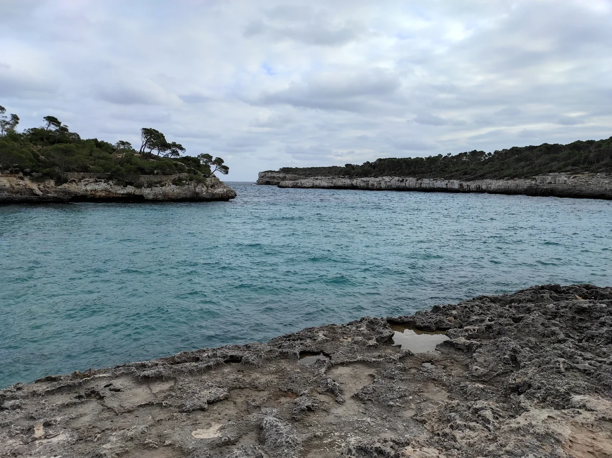
A sheltered turquoise cove between low rocky headlands with pines and scrub, seen over an uneven rock shelf.

Rocky shores and turquoise water in Parc Natural de Mondragó, photographed in February 2021.

Vista del parque natural de Mondragó.jpg — AlbertoDV / Wikimedia Commons / CC0 1.0 · Creative Commons

Walks and routes

1. Mirador de ses Fonts de n’Alis

640 m one way; official walking time 15 minutes, low difficulty. Start at the back of the ses Fonts de n’Alis car park beside the information centre. The route crosses former agricultural ground, descends through woodland and passes a viewpoint over the torrent and pond before reaching the beach. Allow 30–45 minutes downhill with stops, then time and energy for the return. Retracing it gives about 1.28 km altogether.

The entrance is a narrow opening in a wall. The leaflet describes a descent that steepens nearer the coast. It is not presented here as a wheelchair route; ask staff about a suitable alternative and the whole return journey.


1. Mirador de ses Fonts de n’Alis

2. Volta a sa Guàrdia d’en Garrot

940 m; official walking time 25 minutes, low difficulty. This circuit starts and finishes beside ses Fonts de n’Alis beach. Follow the signed woodland trail toward caló des Burgit and the coastal return. Pine and juniper woodland, rocky shore shapes and broad sea views make it a good second walk after the mirador. Allow 45–60 minutes for an unhurried circuit, plus the journey back to your arrival point.

This is a woodland-and-coast footpath, not an adapted promenade. Watch for irregular footing and keep children well away from the cliff edge. Do not assume the beach approach is suitable for every wheelchair or pushchair.

2. Volta a sa Guàrdia d’en Garrot

3. Punta de ses Gatoves

720 m; official walking time 25 minutes, low difficulty. On the s’Amarador side, the signed route follows coastal woodland toward caló d’en Perdiu and returns to the beach approach. Look for wind-shaped trees, the old lime kiln and rock textures visible from the path. Allow around 45 minutes with stops, in addition to reaching the route from the car park.

The general park leaflet says that part of this itinerary was adapted for reduced mobility. It does not establish the present condition, length or suitability of the whole circuit. Confirm the precise usable section, parking approach and facilities before travelling.

3. Punta de ses Gatoves

4. S’Amarador

1.1 km; the current official page gives 30 minutes and low difficulty. From the s’Amarador/Ca sa Muda parking approach, the walk explores woodland and farm boundaries before descending to the wetland and finishing near the beach access. A cone-roofed stone shelter and the pond provide two different kinds of pause. Allow 45–60 minutes plus the return to your starting point.

The leaflet explicitly includes a descent down steps to the torrent-side wetland. Its low difficulty rating does not mean step-free access. Woodland paths and the beach-side finish need a separate assessment for mobility aids and pushchairs.

4. S’Amarador

5. S’Hort d’en Metge

1.164 km; the current official page gives 60 minutes and low difficulty. Begin behind s’Amarador beach, on the side nearest the shore path toward ses Fonts de n’Alis. The circuit passes the public estates of s’Hort d’en Metge, Can Biga and Can Parra, with restored water-management features, scrub and cultivated plots. It returns toward the beach. Give it 60–90 minutes if you want to read panels and stop.

No complete step-free specification is supplied. The dune-side starting area, natural paths and approaches to old farm features are distinct from the adapted portion of route 3. Ask for current advice if you need a smooth surface, a wide passage or frequent seating.

5. S’Hort d’en Metge

A first visit from ses Fonts de n’Alis

Allow 1–2 hours. Ask at the information point, follow route 1 down through the woodland, stop at the viewpoint and watch the pond quietly. Have a short beach pause if conditions suit, then retrace the path uphill. This is the simplest way to keep the day manageable.

A longer morning with the coastal circuit

Allow 2–3 hours including breaks. Add route 2 from the beach area after route 1, take a picnic stop and leave enough time for the return to the car park or your bus. The two official routes total 1.58 km before that return; do not mistake this for the whole day’s walking.

A separate s’Amarador half-day

Use s’Amarador’s parking approach and choose route 3 for coastal woodland or route 4 for the pond and farm heritage. Add route 5 only if your group wants a longer outing. Beach time is optional, and the car-park approaches and return walks need time too.

Things to try

Make a three-habitat notebook

Choose one safe stop in woodland, one beside the wetland and one near the shore. Sketch a leaf shape, note the ground underfoot and listen for a minute. Compare what changes instead of collecting plants, shells or stones.

Try patient birdwatching

Bring binoculars and scan from the signed path without crowding the pond edge. Let the birds come into view. A quiet ten-minute stop is often more rewarding than repeatedly walking closer.

Read a working landscape

On the s’Amarador routes, look for walls, shelters and water-management features. Ask which job each structure performed, then use the interpretation panels to check the answer. Keep off the masonry and leave gateways clear.

Book a guided introduction

The park advertises advance-arranged guided visits and a separate activities programme. Call +34 971 17 60 65 to ask about a suitable visit, language, availability and any activity-specific charge. The regular guided service is listed as free; do not assume every event has the same terms.

Keep the coast for a better day

In strong wind, thunderstorms or rough seas, postpone exposed coast paths and swimming. A village break in Santanyí or Portopetro is a more sensible change of plan than forcing a five-route itinerary. Ask the information point for conditions before deciding whether any short walk is suitable.

Use the information stop for planning

If the centre is open, ask staff to help choose a later route and collect the official leaflets. Do not plan a full indoor museum visit: the published facility information describes an information centre, and the walking experience is outdoors.

Wildlife and habitats

Aleppo pine

Look at the outline of the pines above the path and how the canopy changes between sheltered woodland and the coast. Keep your observation simple: compare shapes without breaking off needles or cones.

Mastic

Notice the dense evergreen scrub beside the woodland paths. Mastic is one of the plants named in the official route leaflet; use a plant guide to compare leaves while leaving the shrub untouched.

Mallard

Mallards are fairly large ducks with broad bills. A male in breeding plumage has a glossy green head, while the female is mottled brown. Scan from the signed path and compare any ducks with the coots and moorhens.

Eurasian coot

Look for a dark waterbird with a white bill and white shield on its forehead. Watch whether it paddles on open water or dives for food. A few quiet minutes beside the pond can reveal more than a hurried glance.

Hoopoe

Look for a warm ochre bird with black-and-white wings, a long curved bill and a crest that can open like a fan. Hoopoes probe the ground for food; watch from the path without following one into a field.

Hermann’s tortoise

A tortoise crossing your path is a reason to stop and give it space. Watch quietly, keep dogs close and leave the animal where it is; do not move it into water or pick it up for a photograph.

Sea holly

Look from outside the dune ropes for the spiny leaves and, in season, bluish flower heads described in the route leaflet. The plants belong to a fragile sand habitat, so a distant view is the right one.

Sea daffodil

In summer, watch from the permitted path for white flowers among the dune vegetation. Avoid stepping onto apparently bare patches of sand: underground plant parts can be present even when nothing is flowering.

Common fig

Treat the fig trees in the farm landscape as part of its human story. Compare the shapes of cultivated plots and the surrounding scrub from public paths, without entering fields or picking fruit.

Rock samphire

On the coastal walk, notice how small plants occupy crevices above the sea. Use a guide or a photograph taken from safe ground to identify them; do not climb down the rocks or gather leaves.

Treat these as things to notice if they come into view, not a sighting checklist. Stay on the paths, keep back from ponds and nesting habitat, never feed or handle wildlife, and avoid playing bird calls. Enjoy the habitat even on a quiet day.

Stories and discoveries

A wetland behind the sand

The pond at ses Fonts de n’Alis occupies the final part of a torrent valley, with the beach acting as a barrier at the sea. Its extent changes with the seasons, so a dry-looking summer scene and a winter pool can be the same place.

Plants help keep a beach in place

At s’Amarador, dune plants are part of the structure of the habitat. Roots and underground stems help anchor loose sand. The ropes give vegetation space to recover; the best view is from the permitted path.

A coast with a much older story

The pale coastal rocks include material formed in ancient shallow seas. Rain, wind and waves have since shaped the shore. Look at textures and layers from the path; neither a fossil hunt nor a cliff-edge scramble is needed.

When to visit

Spring

Choose a gentle woodland walk and look for flowering scrub from the path. Take a layer for a windy coast and give the wetland a quiet stop. Confirm whether the seasonal bus has started before choosing a car-free outing.

Summer

Do the walking early and keep the plan short in heat. Carry enough water for the return, expect beach traffic and check parking charges. Dune flowers may be part of the scene, but stay behind the ropes to look at them.

Autumn and winter

After rain, the wetland can offer a different visit from the dry summer landscape. Keep walks flexible around wind, storms, wet steps and shorter daylight. Confirm transport and facilities separately; the park information point’s opening pattern does not make beach services year-round.

Getting there and practical advice

Ses Fonts de n’Alis information centre

The centre is beside the ses Fonts de n’Alis car park on the Portopetro–cala Mondragó road. The current park page lists 09:00–16:00 daily except some public holidays. Confirm your date on +34 971 17 65 02. This is the visitor starting point; the management office is elsewhere in Santanyí.

Parking, toilets and picnic stops

The park lists a public car park and recreation area at both ses Fonts de n’Alis and s’Amarador, with toilets, tables and benches in these visitor areas. Check which toilets are open and usable for your needs. Carry drinking water and food rather than relying on a tap or seasonal outlet.

Seasonal parking charges

Both main car parks are charged during the summer tourist season and listed as free outside it. The current official visitor page does not specify the exact charging calendar or tariff. Check signs and the current information before arrival; a place is not guaranteed.

Driving to the right side

Approaches are signed from Santanyí, s’Alqueria Blanca and the Cala Figuera road. Set navigation to the named public car park rather than a generic pin in the protected area. Ses Fonts de n’Alis suits the information centre and routes 1–2; s’Amarador suits routes 3–5. Use the official park page’s parking directions and obey barriers.

TIB bus 521

The seasonal route connects Cala d’Or with Cala Mondragó via Portopetro and Sa Barca Trencada. The government announced its 2026 restart for 24 April. Check TIB for the operating dates, departures, stop location, fares and return on your travel date; no year-round timetable is assumed here. The operator labels the route low-floor, but confirm boarding and the onward path if travelling with a mobility aid.

Walking between the beaches

The official tourism description identifies a paved shore link between s’Amarador and Cala Mondragó/ses Fonts de n’Alis. Use it only when conditions and signs permit. Check the complete route from your parking space or bus stop if you need a step-free visit; pavement alone does not establish that.

Choose a specific route, not a general label

Route 1 has a narrow wall opening and a descent; route 4 has steps. Route 2 includes natural woodland and coastal terrain. Ask the information centre to match the actual route, approach and return to your requirements rather than relying on the word easy.

Adapted section at Punta de ses Gatoves

The general park leaflet reports adaptation of part of route 3. Confirm where that section begins and ends, its surface and gradient, any temporary damage, and the usable toilets and parking approach. The published statement does not establish independent wheelchair access around all five routes.

Joëlette-assisted visit

Contact the information centre at least three weeks ahead on +34 971 17 65 02 to request a supported outing. The park lists the chair loan as free and dependent on available volunteers; agree the route, assistance, meeting point and timing before making travel plans. This is an arranged service, not equipment guaranteed to be waiting on arrival.

A walk and a beach visit need different checks

The signed trails, the information centre, seasonal parking, buses and beach services have separate arrangements. Check the service you need for the date you plan to go. A beach flag or lifeguard instruction governs swimming; it does not certify a coastal footpath, and an open path does not establish safe bathing.

Respect the protected landscape

Keep to the marked paths and respect private land. The park prohibits fires and drones, requires dogs on leads away from beaches, and asks visitors to take rubbish to bins in urban areas. The general leaflet also prohibits camping. Follow any temporary closure or staff instruction.

Sources and useful links

Wildlife you might spot

10

Each card links to a full Explore page with photos, traits, and fun facts.

Snap map for this place

Start with the big picture, then zoom in to explore individual wildlife observations around this place.

Loading map…

Good to know before you go

Check the park page, forecast and exact bus or driving arrangement before setting off. Save the official route leaflet and your return details offline.

Choose the correct car park

ses Fonts de n’Alis for the information centre and first two routes, or s’Amarador for the western paths. Use only authorised spaces and keep access roads clear.

Bring drinking water, sun protection and shoes with grip even if the main plan is the beach. Picnic tables are useful, but do not depend on seasonal food outlets for your supplies.

Budget for the return. The mirador’s 640 metres finishes at the beach; going back along the same path makes about 1.28 km in total and includes the uphill section.

Keep children close near cliff edges, steps, ponds and old structures. Watch from stable ground and leave caves, hollows and water tanks unexplored.

Stay outside roped dunes and wetland exclusion areas. Carry binoculars, leave plants and shells where they are, and keep the volume down.

Dogs must be on a lead and are not allowed on the beaches under the park’s published rules. Plan a route that avoids beach sections; do not assume every signed walk suits a dog outing.

Bring a bag for all your rubbish

the current park page says there are no bins in the park. Do not light fires, camp or fly a drone, and follow any temporary restriction.

Frequently asked questions

No. The beach commonly called Cala Mondragó is ses Fonts de n’Alis, also known as caló d’en Garrot. The natural park includes other coves, woodland, wetlands and inland farmland. This guide treats them as one destination, with ses Fonts de n’Alis as the first-visit base.
Try the 640-metre mirador walk if your group is comfortable with a narrow entrance and an uneven downhill path. Allow time to return uphill. For a longer woodland circuit from the beach area, sa Guàrdia d’en Garrot is 940 metres. Keep close supervision near the coast on either outing.
An established paved shoreline path connects ses Fonts de n’Alis and s’Amarador. Check it locally before using it, particularly in rough weather. It is a beach link, not proof that all the adjoining nature routes or sandy approaches are accessible.
Arrange a guided park visit in advance and register for scheduled activities. A Joëlette-assisted outing needs at least three weeks’ notice and available volunteers. For a self-guided visit, check current access notices and the parking or transport arrangements for your date.
The park lists paid parking in the summer tourist season and free use outside that season. Check the current charging dates, tariff and payment arrangements; the page does not give a verified current price. Parking is a separate service from choosing a nature walk.
Make swimming depend on the conditions and local instructions that day. Check the beach flags and whether lifeguards are on duty; a scenic sheltered-looking cove is not a safety guarantee. The ponds and conservation areas are for wildlife, so keep your beach activity to permitted areas.
TIB route 521 links Cala d’Or, Portopetro, Sa Barca Trencada and Cala Mondragó during its operating season. Confirm the timetable for your exact date, the stop location and the last return before travelling. Do not assume a winter service or a direct bus to the s’Amarador car park.
Hermann’s tortoise is documented in the park, where conservation releases have helped its populations. Enjoy the chance of an encounter without searching through vegetation. If one appears, give it space and leave it where it is.

Recent snaps at this place

Recent snaps will appear here as new observations are added.

View all ›

Take the discovery with you

Exploring Mondragó Natural Park?

Identify the wildlife you spot, learn as you go, and keep a collection of the adventure.

  1. 1Spot it
  2. 2Snap it
  3. 3Keep the discovery