Snappit logo
Snappit
Get App
Generic illustration, not a photograph of this venueIllustration
ParkAndalucía, Spain

Odiel Marshes Natural Area

The Odiel marshes are a landscape to watch changing.

About

The Odiel marshes are a landscape to watch changing. Water fills a creek, a strip of mud disappears, and birds that were feeding in one place move elsewhere. Where the Tinto and Odiel estuaries meet the Atlantic, salt-tolerant plants, tidal flats and salt pans create a surprisingly varied world within a wide, low horizon. Huelva and its working port remain part of the view.

For a first visit, make Calatilla your base. The Anastasio Senra visitor centre explains how tides shape the marsh and why migrating birds stop here. Its outdoor interpretation and nearby bird hide let you begin looking without trying to cover the whole protected area. Then choose Calatilla de Bacuta for a there-and-back view of creeks and contrasting saltworks, or Salinas de Bacuta for a short circuit through the traditional salt-pan landscape.

These public routes are a small, useful window onto a much larger protected area. The two nature reserves within it, Isla de Enmedio and Marisma de El Burro, have stricter access rules. You can appreciate the marshes from permitted paths and viewpoints; wandering along an inviting bank or landing on an island is not part of an ordinary visit. A guide is the right way to arrange access to other authorised sectors. Wondering what that bird or insect is? Find out on your visit using the Snappit nature app.

Salt, fishing and navigation have connected people with this estuary for centuries. The traditional Bacuta salt pans make that history visible in a network of pools and regulating banks; neighbouring industrial saltworks show a different scale of production. The visitor centre also interprets the area’s archaeological and maritime past. The marshes received legal protection in 1984. The historical designation included the words ‘de Interés Nacional’, but today’s protected-area category is Paraje Natural. Isla de Enmedio and Marisma de El Burro are nature reserves within that wider area. The 2025 management plan brings their conservation and public-use rules together, and the estuary also forms part of the Natura 2000 network.

What to do here

Begin with the visitor-centre exhibition, watch quietly from the Calatilla hide, and take one of the two nearby signed salt-marsh walks. Compare a tidal creek with a managed salt pan, notice the different plant bands, and use binoculars to follow feeding behaviour rather than chasing a long species list.

Seasonal info

Spring is a sensitive breeding season: keep well back and never seek out nests. Summer paths can be very hot and have no shade, so choose an early, short outing with water and sun protection. Autumn and winter can be excellent for watching birds, but wind, rain and storm-driven high water may change the plan.

Accessibility

The official directory lists physical, visual and hearing accessibility at Anastasio Senra, and physical accessibility for Salinas de Bacuta and the Calatilla recreation area. That does not describe every path, viewing opening or toilet. Ask staff which surfaces and sections suit your needs; Calatilla de Bacuta has no equivalent accessibility listing, and the hide is reached over a wooden walkway.

Don't miss

1

Anastasio Senra

a clear introduction to tides, marsh habitats and the people who work beside them.

2

Calatilla de Bacuta

an open view of tidal creeks and the contrast between traditional and industrial saltworks.

3

Salinas de Bacuta

a short circuit showing how banks, sluices and evaporation pools shape the landscape.

4

Waterbirds at their own pace

flamingos, spoonbills and smaller waders are reasons to stop rather than hurry.

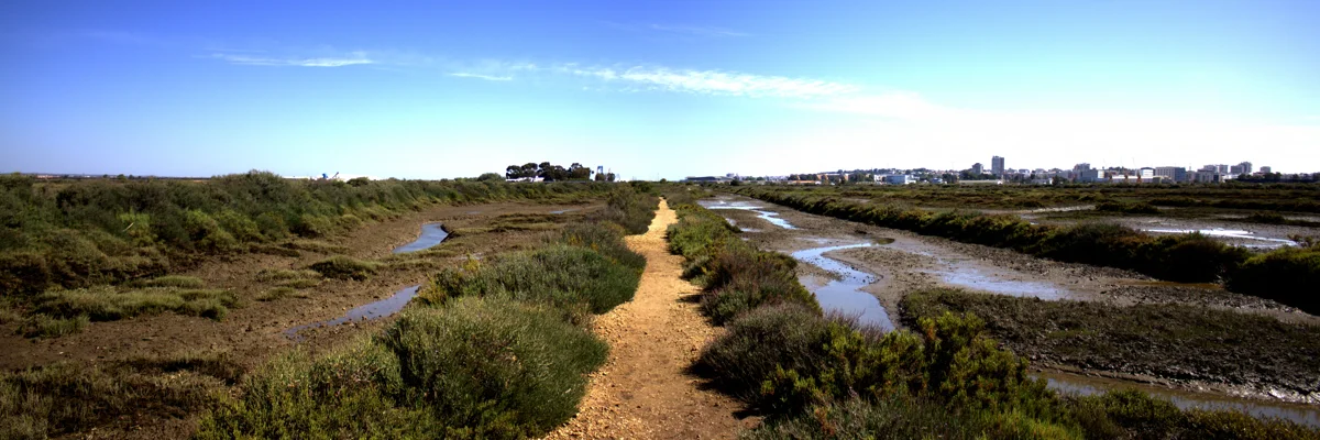
Narrow tidal channels cut through low marsh vegetation, beside an earth strip leading toward a distant urban skyline.

A panoramic view of Marismas del Odiel in May 2015, with tidal channels and low marsh vegetation.

Marismas del Odiel 01.jpg — Felipe Moreno Baquero / Wikimedia Commons / CC BY-SA 3.0 Spain · Creative Commons 1 · Creative Commons 2

Walks and routes

Calatilla de Bacuta: the creek-and-saltworks walk

The current official listing gives 820 metres one way, a linear route and 30 minutes of walking. Return by the same path, making about 1.64 km before any extra wandering; allow 60–90 minutes with birdwatching stops. The start is just beyond Anastasio Senra, before the bridge over Caño de Calatilla. Follow the signed saltworks bank to its public end and return, comparing the traditional Bacuta landscape with the industrial salt pans. The older leaflet rounds the distance to 0.8 km and gives 20 minutes one way; use the more generous allowance for a relaxed visit.

The official difficulty is low, but this exposed bank route has no shade and is not listed with the physical-accessibility symbol shown for Salinas de Bacuta. Ask about today’s surface, gates and edge conditions if using wheels or needing a particularly even path.


Calatilla de Bacuta: the creek-and-saltworks walk

Salinas de Bacuta: traditional salt-pan circuit

The official listing describes a 1.68 km circular trail, with a walking time of 30 minutes and low difficulty; the leaflet rounds it to 1.7 km. Allow 60–90 minutes to look at the pools and birds. The signed start is immediately beyond the bridge onto Isla de Bacuta, on the right when approaching from Anastasio Senra. Follow the route along the dividing banks, noticing the relationship between storage, evaporation and crystallisation pools. Ask whether the Centro de la Sal interpretation building and the route’s hide are open before counting on them as stops.

The official directory marks this path for physical accessibility, while the leaflet describes a track without shade. Confirm surface condition, widths, slopes and the usable circuit with staff. There is no dedicated parking at the trail start according to the leaflet; arrange a suitable approach rather than assuming a step-free link from any roadside space.

Salinas de Bacuta: traditional salt-pan circuit

Two to three hours: a gentle first look

Start with the exhibition, if open, then settle briefly at the Calatilla hide. Choose one walk: Calatilla de Bacuta for a simple out-and-back with broad creek views, or Salinas de Bacuta for the salt-pan circuit. Leave time for the return and a drink. If the centre is closed, use the official signs and current access notices, and shorten the plan if you are unsure.

Half a day: both sides of the salt story

Visit the centre early in its opening period, walk Calatilla de Bacuta out and back, and take a break at the Calatilla complex. If the weather, access and energy levels still suit, add the Salinas de Bacuta circuit. The two trails together total about 3.32 km, excluding links from parking and movement around the centre. Ask staff about the safest connection across the road and bridge; do not improvise a shortcut along a bank.

A tailored visit with a guide

For a deeper birdwatching or heritage day, arrange an authorised outing in advance rather than adding restricted trails to a self-guided itinerary. Confirm what is included and where it goes. The centre’s wider programme may offer occasional environmental activities, but each needs its own date and booking check.

Things to try

Learn the marsh before walking

Spend 30–45 minutes with Anastasio Senra’s displays if it is open. Look for the explanation of tides, food webs and the meeting of wetland conservation with a busy urban and industrial estuary. The outdoor interpretation continues the story with native plants and lagoons; ask which parts are open that day.

Let the tide provide the experiment

Choose a safe point on a public path and note the waterline beside a creek. Return later and compare the exposed mud, plant edges and feeding activity. Do not cross a creek or leave the bank to make the comparison; the changing view is the activity.

Compare two ways of making salt

At Bacuta, look at the small pools and banks of the traditional saltworks, then compare their scale with the industrial works visible from Calatilla de Bacuta. Use signs and public paths to understand the water’s route from one pool to the next. Working salt pans and service tracks are not open invitations to explore.

Try a quiet family spotting game

From one safe stopping place, find three different bill shapes, a bird that walks and a bird that swims, or three shades of marsh vegetation. Keep the challenge about observation rather than getting close. Short, patient stops work better than trying to finish both trails with tired children.

Arrange a guided visit beyond the first-visit area

Onubaland advertises guided visits, and the official visitor page describes pre-arranged boat and land outings. Ask Anastasio Senra about dates, language, cost, minimum group size, permissions and accessible transport. The 2025 plan reserves much of the wider area for visits through authorised providers; do not assume an old train or boat description is a current timetable.

Make photographs from the path

Use a long lens or binoculars for distant birds and a wider view for the banks, water and sky. Ordinary visitor photography should remain within permitted public areas. Ask the park before planning lighting, fixed hides or a production using additional equipment, which can need authorisation.

Spend longer with the exhibition

If the centre is open and safe to reach, let its displays explain what is happening outside. Keep any hide visit short and ask about walkway condition. The exhibition is the useful indoor option; the kiosk or an unstaffed trail building should not be treated as a guaranteed shelter.

Postpone the exposed paths

Heavy rain, strong wind, thunderstorms or water over the path are reasons to turn back or choose another day. Do not step around a flooded section onto mud or a salt-pan bank. A tide forecast helps planning but does not guarantee safe conditions when weather affects water levels.

Wildlife and habitats

Greater flamingo

Long pink legs, a long neck and a thick bill bent downward make adults distinctive; young birds can look much greyer. Watch a distant feeding group through binoculars and notice the heads moving below the surface. Scan shallow salt-pan water from the public paths.

Eurasian spoonbill

Look for a white wader sweeping a flattened, spoon-ended bill from side to side through shallow water. A sleeping bird may hide the bill, so wait for it to lift its head. Use permitted viewpoints over open shallows and leave breeding birds undisturbed.

Black-winged stilt

Exceptionally long red-pink legs, a slim straight bill and a black-and-white body are the clues. Watch how a stilt takes small prey from the water’s surface and shallow margins. The Bacuta trail sources describe the species in the marsh and salt-pan landscape.

Grey heron

Look for a large grey-backed bird standing almost motionless at the water’s edge, with a long pointed bill ready to strike. In flight, herons usually fold the neck back, unlike spoonbills. The Calatilla and Bacuta viewing areas offer places to scan without approaching the shore.

Osprey

Scan the open water and sky for a fish-hunting raptor with pale underparts and a dark eye stripe. A bird may pause above the water before diving. Enjoy any encounter from the public route; do not look for nests or follow a bird to a perch.

Northern shoveler

The broad, shovel-shaped bill is more reliable than colour alone. A well-marked male has a dark green head, white breast and chestnut sides; females are mottled brown. In the cooler months, scan groups of ducks on sheltered water and compare bill shapes.

Glassworts

Look from the path for low, fleshy, jointed-looking salt-marsh plants, with some patches turning reddish in autumn. The official flora account includes Salicornia ramosissima. This is a genus-level introduction: several salt-tolerant plants can look alike, so avoid naming an exact species from a quick glance. Do not pick or taste plants.

These are wild animals: species, numbers and viewing distance change with the season, tide and conditions. Stay quiet on permitted paths and in hides, give roosting birds space, and never approach nests, feed wildlife or use call playback. A bird that stops feeding to watch you is a reason to move back. Leave all plants and small creatures where they are.

Stories and discoveries

The marsh has a daily rhythm

These are tidal marshes. Water movement and sediment create changing edges and channels, while differences in height and salinity help determine where plants can grow. The low, open landscape is full of small ecological boundaries.

Salt pans can hold useful habitat

Traditional salt production changed the marsh, yet its pools and banks now also provide feeding and resting habitat for waterbirds. Look at the relationship between built water-control structures and the birds using them, rather than imagining a landscape untouched by people.

An estuary beside a working city

The visitor centre explains why managing this wetland means dealing with a neighbouring urban area, port and productive activities. The industrial backdrop is part of the place’s conservation story, not something the guide has cropped out.

A plant’s position tells a story

Salt-tolerant vegetation is arranged partly by how often the ground floods and how salty it becomes. Compare low patches beside a creek with higher banks without leaving the path; a change of only a little height can change the plant community.

When to visit

Spring

Plan a quiet, unhurried visit as birds breed and migration continues. Stay on public routes, keep dogs close and avoid any attempt to find nests. Enjoy behaviour you can see from a distance and follow temporary restrictions.

Summer

Start early and keep the walk short. The two Bacuta routes have no shade, and the visitor centre’s summer calendar differs from its autumn schedule. Carry water, use sun protection and consider an exhibition-focused visit when the forecast is too hot for the banks.

Autumn

Watch the marsh change with migration, cooler weather and reddish patches of salt-tolerant vegetation. The timing varies, so choose a comfortable day rather than expecting a fixed peak. Check wind and rain before committing to both paths.

Winter

Allow time for ducks and other wintering waterbirds, and bring a warm windproof layer. A bright, calm day can be rewarding, but exposed paths feel very different in driving rain. Check the forecast and use the centre only within its confirmed winter opening hours.

Getting there and practical advice

Anastasio Senra visitor centre

The Calatilla base has an indoor exhibition and outdoor interpretation about the estuary. The official contact is +34 682 654 491 / +34 671 564 186, [email protected]. Its address is Carretera del Dique Juan Carlos I, km 3, Huelva. Contact staff for today’s access, activities and practical arrangements.

Calatilla bird hide

The official listing places the hide within the Calatilla complex, near the visitor centre and offices, with nearby parking and a wooden approach walkway. It overlooks lagoons. Ask staff whether it is open and whether its approach and viewing openings suit you; it is a viewing shelter, not permission to enter surrounding habitat.

Recreation area and kiosk

Calatilla’s small recreation area complements the centre. A kiosk-bar is listed, with a separate 2026 calendar linked from the centre page. Confirm whether refreshments are available when you visit and bring water and a snack regardless. Do not substitute the kiosk calendar for exhibition hours.

Centro de la Sal and other trail structures

The Salinas de Bacuta listing describes a salt-interpretation building, while the centre listing mentions the route’s hide and viewpoints. Ask which are currently open. A building shown in a leaflet or a facility description is not a promise of staffed access during your walk.

Toilets, seating and water

Ask the visitor centre about toilet opening, an accessible toilet if needed, seating and drinking-water provision. Do not plan on these services along the exposed salt-pan paths. Keep enough water for the full outing and take your litter away.

By road to Calatilla

From the A-497 Huelva–Punta Umbría route, follow the signed turn for Marismas del Odiel and Carretera del Dique Juan Carlos I. The visitor centre is beside the Calatilla complex at km 3. Use the exact facility name for navigation and park in a designated area; the full protected area has no single entrance that serves every sector.

Parking and the two trail starts

Calatilla has nearby parking. The Calatilla de Bacuta leaflet describes parking near its start, but Salinas de Bacuta has no dedicated trailhead car park. Ask staff which legal parking and pedestrian approach are best for your route. Never leave a car on a salt-pan bank or at a gate.

Without a car

Confirm a return taxi, transfer or organised visit to Anastasio Senra. Older leaflets mention regional buses, but they do not establish a current service stopping at the visitor centre or trailheads. Check the exact stop and last return before relying on public transport; a bus to Huelva or Punta Umbría is not automatically a connection to Calatilla.

Cycling

Use designated cycle routes and current signs. The management plan does not allow cycling on pedestrian-only paths or across the marsh. Ask where you can leave a bicycle before using the birdwatching walks; do not treat every flat saltworks track as a cycle route.

Start with the centre

Anastasio Senra carries physical, visual and hearing-accessibility symbols in the official directory. Ask about the step-free arrival, accessible toilets, current interpretation support and usable outdoor paths. State the help or dimensions you need rather than relying on a general accessible label.

Choose a path deliberately

Salinas de Bacuta is marked for physical accessibility, but it is an exposed salt-pan track. Confirm the current surface and full circuit, especially after rain. Calatilla de Bacuta’s low walking difficulty does not establish wheelchair suitability; ask before choosing it.

Check the hide and the connecting route

The Calatilla hide uses a wooden walkway, and the recreation area has a physical-accessibility listing. Neither fact establishes the width or gradient of every link from parking or the height of the hide’s openings. Arrange the approach with staff and be ready to choose a shorter visit.

Heat, wind and sensory comfort

The open banks can be tiring in hot sun or strong wind even though the walks are short. A shorter centre-and-hide visit may suit better, provided those facilities are open. Bring protection from glare and arrange quiet breaks rather than committing to a complete circuit.

Visitor-centre hours: check the exact date

Checked 17 October 2026: the official calendar lists Anastasio Senra on 17–18 October from 09:00 to 14:00, closed on Monday 19 October, and open Tuesday–Friday 20–23 October from 10:00 to 14:00 and 16:00 to 18:00. From 27 October the weekday pattern shown changes to 09:00–15:00, with weekends generally 09:00–14:00 and Mondays generally closed. Holidays have exceptions. Use the date-specific calendar on the official page and confirm before travelling; these times apply to the centre, not every path or the kiosk.

Current route notice

The 29 July 2026 official notice confirms that Calatilla de Bacuta’s works finished and the whole trail reopened. It supersedes the June works closure. Check the park and route pages again before setting out, and obey any newer local notice.

Independent walking has limits

The 2025 management plan allows individual visitors at the centre, the Calatilla recreation area and hide, and the signed Calatilla de Bacuta and Salinas de Bacuta trails. Much of the rest of the protected area is visited through authorised providers. El Acebuchal explicitly requires authorisation; do not add it or another restricted track to your day simply because it appears on a map.

Reserve islands and boat outings

Isla de Enmedio and Marisma de El Burro require specific access authorisation. Ordinary boat outings must stay within permitted navigation arrangements and are not landing trips to these reserves. Book through an appropriate authorised operator and follow the skipper’s route and restrictions.

Prices and reservations

Ask the centre about any admission charge and the services included in your visit. For guided outings, confirm the full price, booking terms, departure time, transport and weather cancellation policy directly before booking.

Tides and weather

Consult the official tide and weather resources, then ask staff about the day’s public paths and viewpoints. Exposed mud is habitat, not a shortcut. Never wade across a channel, cross a barrier or continue onto an overtopped bank; weather can alter water levels beyond a simple astronomical tide prediction.

Sources and useful links

Wildlife you might spot

7

Each card links to a full Explore page with photos, traits, and fun facts.

Snap map for this place

Start with the big picture, then zoom in to explore individual wildlife observations around this place.

Loading map…

Good to know before you go

Check the visitor-centre calendar and the park’s latest notices before travelling; the centre, kiosk and outdoor facilities do not necessarily share opening hours.

Bring binoculars, drinking water, a hat and a windproof layer. Both salt-pan walks are exposed and lack shade.

Stay on the signed public paths. Dry-looking mud, salt-pan banks and reserve islands are not alternative walking routes.

Give Calatilla de Bacuta enough time for the return: its listed 820 metres is one way, not the whole outing.

Watch quietly, keep a generous distance from resting birds and never use food or playback to bring them closer.

Use designated parking near the Calatilla complex; do not park on a bank, block a gate or stop on a bridge for a photograph.

Arrange restricted-sector tours ahead of time, confirming the exact route, price, meeting point and accessibility.

Keep pets identified and on a lead, and ask about facility-specific restrictions. If birds become alert or move away, increase your distance.

Frequently asked questions

Its official category is Paraje Natural. The historical phrase ‘de Interés Nacional’ can be confusing, but it does not make Marismas del Odiel a national park. The two nature reserves inside it have their own stricter protections.
Yes, in the public-use places allowed by the management plan, including Anastasio Senra, the Calatilla recreation area and hide, and the signed Calatilla de Bacuta and Salinas de Bacuta trails. Other sectors may require an authorised company or organisation. Follow the current signs and ask at the centre before extending your walk.
Confirm any centre or trail admission charge directly with Anastasio Senra before travelling. Guided activities have their own prices and booking conditions; a free event advertised for a particular date is not a daily free-tour offer.
Low water exposes mud where waders can feed, while higher water changes the available feeding and resting places. The salt pans are managed water bodies and do not behave exactly like the creeks. Ask staff which permitted viewpoint suits the day’s tide; never step onto the mud to get closer.
Access to either reserve requires specific authorisation. Treat them as protected habitat to appreciate from permitted viewpoints, not destinations to enter on an ordinary walk or boat trip. Do not land on their shores.
Both are well documented here, but numbers and visibility vary with season, water levels and disturbance. Bring binoculars and enjoy the wider marsh landscape if the birds are distant. Staff can suggest a suitable public viewing point without approaching breeding areas.
Start by discussing the visitor centre and the Salinas de Bacuta path with staff. Official accessibility symbols do not provide current gradients, gate widths or surface condition. Ask about parking, toilets, viewing openings and the wooden approach to the hide before choosing your route.
The official park information describes pre-arranged guided boat and land visits, and Onubaland advertises guided outings. Ask the centre what is actually running on your date, how permissions are handled and whether the proposed vehicle or boat suits your group. Do not assume a scheduled train or boat departs every day.
The management plan requires pets to be on a lead and identified. Ask about restrictions at the centre, hides and any guided activity, and keep well away from feeding or resting birds.

Recent snaps at this place

Recent snaps will appear here as new observations are added.

View all ›

Take the discovery with you

Exploring Odiel Marshes Natural Area?

Identify the wildlife you spot, learn as you go, and keep a collection of the adventure.

  1. 1Spot it
  2. 2Snap it
  3. 3Keep the discovery