
Snappit logo
Snappit
Get App
Generic illustration, not a photograph of this venueIllustration
ParkComunidad de Madrid / Castilla y León, Spain

Sierra de Guadarrama National Park

Guadarrama stretches across the mountains between Madrid and Segovia.

About

Guadarrama stretches across the mountains between Madrid and Segovia. Its appeal changes with altitude: leafy valley woods give way to tall pines, then open slopes and high ground. You can begin to understand those changes on a gentle visit, without turning a family day into a summit expedition.

Make Boca del Asno your starting point. This visitor gateway lies in the protected Valsaín landscape; the centre, botanical trail and nearby river woods should not be mistaken for a tour of the national park’s strict interior. Start with the exhibitions, then explore the short Senda de los ecosistemas if it is open. Its planted examples bring different mountain habitats together in one small space.

The Eresma adds the sound and movement of water to the pines and granite. Enjoy it from an open, safe path, but check before committing to a river circuit: several Valsaín bridges were still listed as unavailable when checked on 16 October 2026. For a separate outing inside the national park, prepared walkers can consider the route from Los Cotos to the Zabala area in Peñalara. Give that higher, steeper walk its own weather and access plan. Be ready to snap and learn! Get the Snappit app to identify any nature species you find here.

The pines of Valsaín belong to a long-used landscape. Timber, grazing and local woodland trades form part of its story, and forest management still balances these uses with nature conservation. A walk here is also a chance to think about how people care for a working forest. Along the Eresma, Carlos III’s fishing path, the Pesquerías Reales, was built between 1767 and 1769. Its worked granite brings royal history into the woodland. The national park itself was declared by Law 7/2013 of 25 June, joining a much longer history of interest in protecting these mountains.

What to do here

Begin indoors, choose a habitat to look for outside, then make the botanical trail your main walk. Leave time to sit under the pines and notice the differences between shade, sunlight and damp ground. Add the Blue itinerary only after staff confirm the whole circuit is usable.

Seasonal info

Spring rain and snowmelt can raise the river; summer brings heat, fire precautions and busy parking. Autumn leaves can hide slippery ground. In winter, ice and snow may affect both roads and paths, and the high-mountain route requires a very different level of experience.

Accessibility

The Boca del Asno building is described by the operator as universally accessible, and the short Senda de los ecosistemas is described as accessible. Check the garden gate, today’s surface and the route from your arrival point with staff. The rocky riverside circuit and the climb to Zabala have different demands.

Don't miss

1

A compact introduction to mountain habitats at Boca del Asno

2

Tall Valsaín pines and the granite-lined Eresma

3

A botanical trail short enough to explore slowly

4

A separate Peñalara walk for views of a glacial mountain hollow

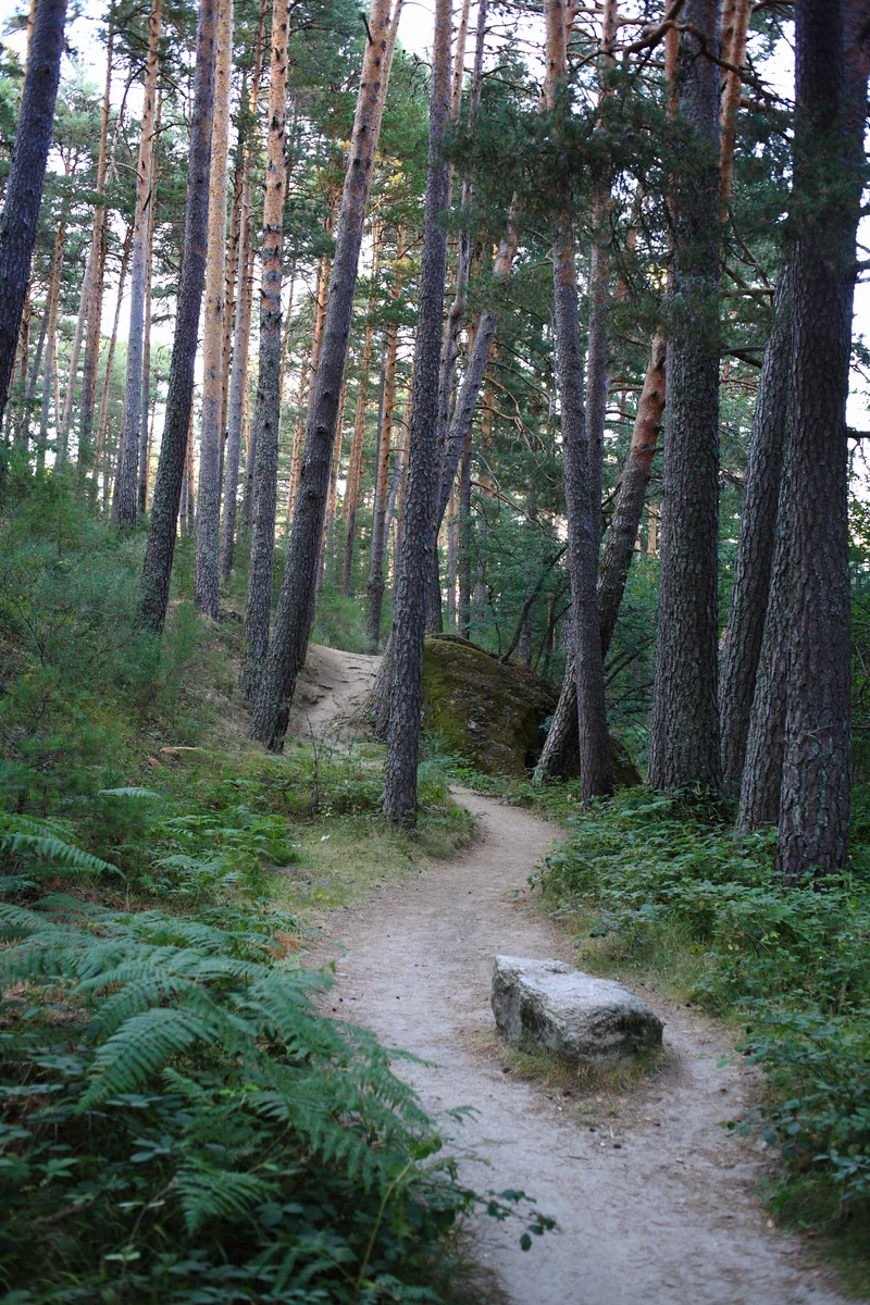
A narrow earth path winds between tall pine trunks, ferns and rocks.

A woodland path at Boca del Asno, photographed in August 2013. This Valsaín gateway sits within the wider protected Guadarrama landscape.

Boca del Asno - Segovia - Spain.jpg — Javier Pérez Montes / Wikimedia Commons / CC BY-SA 4.0 · Creative Commons

Walks and routes

Senda de los ecosistemas: the short botanical walk

Start opposite the Boca del Asno visitor centre and follow the signed garden path. Planted habitat displays move from mountain summits through pine and riverside woodland to oak country. The official page rounds the length to 0.3 km and gives 5 minutes of walking; allow 20–40 minutes to stop and read.

The park describes this path as accessible, with a gentle slope. Ask about the gate, current surface and any help needed before setting out with a wheelchair or pushchair.


Senda de los ecosistemas: the short botanical walk

Itinerario azul de Valsaín: conditional river circuit

The signed Blue itinerary normally follows pine woodland to Puente de Navalacarreta, crosses the Eresma and returns along the Pesquerías Reales. The official figures are 2.1 km, 80 m of ascent and 40 minutes walking. Allow 1–1½ hours with stops only if staff confirm the full circuit is usable.

This is an uneven woodland and riverside path with granite and bridges. It is not described here as a wheelchair route; supervise children closely near water.

Itinerario azul de Valsaín: conditional river circuit

Los Cotos to the Zabala area: a separate national-park walk

Start at the Peñalara visitor centre at Los Cotos and follow the official Zona del Zabala route uphill through pines towards the glacial cirque. Return the same way. Official figures are 4.7 km total, 279 m ascent and 1 hour 45 minutes walking; allow 2–3 hours with stops. This is an alternative half-day for prepared walkers, rather than an extra stop on the Boca del Asno visit.

Expect sustained climbing, steeper sections and mountain paths. The accessible visitor centre does not make the route wheelchair-accessible.

Los Cotos to the Zabala area: a separate national-park walk

A relaxed Boca del Asno visit

Start with the centre and ask what is open. Take the botanical walk slowly, then settle at an available picnic table or bench. Allow 2–3 hours, with no need to add a longer walk to make the trip worthwhile.

If you want more walking

After the centre and botanical trail, ask specifically about the complete Blue itinerary. If it is usable and everyone has energy, allow another 1–1½ hours. Otherwise keep the day short; a closed bridge is a good reason to change the plan.

A separate Peñalara half-day

Go directly to Los Cotos after checking its access and weather conditions. Ask at the Peñalara centre, walk the official Zabala route if suitable, and return the same way. Allow about 2–3 hours on foot plus generous time for arrival and breaks.

Things to try

Make a tiny habitat notebook

Choose three textures or shapes you can see from the path: a trunk, a leaf and a stone. Sketch or photograph them, then use the centre’s displays to work out how each fits its habitat.

Take a quiet listening break

Stop somewhere wide enough for others to pass. Compare the sound of the river with the quieter woodland. A minute without conversation often reveals more than another kilometre of walking.

Join a guided outing

The centre advertises free guided activities with limited places and advance booking. Check the current programme for an outing that fits your group; a listed activity is not a promise of available places.

A shorter, mostly indoor visit

If the centre is open and travel is safe, spend longer with the exhibitions and save the walk for another day. In strong wind, flooding or hazardous road conditions, postpone rather than treating woodland or a riverside path as shelter.

Wildlife and habitats

Scots pine

Compare the pines around you with the labelled examples near the centre. Look at trunk shape, bark and needles without taking anything away.

Great spotted woodpecker

Pause quietly and listen among the trees. Let a sound draw your attention rather than playing calls or approaching a nest.

Griffon vulture

From an open, permitted part of the path, look up for large soaring birds. Binoculars help, but stop walking before using them.

Cinereous vulture

This is one of the region’s important forest birds. Watch distant birds from public paths; avoid nest sites and do not share sensitive locations.

White-throated dipper

If an open path safely overlooks flowing water, pause and watch the river. Stay well back from its edge and never move stones or enter the stream.

Pyrenean oak

Look for labelled oak examples along the botanical walk, then compare the broad leaves with pine needles. The garden is a planted display; wild Pyrenean oak also belongs to Valsaín’s lower woods.

These are species to learn about, not a checklist you need to complete. Wild animals decide whether to appear. Stay on permitted paths, keep quiet, leave plants in place and give any animal plenty of room.

Stories and discoveries

A forest with a working history

Valsaín is managed for several purposes together, including nature conservation, timber, grazing and visitors. The tall trees are part of a living landscape with local livelihoods attached to it.

A king’s fishing path

The Pesquerías Reales was built for Carlos III in 1767–1769. Its dressed granite is a reminder that a riverside path can be both wildlife habitat and historic infrastructure.

When to visit

Spring

Allow for wet paths and a stronger river after rain or snowmelt. Keep the botanical visit flexible and ask about bridges before adding riverside walking.

Summer

Start early, carry water and plan a flame-free picnic. Check parking controls and fire information. For higher walking, avoid exposed ground if thunderstorms threaten.

Autumn

Enjoy the contrast between broadleaved trees and the pines, but watch slippery leaves and shortening daylight. After heavy rain, recheck both roads and riverside access.

Winter

Make the indoor centre the focus only if roads and access are safe and opening is confirmed. Snow and ice can transform even familiar paths; postpone the high route unless properly equipped and experienced.

Getting there and practical advice

Boca del Asno visitor centre

Free exhibitions and route advice. At the October 2026 check, non-summer hours were 09:30–14:00 and 14:30–16:00. The published annual closure dates are 1 and 23 January, 25 August and 25 December. Confirm before travelling on +34 921 120 013; summer hours differ.

Picnic and rest

The recreation area has tables, benches and a children’s play area. Bring your own food and drinking water. Check with staff about toilets and their opening, especially if you need an adapted facility.

Botanical garden

The short interpretive trail is beside the centre, but its gate has independent hours. Ask before building the day around it.

Peñalara facilities for the separate mountain visit

The Los Cotos visitor centre provides route advice and is described as accessible; a separate services building has a public adapted toilet. Confirm access to the specific facilities you need before travelling.

By road to Boca del Asno

Use the signed Boca del Asno entrance from the CL-601 between La Granja and Puerto de Navacerrada. Summer weekend and holiday parking is capacity-controlled. Check the current arrangements, park only where permitted and choose another plan if full.

By bus from Segovia

The centre lists Linecar M3 to Boca del Asno on Saturdays. Check the operator’s current timetable in both directions. M8 serves Valsaín’s Frontón stop, about 4 km away on foot; do not rely on the riverside approach without confirmation that every crossing is usable.

For the separate Los Cotos visit

Los Cotos has its own parking limits and public-transport arrangements. Check the Peñalara centre’s travel advice and the relevant operator before setting out, especially for winter roads or changed rail services.

Centre and arrival

Ask the Boca del Asno team about the journey from parking or the bus stop to the building, toilets and any assistance needed. The operator’s universal-access description applies to the building.

Botanical trail

This is the specific outdoor path described as accessible by the park. Its short length makes a slow visit practical, but check present surface conditions, the garden gate and your own equipment requirements.

Other walks

Neither the Blue itinerary nor the Zabala climb is presented as an adapted route. Choose the short visit if uneven surfaces, bridges or sustained ascent would make the outing uncomfortable.

Travelling with a larger group

For the Boca del Asno building, groups of 15 or more book at least 24 hours ahead. Hiking groups of more than 25 around Boca del Asno and the Eresma need the Castilla y León responsible-declaration procedure. In Peñalara, groups of 15 or more need separate authorization and an appointment. Ask the relevant centre before arranging the visit.

Sources and useful links

Wildlife you might spot

5

Each card links to a full Explore page with photos, traits, and fun facts.

Snap map for this place

Start with the big picture, then zoom in to explore individual wildlife observations around this place.

Loading map…

Good to know before you go

Check the park’s current notices and AEMET mountain forecast before leaving. Ask the Boca del Asno team which paths and bridges are usable that day.

Bring drinking water, a snack, grippy footwear and a waterproof layer. Shade does not remove the need for sun protection or extra water in summer.

If parking is full, follow staff directions and choose another plan. Do not leave the car on the roadside or walk along the traffic lane to reach the centre.

Keep children close beside water and granite edges. Never step around a closed bridge, ford the river or follow an unofficial detour.

Leave the river and pools undisturbed

bathing and walking through the water are prohibited. Take photographs from the path.

Keep dogs on a lead. Ordinary pets cannot enter the visitor-centre building; ask ahead about assistance-dog access.

Picnic without flames

barbecues and camping stoves are prohibited. Take all rubbish away and do not feed wildlife.

For Los Cotos, check the separate parking and visitor limits before travelling. Turn back if ice, snow, poor visibility or storms make the walk unsuitable.

Frequently asked questions

Treat it as the park’s Valsaín visitor gateway in the wider protected landscape. This guide distinguishes that short outing from the separate Los Cotos–Zabala route in the national park’s Peñalara sector.
Only after checking the current bridge situation. The official route describes a circuit, but the park’s notices list several unavailable Valsaín bridges. Ask staff whether the complete Blue route is passable; do not assume an old map proves that it is.
Individual visits are free and do not need a reservation. Groups of 15 or more must book at least 24 hours ahead. Outdoor guided activities have separate bookings.
No. The centre’s current guidance prohibits bathing or passing through the water. Enjoy the river from the bank without leaving the permitted paths.
The centre lists Linecar M3 to the Boca del Asno stop on Saturdays. Check the current timetable and return journey before committing. The M8 stop in Valsaín leaves a substantial onward walk, which is not a simple fallback while river crossings are affected.
The Zabala route includes 279 m of ascent and steeper ground. Choose it only when everyone is comfortable with that effort and conditions are suitable. The botanical trail at Boca del Asno is the gentler option.

Recent snaps at this place

Recent snaps will appear here as new observations are added.

View all ›

Take the discovery with you

Exploring Sierra de Guadarrama National Park?

Identify the wildlife you spot, learn as you go, and keep a collection of the adventure.

  1. 1Spot it
  2. 2Snap it
  3. 3Keep the discovery








