
Snappit logo
Snappit
Get App
Generic illustration, not a photograph of this venueIllustration
ParkComunidad de Madrid, Spain

Middle Guadarrama River Regional Park

Start small here.

About

Start small here. The regional park stretches across much of western Madrid, but the Puente del Retamar recreation area in Las Rozas gives you a manageable place to begin. Come for the short botanical trail, a look at the old bridge and enough unhurried time to notice what is moving in the trees or on the water.

The B3 Senda Botánica Puente del Retamar is listed as a 1 km, low-difficulty route. That makes it a useful choice for a gentle nature outing, provided the ground and river conditions suit your group. Read the interpretation as you go, compare the trees beside the water and use the recreation area for a rest rather than treating the walk as something to finish quickly.

The wider river woods include willows, poplars and ash, while drier parts of the park hold Mediterranean woodland and farmland. The trees along the water help hold the banks together and provide cover for wildlife. On the botanical walk, notice how much a change in shade, leaf shape or ground moisture can reveal before you have identified a single species.

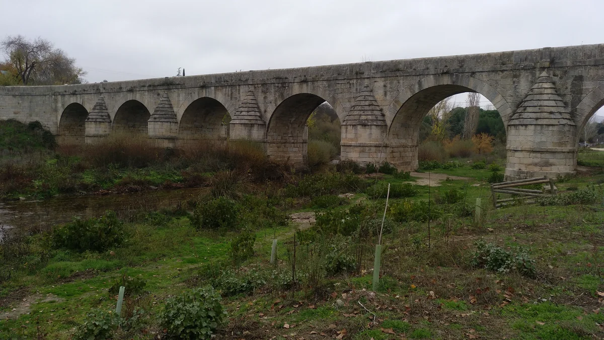
The bridge gives the outing a second focus. Its seven granite arches belonged to the old road between Madrid and El Escorial. Look at the shape of the stone piers and how the structure sits across the river, keeping to the open public approach. You can enjoy the bridge without clambering onto masonry or going down to the water’s edge.

If everyone wants a longer walk, the separately described LR-06 route links Molino de la Hoz reservoir with Retamar. It is a different route from B3, with stream crossings and a road underpass along the way. Check its condition first and plan how you will return. There is plenty to enjoy at Retamar without adding that extra section. Wondering what that bird or insect is? Find out on your visit using the Snappit nature app.

Puente del Retamar dates from around the turn of the eighteenth century and formed part of the Camino Real between Madrid and El Escorial. Its granite arches are a reminder that this was a working route long before it became a place for leisurely walks. The regional park was declared by Law 20/1999 of 3 May. Its protection brings river habitats together with Mediterranean woodland and land shaped by farming and grazing. The 2025 management report records maintenance around Retamar’s bridge, recreation area and botanical trail, part of the continuing work needed to care for a popular landscape close to towns.

What to do here

Follow the botanical interpretation at Retamar, pause to look at the historic bridge and try a few quiet minutes of birdwatching from the public path. Add the Molino de la Hoz connection only if you want a longer outing and have checked the crossings and return journey.

Seasonal info

River conditions matter in every season. Heavy rain can affect low paths, stream crossings and the underpass on LR-06; do not continue onto flooded ground. Summer heat calls for water and sun protection even beside trees. In autumn and winter, wet leaves, mud and shorter daylight can slow the return.

Accessibility

B3 is officially low difficulty, but the published information does not establish a continuous wheelchair-accessible route. Ask about the parking-to-path connection, surface, slopes and a suitable toilet before travelling. LR-06 includes descending ground, stream crossings and an underpass, so assess it separately rather than assuming a short distance means step-free access.

Don't miss

1

The short B3 botanical trail beside the Guadarrama

2

Seven granite arches at the historic Puente del Retamar

3

A slow look at riverside trees and waterbirds

4

The optional, separately planned Molino de la Hoz–Retamar walk

A long grey stone bridge crosses the river in a line of arches, with green riverbank vegetation and young protected saplings beneath it.

Puente del Retamar over the Guadarrama, photographed in November 2018. Its stone arches place the riverside outing in a historic landscape.

Puente del Retamar.jpg — Santiago Agueda Alonso / Wikimedia Commons / CC BY-SA 4.0 International · Creative Commons 1 · Creative Commons 2

Walks and routes

B3: Senda Botánica Puente del Retamar

The regional park’s short botanical route is listed at 1 km and low difficulty. Begin with the recreation area’s interpretation and follow the B3 information on site, taking time to compare leaf shapes and the vegetation beside the river. Allow 30–60 minutes for the trail itself and longer for the bridge and a rest. If signs are missing or the route is obstructed, keep to a clearly open section and retrace your steps.

The published walking grade does not confirm wheelchair access, a firm all-weather surface or an accessible toilet. Check those details for your equipment and group before coming.


B3: Senda Botánica Puente del Retamar

LR-06: Molino de la Hoz to Puente del Retamar

This separate municipal route starts on Calle Cetrería beside the reservoir and follows the river downstream to Retamar. The published distance is 1.4 km, with 30 minutes’ walking time. The description passes stream crossings and beneath the M-505. Returning the same way makes about 2.8 km; allow 1–1½ hours with pauses, before adding B3 or a picnic.

Expect descending sections and crossings rather than a fully assessed accessible promenade. Use the described main path, not the steeper shortcut mentioned in the municipal account. Check the surface and crossing conditions.

LR-06: Molino de la Hoz to Puente del Retamar

An easy-paced Retamar visit

Allow 1–2 hours. Start at the recreation area, read the trail information and choose how much of B3 suits the group. Pause for the bridge and a quiet wildlife watch, then take a break at a table if one is available. Leave time to return without hurrying younger children.

A longer walk with Molino de la Hoz

Allow about 2–3 hours, plus transport and any longer meal stop. Choose either Retamar or the Calle Cetrería end of LR-06 as your starting point, confirm the route is passable, and walk the connection out and back. Add B3 only if time, energy and conditions allow. Decide on the return before setting off.

A shorter visit for mixed energy levels

Make the bridge and an agreed open section of the botanical trail your whole plan. Bring a notebook or binoculars so there is something to enjoy while resting. A picnic table can make a useful pause, but do not rely on a particular table being free or suitable for a wheelchair.

Things to try

Try a three-tree comparison

Choose three trees you can see comfortably from the botanical route. Compare the shape of a leaf, the texture of the bark and the outline of the canopy, then check any nearby label. Draw or photograph the differences without collecting leaves or stripping bark.

Give the river five quiet minutes

Stand in a safe place clear of other walkers and listen before lifting binoculars. Notice which birds use the water, which stay in the branches and which simply pass overhead. The species described here are recorded in the wider park; enjoy what turns up without expecting every one at Retamar.

Look at the bridge like a builder

Count the arches from a safe public viewpoint and compare the shapes of the piers. The pointed upstream faces and more rounded downstream faces help make sense of a bridge built to stand in flowing water. Photograph from the path rather than descending the bank for a lower angle.

Look for a guided nature activity

Guadarrama Río de Arena offers environmental-education activities for families and schools. Check the current programme for a suitable date, meeting point, age range and booking instructions. Activities can take place in different parts of the park, so do not assume every listing meets at Retamar.

Leave the riverside for a better day

If heavy rain, rising water or strong wind makes the route unsafe, postpone the nature walk. A picnic bench is not a weather shelter, and LR-06’s underpass should never become a place to wait out rising water. Check current local advice before returning.

Turn the visit into a planning session

Use the official park information to choose a future short route, compare a few bird photographs or make a simple tree-spotting sheet. For an indoor outing the same day, check a separate Las Rozas cultural venue and its opening hours; do not count on an indoor visitor centre at Retamar.

Wildlife and habitats

White poplar

The pale undersides of white-poplar leaves make a useful comparison with other riverside trees. Look at leaves already in view rather than pulling a branch down, and use the botanical labels to test an identification.

Great cormorant

Look for a large, dark waterbird with a long neck, sometimes perched with its wings spread. The neighbouring Molino de la Hoz route highlights cormorants; watch from the public route and let binoculars bring the detail closer.

Grey heron

A heron can be easy to overlook while it stands still. Watch for a tall grey bird with a long neck and pointed bill. In flight, the tucked-in neck and trailing legs help distinguish its silhouette.

Common kingfisher

A quick blue-green flash low over the water may be a kingfisher. If one appears, stay still and watch from where you are. Avoid approaching banks or holes in search of a closer view.

Mallard

The adult male’s green head is a familiar clue, while females are mottled brown. Look for the blue wing patch if a bird stretches or flies. Observe natural feeding instead of offering bread.

Stories and discoveries

A park shaped like a river journey

The protected corridor runs for roughly 50 km from Galapagar towards Batres, widening in the north to include part of the Aulencia. Retamar gives you one small part of that landscape; the whole park is much larger than its recreation area.

More than riverside woodland

Across the park, the river woods sit alongside Mediterranean woodland, fields and fallow ground. Those contrasts give different plants and animals different places to live. A short Retamar visit is an introduction to the river setting, rather than a tour of every habitat.

A landscape that needs continuing care

The 2025 park report records work on vegetation around Retamar’s bridge, maintenance of the botanical routes and upkeep of recreation areas. The paths and interpretation you use are part of that ongoing effort; reporting damaged signs or dumped rubbish can help direct attention to a problem.

When to visit

Spring: leaves and listening

Use fresh growth and birdsong as reasons to slow down. Take care around nesting wildlife and resist following an interesting bird off the public path. After rainy weather, check the lower route sections before committing to the longer connection.

Summer: go early and bring a cold picnic

Choose the cooler hours and carry all your drinking water. Keep children and dogs out of the river, and do not treat shade as a reason to ignore a heat warning. Leave barbecues and cooking fires out of the plan.

Autumn: look closely at the trees

Compare the colours and shapes of fallen leaves without collecting them. A dry day is useful for lingering, while wet leaves and mud may make the same short path slower. Check sunset before adding the reservoir connection.

Winter: a short walk can be plenty

Bring a warm layer and footwear with grip, and keep the visit in daylight. Scan the water and branches from a safe public spot. Choose a shorter plan if wind, frost or recent rainfall makes the riverside uncomfortable.

Getting there and practical advice

A basic recreation area

Regional information lists picnic tables, benches, waste containers, signs, paths and a parking area at Retamar. Bring what you need for a simple outdoor break and leave space for other groups. The area is a practical base for the botanical walk.

Plan water and toilet stops beforehand

The regional inventory does not list toilets, a drinking fountain or a kiosk at Retamar. Arrive with filled bottles and plan essential facilities elsewhere before the walk. If you need a particular accessible facility, ask the municipality before travelling.

Parking and opening arrangements

The municipal tourism site describes the parking as free. Use only the designated space and follow any current restriction on the approach. The sources do not publish a fixed B3 opening timetable; plan a daylight visit and check signs rather than assuming unrestricted access at all times.

Where to ask about conditions

The regional park page lists WhatsApp +34 681 022 858 for public enquiries. Its administrative office is in Villaviciosa de Odón, with telephone +34 91 665 80 30 for administrative matters. Ask specifically about Retamar and your chosen route; the office address is not the trailhead.

By road: choose the river recreation area

Follow the M-505 approach to the roundabout before the Molino de la Hoz development, using local signs for Puente del Retamar. Check the final access before driving in and park only where designated. Avoid navigating simply to “Retamar”, which can lead to the hermitage or another place with the same name.

By bus: plan around Molino de la Hoz

The municipal LR-06 description lists bus 662 and local line 1. CRTM identifies 662 as Madrid Moncloa–Urbanización Molino de la Hoz. Use the current timetable and route map to choose a stop and check the pedestrian approach before travelling, especially with children or mobility equipment. Allow walking time beyond the bus journey and confirm the return.

Do not assume a marked walk from every station

The 2025 regional report lists routes 7 and 8, from Las Matas and Las Rozas to Retamar, as unmarked and not enabled. Do not use those names as a promise of a ready-to-follow approach from town or rail stations. Choose a separately verified connection rather than improvising beside busy roads.

Ask about the complete B3 journey

Give the municipality or park your equipment and assistance needs. Check the parking or drop-off connection, the surface after rain, any narrow points or slopes, seating and toilets. The 1 km length and low walking grade help with planning, but do not answer those questions.

Assess LR-06 separately

The municipal description includes descending ground, stream crossings and a passage under the M-505. It also mentions a steeper shortcut; keep to the main described route. If balance, wheels or walking stamina are concerns, ask about the actual obstacles before adding this connection.

Keep the plan flexible

A bench stop, bridge view and short open section can be enough. If the ground is soft, a crossing is awkward or anyone is tiring, shorten the outing while the return remains straightforward. Do not turn the full route into a target that the whole group must complete.

Sources and useful links

Wildlife you might spot

5

Each card links to a full Explore page with photos, traits, and fun facts.

Snap map for this place

Start with the big picture, then zoom in to explore individual wildlife observations around this place.

Loading map…

Good to know before you go

Navigate to Puente del Retamar or its recreation area on the M-505 near Molino de la Hoz. The Ermita de Nuestra Señora del Retamar beside Dehesa de Navalcarbón is a different destination.

Check the weather and ask about B3 and LR-06 after heavy rain. Obey barriers, turn back at flooded paths and never try to ford the river or an unsafe stream crossing.

Bring drinking water, a snack, sun protection and shoes with grip. Plan a toilet stop before arriving; do not count on a drinking fountain, café or toilet at the recreation area.

Keep children close near water and road approaches. Stay on public paths, leave gates and fences alone, and do not climb on the bridge’s parapets or stonework.

Use the designated parking area and leave emergency access clear. If you come by bus, check the stop, pedestrian approach and return service before leaving home.

Bring a cold picnic. Fires for cooking or warmth are prohibited all year in the region’s recreation areas; take your rubbish home if the bins are full.

Watch wildlife quietly, without feeding, playback or approaching nests. Keep dogs on a lead around wildlife and other visitors, and leave plants and fallen wood where you find them.

Treat this as a walking and nature visit. Retamar is not one of Madrid’s officially listed bathing areas; stay out of the water. Call 112 in an emergency.

Frequently asked questions

No. This is the regional park along the middle Guadarrama and part of the Aulencia, in western Madrid. The mountain national park and the Cuenca Alta del Manzanares Regional Park are separate protected areas. Retamar is the focus of this guide.
For the short visit, use the Puente del Retamar recreation area near the M-505 and follow the botanical-trail information on site. Do not navigate to the Retamar hermitage by Dehesa de Navalcarbón. The Molino de la Hoz route has a separate starting point on Calle Cetrería beside the reservoir.
No. B3 is the regional park’s short botanical trail. LR-06 is the municipal connection from Molino de la Hoz to Retamar, listed at 1.4 km and 30 minutes. Walking LR-06 back to your starting point doubles that distance to about 2.8 km, before any botanical-trail detour.
The official recreation-area inventory lists tables, benches, waste containers, signs, paths and parking. It does not list a toilet, drinking fountain or kiosk. Bring water and use a toilet before the outdoor visit. Check locally if a particular facility is essential to your day.
The municipal tourism page describes the Retamar parking as free. The published B3 information does not give an ordinary self-guided booking requirement or a timed-entry schedule. Follow current signs, and contact the park for an organized group, event or guided activity rather than assuming the same arrangements apply.
The municipal LR-06 page lists bus 662 and local line 1 for Molino de la Hoz. The CRTM lists 662 from Madrid’s Moncloa interchange. Confirm the service for your date, the stop and the walking connection; a bus to the neighbourhood does not mean a drop-off at the botanical trail.
Ask about the exact approach and the current B3 surface first. Low difficulty is a walking classification, not a full accessibility assessment. LR-06 has different terrain and crossings. If the path is muddy or uneven, choose a shorter section that works for your group or postpone it.
Keep this visit on land. Retamar is absent from the region’s officially listed bathing areas, and the route descriptions do not establish permission or safe access for paddling. A riverside recreation area is not a supervised swimming place.

Recent snaps at this place

Recent snaps will appear here as new observations are added.

View all ›

Take the discovery with you

Exploring Middle Guadarrama River Regional Park?

Identify the wildlife you spot, learn as you go, and keep a collection of the adventure.

  1. 1Spot it
  2. 2Snap it
  3. 3Keep the discovery








