Snappit logo
Snappit
Get App
Generic illustration, not a photograph of this venueIllustration
ParkAndalucía, Spain

Sierra de Aracena and Picos de Aroche Natural Park

A walk here is as much about noticing how people use the land as it is about trees.

About

A walk here is as much about noticing how people use the land as it is about trees. Chestnut groves surround villages such as Fuenteheridos; elsewhere, spreading oaks shelter pasture, and narrow streams carry ribbons of greener woodland. The cultivated groves and grazed dehesas sit alongside native woodland, rather than forming one untouched forest.

The park covers 186,827 hectares across 28 municipalities in northern Huelva, at the western end of Sierra Morena. There is no single entrance or route that shows it all. For a first visit, give Fuenteheridos and one nearby walk a proper half-day instead of trying to connect several distant villages.

Use the public paths, let the stone walls frame your view, and leave orchards and livestock fields to their owners. The pleasure is in the changing canopy, the traces of older journeys and the return to a village for lunch. Wildlife adds to the experience, but the woods themselves are a reliable reason to come. Explore the grounds like a pro—download the Snappit app to instantly identify animals and plants.

Protected as a natural park in 1989, this is also a working rural landscape with a much longer story. Older paths linked settlements, pasture and cultivated plots; stone boundaries still make those relationships visible. Fuenteheridos developed around water and irrigation, while chestnut growing and livestock husbandry continue to shape the surrounding countryside. The historic Cabildo Viejo in Aracena, once used for municipal government, now introduces these connections to visitors.

What to do here

Begin in Fuenteheridos at Plaza El Coso, then choose a short out-and-back on the municipality’s route towards Galaroza. Turn around while everyone is still comfortable and retrace the same signed way. If you want a complete named countryside walk instead, make a separate trip to El Talenque–Valdelarco and allow for its return journey. Cabildo Viejo in Aracena is the useful indoor introduction to the park.

Seasonal info

Chestnut trees lose their leaves in winter, so a summer-shaded path can feel quite different later in the year. Autumn rain makes old paving and fallen leaves slippery. Summer heat and fire restrictions can change the day’s plans; check the forecast and current park notices before setting off.

Accessibility

Choose by the individual facility. Cabildo Viejo lists physical, visual and hearing accessibility, but its approach through upper Aracena is uphill. Camino de las Tobas carries an official physical-accessibility symbol yet includes a descent and stone paving. Ask staff about surfaces, gradients, parking and toilets for your needs. The inter-village paths are not a reliable step-free or pushchair option.

Don't miss

1

Chestnut-country walking from Fuenteheridos, with a return length you control.

2

Oak dehesa, cultivated groves and streamside woodland within the same protected landscape.

3

El Talenque–Valdelarco, a shorter signed link between a recreation area and a historic village.

4

Cabildo Viejo’s explanation of how water, woodland and rural livelihoods fit together.

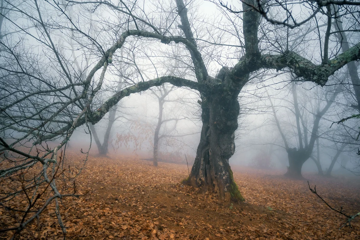
A broad, gnarled chestnut trunk and bare branches stand above fallen brown leaves as surrounding trees fade into mist.

Chestnut trees in mist beside the Fuenteheridos–Castaño del Robledo path, photographed in December 2023.

Castaños en la niebla de Fuenteheridos.jpg — FJavier GómezL / Wikimedia Commons / CC BY-SA 4.0 International · Creative Commons 1 · Creative Commons 2

Walks and routes

Fuenteheridos towards Galaroza: choose your turnaround

The town’s route begins at Plaza El Coso and leads through the village towards the old Galaroza path. Use the municipal directions and current waymarks. For a gentle introduction, walk only as far as suits your group and return by the same way; this is a shortened use of the published route, not a separate marked loop. The full route continues through junctions, old paving and water crossings before crossing the N-433 and following a narrow road into Galaroza. About 5.7 km is one way; doing it all and returning on foot is about 11.4 km. Do not improvise a roadside shortcut.

Expect village gradients and an uneven rural path. The full route has road and stream crossings; it is not presented as wheelchair- or pushchair-accessible. Turn back if the next section is unsuitable.


Fuenteheridos towards Galaroza: choose your turnaround

El Talenque–Valdelarco

A roughly 3 km linear walk follows a small valley and old stone boundaries to Valdelarco. Begin at the signed trail beside El Talenque recreation area near Navahermosa. The Junta rates it low difficulty. With no return transport, retrace the trail: the total is about 6 km, so allow around three hours of walking plus stops. This is a useful separate half-day choice, not an extra leg to bolt onto a Fuenteheridos walk.

Low walking difficulty does not establish step-free access. Ask about the current surface and any wet or damaged sections before choosing it for a mobility aid or pushchair.

El Talenque–Valdelarco

Aracena–Fuenteheridos: the longer crossing

This medium-difficulty linear trail is the substantial option. It passes a changing countryside of chestnut groves, grazed land and traditional stone-walled tracks. The official Aracena start is by the industrial area northwest of town, near the N-433 and opposite the petrol station; use the official leaflet rather than beginning at the visitor centre and assuming the route is obvious. Arrange a pickup or verified connection at the far end, or plan a much longer return walk. The leaflet says no special authorization is needed for this route.

Historic track, gradients and road crossings require sound footing. It is not a step-free route. The official leaflet says there is no dedicated parking at the trail start.

Aracena–Fuenteheridos: the longer crossing

Camino de las Tobas: a short geological stop

Near Higuera de la Sierra, this very short linear path reaches a spring, limestone formations and a small viewpoint above the Barranco del Burro. Water depositing dissolved minerals has built the tufa formations that give the path its name. The approach is from the Higuera–Zufre road, roughly 1.5 km outside Higuera; use the signed start. Allow 30–45 minutes for an unhurried out-and-back and a look at the rock, rather than treating the ten-minute walking figure as the whole visit.

The Junta marks physical accessibility, but its description includes a descending slope and stone-paved sections. Ask about gradient, surface condition and the roadside arrival before relying on it for a wheelchair. Wet stone needs extra care.

Camino de las Tobas: a short geological stop

A relaxed first half-day in Fuenteheridos

Start at Plaza El Coso and check the route information. Give yourselves a short walk towards Galaroza, deciding the turnaround by the least confident walker and leaving plenty of energy for the return. Come back to the village for a break. Allow 3–4 hours overall; if the path is wet or signs are unclear, keep the visit within the village rather than improvising.

A woodland half-day at El Talenque

Bring a cold picnic and begin the signed walk to Valdelarco. If completing the route both ways, budget roughly three hours of walking plus a village stop. Use the recreation area before or after the walk; having a playground and picnic tables does not mean the kiosk, drinking water or toilets will be available.

A fuller park day with an indoor introduction

Visit Cabildo Viejo in Aracena on a confirmed opening morning, then travel to Fuenteheridos for lunch and a short afternoon walk. Allow 6–8 hours including travel and breaks. This two-stop day is best with transport arranged; do not try to fit the full Aracena–Fuenteheridos trail into the gap.

Things to try

Read the woodland as you walk

Compare a chestnut grove’s seasonal canopy with evergreen oak pasture. Look for the signs of management: space beneath trees, boundary walls and access tracks. A wooded landscape can be both a habitat and someone’s livelihood.

Make a small nature notebook

For children, try a three-part challenge: sketch a leaf still on its tree, find a wall with plants growing between stones, and listen quietly for a bird. Use photographs or drawings instead of taking leaves, bark, stones or fungi home.

Go longer only with a return plan

Fuenteheridos also publishes a route to Castaño del Robledo, approximately 6.7 km one way. Its instructions include a road crossing, several forks and a potentially misleading open gate. Save the municipal directions, allow for the return and keep this as an alternative walking day, not a spontaneous extension.

Taste the working landscape

After the walk, look for locally sold chestnuts and regional foods in the villages. Iberian pig husbandry is part of the dehesa story. Visiting a producer requires that business’s own arrangements; seeing livestock beside a public path does not allow entry into its farm.

Birdwatch without chasing a sighting

Use binoculars from ordinary paths and village viewpoints. Watch a distant soaring bird before attempting an identification; avoid approaching nests or following wildlife into private or restricted land. A quiet woodland walk remains worthwhile on a day with few birds.

Understand the landscape indoors

If open, Cabildo Viejo is the most directly relevant wet-weather alternative: its displays connect woodland, livestock, cultivation and water. Check the opening day first, particularly in winter.

Keep the village visit modest

Have a local meal and a brief look around Fuenteheridos, then leave the longer path for drier conditions. If rain is heavy, thunder is forecast or water is running across a route, abandon the outdoor plan rather than searching for an unmarked bypass.

Wildlife and habitats

Cultivated and historically planted chestnut groves; naturalization varies by stand.

Look for the long toothed leaves and, in autumn, spiny fruit cases from the path. These are crop trees as well as part of the scenery; leave the harvest where it belongs.

Domestic livestock raised within the park’s dehesa farming system.

If pigs are visible from a public path, watch from a distance and keep children and dogs beside you. Do not feed, touch or enter their enclosure. A free-ranging farm pig is still domestic livestock.

Wild bird documented for the park, without a specific nest or current sighting location.

A distant dark stork would be a special bonus. Use binoculars from public paths and avoid approaching water-edge refuges or nesting places.

Wild bird documented at park scale; no guaranteed local observation.

Scan the open sky from a safe stopping place. Large soaring birds are easier to enjoy with binoculars; take time before identifying them, and never stop a vehicle in the road.

Wild mammal documented in the park’s river environment; no individual location disclosed.

Think of quiet river habitat rather than an animal you are likely to meet on a short walk. Keep to established paths and leave banks, resting places and wildlife signs undisturbed.

Wild animals choose when to appear. Watch quietly, keep your distance and never use food, calls or nest locations to draw them closer. Stay on public paths, and distinguish working livestock and cultivated trees from wildlife.

Stories and discoveries

Dehesa is a managed landscape

The open oak-and-pasture pattern is maintained through land use, including extensive livestock grazing. It is different from a closed woodland, while still supporting wildlife.

Chestnut woods have a cultivated history

The Andalusian habitat guide describes chestnut formations with historical plantation origins. Some old groves have become more naturalized; actively harvested plots remain cultivated land. Neither category makes the crop free for visitors to collect.

Walls are more than boundaries

On El Talenque–Valdelarco, the official trail account highlights stone walls as places where plants and animals find shelter. Look closely without removing stones or putting fingers into gaps.

A village shaped by water

Fuenteheridos’s municipal history connects its settlement and farming to a spring and irrigation. Its name and street pattern are a reminder to notice water as well as trees during a visit.

When to visit

Spring

Look for the contrast between new deciduous leaves and evergreen oaks. Wet weather may still affect paths, so use footwear with grip and keep a shorter alternative ready. Watch birds from a distance and give nesting wildlife space.

Summer

Start early, shorten the walk and take water even if woodland shade is expected. The 2026 regional notice sets the high-fire-risk period at 1 June–15 October; restrictions and very high or extreme risk can also affect other dates. Check the current notice and plan a cold picnic.

Autumn

Chestnut colour and village food make this an appealing season, but the timing depends on the year. Harvested groves are working land. Fallen leaves and old paving can be slippery after rain; check local hunting and access notices before heading out.

Winter

Expect leafless chestnut trees, cooler breaks and less daylight for returning. Pick a dry day and a shorter route. Check Cabildo Viejo’s exact date before relying on it as an indoor stop, because its winter calendar includes additional closures.

Getting there and practical advice

Cabildo Viejo visitor centre, Aracena

Find it at Plaza Alta, s/n, in upper Aracena. The exhibition explains the park’s landscapes and rural traditions, and staff are the best first contact for practical route advice. The 2026 calendar checked on 17 October lists 09:30–14:00 on opening days, with date-specific closures; check the calendar rather than assuming a fixed weekly pattern. Contact +34 646 490 794 / +34 622 551 878 or [email protected]. Ask ahead about admission arrangements, activities, toilets and the easiest approach.

El Talenque recreation area

Near Navahermosa in Galaroza municipality, the official listing includes picnic tables and benches, a children’s play area, bins and a municipally managed drinks kiosk. Bring your own food and drinking water, and check whether the kiosk is open. The site warns that its water is untreated. It is not a campsite. Built barbecue fixtures are not permission to light a fire; a cold picnic avoids that uncertainty.

Fuenteheridos parking and supplies

The council lists free public parking at Avenida Hermanos Maristas, Calle Reina de los Ángeles by the Castaño del Robledo road, and Calle Médico Enrique González by the cemetery. Follow current signs and leave residential entrances clear. Buy what you need in the village before walking; do not rely on shops or toilets along the paths.

Water and toilets

Carry enough drinking water for your whole walk. A mapped spring or trough is not a guarantee of safe drinking water. Confirm toilet opening and accessible provision at your chosen indoor stop before leaving; this guide does not identify a verified public toilet at a rural trailhead.

Arriving by road

The N-433 and N-435 are the main regional approaches. Navigate to the particular village or facility you chose, rather than to a generic park pin. Use Fuenteheridos’s designated public parking and walk into the village; leave space for residents and farm vehicles. Allow extra time for the narrower local roads between stops.

Using buses

Fuenteheridos’s council identifies a Damas connection with Sevilla’s Plaza de Armas; Damas also lists Aracena and other regional routes. Check the operator for your exact date, stops and return service before building a walk around a bus. Older municipal timetable and fare tables should not replace that check. There is no park-wide shuttle assumed in these plans.

Finishing a one-way trail

Book or arrange your onward transport before starting, or choose a same-way return within your group’s ability. The route’s published distance normally describes one direction. Mobile coverage and an available taxi at the finish should never be the only return plan.

Cabildo Viejo: arrange the approach

The Junta lists physical, visual and hearing accessibility at the centre. Its position in the higher part of Aracena means the streets on the way can be a separate obstacle. Ask staff about a suitable drop-off, step-free entry, movement between exhibition levels and accessible toilets.

Camino de las Tobas: short is not necessarily level

The route has an official physical-accessibility marker and is only 359 m one way, but the same description mentions a descending slope and paving. Confirm surface condition and whether your wheelchair or other mobility aid can manage the return climb.

Countryside paths and El Talenque

Do not transfer a recreation area’s accessibility symbol to the full Valdelarco trail. Old surfaces, slopes and wet sections can change what is manageable. For pushchairs or limited stamina, choose a short section you can inspect and reverse, or ask for a village-based visit.

Visitor information

Check Minas de Teuler before planning a ride

On 17 October 2026 the official English page still marked the Minas de Teuler cycle route temporarily closed, while the Spanish page did not show the same flag. Confirm reopening with the park before using it; it is not included among the routes recommended here.

Sources and useful links

Wildlife you might spot

5

Each card links to a full Explore page with photos, traits, and fun facts.

Snap map for this place

Start with the big picture, then zoom in to explore individual wildlife observations around this place.

Loading map…

Good to know before you go

Choose the full route before leaving the village. A sign pointing to another village does not mean a short circular walk.

Take drinking water, a snack and footwear with grip. Treat springs and recreation-area water as unsuitable for drinking unless marked potable.

Stay on signed public paths. An open gate is not an invitation into an orchard or livestock enclosure; leave gates as you found them.

Keep children close at road crossings and around animals. Give livestock space, never feed it, and keep dogs under close control.

Look at chestnuts and fungi where they grow. Buy produce locally rather than collecting from someone else’s land; never eat mushrooms based on a casual identification.

Check for forestry work, hunting notices, storm damage and fire restrictions. A route page is not a guarantee that every section is open today.

Arrange the return before a one-way walk. Do not assume there will be a convenient bus or taxi when you reach the next village.

Carry a charged phone and save the official route information offline. Tell someone your plan; call 112 in an emergency.

Frequently asked questions

It is a broad inhabited landscape, reached through several towns and villages. This guide starts in Fuenteheridos. Individual museums, caves, guided activities and other attractions have their own arrangements; check those separately.
A short out-and-back from Fuenteheridos towards Galaroza keeps the return under your control. The complete municipal route is about 5.7 km one way and later includes rough paving, stream crossings and the N-433 crossing. Turn back well before those later sections if your group needs an easier outing.
The official route is 11.294 km one way, with a published four-hour walking time and medium difficulty. Reversing it makes roughly 22.6 km before any village detours. Choose a shorter outing or arrange transport at the far end.
The official Aracena–Fuenteheridos leaflet states that special authorization is not required for that route. Other activities, restricted areas and temporary closures can have different conditions. Check your chosen trail with the visitor centre, especially for an organized activity or anything beyond ordinary signed-path walking.
The chestnut groves are working land and much of the park is privately owned. Do not assume produce is free to take. Use a locally organized activity with the necessary permission, or buy chestnuts and mushroom dishes from local businesses.
Start by asking Cabildo Viejo about a suitable visit. Its accessibility provisions and Camino de las Tobas’s physical-accessibility listing are facility-specific; neither makes all village streets or woodland paths accessible. Ask about the precise approach and facilities you need.
The official 2026 calendar checked on 17 October shows 09:30–14:00 on opening days. Closed days vary, including holiday and winter exceptions. Check your date on the Cabildo Viejo page or call +34 646 490 794 / +34 622 551 878 before travelling.
Use Cabildo Viejo, if open, and keep any village stroll short. Persistent rain is a good reason to skip streamside paths and slippery paving; an indoor visit can explain the landscape for your next walk.

Recent snaps at this place

Recent snaps will appear here as new observations are added.

View all ›

Take the discovery with you

Exploring Sierra de Aracena and Picos de Aroche Natural Park?

Identify the wildlife you spot, learn as you go, and keep a collection of the adventure.

  1. 1Spot it
  2. 2Snap it
  3. 3Keep the discovery