Snappit logo
Snappit
Get App
Generic illustration, not a photograph of this venueIllustration
ParkGalicia, Spain

Baixa Limia–Serra do Xurés Natural Park

Start small in the Xurés.

About

Start small in the Xurés. These granite mountains spread across southern Ourense, but a first visit need not involve a summit or a border-crossing drive. Make Lobios your starting point, ask at the interpretation centre about the day’s conditions, then choose one valley outing. The contrast between rounded rock, scrub-covered slopes and greener river margins is enough to give the landscape its character.

For a walking family, the Río Vilameá route offers a compact story: water flowing through the valley, stone mills and the woodland around them. Take time to work out how the mills used the river. The optional path to an alvariza, a protective enclosure for beehives, is harder and changes the outing’s difficulty, so it is perfectly sensible to leave it for another visit.

There is also a nearby adapted riverside section at Riocaldo, useful when your group needs a different kind of outing. Either choice works better than trying to tick off every waterfall, village and mountain trail in one afternoon. This guide covers Spain’s Baixa Limia–Serra do Xurés Natural Park. Portugal’s neighbouring Peneda-Gerês National Park has its own access arrangements; the Gerês-Xurés biosphere reserve is a wider, cross-border designation. Wondering what that bird or insect is? Find out on your visit using the Snappit nature app.

The landscape has been lived in and worked for centuries. Mills show how flowing water helped process grain; walled apiaries reflect the effort involved in protecting valuable beehives. Elsewhere in the park, megalithic monuments and milestones from the Roman road between Braga and Astorga add much older layers to that story. The natural park was declared in 1993 and expanded in 2009. Today it extends across six municipalities in Ourense. Its relationship with the neighbouring Portuguese mountains helps explain the wider Gerês-Xurés biosphere reserve, but the natural park remains a distinct Spanish protected area. Looking at both woodland and worked land is part of understanding it.

What to do here

Visit the Lobios interpretation centre, then choose the Río Vilameá mill circuit or ask about the nearby adapted Riocaldo riverside section. Keep time for looking at plants, listening to the river and a relaxed lunch rather than adding a second mountain route.

Seasonal info

Summer can be hot and dry, with fire risk. After heavy rain, river conditions matter more than the season on the calendar. Higher ground can be cold and exposed while the valley feels mild; a short valley visit does not prepare you for a mountain hike.

Accessibility

Río Vilameá is a low-to-medium difficulty walking trail. If you use a wheelchair or pushchair, ask staff about a suitable alternative. Nearby Riocaldo has a 1,250 m adapted riverside section; confirm its present condition, access point and suitability for your mobility aid before travelling. Ask separately about access and toilets at the Lobios centre.

Don't miss

1

Get your bearings at the park’s interpretation centre in Lobios.

2

Follow the Río Vilameá’s stone mills on a short circuit.

3

Notice the change from river woodland to granite and scrub.

4

Choose the nearby adapted Riocaldo section when it better suits your group.

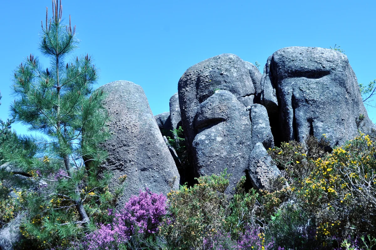
Tall rounded granite boulders rise among pine branches and purple- and yellow-flowering scrub beneath a blue sky.

Rounded granite boulders and flowering scrub in Baixa Limia–Serra do Xurés Natural Park, photographed in May 2015.

Penedos - WLE Spain 2015.jpg — Raúl Hidalgo / Wikimedia Commons / CC0 1.0 · Creative Commons

Walks and routes

Río Vilameá: the short mill circuit

The official circuit starts and finishes at Vilameá, follows both banks and passes a series of up to twelve mills, some restored. It is 1.7 km, rated low-to-medium difficulty, with a published walking time of 45 minutes. Allow longer for stops. The roughly 450 m path to the alvariza is an out-and-back detour; the official description raises difficulty to medium-high if you add it. The main circuit makes a more manageable first visit.

This is a walking path with river-edge hazards. If your group needs step-free access or is travelling with a pushchair, ask staff whether the nearby Riocaldo option would be more suitable.


Río Vilameá: the short mill circuit

Nearby Riocaldo: the existing adapted section

For a different kind of valley outing, ask about the adapted riverside section at Riocaldo. The 1,250 m stretch runs along the right bank of the río Caldo between the thermal area and a recreation/rest area. That is the published section length, not a round-trip distance. Decide how far to go and how to return before starting; a further extension was only under consideration in the April 2026 notice.

Xunta reports adapted surfaces and walkways, ramp handrails, edge guides and adapted tables, benches and supports. Confirm parking/drop-off access, gradients, toilets and current usability for your own mobility needs.

Nearby Riocaldo: the existing adapted section

A relaxed half-day around Lobios

Allow 30–45 minutes at the centre if it is open, then travel to Vilameá and give the main mill circuit 60–90 minutes with stops. Return for lunch rather than adding a steep route at the last minute. These are suggested allowances; they exclude your journey to Lobios and depend on the group.

A plan with mobility needs in mind

Contact the centre first about its entrance and facilities, then confirm the existing adapted Riocaldo section with local staff. Choose a manageable distance and return arrangement. If conditions do not suit your group, keep the interpretation stop and save the riverside visit for another day.

Things to try

Follow the water’s work

At the mills, look for the relationship between the building and the watercourse. Try explaining how moving water could do useful work before you read the signs. Keep to the path rather than entering structures or climbing on masonry.

Compare two kinds of green

Notice how the feel of the vegetation changes between a damp river margin and an open scrubby slope. Make a small sketch or take a close-up from the path; leave leaves, flowers and acorns in place.

Watch quietly, without a chase

Pause in a safe place and listen before lifting binoculars. A distant bird is worth watching even if you cannot name it. Give livestock and the people working this landscape plenty of room.

Let the interpretation centre be the visit

If the centre is open, spend longer understanding the landscape and choosing a future walk. On a day with heavy rain, storms or unsafe river levels, postponing the outdoor part is a better choice than forcing a circuit.

Wildlife and habitats

Pedunculate oak

Look at the rounded lobes and short leaf stalks, and notice how the canopy changes the light. This oak belongs to the park’s woodland and is documented along the río Vilameá; compare leaves without picking them.

Strawberry tree

Its glossy, toothed evergreen leaves offer a useful contrast with deciduous oak. The park’s warmer woodland and scrub support this species. If you find rounded, knobbly red fruit, admire it without collecting.

Common heather

Look closely at the tiny, overlapping leaves on this heathland shrub. A patch of scrub can hold far more detail than it first appears to from the road; investigate from the path rather than trampling into it.

Sweet chestnut

Long, sharply toothed leaves and prickly fruit cases help it stand out. Chestnuts belong to the area’s cultivated history: old groves and their surviving trees tell a story about food and land use. Leave the crop for its owners and wildlife.

Golden eagle

Look across the open mountain skyline with binoculars when the weather is clear. Golden eagles are part of the park’s conservation story, including work to reinforce the wild population. Watch distant birds without approaching their resting or breeding places.

Common crossbill

In pine woodland, pause to listen and look into the canopy from the path. Common crossbills are among the birds highlighted by the official park birding guide. Take time over identification rather than naming every small bird overhead.

These are plants and birds documented in the park, rather than a checklist you should expect to complete on the short outing. Enjoy whatever is there, stay on permitted paths, keep your distance and never pick plants, feed animals or seek out nests.

Stories and discoveries

A landscape shared across a border

The same mountain system continues into Portugal, while the two parks remain separate protected areas. The biosphere designation links a wider inhabited landscape around them.

An apiary with walls

An alvariza is a traditional enclosure built to protect beehives. The park brochure connects these walls with the historical presence of bears in the mountains. They are a reminder of the practical problems that beekeepers once faced.

When to visit

Dry and hot

Shorten exposed walking, carry water and check fire restrictions before leaving. Do not light a fire, even for a picnic. A cool start is more useful than squeezing in extra distance.

Wet or cold

Keep to a shorter plan when rain has made stone slippery or rivers are rising. Leave the higher trails for suitable weather and preparation. Do not trade a wet riverside path for a more demanding mountain route.

Getting there and practical advice

Lobios interpretation centre

The park’s information gateway is at Carretera de Portugal, 34, Lobios. The official brochure lists +34 988 788 761 and [email protected]. Confirm opening, toilet access and any guided activities in advance; published web schedules are inconsistent.

What to sort out before the path

Ask where to park for the specific walk and where the nearest available toilet is. Carry the drinking water and food you need rather than counting on facilities beside the mills. Use only authorised parking.

Lobios first, then the trailhead

Plan the centre and your chosen walk as separate stops. The Río Vilameá description approaches Vilameá from the OU-312 and turns by Santa Lucía chapel; follow current route signs rather than an approximate park-centre pin. Drive cautiously on the area’s narrow, winding roads.

If you are travelling without a car

Arrange both the onward trip from Lobios and the return before choosing a rural trailhead. Ask the centre or your accommodation about local travel options and verify any bus timetable for your actual day. Check whether the service reaches your trailhead and how you will get back.

Keep the two valley options distinct

Ask about the mill route’s surfaces and crossings before attempting it with a pushchair. For wheelchair users, start with an enquiry about Riocaldo’s adapted section and explain your individual needs. Check the centre’s entrance and toilet provision separately.

Sources and useful links

Wildlife you might spot

6

Each card links to a full Explore page with photos, traits, and fun facts.

Snap map for this place

Start with the big picture, then zoom in to explore individual wildlife observations around this place.

Loading map…

Good to know before you go

Confirm the centre’s opening and your chosen path’s condition before setting out. The park webpage contains conflicting opening-hour summaries, so use the park contact rather than relying on one timetable.

For Río Vilameá, follow the official trailhead signs from Vilameá. The turn beside the Santa Lucía chapel leads towards the route; the interpretation centre in Lobios is a separate stop.

Wear shoes with good grip and bring drinking water, sun protection and a waterproof layer. Keep children close by the river; wet rock can be very slippery.

Stay on signed paths, use designated parking and leave rocks, plants and fallen natural material where they are. Do not light fires or camp freely.

Treat the alvariza detour as an extra decision: the official route description raises its difficulty to medium-high. Do not add it merely because the main circuit is short.

Keep dogs on a lead and check the rules for your exact route. The integral reserve excludes dogs apart from specified exceptions, and sensitive areas may have further restrictions.

Do not assume that a pool mentioned in a route description is currently authorised for bathing. Check signs and ask the park; swimming is restricted to authorised areas.

Give grazing livestock room and let them pass. Keep wildlife watching quiet, carry your rubbish out and use 112 for an emergency.

Frequently asked questions

No. Baixa Limia–Serra do Xurés is the Spanish natural park in Galicia; Peneda-Gerês is the neighbouring Portuguese national park. Both contribute to the wider cross-border biosphere reserve. A route or permission on one side does not automatically apply on the other.
Start by asking about Río Vilameá. Its published circuit is 1.7 km and takes around 45 minutes without long stops, but its low-to-medium rating still calls for sure footing and supervision beside water. Skip the harder apiary detour if the group is tired or the ground is wet.
The park specifically requires written advance communication for A Cela–Pitões and Torrente–Salgueiro when crossing the regulated Salgueiro area. Access to the reserve zone requires authorisation. Ask the park about your chosen itinerary, especially for an organised group; the short options here do not grant access to restricted areas.
Check the exact area with park staff and keep your dog on a lead. The management plan has zone-specific restrictions, including exclusion from the integral reserve except for guide and rescue dogs. Do not rely on the park webpage’s generic pet advice alone.
Ask about the existing adapted section beside the río Caldo at Riocaldo. Xunta documented 1,250 m of adapted surfaces and walkways, with ramp rails and adapted seating, in April 2026. The same notice discussed a possible extension; it did not announce its completion. Confirm access, return arrangements and present conditions.
Contact the centre before you travel, especially outside summer and around holidays. The official page shows inconsistent schedules. The park brochure lists +34 988 788 761 and [email protected].

Recent snaps at this place

Recent snaps will appear here as new observations are added.

View all ›

Take the discovery with you

Exploring Baixa Limia–Serra do Xurés Natural Park?

Identify the wildlife you spot, learn as you go, and keep a collection of the adventure.

  1. 1Spot it
  2. 2Snap it
  3. 3Keep the discovery