
Snappit logo
Snappit
Get App
Generic illustration, not a photograph of this venueIllustration
ParkCastilla-La Mancha, Spain

Serranía de Cuenca Natural Park

Uña makes the scale of these mountains easy to understand.

About

Uña makes the scale of these mountains easy to understand. Look across the lagoon and the landscape stacks itself into layers: open water, reeds, pale rock walls and forest above. The temptation is to keep moving towards the next viewpoint, but a slow first stop gives you time to notice how much is happening between the village and the cliffs.

The natural park protects a broad stretch of the southern Sistema Ibérico in Cuenca province. Its pine woods and flat-topped heights, locally called muelas, are cut by rivers and broken into limestone landforms. This guide keeps a first visit centred on Uña rather than trying to fit the whole protected area into one drive.

Use the visitor centre to make sense of the lagoon. Its displays explain water, rock and living things together, and its viewing area is a useful place to settle down with binoculars. A short visit here can be a complete outing: you do not have to climb above the cliffs to enjoy the setting.

For walkers with the right footwear, time and weather, El Escalerón y La Raya offers a much bigger change of perspective. That official circuit climbs to the Muela de la Madera and returns through rocky terrain. Decide on it before you start, with the whole group in mind. A lake in the name or view does not make this a level waterside walk. Turn your visit into a safari! Use the Snappit app to scan and log wildlife sightings here.

The natural park was declared on 8 March 2007. Its boundary was expanded in 2020 to include land in Huerta del Marquesado. The landscape also records a much longer relationship with people: forestry, grazing and village life form part of the park’s story. At Uña, the exhibition shows the lagoon before it was raised, a reminder that this attractive body of water has a history of human alteration as well as natural formation.

What to do here

Visit the Uña centre when it is open, look across the lagoon from the viewing area and give the waterbirds an unhurried spell of attention. If you want a longer outing, choose the signed El Escalerón y La Raya circuit as a separate hiking plan after checking conditions. Keep the rest of the day flexible for a meal or a quiet village stop.

Seasonal info

The Uña centre opens on selected dates, not every day throughout the year. Its 2026 calendar runs from late March to late November, with different morning-only and split-day hours. Spring weather can change quickly; summer brings heat and fire precautions; autumn rain can leave rock slippery. Short winter days and shaded ice can make the high circuit a poor choice even when the village is reachable.

Accessibility

The authority identifies the Uña visitor centre as suitable for people with reduced mobility and lists parking, toilets and a viewing area. Ask staff about the exact step-free route and toilet facilities you need. That building-level information does not cover the mountain circuit: El Escalerón y La Raya is a medium-difficulty route with climbing and rocky passages, unsuitable as an independent wheelchair or pushchair itinerary.

Don't miss

1

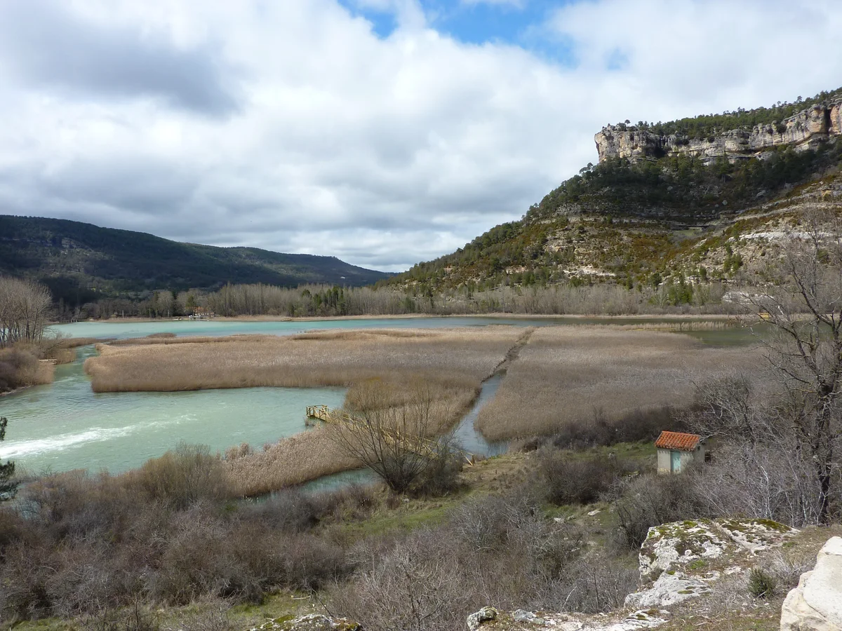
Laguna de Uña’s water, reed fringe and limestone backdrop

2

The Uña centre’s explanation of how a mountain wetland works

3

Pine-covered muelas and the river-cut landscape

4

The higher views on El Escalerón y La Raya, for prepared walkers

Pale turquoise lagoon channels among extensive reedbeds beneath the rocky cliffs near Uña.

Laguna de Uña and its reedbeds in the Serranía de Cuenca, photographed in April 2010.

Vista de la laguna de Uña desde el Barranco del Socarrado.jpg — Esteban Javier Millan Rivas / Wikimedia Commons / CC BY-SA 4.0 · Creative Commons

Walks and routes

El Escalerón y La Raya: the full mountain circuit

A signed 9 km circular walk from Uña, officially rated medium difficulty. It climbs through the Escalerón to the Muela de la Madera, continues through pine country with viewpoints, and returns through La Raya’s rocky passage. Allow 3–4 hours with stops. Start only if everyone is comfortable with sustained walking, rough ground and heights.

This is a mountain path with ascent and rocky sections, not a wheelchair or pushchair circuit. A shorter distance on a map would not remove these barriers. Keep younger children close and choose the centre-based outing if the whole route is too much.


El Escalerón y La Raya: the full mountain circuit

A gentle first taste: 1–2 hours

Choose a day when the centre is open. Spend around 30–45 minutes with the exhibition, then pause at its lagoon viewing area. Add a short wander in the village if it suits your group. Keep this a flexible outing, with time to sit, look and turn back whenever you have had enough.

A walking half-day

Check the forecast and route advice before committing to the 9 km circuit. Give the walk 3–4 hours with breaks, and leave spare time for the exhibition if its opening hours fit. Do not add distant attractions just to fill a checklist; return while there is ample daylight.

With a second day

Choose another park gateway, such as Tragacete or Valdemeca, and build a fresh plan around its centre and an appropriate official trail. If you prefer Ciudad Encantada, check that attraction separately. Each choice deserves its own travel and visiting time.

Things to try

Give the lagoon ten quiet minutes

Settle at an authorised viewing place, put the binoculars down for a moment, and watch how different birds move. Some stay on the surface; others disappear beneath it. Let children sketch one shape or behaviour rather than trying to collect a long list of names.

Read the landscape in layers

From the lagoon setting, look for water, reed fringe, cliffs and the forested top. At the centre, use the water model to connect what is visible outdoors with processes that are harder to see. This works well even if your group decides against a hike.

Use the exhibition, if it is open

On a wet day, the water-themed displays offer a reason to visit without making a mountain circuit. Confirm opening first. Shorten any outdoor stop if the surface is slippery, visibility poor or wind strong; an exhibition does not make the journey safe in severe weather.

Leave the climb for another day

Choose a village meal or return to your base instead of following a route through wet rock or a storm. Mountain scenery can wait. If driving conditions are poor, reconsider the whole outing rather than moving from one remote viewpoint to another.

Wildlife and habitats

Eurasian coot

Look for a dark waterbird with a white bill and forehead shield. Compare its shape with ducks on the water, using binoculars from the viewing area.

Little grebe

Watch for a small, rounded waterbird that dives and resurfaces elsewhere. Following its movements is often easier than trying to photograph every brief appearance.

Mallard

Spend a moment comparing ducks rather than assuming they all look alike. Use a field guide to check the different plumages, and watch from the path without offering food.

Griffon vulture

Scan the sky from a safe standing place for large soaring birds. Watch the broad wings and use binoculars to check an identification; keep well back from cliff edges.

Scots pine

The wider park includes Scots-pine woodland. Use the centre’s displays to learn how its pines differ before trying to name every tree you pass. Photograph details in place rather than pulling off needles or cones.

These are documented inhabitants to look out for, not a sightings checklist you are expected to complete. Stay on public paths, leave birds and their cover undisturbed, keep noise low and enjoy whatever the day offers.

Stories and discoveries

A natural dam, with a human history

The lagoon began where tufa deposits held back the Arroyo del Rincón. The centre’s model shows the earlier form before the water level was raised. Looking at that model first can make the real shore much more interesting than a quick photograph.

Why the forest changes

High ground, shaded gorges and river edges create different growing conditions within the same park. The landscape is a mixture of pine woodland, broadleaved trees and wet places, rather than one uniform forest. Notice the change in shade and vegetation without leaving the path.

When to visit

Spring and autumn

Make the most of mild conditions, but carry an extra layer and keep an eye on the forecast. After rain, decide whether the high circuit still makes sense. A shorter visit can leave more time for watching birds and examining the centre’s displays.

Summer

Start a longer walk early enough to avoid the hottest part of the day, carry all the water you need and check current fire-risk restrictions. An earlier start is not permission to enter a closed area. Avoid being on high or exposed ground when thunderstorms threaten.

Winter

Check road conditions, daylight and the centre’s current calendar. Do not expect the summer programme or an open indoor refuge. If there is snow or ice, keep the visit within conditions and terrain that your group can manage, or postpone it.

Getting there and practical advice

Uña visitor centre

The centre is at Calle de la Fuente, s/n, beside Laguna de Uña. Its official listing includes an exhibition, audiovisual room, viewing area with telescope, toilets and parking. Bring your own binoculars if you have them, and ask staff which equipment and facilities are available that day.

Seasonal opening

Use the 2026 date grid rather than assuming daily opening. The calendar highlights selected days between 28 March and 29 November; some are morning-only and others include an afternoon session. The exact hours for each colour are in the questions below. Check the new annual calendar before travelling in another year.

Information and organised visits

The official centre page lists +34 969 247 843 and additional local contact numbers. The park email is [email protected]. Contact the centre in advance for a group, an organised activity or particular access needs; a place on a guided event is a separate arrangement from an independent visit.

Separate tickets and services

Ciudad Encantada has its own ticket office, prices, opening times and walking conditions. Confirm the current cost directly if you add it to your trip. For food, bring a snack and check village businesses before relying on a meal at a particular time.

Getting to Uña

Plan for Uña village and its visitor centre, rather than a general map pin for the entire park. The regional tourism authority lists the CM-2105 among the approaches from Cuenca. Allow flexibility for mountain roads, weather and stops, and follow road signs over any suggested forestry-track shortcut.

If you are not driving

Arrange a reliable outward and return journey to Uña before setting off. Ask your accommodation or the centre about suitable local transport for your date; do not build the day around an assumed frequent bus or an unbooked taxi pickup. The hiking circuit returns to Uña, but that does not solve the journey back to your base.

Keep the accessible visit specific

The Uña centre’s reduced-mobility designation is a useful starting point. Before travelling, ask about the parking-to-entrance route, thresholds, toilet layout and access to the viewing area. Say what you need, such as a wheelchair turning space, a short walking distance or somewhere to sit.

Avoid an accidental difficult detour

El Escalerón y La Raya is the higher, rougher choice. The travertine viewpoint is another separate place, and official tourism information warns that access can be difficult for people with reduced mobility. Neither should be added automatically to a centre visit.

Sources and useful links

Wildlife you might spot

5

Each card links to a full Explore page with photos, traits, and fun facts.

Snap map for this place

Start with the big picture, then zoom in to explore individual wildlife observations around this place.

Loading map…

Good to know before you go

Check the Uña opening calendar before travelling. The centre lists +34 969 247 843 and local numbers on its official page; ask about the weather, signs and any restrictions affecting your exact plan.

Bring drinking water, a snack, a warm layer and shoes with grip. Do not rely on finding a working fountain or an open café along a mountain route.

Use the signed paths and take the official route details offline. If your plan is only a lagoon stop, do not accidentally follow the full 9 km circuit uphill.

Keep children beside you near water and cliff edges. Stay back from drops and do not climb or lean on railings; the park warns that these can be boundary markers rather than fall protection.

Keep your dog close and under control; a lead is the simplest choice near birds, other walkers and livestock. Watch quietly and leave nests, reeds, flowers, rocks and fallen wood undisturbed.

No fires or wild camping. Drone use requires authorisation. Follow current notices and any instructions from park staff, including temporary closures.

Park only in permitted areas without blocking village streets or emergency access. Arrange your return transport before setting out if you are not driving.

Treat Ciudad Encantada as a separate, privately managed paid visit. Check its own ticket and opening information; the Uña centre calendar does not apply to it.

Frequently asked questions

At the Centro de Recepción de Visitantes de Uña, Calle de la Fuente, s/n, in Uña village beside the lagoon. Check its opening date first. It is one gateway to a large natural park; the other visitor centres are in Tragacete and Valdemeca.
Do not assume the signed circuit is a flat lake loop. El Escalerón y La Raya is 9 km, officially medium difficulty, and climbs into the cliffs and plateau. For a short visit, use the centre’s lagoon viewing area and ask staff which nearby public paths suit your group.
Use the date-specific calendar. For 2026, green dates are 09:30–14:00 and 16:00–18:30; orange dates are 09:30–14:00 and 16:30–19:00; yellow dates are 09:30–14:30. Only highlighted dates are scheduled openings. Confirm before a special journey and use a new calendar for later years.
The park’s visitor guidance treats ordinary hiking as an activity that normally needs no prior authorisation. Check the current regulations and local notices before going. Organised activities, guided events and other sports can have their own booking or permission requirements.
The natural park is the wider protected landscape. Ciudad Encantada is a separately managed paid attraction within it. El Hosquillo is a separate animal facility and is not part of this suggested visit or its wild-species selection.
The centre is officially listed for visitors with reduced mobility, but ask about your particular access and toilet needs. Confirm the current viewing-area access too. Do not extend that description to the mountain circuit or the travertine viewpoint, where the regional tourism page warns of access difficulties.
Boating is prohibited on Laguna de Uña under the park’s published rules, so do not bring a kayak or paddleboard for this outing. Enjoy the lagoon from land. If you want to swim elsewhere, ask the park about the particular place and current conditions; an attractive waterbody is not necessarily a supervised bathing area.

Recent snaps at this place

Recent snaps will appear here as new observations are added.

View all ›

Take the discovery with you

Exploring Serranía de Cuenca Natural Park?

Identify the wildlife you spot, learn as you go, and keep a collection of the adventure.

  1. 1Spot it
  2. 2Snap it
  3. 3Keep the discovery








