
Snappit logo
Snappit
Get App
Generic illustration, not a photograph of this venueIllustration
ParkAndalucía, Spain

Sierra de Grazalema Natural Park

Start small in Grazalema.

About

Start small in Grazalema. This is a whole mountain landscape, with white villages, wooded valleys and high limestone country, so a rewarding first morning need not involve a summit. El Bosque is a practical gateway: begin with the visitor centre, then choose a short riverside walk or the botanical garden. Save a permitted reserve walk for a day when you have the booking, weather and energy for it.

Water gives these mountains much of their character. Moist Atlantic air reaches the ridges, rain works its way through fractured limestone, and springs feed green corridors below. The Majaceite lets you explore that contrast at close quarters. Higher up, the native pinsapo fir forms the forest for which the park is especially known. El Castillejo’s planted collection is a useful introduction before seeking the wild forest.

Build the day around one part of the park. El Bosque and Benamahoma suit the western introduction suggested here; the Málaga-side villages and Guadiaro valley deserve their own outing. A pretty river does not automatically make a swimming spot, and a short line on a map does not make an easy mountain walk. Choose a route for the least confident walker in your party and leave room to turn back. Eager to name that creature? Identify any animal you find during your visit using the Snappit app.

Grazalema’s protected landscape is also a working landscape. Grazing, cork, farming and water-powered industries helped shape the woods and villages. The mills and fulling works associated with the Majaceite tell part of the story of flour and wool production. Recognition as a UNESCO biosphere reserve came in 1977, followed by natural-park protection in the 1980s, commemorated locally in 2025 as the park’s fortieth anniversary. That human story makes a village stop a natural part of the visit.

What to do here

Get your bearings in El Bosque, spend time watching the river from an open section of the signed Majaceite path, and visit El Castillejo if its opening hours fit. For another short outing, consider the official El Tesorillo loop from Los Llanos del Campo. Choose the longer reserve routes separately and arrange their permissions first.

Seasonal info

From 1 June to 15 October, the four principal reserve routes have different fire-season limits: El Torreón closes, El Pinsapar is restricted to a company-accompanied out-and-back approach, Llanos del Rabel is shortened, and ordinary Garganta Verde hiking is unavailable. The end of the seasonal period does not override a weather or works closure. See the individual routes and current-access notes below.

Accessibility

Plan accessibility by stop. El Bosque visitor centre and El Castillejo advertise accessibility provision, but ask about the exact entrance, toilets and paths you need. Los Llanos del Campo has reserved parking and some wheelchair-adapted picnic tables. Do not assume that the Majaceite trail, its bridges or any mountain route is suitable for a wheelchair or pushchair.

Don't miss

1

The Majaceite’s green riverside woodland, explored at your own pace

2

El Castillejo’s living introduction to mountain plants and the pinsapo

3

Short woodland walks from Los Llanos del Campo

4

A separately planned, permitted visit to the Sierra del Pinar reserve

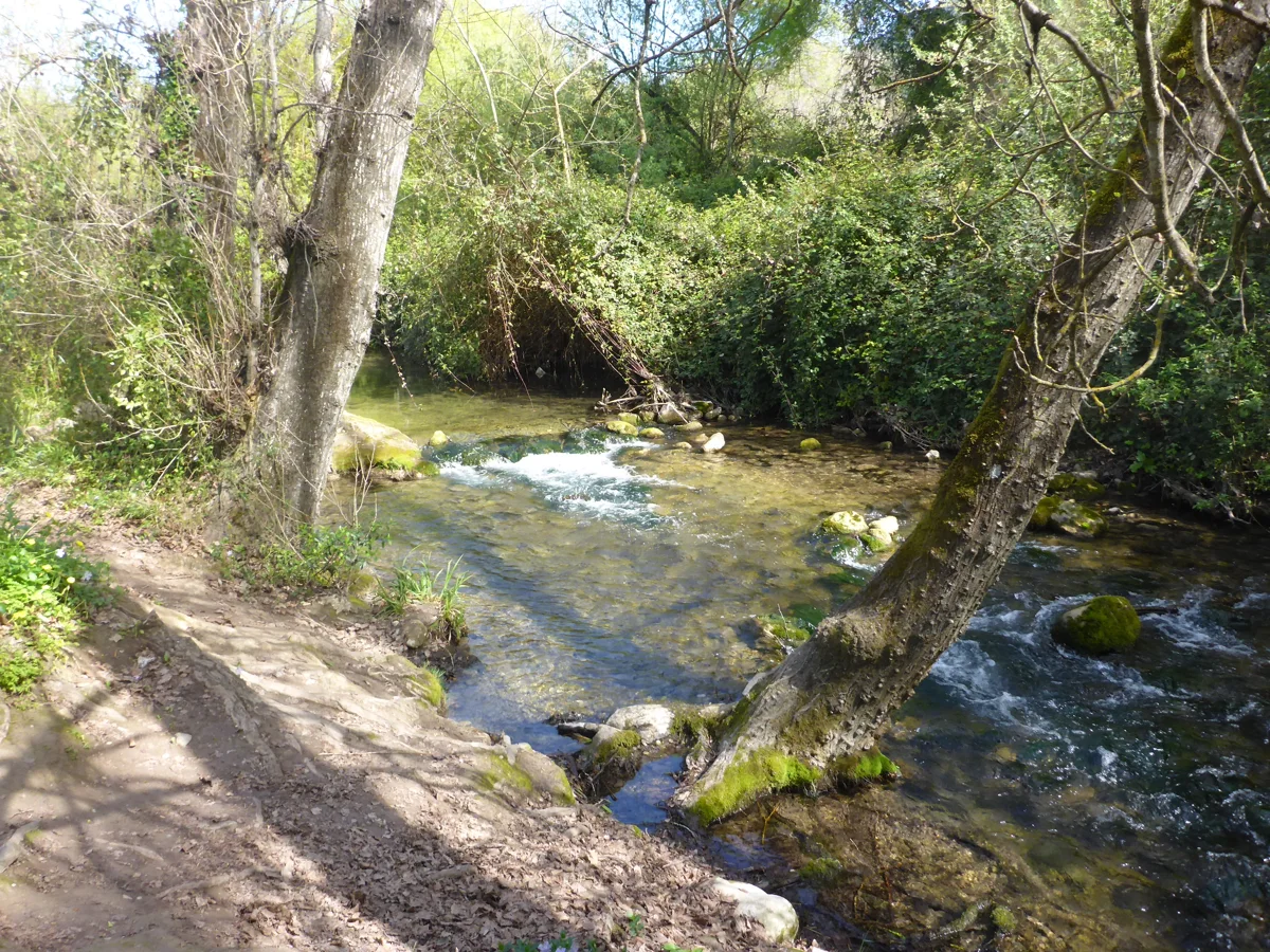
A shallow river runs over mossy stones beside trees, dense shrubs and a narrow earth bank.

The Río Majaceite at El Bosque in March 2020.

Río Majaceite - P1460118.jpg — El Pantera / Wikimedia Commons / CC BY-SA 4.0 International · Creative Commons 1 · Creative Commons 2

Walks and routes

A short Majaceite out-and-back from El Bosque

After checking the open access, follow signs from El Bosque towards the official trail start at Molino de Enmedio and stay on the riverside path. Set aside 20–30 minutes outward, then return the same way, stopping sooner if anyone is tired or the surface is uncomfortable. Pause somewhere wide enough to let others pass and compare the sound of flowing water with the quieter woodland.

This is a shortened part of a walking trail, not an accessible-path designation. Ask about bridges, uneven surfaces and any temporary diversion before bringing a pushchair or mobility aid.


A short Majaceite out-and-back from El Bosque

The complete Río Majaceite circuit

Choose this only when everyone wants a sustained walk. The current loop combines the riverside section with a higher return through Mediterranean woodland, passing near El Castillejo. Read the current trailboard rather than following the older linear-route leaflet.

Officially medium grade. The higher return adds a different walking demand from the valley floor; do not judge the complete circuit by the first riverside stretch.

The complete Río Majaceite circuit

El Tesorillo: a compact woodland loop

Start at Los Llanos del Campo and follow the signed circular trail. It gives a manageable taste of woodland and old working paths without making the river crossing the centre of your day. Leave time to sit quietly and listen before returning to the picnic area.

Low difficulty is a walking grade, not proof of a step-free surface. Ask staff about present footing if a rough patch would prevent your group completing the loop.

El Tesorillo: a compact woodland loop

Arroyo del Descansadero: a small stream valley

This signed path links the upper entrance of Benamahoma with Los Llanos del Campo. Springs and the remains of an old mill make useful things to look for without leaving the route. If starting in Benamahoma, take care at the A-372 access beside the bus stop.

Officially low grade but a natural walking path. Roadside access and the return journey need separate consideration; it is not a verified wheelchair route.

Arroyo del Descansadero: a small stream valley

Llanos del Rabel: the gentler reserve option

This route offers views towards Sierra del Pinar and a gradual approach through Mediterranean vegetation. Decide before booking whether the full return distance suits your group. A low-grade reserve walk can still be a long day for small children.

The operator describes a gentle alignment and firm surface, but does not establish wheelchair access throughout. Obtain advice for your own equipment and turning needs.

Llanos del Rabel: the gentler reserve option

El Pinsapar: a planned mountain-forest day

The usual linear itinerary begins at Canteras above Grazalema, climbs over Puerto de las Cumbres and continues towards Benamahoma. Arrange the end-of-walk transport before you start; reversing the full route is a much bigger undertaking.

Officially medium grade with an ascent and mountain footing. This is not an alternative for someone who needs a short, level garden walk.

El Pinsapar: a planned mountain-forest day

El Torreón: for an experienced walking day

Keep this summit walk for a fit, well-equipped party in good conditions. The official short-looking distance is the uphill leg only. Allow generous time and energy for the descent, and turn back if wind, cloud or footing makes progress uncertain.

High difficulty. A steep mountain ascent is unsuitable as the introductory family stroll suggested in this guide.

El Torreón: for an experienced walking day

Garganta Verde: plan with the park before booking

Treat this as a specialist choice rather than an add-on to a village lunch. The official page distinguishes walking from canyoning and gives a further warning about the final approach to La Ermita. Confirm the precise hiking turnaround, equipment and authorized activity with the park.

A gorge route with serious terrain and natural hazards; not a casual family stroll or an accessible trail. Canyoning needs relevant skills and equipment.

Garganta Verde: plan with the park before booking

A flexible first morning in El Bosque

Start with 30–45 minutes at the visitor centre if open, asking for the day’s route advice. Choose either the short Majaceite out-and-back or 45–60 minutes in El Castillejo. Finish in El Bosque rather than extending the walk because another village looks close on the map. Allow 2–3 hours overall; if you want both garden and river, make it a half-day outing.

A short woodland day near Benamahoma

Check conditions at Los Llanos del Campo, walk El Tesorillo at an unhurried pace and take a cold picnic back at the designated recreation area. Bring all your water. Add Benamahoma as a separate village stop if the roads and weather suit, without relying on the closed ecomuseum.

A second visit for the reserve

Pick one permitted route rather than trying to link them. Llanos del Rabel is the lower-grade option but has a substantial return distance; El Pinsapar needs mountain-walking preparation and transport planning. Read the permit conditions before travel and keep a village or visitor-centre plan in reserve.

Things to try

Make the river the activity

Take a five-minute listening stop from a safe, broad part of the path. Notice where the water sounds fast and where it becomes quieter. Children can sketch the scene or count different leaf shapes without collecting plants or getting into the channel.

Compare three kinds of woodland

At El Castillejo, use the labels to compare the oak-wood, riverbank and pinsapo displays. Ask what changes between them: leaf size, shade and the amount of water plants need. The collection brings a wider mountain flora together in one place.

Watch one patch of woodland

Instead of walking faster to find birds, stand still at a suitable open spot. Scan trunks, then smaller branches, and finally the sky. A pair of binoculars shared between two people often works better than a long checklist.

Look for the working landscape

Use village interpretation and the old mill story to connect water with flour and wool production. The ecomuseum would normally develop that theme indoors, but its renovation closure means you should plan the discussion without relying on entry.

Leave room for a village lunch

Build in a meal or supplies stop before a longer trail. Small village businesses are part of the park’s human landscape, and a relaxed pause is often the difference between a satisfying family outing and an overfull itinerary.

An indoor introduction, if open

Make El Bosque visitor centre the main stop when walking weather is poor. Read the landscape through its exhibits and save the path for another day. Confirm opening first; Benamahoma’s closed ecomuseum is not a dependable substitute.

When postponing is the best plan

If warnings affect roads, trees or river levels, a different day is a better solution than hunting for an unofficial shortcut. A garden is still outdoors, and a picnic shelter does not turn severe weather into safe walking conditions.

Wildlife and habitats

Griffon vulture

Scan the open sky from a permitted path. Watch how a large soaring bird holds its wings while smaller birds beat theirs. Keep binoculars directed at flying birds rather than searching the cliffs for nests.

Eurasian nuthatch

On a permitted Llanos del Rabel walk, give tree trunks as much attention as the canopy. Wait for movement, then use binoculars without stepping off the path.

Short-toed treecreeper

Look carefully at bark while you pause in the woodland. Small birds can be easier to notice by movement than by colour; compare what you see with a field guide rather than guessing from a fleeting glimpse.

Eurasian blue tit

Watch the smaller branches during a quiet woodland stop. A short period of patient looking is more rewarding than playing bird sounds or following a bird through the undergrowth.

Iberian ibex

On a suitably planned mountain walk, scan the wider rocky slopes from the route. Keep your distance and leave every animal a clear way to move away. This is a reason to bring binoculars, not to leave the path.

Eurasian otter

Think of the Majaceite as an otter’s home even if you never see one. Keep voices low, stay out of the river and leave banks undisturbed. A good river visit does not depend on finding its shyest mammal.

Spanish fir, or pinsapo

Use El Castillejo’s labels to get to know this fir before a permitted wild-forest visit. Garden trees are cultivated; the Sierra del Pinar forest is wild habitat. Photograph leaves and branches in place without picking anything.

Stories and discoveries

Rain above, springs below

Limestone helps explain why a wet mountain landscape can have relatively few surface streams: water also travels underground through the rock. Springs and wooded rivers are the visible part of that story.

The pinsapo is a fir

The Spanish fir, Abies pinsapo, is the park’s characteristic conifer. Its wild forest and the botanical garden’s cultivated examples offer two different ways to understand a tree associated with these Andalusian mountains.

White villages belong to this landscape

Traditional limestone burning produced lime for whitewashing buildings. The villages, grazing land and woodland are connected by work as well as by scenery.

When to visit

Spring: choose a settled walking day

Enjoy the mix of new growth and running water, but carry a rain layer and check the forecast. A short woodland route gives you more flexibility than a remote mountain commitment if showers develop.

Summer: shorten the day and respect fire limits

Start early and carry plenty of water. Shade is helpful but does not remove heat risk. Plan the specific reserve restrictions before booking. Fire is prohibited in the recreation area at least from 1 June to 15 October and whenever the fire risk is very high or extreme, even where barbecue structures exist.

Autumn: more walking options, still subject to checks

The ordinary reserve walking season broadens after 15 October, but rainfall, repairs and daily restrictions can still close paths. Confirm your exact route rather than treating the seasonal date as an automatic reopening. Leave time to enjoy the woods and village without rushing.

Winter: let conditions decide

Rain, wind and slippery ground can make a modest outing the wiser choice. Avoid gorge or river walks during heavy-rain warnings and do not cross floodwater. Keep enough daylight for the return, and choose the visitor centre only after checking it will be open.

Getting there and practical advice

El Bosque visitor centre

Calle Federico García Lorca, 1, El Bosque. Start here for interpretation and route advice; exhibits explain the landscape and local uses of nature. Current contact: +34 626 370 440 or [email protected]. Confirm opening hours before travelling, especially if this is your bad-weather plan.

El Castillejo botanical garden

Camino del Castillejo s/n, on the edge of El Bosque. The planted displays make a rewarding stop in their own right. Contact +34 670 947 366 or [email protected] for current hours, group visits and the most suitable entrance. The riverside walking approach includes cobbles.

Los Llanos del Campo recreation area

On the A-372 near Benamahoma, this area has parking, picnic tables and open play space. Some tables are adapted for wheelchair users and parking includes reserved spaces. There is no drinking water. Check any toilet provision with the visitor centre; do not depend on facilities that are not confirmed.

Ecomuseo del Agua Molino de Benamahoma

The museum occupies an old mill on Calle Nacimiento s/n and interprets the water cycle and traditional work. It is currently subject to the renovation closure described above. For a future visit, check with +34 683 247 171 or [email protected].

Food, water and toilets

Use your village stop to buy supplies and ask where toilets are available before the walk. Carry the water you need; clear spring water is not an assurance of potability. There is no dependable refreshment or toilet stop promised on these mountain itineraries.

Arriving at the western gateway

El Bosque is reached by the A-372 from the Arcos side or from Ronda through Grazalema. The A-373 serves the Prado del Rey approach. Aim for the village and use signed public parking rather than driving along a walking trail or blocking a rural access. Mountain-road conditions can affect your onward plans.

Making a car-free visit work

Choose a base first, then check the exact outward and return bus on the operator’s date-specific planner. Old municipal timetables describe connections through El Bosque, Benamahoma and Grazalema but are not a current service promise. Keep the walk close to your base unless onward transport is confirmed.

Transport at the end of a linear walk

For the normal El Pinsapar route, organize the journey between Canteras and Benamahoma in advance. A permit does not include a shuttle. For shorter linear routes, budget for walking back unless you have a confirmed pickup.

The eastern side is a separate plan

Benaoján and Jimera de Líbar have railway-station access associated with the Guadiaro valley, but the trail’s closure history needs resolving before planning a station-to-station walk. Check actual rail services separately; this guide does not recommend a current through-walk there.

Ask for the access you need

El Bosque’s official listing shows physical, visual and hearing-accessibility provision, and the Junta lists signed interpretation videos. Contact staff about the entrance, internal route, toilet and interpretation aids relevant to you; do not assume every service is available every day.

Choose the garden entrance with staff

El Castillejo advertises physical-accessibility provision. The cobbled approach from the river may not suit everyone, so ask about arriving through the village and about the paths within the garden. A botanical stop can be a better choice than committing to a natural trail.

Adapted tables do not describe the whole trail

At Los Llanos del Campo, reserved parking and adapted tables can support a shorter outdoor visit. Ask about the surface between the parking and the table you want; these provisions do not make the adjoining woodland routes automatically accessible.

Keep a comfortable turnaround

For walking aids, pushchairs or limited stamina, choose a small outing with an easy decision to return. Ask specifically about current path damage and bridges. The Puerto de las Palomas viewpoint is closed and, even under its normal description, has a steep cobbled ramp.

Visitor information

Check the river section before setting out

September 2026 maintenance affected the boardwalk section between El Pontón and Fábrica de la Luz. The official notice contains inconsistent dates. Ask the visitor centre which section is open now and follow the signs; do not use an old diversion as a guarantee of access.

Benamahoma water ecomuseum: renovation closure

The official notice still says the museum is closed for renovation, with the closure beginning on 18 November 2025. Keep it off a fixed itinerary until the operator confirms reopening.

Puerto de las Palomas viewpoint: temporarily unavailable

The viewpoint is marked temporarily out of service. Respect its barriers and do not plan a stop that depends on reaching the terrace. This notice concerns the viewpoint; check road conditions separately.

Málaga-side river paths need particular care

La Cueva del Gato trail remains marked closed after storm damage; do not enter the trail or cave. A February 2026 notice also closed Río Guadiaro until further notice. Its ordinary route page now has no closure banner, so obtain a clear reopening confirmation before planning that walk.

Garganta Verde: separate activities and a damaged exit

The route page reports the Arroyo Bocaleones exit closed pending emergency repairs. Its hiking and canyoning permissions are separate, and it warns that continuing beyond the walking trail towards La Ermita requires canyoning authorization and specialist equipment. Ask exactly where your permitted walk ends.

2026-10-17

Sources and useful links

Wildlife you might spot

6

Each card links to a full Explore page with photos, traits, and fun facts.

Snap map for this place

Start with the big picture, then zoom in to explore individual wildlife observations around this place.

Loading map…

Good to know before you go

Before travelling, ask El Bosque visitor centre which paths and facilities are open. Tell staff if you need step-free access or are walking with young children.

For a first river visit, agree a turnaround time rather than trying to reach Benamahoma. The full circular Majaceite route is medium grade; older descriptions may cover a different itinerary.

Keep out of the Majaceite water. Swimming is prohibited, and tables, chairs, parasols and similar camping furniture are not permitted along the trail.

Carry drinking water, food, sun protection and a waterproof layer. Wear grippy footwear and keep children close beside water and on bridges.

Book each reserve route through the official authorization system. Check the date, route and permitted extent on the actual permit; one authorization does not cover every activity.

Dogs must be on a lead on the Majaceite. Pets are prohibited on El Pinsapar, Llanos del Rabel, El Torreón and Garganta Verde; ask ahead about assistance-dog arrangements.

Use designated parking, keep access clear and take litter away. Bring a cold picnic rather than relying on being allowed to light a barbecue.

Watch animals quietly from the path. Never feed them, use calls to draw them closer or approach nests; sightings depend on the day.

Frequently asked questions

Choose El Bosque and one modest activity. The visitor centre can help you decide between a short open section of the Majaceite and El Castillejo. You do not need to complete the river circuit to enjoy the park.
The current official Majaceite page does not list the reserve-route authorization requirement. Temporary barriers and works restrictions still apply. El Pinsapar, Llanos del Rabel, El Torreón and Garganta Verde each require authorization.
The current official circuit is 10.359 km and medium grade, with a stated walking time of 3½ hours. The older leaflet covers the original route only. A short there-and-back visit uses just part of the signed riverside path, with a turnaround chosen for your group.
No swimming is permitted in the Majaceite. Enjoy it from the path and leave the channel and banks undisturbed; do not turn a walking stop into a riverside camp.
El Castillejo has cultivated examples and habitat displays. Seeing these trees in the garden is a different experience from entering the wild pinsapar, which needs its own route authorization and seasonal checks.
It is officially low grade, but the listed distance is 6.156 km one way. A full out-and-back is roughly 12.3 km. Choose a shorter permitted turnaround if needed and confirm where that season’s route ends.
The park is spread across villages, roads and paths rather than a single ticketed entrance. Reserve-route permissions, guided activities and individual attractions have their own arrangements. Check any booking charges with the provider before committing.
No. At the 17 October 2026 check, the Benamahoma water ecomuseum still had a renovation closure, and the Cueva del Gato trail was marked closed. Verify an explicit reopening before including either.
A one-base visit is the simplest approach. Check the date-specific bus service and return journey before choosing accommodation or a trail. Do not assume a bus or taxi will be waiting at the end of a linear walk.

Recent snaps at this place

Recent snaps will appear here as new observations are added.

View all ›

Take the discovery with you

Exploring Sierra de Grazalema Natural Park?

Identify the wildlife you spot, learn as you go, and keep a collection of the adventure.

  1. 1Spot it
  2. 2Snap it
  3. 3Keep the discovery








