Snappit logo
Snappit
Get App
Generic illustration, not a photograph of this venueIllustration
ParkBretagne, FR

Armorique Regional Nature Park

At Huelgoat, the Rivière d’Argent disappears among boulders large enough to turn an ordinary forest walk into a geological puzzle.

About

At Huelgoat, the Rivière d’Argent disappears among boulders large enough to turn an ordinary forest walk into a geological puzzle. At Mougau, the interesting detail is underfoot: wet ground, peat-forming vegetation and a walkway that lets you look closely without trampling it. These two inland settings make a rewarding introduction to a much larger park.

Armorique stretches across Finistère from the Monts d’Arrée through the Aulne valley and Brest roadstead to the Crozon peninsula and the Iroise islands. It is a lived-in regional nature park, with villages, farms and working woodland as well as protected habitats. Huelgoat and Commana are member communes inside it. Choose your starting point before travelling: the park has many places to begin an outing. The neighbouring Iroise Marine Nature Park is a different protected area.

For a first family visit, the signed Circuit des korrigans at Mougau gives the clearest small-scale outing. For boulders, woodland atmosphere and a town close at hand, choose Huelgoat and use the current forest map to select a short section. A visit to both can work as a leisurely day if you have transport, but neither needs to become a checklist of every named rock or viewpoint. Planning to visit? Download the Snappit app to identify the wildlife you spot in real-time.

The names around Huelgoat belong partly to storytelling: the Grotte du Diable and Mare aux Fées invite imaginative explanations for an extraordinary landscape. Its industrial past is tangible too. Water channels served the lead-and-silver mining industry, while timber extraction and later replanting helped shape today’s forest. At Mougau-Bihan, the covered Neolithic burial monument adds a much older human chapter beside the peatland walk. Keep the legends and the evidence side by side; both make the visit more interesting.

What to do here

Explore Mougau’s interpretation trail, then compare its waterlogged ground with Huelgoat’s streamside woodland on another outing. Watch how plants occupy different surfaces: bare stone, bark, damp crevices and the edge of standing water. Let the interpretation panels answer the questions that arise along the way.

Seasonal info

Mougau is a May–October outing. In Huelgoat, autumn and winter bring hunting and storm-related changes. Follow current signs even when an older downloaded map shows another route.

Accessibility

Mougau has a specifically documented accessible route of 800 m return, with a natural slope near the beginning and a road crossing from the parking area. This is distinct from the full 2 km circuit. Huelgoat’s boulder paths should not be assumed suitable for wheelchairs or pushchairs; choose an appropriate town-side outing with the tourist office.

Don't miss

1

The enormous granite blocks beside Huelgoat’s Rivière d’Argent

2

Mougau’s 2 km Circuit des korrigans and its peatland interpretation

3

A shorter, documented 800 m return accessible route at Mougau

4

A landscape that connects ancient stone, water and living woodland

Walks and routes

Circuit des korrigans: the short peatland discovery walk

Follow the signed 2 km circuit from the Mougau-Bihan site entrance near the covered burial monument. The interpretation trail makes the wetland intelligible at a child-friendly scale: read a panel, look for its subject, then continue. Allow 1–1½ hours with stops. Choose the 2 km route on the entrance board; longer circuits use the same starting area.

The full circuit should not be treated as a continuous wheelchair route. Use the separately documented 800 m return option below when step-free access matters.
Circuit des korrigans: the short peatland discovery walk

Mougau accessible interpretation route

This 800 m return outing uses the adapted section of the interpretation trail. Allow 30–60 minutes according to your pace and stops. Turn back at the end of the accessible section shown on the official sheet rather than continuing onto the full circuit.

The official sheet identifies two adapted parking bays, a crossing of the local road, compacted sand, asphalt and wooden decking. There is a natural slope near the start, wheel edging on the decking and barriers on the bridges; accompaniment is recommended. Check the current surface condition and whether these features meet your needs.

Mougau accessible interpretation route

La Pierre Bleue: peatland and mountain

For walkers wanting a larger landscape, the Geopark publishes a 6.5 km circuit with 120 m of ascent and a walking time of about 2 hours. It starts at the allée couverte parking area at Mougau-Bihan. The connection between the stone monument, wetland and schist ridges is the attraction; leave extra time for looking and use the official route information.

This is a longer, uneven hill walk rather than the adapted boardwalk outing. The Geopark specifically warns about wet conditions and recommends boots or waterproof footwear.

La Pierre Bleue: peatland and mountain

One gentle half-day

Choose Mougau in its open season. First read the entrance board and pick the full short circuit or the adapted return route. Spend more time at two or three interpretation stops rather than trying to absorb every panel. Finish by looking at the nearby allée couverte, then take your picnic at a designated place. The walk can be the whole outing; an additional hill climb is unnecessary.

A woodland half-day in Huelgoat

Begin in the town, get the forest map and ask about the day’s route conditions. Take a short permitted forest section, leaving time to sketch a boulder or compare tree shapes. Return for a town break before deciding whether you have energy for more. If a planned path is diverted or closed, choose a smaller outing rather than improvising a route through the trees.

Things to try

Make Huelgoat a boulder-and-river visit

Start with the tourist office’s current forest map, then choose a short permitted outing around the town-side chaos and Rivière d’Argent. Pause where the path gives a safe view of water between blocks; listen for the stream before trying to locate it. There is no need to descend into the Grotte du Diable or scramble over rocks. The familiar named sights belong to a wider network, not one universally easy circuit.

Give the rocks two explanations

At Huelgoat, invite children to invent a story for the boulders before reading about their geological origin. Then ask what real water and weather could change in a rock over a very long time. Keep the game to observation and drawing: rearranging stones or climbing on their vegetation damages the small living world on them.

Follow a local storyteller

A guided Huelgoat walk can connect the rock names, woodland and Breton storytelling in a way a checklist cannot. The tourism office lists summer story walks and other guided outings. Choose a session whose language, length and age range suit your group, and confirm the meeting point and booking arrangements.

When a short visit becomes the better visit

Light rain can make woodland textures striking, but wet roots and granite change the effort needed for a safe walk. In persistent rain, strong wind or poor visibility, switch to a town break and a shorter permitted viewpoint outing, or postpone. Huelgoat’s heritage walk provides another theme to explore when conditions allow; it is still outdoors and is not automatically step-free.

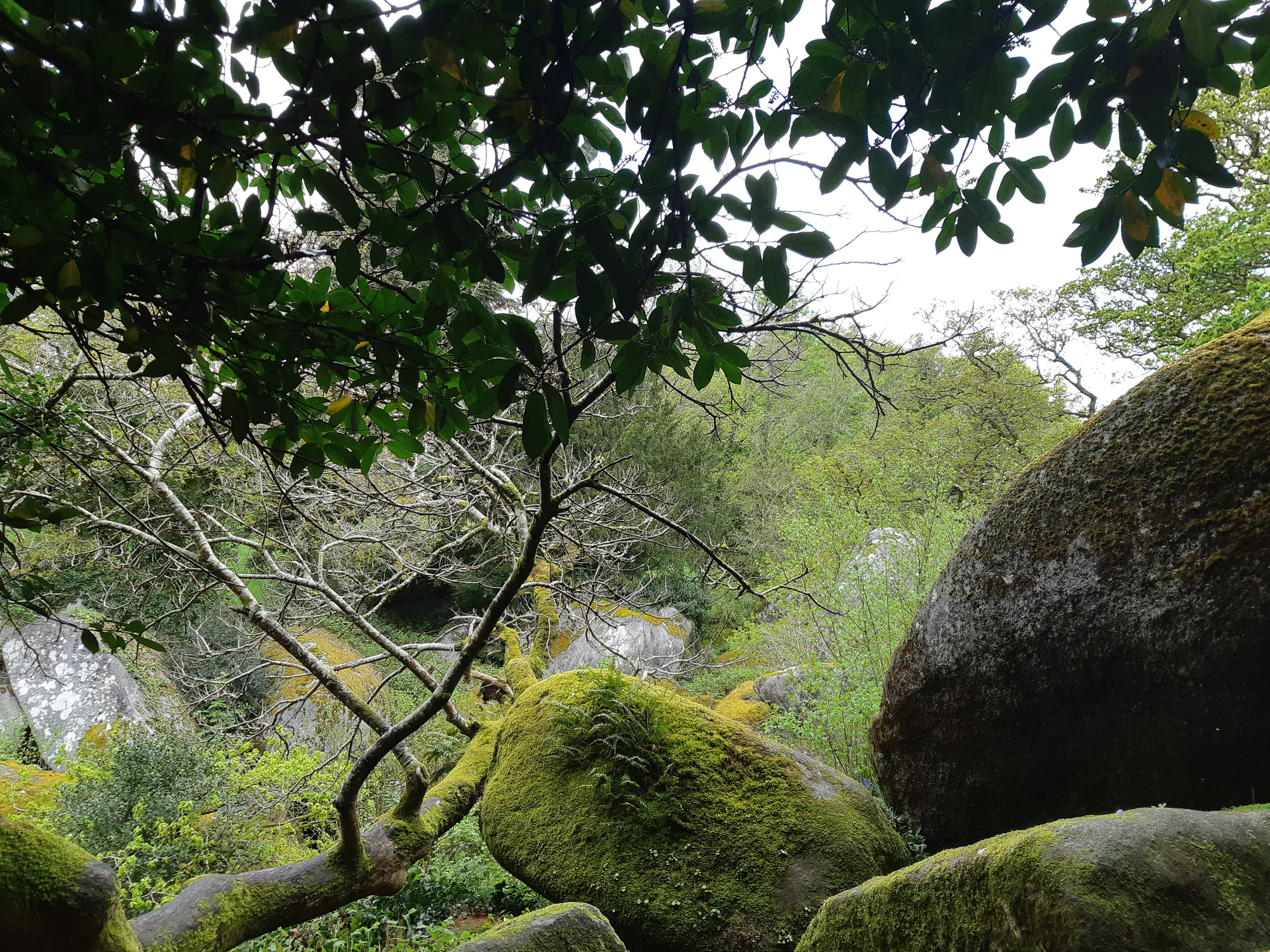
Rounded mossy boulders sit beneath branches and leafy woodland canopy.

Moss-covered granite in Huelgoat woodland, photographed in April 2019.

“Chaos granitique à Huelgoat” — Romain Cadiou, CC BY-SA 3.0. Source: https://www.geodiversite.net/media1829. License: https://creativecommons.org/licenses/by-sa/3.0/. Original photograph unchanged. · Creative Commons

Wildlife and habitats

Sessile oak

In Huelgoat, look at how trunks and roots fit around rock and shallow soil. The ONF identifies sessile oak in the forest. Studying a tree’s position can tell a richer story than hunting for the largest specimen; keep to the path and compare the shapes you can see.

Eurasian otter

The otter is part of Huelgoat’s river life, but a casual daytime sighting is a bonus. Give the banks space and enjoy watching the water from the path. A quiet stream is valuable habitat even when its most elusive resident stays out of sight.

Greater horseshoe bat

The park records this bat among Huelgoat’s forest fauna. Learn about it through the interpretation material or an organised nature outing. Mine galleries and other potential roosts are places to leave undisturbed, not destinations for a torch-lit search.

Marbled newt

The marbled newt is one of the amphibians documented here. Its presence is a reminder that woodland conservation also concerns wet places. Do not lift logs or stones to find one, and leave any animal you encounter exactly where it is.

Marsh fritillary

Mougau’s official visitor material names this butterfly among its wetland wildlife. On a suitable day, watch flowering vegetation from the boardwalk rather than stepping into it for a closer photograph. A butterfly moving out of reach is a reason to wait, not to follow.

Sundews

Mougau supports sundews, tiny carnivorous plants. The park explains how they obtain nutrients from insects in an acidic, nutrient-poor habitat. Use the panels to learn what to look for and stay on the walkway; no plant needs to be touched or fed to make this a memorable discovery.

Stories and discoveries

A boulder field is a geological history

Huelgoat’s granite began as molten rock underground. Weathering and erosion later exposed and shaped the blocks. The spectacular pile is therefore the visible result of a long sequence, rather than one moment when stones fell from the sky. The landscape is part of the Armorique UNESCO Global Geopark story.

The green coating matters

Huelgoat’s damp rocks support rare mosses and tiny protected ferns. Some of the most important plants are easily overlooked because they are small. A moss-covered boulder is a habitat, not simply a convenient climbing surface. Photograph its textures from the path without peeling or brushing the growth away.

Wet ground holds a long memory

In peatlands, plant material can accumulate without fully decomposing. The park highlights the role of sphagnum mosses in this process and the carbon stored in the resulting peat. At Mougau, the walkway lets you cross this sensitive setting while leaving the wet ground and its vegetation intact.

When to visit

Calm spring and summer days

Use Mougau’s opening season for a close look at wetland plants and interpretation. Huelgoat offers a different way to spend a warm day, with woodland and water rather than an exposed ridge. Pack for a change in weather, and check fire restrictions even when the setting looks green.

Autumn and winter decisions

Check Huelgoat’s ONF hunting calendar and notices on arrival. The published 2026–27 calendar is indicative and can change; signs on the ground still matter. In strong wind, postpone woodland walking. Outside Mougau’s May–October season, choose a different authorised outing instead of assuming the boardwalk remains available.

Getting there and practical advice

Use the town as your Huelgoat base

The Huelgoat tourist information office is at 25 Place Aristide Briand. Its walking page provides a forest map and links to guided visits. Check office hours before relying on a stop there, and settle food, drinking water and toilet needs in town before heading into the woods.

What to expect at Mougau

Use the parking area by the allée couverte at Mougau-Bihan. The adapted-route sheet marks picnic tables and resting supports. Bring your own provisions and confirm toilet options before heading out.

Reach Huelgoat by regional coach

Transdev lists BreizhGo line 960 between Morlaix, Huelgoat and Quimper, with a Huelgoat Bourg stop. Check the timetable for your actual date and both directions before making a car-free plan; school-day, weekend and seasonal patterns may differ. Use BreizhGo’s accessibility guidance if you need a wheelchair space or confirmation of an accessible stop.

Plan Mougau as a separate journey

Mougau-Bihan is in Commana. Set that site as your destination rather than the park’s administrative headquarters. If you are travelling without a car, arrange the onward journey before leaving Huelgoat; do not count on the Huelgoat coach for this separate leg.

Choose by surface, not by the word “easy”

Short distance does not remove roots, slopes or slippery stone. Huelgoat’s chaos terrain and Mougau’s raised decking are different access questions. Use the dedicated Mougau accessible sheet for the exact shortened outing, and ask about current conditions, assistance and nearby accessible toilets before travelling if any of those are essential.

Sources and useful links

Wildlife you might spot

6

Each card links to a full Explore page with photos, traits, and fun facts.

Snap map for this place

Start with the big picture, then zoom in to explore individual wildlife observations around this place.

Loading map…

Good to know before you go

Download the relevant route sheet before leaving; use on-site signs to choose between Mougau’s short circuit and the longer ridge walks.

Wear footwear with grip. Wet granite, roots and wooden decking deserve more care than the short distances suggest.

Keep dogs on a lead, stay on the marked path and leave flowers, mosses and dead wood where they are.

Carry a cold picnic and drinking water. Leave stoves, barbecues and smoking out of a forest or heathland visit.

At Huelgoat, check the current GR37 diversion near the Mare aux Fées before committing to a longer circuit.

Keep a return-time margin if travelling by bus. A service reaching Huelgoat does not provide a connection to every park trailhead.

Frequently asked questions

Choose the shorter Mougau return route if 2 km is too much. At Huelgoat, ask for a town-side outing matched to your group. Keep children close near the water and skip caves or scrambling: the boulders are impressive from the path.
No single day does justice to the inland hills, coast and islands. Choose Huelgoat or Mougau as your main stop. Treat Crozon and the Iroise islands as separate plans requiring their own weather, access and, for islands, boat arrangements.
The self-guided route information lists no booking requirement. For a guided outing, check the tourist office’s current programme, then confirm availability, price and meeting point with the organiser.
These are documented residents of Huelgoat’s forest habitats, not predictable daytime attractions. Enjoy the stream and woodland whether or not an animal appears. Never enter a roost or mine gallery, search under stones, or leave the path to pursue wildlife.

Recent snaps at this place

Recent snaps will appear here as new observations are added.

View all ›

Take the discovery with you

Exploring Armorique Regional Nature Park?

Identify the wildlife you spot, learn as you go, and keep a collection of the adventure.

  1. 1Spot it
  2. 2Snap it
  3. 3Keep the discovery