Snappit logo
Snappit
Get App
Generic illustration, not a photograph of this venueIllustration
ParkIT

Julian Prealps Nature Park

The pleasure here is in the change of scale: a path beneath leafy trees, water emerging from a mountainside, then the pale, broken rock of the high karst.

About

The pleasure here is in the change of scale: a path beneath leafy trees, water emerging from a mountainside, then the pale, broken rock of the high karst. The park protects portions of six municipalities, so there is no single entrance or sensible one-day circuit of everything. Pick a valley first and let the weather, daylight and your walking experience decide how far you go. Turn your visit into a safari! Use the Snappit app to scan and log wildlife sightings here.

The regional park and its managing body were formally established on 30 September 1996 under regional law 42/1996, after years of debate and early conservation work. Its villages have their own stories: Venzone was rebuilt after the 1976 earthquake, while Val Resia preserves a distinctive language and traditions. They reward time in their own right, rather than serving only as trailhead stops.

What to do here

For a first visit, choose Fontanone Barman for water and woodland, Pian dei Ciclamini for a gentler introduction, or Foran dal Mus for alpine geology. Read the route details below before choosing: a short nature trail and the Canin plateau make very different demands.

Seasonal info

October 2026 planning: the Prato di Resia visitor centre and park guesthouse are closed for works from 28 September 2026 through June 2027. The published 2026 Canin summer cableway calendar ended on 20 September. Arrange advice and accommodation before travelling, and do not plan an October walk around an assumed lift service.

Accessibility

Start by considering Sentiero per Tutti at Pian dei Ciclamini, designed with wheelchair-friendly gradients, wheel edging and a guide rope. Ask the refuge about the current surface, approach from parking and usable toilets for your needs. The other walks in this guide are not confirmed step-free.

Don't miss

1

A beechwood approach to the karst spring at Fontanone Barman

2

The accessible nature trail and longer woodland loop at Pian dei Ciclamini

3

Foran dal Mus

limestone shaped by water and ice

4

Resian village traditions alongside the mountain landscape

Walks and routes

Fontanone Barman: the short spring approach

Take the signed path from the parking area beyond Lischiazze. PromoTurismoFVG lists the linear approach as 0.8 km, about 20 minutes and 72 m of ascent; return along the same path, so allow roughly an hour for the outing and pauses. The broad woodland track narrows by the stream and the official roadbook ends near the first ford. Official route and directions.

A short walk does not make this an accessible walkway: narrowing terrain and wet rock call for secure footing. It is not presented here as wheelchair- or pushchair-accessible.
Fontanone Barman: the short spring approach

Sentiero per Tutti: a gentler woodland visit

Beside Rifugio Pian dei Ciclamini in Lusevera, this short woodland route introduces local nature through information panels. The refuge describes approximately 600 m; the regional tourism page gives about 700 m. Treat it as a short, unhurried visit rather than a precise distance challenge. Refuge route information.

The design includes wheel edging, a guide rope and tactile panels. Confirm surface condition and any assistance you need before setting out, particularly after storms. The accessible design may not meet every visitor’s needs without help.

Sentiero per Tutti: a gentler woodland visit

Percorso Fuori: woods and the idea of a border

For a fuller outing from Pian dei Ciclamini, follow the park’s approximately 6.5 km loop toward Passo di Tanamea, using CAI 719 on the outward section. Interpretation explores boundaries in nature and culture. The refuge describes the outing as about 7 km and three hours: allow extra time for reading panels and a picnic. Park route description.

This is a natural-surface walking route. Its easy walking description should not be read as a wheelchair-accessibility assessment.

Percorso Fuori: woods and the idea of a border

Foran dal Mus: the high-karst option

The park’s 2009 geological guide describes a short loop of about three hours with the Canin cableway and roughly 200 m of height difference, and a much longer loop of about eight hours with lift assistance. Without the initial lift it gives roughly five and ten hours respectively. These are published planning figures, not a current route clearance. Start the planning at Sella Nevea and read the official geological guide with a current map.

This is alpine walking across rough limestone, not an extension of the easy valley paths. Snow can hide holes and waymarks; cloud makes route-finding harder. The longer circuit’s Sentiero Sereno (CAI 645/a) includes exposed, partly equipped terrain. Choose the outing only with suitable experience, equipment and a stable forecast, or arrange a qualified guide.

Foran dal Mus: the high-karst option

Things to try

Keep a village or indoor alternative

If mountain weather turns poor, consider Venzone’s reconstructed historic centre or Val Resia’s cultural museums, checking individual opening arrangements first. The Prato di Resia visitor centre is unavailable during its announced works. From indoors, the park’s geology page and virtual tour offer a way to explore Foran dal Mus without committing to the mountain.

Wildlife and habitats

Look for habitats before animals

The park records Chamois, Alpine Ibex, Golden Eagle and Western Capercaillie among its wild fauna. Rock partridge, its emblem, is another characteristic bird. Watch from the path with binoculars; never play calls, approach nests or pursue an animal for a photograph. These are documented inhabitants, not a checklist you should expect to complete.

European Beech

The park’s botanical portal describes European Beech as very common throughout the park. On the Barman approach, the woodland itself is a rewarding subject: look at the canopy, fallen leaves and the contrast with bare limestone, without leaving the path.

Austrian Pine

Also known as black pine, this is a major part of the local woodland story. The botanical portal records Pinus nigra subsp. nigra as very common in the park. Its presence here should not be confused with planted black-pine landscapes elsewhere in the region.

Stories and discoveries

Water disappears, then returns

On the Musi, rain drains both over the surface and through underground cavities before reappearing at springs. Fontanone Barman is one of the striking results, with a series of falls totalling about 70 m. Up on Foran dal Mus, exposed karst and deep cavities reveal another part of that limestone story; glacial landforms add the imprint of ice.

A meeting place for plants

The park reports more than 1,250 plant taxa, counting species, subspecies and varieties rather than species alone. High rainfall, varied rock and the meeting of different floristic influences help explain the richness. Beech dominates the surveyed woodland, while black-pine woods and higher mountain habitats create a different feel within a relatively compact area.

When to visit

Spring and early summer

Enjoy lower woodland and fresh growth, but let snow reports decide any mountain plans. A snow-free car park does not establish a snow-free plateau. Give stream-side outings a miss when rain has made the water or footing unsafe.

Summer and autumn

Use the longer summer days for a properly planned high route. In autumn, shorter days favour a more modest itinerary and time in the woods. Check the dated lift calendar rather than assuming every weekend is served; refresh the forecast immediately before walking.

Winter

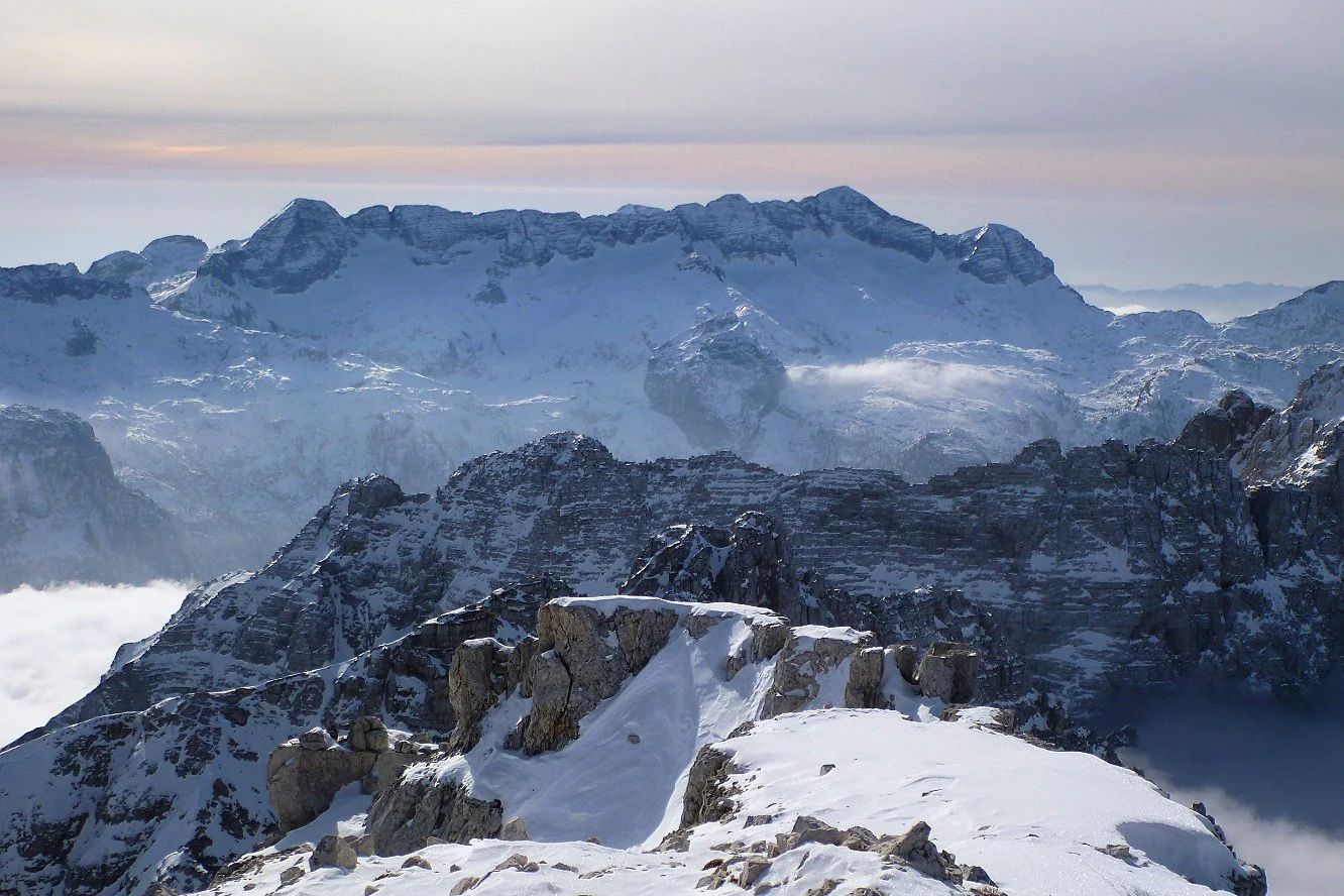
Treat snow-covered mountains as a different activity requiring winter skills, suitable equipment and avalanche information. The winter photograph in this guide is a landscape illustration, not a suggested walking line. Choose a lower alternative only after checking ice and access there too.

Snow covers a succession of jagged limestone ridges beneath a pale sky, with low cloud between the mountains.

The Canin massif under snow on 29 January 2012. This historical winter view shows the character of the high limestone landscape; it does not show present trail or snow conditions.

“Canin.jpg” — chripell from Friuli, Italy; Wikimedia Commons / original Flickr photograph; CC BY-SA 2.0; unchanged original, no modifications. · Creative Commons

Getting there and practical advice

Advice, food and overnight stays

For route advice during the Prato di Resia closure, contact the park at [email protected]. Book accommodation separately and check food service with the refuge or village business. The park also lists unstaffed mountain shelters: they are basic refuges, not a promise of meals, drinking water or an available bed.

Current bridge and path notices

The park’s 11 July 2026 update reopened the Resiutta–Resia cycling/walking connection using a temporary ford around the Ponte Tigo works; it did not announce the bridge itself reopened. Confirm the diversion before using it, especially after rain. Separately, the 9 July 2026 notice removed the works restrictions on Ta Lipa Pot. Check for newer notices before choosing either route.

Getting to the right valley

The A23 and SS13 corridor serves the western and northern gateways; Resiutta is the turn into Val Resia. For Pian dei Ciclamini, approach the Alta Val Torre via Tarcento and the Uccea road. Do not build a circular drive around Sella Carnizza without checking that mountain road. With public transport, begin by checking rail arrivals at Carnia, Venzone or Tarcento and then the exact onward bus, not just the nearest station.

Buses and return journeys

Use Tpl Fvg’s current timetables and journey planner for your travel date, destination hamlet and return. The winter timetable took effect on 14 September 2026. A village stop may still leave a long walk to the trailhead, so establish that final leg before committing to a car-free outing.

Sources and useful links

Wildlife you might spot

6

Each card links to a full Explore page with photos, traits, and fun facts.

Snap map for this place

Start with the big picture, then zoom in to explore individual wildlife observations around this place.

Loading map…

Good to know before you go

Carry a waterproof layer, sturdy footwear, drinking water and an offline topographic map; valley sunshine is a poor guide to conditions higher up.

Keep dogs on a lead throughout the protected area. Ask the organiser first if you want to join a guided walk with a dog.

Leave wildflowers in place. Use photographs and the park’s botanical identification portal to explore them.

Treat barriers and local signs as instructions, even when a downloaded route continues beyond them.

Frequently asked questions

General access to the park is free. Lifts, guided activities, accommodation and individual attractions are separate services; check their current prices and booking requirements.
Choose one area instead. A day split between several valleys can become mostly driving, and a lift-assisted mountain outing still needs substantial walking time. Keep a lower-level alternative ready if the plateau is in cloud.
Use the signed visitor route and stop at its indicated end near the first ford. Do not interpret photographs of the waterfall basin as permission to scramble upstream, cross fast water or enter the gorge.
No. The transboundary biosphere reserve recognised in 2024 covers a much wider Italian–Slovenian area. Triglav National Park is a separate protected area in Slovenia, and the Val Alba Nature Reserve is also a separate designation.
You may, but no route guarantees sightings. Bring binoculars, stay on paths and give animals space. A quiet walk through their habitat is worthwhile even when the animals remain out of view.

Recent snaps at this place

Recent snaps will appear here as new observations are added.

View all ›

Take the discovery with you

Exploring Julian Prealps Nature Park?

Identify the wildlife you spot, learn as you go, and keep a collection of the adventure.

  1. 1Spot it
  2. 2Snap it
  3. 3Keep the discovery