Snappit logo
Snappit
Get App
Generic illustration, not a photograph of this venueIllustration
ParkMainland, Spain

Monfragüe National Park

Monfragüe is a place to slow down and look up.

About

Monfragüe is a place to slow down and look up. Pale cliffs stand above the dark water of the Tajo, wooded slopes fold behind them, and a distant bird can suddenly give the whole landscape a sense of scale. The national park protects a mosaic of Mediterranean woodland, scrub, rocky ridges and rivers in the heart of Extremadura. Its famous birdlife is one reason to come; the contrast between open rock, dense vegetation and shaded streamside woodland is another.

Start in the small village of Villarreal de San Carlos. The reception centre helps you choose an outing that fits the weather and your group, while the nearby nature interpretation centre explains what you are about to see. Then put that introduction into practice: take the short Malvecino riverside section if conditions suit, and travel separately by road to Salto del Gitano for the cliff-and-river view. That combination makes a satisfying half-day without turning the visit into an endurance test.

Give each stop time. Spend a quiet few minutes listening beside the stream, compare the vegetation with the drier hillsides, and use binoculars at the public viewpoint. A good visit does not depend on ticking off rare birds. Enjoy whatever appears, keep your distance and leave the wildlife's space undisturbed. Unlock an interactive field guide for this spot: get the Snappit app to identify nature on the go.

Villarreal de San Carlos began as a practical response to a difficult journey. Carlos III founded the settlement to make the route between the Puerto de la Serrana and the Puente del Cardenal safer. It remained a small village linked to Serradilla. The surrounding landscape holds much older traces of people, including rock art, livestock routes and the repeatedly rebuilt medieval castle. The broad water surfaces you see today also tell a modern story. The Torrejón and Alcántara dams, built in the 1960s, changed the Tajo valley, while large-scale eucalyptus and pine planting altered parts of the woodland. Conservation campaigning helped secure natural-park status in 1979; national-park designation followed in 2007. Woodland restoration, including the removal of eucalyptus around Malvecino, is part of the landscape's continuing story.

What to do here

Begin with the Villarreal centres, choose either the short Malvecino walk or a centre-and-viewpoint visit, and finish with an unhurried stop at Salto del Gitano. Save the longer hill routes for a day when walking is the main plan.

Seasonal info

Summer heat and fire danger can change access; winter brings colder conditions and shorter afternoons. Some longer routes have conservation closures. Check the park and weather notices for your date, even when a route appears in a brochure.

Accessibility

The centres and the adapted Malvecino section offer useful options, but the approach to that section is separate from the flat riverside path. Ask staff about reserved-parking access, the current surface and the nature centre’s ramp and lift. Do not assume the full green route or every viewpoint is step-free.

Don't miss

1

Watch the sky above the river cliffs from Salto del Gitano.

2

Explore the compacted-earth, 500 m one-way adapted section beside Arroyo Malvecino.

3

Use the Villarreal interpretation centre to understand Mediterranean habitats.

4

Notice how rocky ridges, wooded slopes and the surrounding dehesas fit together.

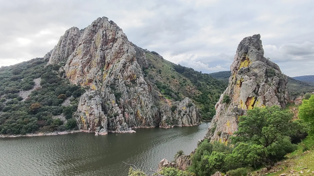
Steep pale rock faces and wooded slopes rise from dark water beneath a cloudy sky at Salto del Gitano.

The cliffs and water at Salto del Gitano in Monfragüe National Park, photographed in April 2025. This is wider-park context beyond Villarreal de San Carlos.

Salto del Gitano, Parque Nacional de Monfragüe (69623).jpg — Mentxuwiki / Wikimedia Commons / CC BY-SA 4.0 · Creative Commons

Walks and routes

Arroyo Malvecino: the short riverside section

The adapted path runs 500 m one way beside the seasonal stream, then returns the same way: 1 km altogether. Allow 30–45 minutes for this section with pauses. If you start at the car park at the entrance to Villarreal, add the published 800 m stone-paved approach in each direction, making about 2.6 km and roughly 60–90 minutes overall. Follow the signed short option rather than continuing around the full green route.

The park describes the riverside section as flat compacted earth, with guide posts and Braille information. The 800 m approach is a separate stone-paved track. Ask about access to the reserved parking at the adapted route’s start and about present surface conditions.


Arroyo Malvecino: the short riverside section

Salto del Gitano: a separate viewpoint stop

Travel from Villarreal by the public road to the designated Salto del Gitano viewpoint. Pause for the water, rock faces and open sky; give yourself about 20–40 minutes rather than making it a quick photograph from the car. This stop does not include a walk to the castle or an unsignposted riverside descent.

A road-accessed stop can reduce walking, but confirm the parking-to-viewpoint arrangement for your needs. Take care beside traffic and keep children close at the viewing edge.

Salto del Gitano: a separate viewpoint stop

Optional longer walk: Ruta Verde to Cerro Gimio

The park lists the full Arroyo de Malvecino–Cerro Gimio circuit as 7.9 km, with low difficulty. It explores a wider range of vegetation and is a different commitment from the adapted section. Allow about 3–4 hours including stops and ask staff which signed circuit to follow. Choose it instead of the short walk, not as an automatic add-on.

The full circuit is a countryside walk and should not be treated as an adapted wheelchair or pushchair route merely because it is graded low difficulty.

Optional longer walk: Ruta Verde to Cerro Gimio

A relaxed first half-day

Spend 30–45 minutes at Villarreal getting oriented and visiting the nature centre. Choose the short Malvecino outing, allowing for its approach, then take a break before driving to Salto del Gitano. Leave time simply to look. If someone is tired, omit the walk and keep the viewpoint stop; if the weather is poor, stay with the indoor visit.

Things to try

Try ten quiet minutes of birdwatching

Choose a safe place at a public viewpoint, find the horizon without binoculars first, then watch one bird rather than chasing every movement. Notice whether it circles, glides or flaps. A small notebook or a sketch can be more memorable than a distant phone photograph.

Make a family habitat challenge

Ask everyone to find three different textures or shapes from the path: a jagged ridge, a rounded tree canopy and a leaf beside the stream. Compare the shaded Malvecino corridor with the open rock at Salto del Gitano. Look and sketch rather than collecting anything.

Join a park-led activity when it fits

The free Conecta con Monfragüe programme offers interpreted walks and viewpoint birdwatching, normally in March–June and October. Places need advance booking. Check the current monthly offer and participation conditions through the official itinerary page or ask Villarreal; weather and conservation needs can change the programme.

Use a wet day for the indoor introduction

Keep the nature centre as the main visit if rain or strong wind makes outdoor stops unpleasant. Check its midday break, then ask staff whether any short route is suitable. Avoid exposed viewpoints in thunderstorms and do not press on beside a swollen stream just to finish an itinerary.

Wildlife and habitats

Griffon vulture

Watch a soaring bird for a while: long glides and circling flight are part of the attraction. Use binoculars from the public viewpoint and keep attention on the bird rather than trying to find its nest.

Cinereous vulture

The park also supports this large woodland-associated vulture. Compare any distant bird with the park’s bird profiles or ask a guide to help; a dark silhouette alone is not a secure identification.

Black stork

A shy waterside bird to learn about before your visit. Keep any observation distant and quiet; do not leave a path to look for feeding or breeding places. Many leave for Africa towards the end of summer.

Egyptian vulture

The adult’s pale-and-dark wing pattern and wedge-shaped tail are useful starting clues. This smaller vulture is a seasonal visitor; learning its shape beforehand makes any encounter more rewarding.

Red deer

In early autumn, listen for the rut from a public path or viewpoint. If a deer is nearby, give it room; never follow it into the vegetation or stop unsafely on the road.

Strawberry tree

Use the park’s plant guide to learn the Spanish name madroño, then compare plants from the path. Look without picking leaves or fruit; the park’s plants are part of the habitat.

Black alder

Look at the leafy streamside vegetation around Malvecino and compare it with the drier hillsides. Alders help make that narrow corridor feel different, even when the seasonal stream carries little water.

Oaks

Several kinds of oak help shape Monfragüe. Look for differences in bark, leaves and tree form from the path, using the park’s plant guide to distinguish them. This oak entry covers the genus rather than identifying every tree to species.

Stories and discoveries

The ridges are a geology lesson

Hard quartzite resists erosion better than neighbouring softer rocks. That contrast helps explain the repeated ridges and valleys you see across Monfragüe. You do not need to climb a summit to start noticing the pattern.

Dehesa is a working landscape

The open oak-dotted pasture around Monfragüe has been shaped by people and livestock. It supports farming and wildlife together, and provides feeding habitat for birds that use the park’s woodland and cliffs.

One name, different protected areas

The national park is 18,396 hectares. The UNESCO biosphere reserve, recognised in 2003, covers a much wider surrounding landscape. A tourism attraction described as “Monfragüe” may therefore be outside the national-park boundary.

When to visit

Spring

A good season for a longer look at the park’s plants and birds. Black storks and Egyptian vultures are seasonal breeding visitors; watch from public places and give any sensitive or restricted area plenty of space.

Summer

Keep walks short in the heat and carry sufficient water. Shade beside a stream does not make a hot day safe for a long circuit. Check fire and access instructions before setting out, and choose indoor interpretation or postpone the walk if conditions are unsuitable.

Autumn and winter

Early autumn is the red deer rutting season; listen from public areas rather than approaching animals. Later in the year, plan for cold, rain and shorter daylight. Black storks and Egyptian vultures should not be treated as year-round targets.

Access and seasonal restrictions

Planning information was checked on 16 October 2026. The Junta announced that the 2026 high-fire-danger season would end on 15 October, but park fire rules and local closures still apply. Longer reserve-zone itineraries need separate checks: the brown-route booking description excludes tourist permits from 1 February to 15 September. Confirm the current rules and any closures with Villarreal for your visit.

Getting there and practical advice

Villarreal reception centre

The published reception hours are 09:30–19:00 in summer and 09:30–18:00 in winter, daily except 24, 25 and 31 December and 1 January. Telephone +34 927 199 134; email [email protected]. Ask which seasonal timetable applies, and contact the centre ahead for an organised group.

Nature interpretation centre

Admission is free. Published hours are 09:30–14:30 and 15:30–19:00 in summer, or until 18:00 in winter. It closes on 24, 25 and 31 December and 1 and 6 January. Its displays introduce the park’s natural and cultural setting. Check opening changes with reception before travelling.

Food, water, toilets and breaks

Bring the water and snacks you need for your walk and check meal options before relying on them. Ask at Villarreal where to use toilets before leaving the village. The official accessible-visit leaflet identifies a covered picnic-viewpoint at Puente del Cardenal, reached by the old road; ask staff about current access if you need a planned resting stop.

What to budget

The park’s basic public facilities are free, including the nature centre. Budget separately for travel, meals, accommodation and any commercial tour. Some complementary services can charge, so check the operator’s current price before booking.

Arriving and moving between stops

Villarreal de San Carlos is reached on the EX-208 between Plasencia and Torrejón el Rubio. A car or prearranged transfer makes it easier to combine the village with Salto del Gitano. Use the official access page for your approach, stay on public authorised roads and park only where designated.

If you are travelling without a car

The park’s access page mentions a Monday–Friday service between Plasencia, Villarreal and Torrejón el Rubio, but gives no timetable. Confirm the actual outward and return journeys with the bus station or operator before committing; Plasencia bus station is listed at +34 927 414 550. Do not assume a weekend service or that the bus links every viewpoint.

Choose the building and route that suit you

The official access leaflet describes a street-level reception entrance. At the nature centre it describes a fitted ramp over the entrance step, a lift to the upper room and some Braille panels. Ask staff whether the ramp and lift are available and which toilets and resting places will suit your needs.

Keep the short path genuinely short

For the adapted Malvecino section, discuss the reserved-parking approach before arriving. If you use the village car park, the extra stone-paved access is part of your outing. For a pushchair, wheelchair or limited walking range, decide on that basis rather than the 500 m figure alone.

Sources and useful links

Wildlife you might spot

8

Each card links to a full Explore page with photos, traits, and fun facts.

Snap map for this place

Start with the big picture, then zoom in to explore individual wildlife observations around this place.

Loading map…

Good to know before you go

Call the Villarreal reception centre on +34 927 199 134 before travelling if access, opening hours or mobility arrangements are important to your visit.

Carry drinking water, a snack, sun protection and shoes with grip. Add a warm or waterproof layer when the forecast calls for it.

Bring binoculars if you have them. Watch quietly from public paths and viewpoints; do not feed wildlife, play bird calls or approach nests.

Park only in designated places. Keep children close beside the EX-208 and at viewpoint edges, and never stop in the road to watch an animal.

Keep dogs on a lead and under control. Check individual buildings’ arrangements before bringing a dog inside.

Do not light fires, swim, boat or fly a recreational drone in the park. Take all litter away and leave plants, rocks and other natural objects where they are.

For longer walks, confirm whether a permit is required and carry it when applicable. A route listing or permit does not override a closure.

Save the official route information before setting out, tell someone your walking plan and allow time to return. Mobile coverage can be limited; call 112 in an emergency.

Frequently asked questions

No. It is the starting point for this visit. The national park covers 18,396 hectares across seven municipalities; Salto del Gitano and the other public-use sites are separate stops within it.
The park’s basic visitor facilities are free, and the nature interpretation centre is free to visit. You can make the suggested public-use visit independently. Guided programmes require booking, and some longer reserve-zone routes need permits. Commercial guiding, transport and meals are separate costs.
The adapted riverside section is 500 m each way, or 1 km out and back. From the village-edge car park, the published approach adds 800 m each way, making about 2.6 km in total. Visitors entitled to use the reserved parking should arrange access with staff.
Wildlife decides its own timetable. The public viewpoints are good places to observe patiently, but species, numbers and distance vary. Make the landscape and the short walk part of the pleasure too.
You can make a longer day of Monfragüe, but choose deliberately. The castle involves an uphill approach and steps, and the full red route is a separate 16 km walking option. Do not turn a gentle first visit into a long hike by accident.
Swimming and recreational boating are prohibited, and overnight stays outside authorised accommodation are not allowed. Arrange suitable accommodation and treat the reservoirs as scenery rather than bathing places.

Recent snaps at this place

Recent snaps will appear here as new observations are added.

View all ›

Take the discovery with you

Exploring Monfragüe National Park?

Identify the wildlife you spot, learn as you go, and keep a collection of the adventure.

  1. 1Spot it
  2. 2Snap it
  3. 3Keep the discovery