Snappit logo
Snappit
Get App
Generic illustration, not a photograph of this venueIllustration
ParkIT

Puez–Odle Nature Park

Come for the Odle skyline, then give the landscape a little more time.

About

Come for the Odle skyline, then give the landscape a little more time. From Zannes in Val di Funes, woodland and working pastures bring you close to the foot of the cliffs. From Selva di Val Gardena, Vallunga draws you between steep walls before the harder climb towards Puez. These are different days out, with different levels of effort. You can enjoy the park without taking a lift or tackling a summit; the most useful first decision is whether you want an interpretive stroll, a proper mountain walk or a high-alpine day. Explore the grounds like a pro—download the Snappit app to instantly identify animals and plants.

The provincial nature park was established in 1978 and enlarged in 1999. It now covers about 10,729 hectares within seven South Tyrolean municipalities. The Dolomites received UNESCO World Heritage recognition in 2009; the nature park and the wider World Heritage property are related designations, with their own boundaries.

What to do here

Choose Zannes for a short nature trail or the longer Adolf Munkel loop below the Odle. Choose Vallunga for a valley-floor out-and-back, and reserve the Puez circuit for fit walkers comfortable with sustained ascent and descent. Start with the park visitor centre if you want the rocks and landforms to make more sense.

Seasonal info

Snow, ice and poor visibility can change a manageable summer path into a mountain problem. Short autumn days matter on the return as much as on the ascent. In winter, choose a separately maintained winter route and check local advice; do not follow these summer descriptions across snow.

Accessibility

Zannes is the park’s principal adapted nature trail, with rest areas and some Braille interpretation. Its approach and slopes need a more careful check than the word “accessible” suggests. The detailed accessibility section below explains the conflicting published gradient figures.

Don't miss

1

Walk below the Odle without committing to a summit.

2

See how valley woodland changes into alpine pasture and bare rock.

3

Compare a gentle valley outing with a demanding climb to Puez.

4

Use the visitor centre to turn a striking view into a geological story.

Walks and routes

Zannes nature trail: the short introduction

This approximately 3 km circuit starts and ends at the Zannes car park. It passes meadows, woodland and a former lime kiln, with interpretation and places to stop along the way. Allow roughly 60–90 minutes to pause and read, rather than treating it as an exercise lap. It is a good choice when you want the cliffs in the background and small discoveries close at hand. Official nature-trail description.

An adapted trail, but not a flat promenade. Check the detailed gradient and arrival notes below before bringing a wheelchair or pushchair.
Zannes nature trail: the short introduction

Adolf Munkel: the 9 km return to Zannes

From Zannes, take trail 6 towards Ciancenon/Tschantschenon, then trail 35 beneath the Odle. For the shorter circuit, continue to the Casnago and Geisler pastures and return on trail 36 via Malga Dusler. The official description gives 9 km and 3 hours of walking; allow longer for lunch and stops. This is the choice for close-up cliffs combined with forest and meadow scenery. Official route and variants.

Expect uneven mountain paths rather than the graded surfaces of the adapted nature trail. Take footwear with good grip and allow time for the return.

Adolf Munkel: the 9 km return to Zannes

Vallunga: stay in the valley

From the entrance near Selva, follow trail 14 past the chapel of San Silvestro. The route gradually rises through trees and opens into pasture between steep walls; return the same way. The published outing is 7.5 km, 201 m ascent and about 2 hours walking. An earlier turnaround gives a shorter visit without committing to a circuit. Official Vallunga walk.

The operator rates this easy and suitable for pushchairs, but it still climbs and uses an outdoor surface. A pushchair-friendly label does not establish independent wheelchair access.

Vallunga: stay in the valley

Vallunga to Rifugio Puez: a full mountain day

The official circuit follows trail 14 up Vallunga, continues to Rifugio Puez at 2,475 m, then returns by trails 2 and 16 to the valley approach. It is rated difficult: 13 km, 895 m ascent and 5 hours walking. Start early and reserve a full day, including pauses and a margin for the descent. The reward is the change from enclosed valley to open, rocky high ground. Official Puez circuit.

For fit, sure-footed mountain walkers with navigation skills and appropriate equipment. This is not the easy Vallunga outing continued for a few extra minutes.

Vallunga to Rifugio Puez: a full mountain day

Things to try

Watch quietly and leave things in place

Use binoculars from the path and let wildlife decide the distance. The park’s published rules prohibit picking plants, leaving rubbish and ordinary tent camping; mineral and fossil collection requires special authorization for scientific or educational purposes. Keep dogs closely controlled, preferably on a lead. Follow marked routes and local restrictions, including any cycling limits. As checked on 19 October 2026, an official Val Gardena long-distance route page still warns that Forcella Pana is closed; do not use it as an improvised connection between the Odle sides.

When walking is the wrong plan

Choose the Santa Maddalena visitor centre when it is open, rather than climbing higher in the hope of finding a view. Its geology displays are particularly helpful before a later walk. For a short dry interval, an out-and-back lets you turn around early, but heavy rain, thunderstorms, ice or an official warning are reasons to abandon the outdoor plan altogether. Check opening hours before travelling specifically for an indoor visit.

Wildlife and habitats

Chamois

Chamois use the park’s mix of mountain pine and grassy slopes. Their habitat connects the rocky skyline with the vegetation beneath it.

Alpine marmot

Alpine pastures provide habitat for marmots. Their presence is one reason to leave open ground undisturbed; stay well away from burrows.

Golden eagle

Golden eagles range over the park’s ridges and valleys. A distant bird above the cliffs is a possibility, never a promised encounter.

Rock ptarmigan

Rock ptarmigan live year-round on the high plateaux. Keep to the route through this exposed habitat and give any birds plenty of room.

Western capercaillie

Western capercaillie belongs to the forest rather than the bare skyline. Its woodland habitat deserves quiet; avoid seeking display grounds or following calls.

Norway spruce

Norway spruce is part of the park’s woodland, including the open forest of Vallunga. The woods frame the cliffs on the lower walk.

Larch

Larch shares Vallunga’s open forest with spruce and stone pine. These mixed woods give the valley a different character from the Puez plateau.

Stories and discoveries

Why the scenery changes so sharply

The park preserves a long sequence of volcanic, desert and marine rocks. The red-brown rocks of Rasciesa recall ancient eruptions; Val Gardena Sandstone records an arid landscape before the sea advanced. Later marine deposits helped build the cliffs now dominating the skyline. Faulting complicates that sequence: on Puez, older rock has been pushed above younger layers. You do not need to identify every formation to enjoy the contrast between sheer walls, softer slopes and the stony plateau.

Meadows are part of the story too

This is also a worked landscape. High mountain meadows, including those around Sas de Pütia, are still cut for hay. Forest, dwarf shrubs, scree and pasture support different communities within a relatively short change in height. Look across those transitions rather than treating everything green as the same habitat. Flowers belong where they grow: enjoy them without picking them or stepping off the path for a closer photograph.

When to visit

Match the day to the conditions

For a first summer visit, choose the shorter walk you can finish comfortably and leave time for interpretation or a meal. For a high route, compare the mountain forecast’s visibility, wind and precipitation with your ability and escape options. If cloud is closing in, an open plateau is a poor place to discover that navigation is difficult. In autumn, set a turnaround time that leaves daylight for the descent. In snow season, use current winter-route advice and the avalanche bulletin; equipment alone does not make a summer itinerary suitable.

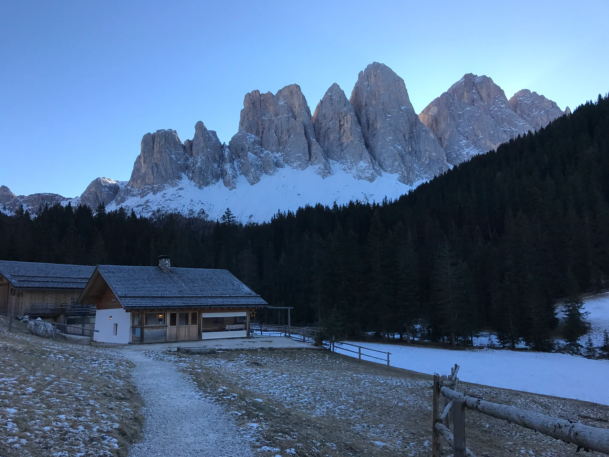
Pale jagged mountain walls above dark conifer woodland, with snow patches, a path, fences and small buildings in the foreground.

A winter view in Puez–Odle Nature Park, photographed on 29 December 2016. Snow below the cliffs is a reminder that the season changes the walking conditions; this historical photograph does not show conditions today.

File:Puez-Odle.jpg — AntonioIaccheo / Wikimedia Commons — CC BY-SA 4.0. Unmodified original. · Creative Commons

Getting there and practical advice

Visitor centre in Santa Maddalena

At Trebich 1, the park visitor centre offers rocks, landscape interpretation, natural-history displays and films. It makes a useful first stop, especially with children. The published 2026 season runs 5 May–31 October, Tuesday–Saturday, 09:30–12:30 and 14:30–18:00; last admission is 17:30. Entry is free. It closes on public holidays except 15 August. Check the centre’s own page for your date.

Zannes infopoint

The free UNESCO infopoint beside the Zannes car park introduces the Dolomites’ geological development. For 2026 it lists 24 April–8 November, 09:30–18:00, closed Mondays and Friday afternoons from 12:30. Do not assume it follows the village visitor centre’s timetable. Infopoint information.

Food, water and an overnight at Puez

Treat mountain refreshments as seasonal and carry what you need until an opening is confirmed. For an overnight at Rifugio Puez, book through the hut’s website; its current rules require online reservations by midnight before arrival, with later enquiries by phone. Bring a sleeping-bag liner and your own slippers. The hut recommends cash because electronic payment depends on an unreliable connection. Check opening dates, availability and cancellation terms before committing. Puez booking information.

Getting to Zannes without a car

Use the railway to Bressanone/Brixen and check bus 330 towards Val di Funes and Zannes. Not every departure reaches the head of the valley: the 2026 timetable gives seasonal operating periods for the Zannes extension, including 26 April–8 November. Search your actual date and both directions in südtirolmobil, keeping the stop name Malga Zannes/Zanser Alm in mind. For the visitor centre in Santa Maddalena, the park identifies Vergin as the nearby bus stop.

Driving and parking

Zannes has limited paid parking. A traffic light near Santa Maddalena/Ranui signals capacity, and access may close when it is full. A limited car-space allocation can be reserved through the official parking page; coach reservations are mandatory. Check the current price and conditions there. If you are considering the northern Passo delle Erbe approach, remember that roads from Funes and Luson are narrow and have winter closures. It is not a dependable year-round shortcut between the valleys.

Reaching Vallunga from Selva

Local bus 357 serves Vallunga/Langental from Selva, with different summer, shoulder-season and winter schedules. The published autumn 2026 service is much thinner than the summer one, so plan the return before choosing your departure. Paid parking is available at the valley entrance. The routes described here begin there; walking from your accommodation adds distance. Check current timetables.

Zannes: check the approach, not just the trail label

The park describes an adapted nature trail with a maximum gradient of 8%. A separate UNESCO/independent.it access survey, revised in July 2019, measured an approach section at 12–14% and some trail stretches around 10%; it recommends rough-terrain equipment and assistance. Those descriptions are not interchangeable. The older survey also records accessible toilets at the Zannes infopoint and refreshment facilities. Before travelling, ask Odles tourism on +39 0472 840180 about the approach you will use, current surface, assistance, parking and toilet availability. Braille appears at some interpretive stations; this does not mean every sign or section is independently navigable.

Sources and useful links

Wildlife you might spot

7

Each card links to a full Explore page with photos, traits, and fun facts.

Snap map for this place

Start with the big picture, then zoom in to explore individual wildlife observations around this place.

Loading map…

Good to know before you go

Save the return bus options before walking; do not build the day around the last possible departure.

Carry water, food, a waterproof layer and warm clothing even when the valley feels mild.

Download an official route description and carry suitable navigation; a photograph is not a route map.

For a mixed-ability group, choose the day around the least confident walker and agree an early turnaround point.

Stay on marked paths, give grazing animals room and close gates as you found them.

Frequently asked questions

For the classic view from beneath the Odle, start at Zannes. If you are already staying in Selva, Vallunga offers a straightforward introduction without crossing to another valley. Choose one side for the day rather than spending the best walking hours driving between them.
The Zannes trail was designed with adapted access in mind, but gradients and the approach require individual assessment. Vallunga is labelled pushchair-friendly by its tourism operator; that is not a wheelchair-accessibility audit. Ask about current surface condition and equipment before setting out.
Zannes has a limited advance-bookable car-parking allocation; coach reservations are mandatory. Reserve an overnight stay at Rifugio Puez through its own website. A parking or hut booking does not confirm that the route is safe or open.
Keep dogs closely controlled and on a lead to protect wildlife and livestock. Rifugio Puez does not accept animals overnight. Tent camping is generally prohibited in the nature parks; the emergency alpine-bivouac exception is not permission to plan a camping holiday.
Possibly, but none is guaranteed. These are animals and trees documented for the park, not a record of sightings on your chosen walk. Quiet observation from the path is worthwhile; following animals, approaching burrows or searching for nesting and display sites is not.

Recent snaps at this place

Recent snaps will appear here as new observations are added.

View all ›

Take the discovery with you

Exploring Puez–Odle Nature Park?

Identify the wildlife you spot, learn as you go, and keep a collection of the adventure.

  1. 1Spot it
  2. 2Snap it
  3. 3Keep the discovery