
Snappit logo
Snappit
Get App
Generic illustration, not a photograph of this venueIllustration
ParkIT

Etna Regional Park

The regional park covers roughly 59,000 hectares on eastern Sicily’s volcano.

About

The regional park covers roughly 59,000 hectares on eastern Sicily’s volcano. Its scenery shifts from cultivated slopes and woodland to open lava and high volcanic ground. The UNESCO World Heritage property protects a smaller, high-altitude part of this larger park; the two boundaries are not interchangeable. For a first visit, the south offers the Monte Vetore area and the established Rifugio Sapienza tourist base. The northeast offers the Monti Sartorius landscape near Citelli, provided its approach roads and trails are confirmed accessible. Nicolosi’s Germoplasma collection is the lower-elevation choice when a mountain walk is too much. [Park overview](https://parcoetna.it/il-parco/) and [UNESCO property](https://whc.unesco.org/en/list/1427/). Enhance your adventure: download the Snappit app to identify the local species you encounter.

The park was established in 1987, becoming Sicily’s first regional park. UNESCO inscribed Mount Etna in 2013 for its outstanding volcanic geology. The volcano has a record of documented activity stretching back at least 2,700 years, but the landscape is not simply a monument to the past: landforms continue to change. The 1865 Monti Sartorius cones offer a particularly readable historical chapter, named for the geologist and cartographer Wolfgang Sartorius von Waltershausen.

What to do here

Pick a woodland-and-lava walk, pause to look closely at the volcanic rock, or explore cultivated Etnean plants at the Germoplasma collection. Treat high-altitude excursions as a separate, conditional activity to arrange with an appropriately qualified alpine or volcanological guide. A cable-car ticket or an attractive photograph does not establish permission to enter a restricted area.

Seasonal info

Autumn can bring golden birch foliage around Monti Sartorius, while pine woods keep their green backdrop. On the upper slopes, wind and cloud can make conditions feel far colder than on the coast. Snow, ice or poor visibility turn familiar summer paths into a different undertaking; do not treat a short distance or an “easy” rating as a winter assessment.

Accessibility

For mobility-aid users, start by asking the park about the Sentiero del Germoplasma beside its Nicolosi headquarters. Its published design includes a suitable surface and gradients below 7%. The lava trails described here have uneven or loose ground and are not verified step-free routes. Check the approach, gates, surface condition, toilets and assistance before travelling.

Don't miss

1

Pine woods and lava formations around Monte Nero degli Zappini

2

The 1865 cones and birch woodland of Monti Sartorius

3

Etnean plant diversity at the Germoplasma collection

4

A longer journey across the western and northern flanks on the Pista Altomontana

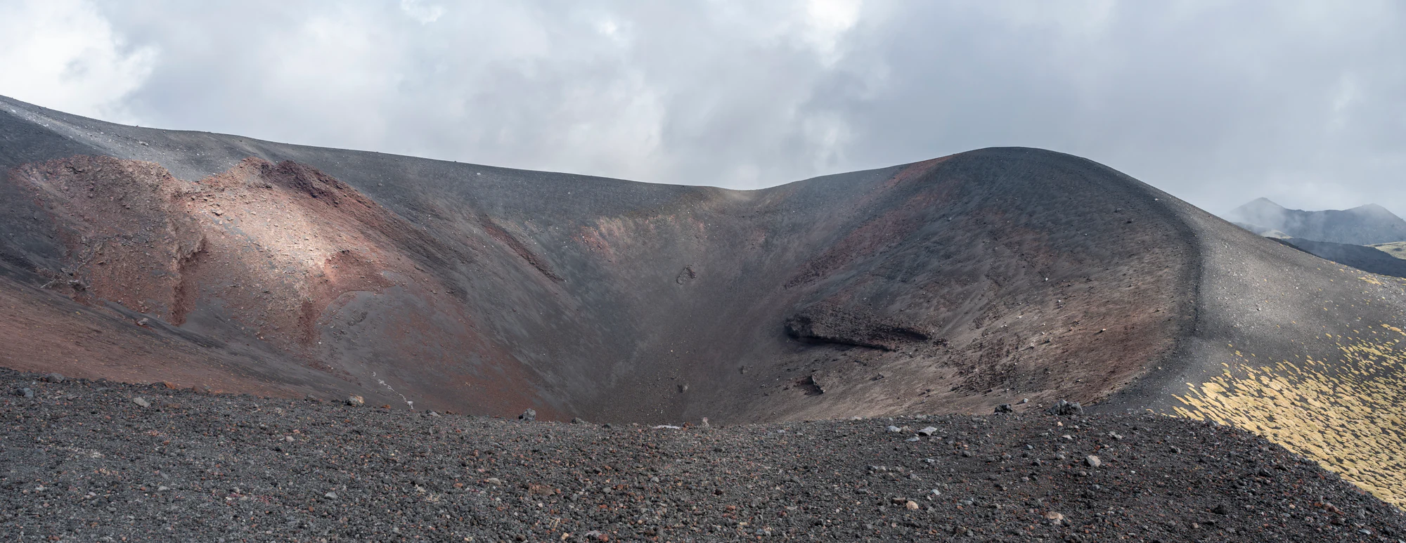
A broad crater of dark grey and reddish volcanic rock beneath low cloud, with sparse pale vegetation along the right-hand rim.

A secondary crater on Mount Etna, photographed in September 2024. The source does not name the crater; this historical image does not show current volcanic or access conditions.

“Mount Etna 2024 26.jpg” — Cayambe, via Wikimedia Commons. CC BY 4.0. Unmodified offered original. · Creative Commons

Walks and routes

Monte Nero degli Zappini: woods and lava on the south side

From the plateau west of Monte Vetore, this circuit crosses lava and woodland, with volcanic features such as hornitos and casts left around tree trunks. The park’s route 782 page lists 3 km and one hour. An older official sheet describes a 4 km nature circuit taking about 2½ hours: confirm the marked variant at the start rather than combining the figures. Give yourself extra time for the observation stops. The route reaches the Nuova Gussonea botanical-garden area; entry to the garden is a separate arrangement.

Rated low difficulty/T in the portal. Expect natural volcanic surfaces; this is not a wheelchair-accessibility assessment. Piano Vetore is the named parking area.


Monte Nero degli Zappini: woods and lava on the south side

Monti Sartorius: birches and the 1865 cones

This northeast-side loop starts at the forest barrier near Rifugio Citelli, at about 1,660 m. The park describes approximately 4 km and two hours, with six observation points among birches, volcanic bombs and the lava of 1865. The aligned small cones make this a rewarding place to understand a flank eruption without setting out for the summit. Use the official nature-trail description, and choose this outing only after confirming its approach roads and current trail access.

The published rating is easy, but sharp-edged lava and uneven blocks require secure footing. No step-free circuit is verified.

Monti Sartorius: birches and the 1865 cones

Sentiero del Germoplasma: a gentler visit in Nicolosi

Beside the park headquarters, the plant collection conserves Etnean genetic diversity, including local agricultural varieties, aromatic plants and trees. Its 1,153 m trail is a useful alternative when you want a shorter outing with more interpretation and less mountain terrain. The park suggests about an hour. Here, plants are grown together for conservation and learning, giving you a close look at local agricultural varieties as well as wild plants cultivated in the collection. Official trail details.

The published design has gradients below 7%, a surface intended for mobility aids and Braille interpretation. Ask about current surface condition, any locked entrance, accessible toilets and the approach from your drop-off point.

Sentiero del Germoplasma: a gentler visit in Nicolosi

Pista Altomontana: a separate multi-day project

The park’s route 701 description runs roughly 42 km from the Feliciusa Milia forest gate to Caserma Pitarrone in the Linguaglossa pine-forest area, along the western and northern flanks. Although often spoken of as a tour around Etna, these published endpoints do not form a complete closed circuit. The official estimate is about three days, with medium-to-high difficulty. Plan transport at both ends, water and overnight arrangements before committing. Official route description.

A substantial mountain outing, not an extension to a short nature walk. The source’s roughly 300 m elevation-difference figure must not be read as total climbing across 42 km.

Pista Altomontana: a separate multi-day project

A flexible first day

Start with the access and weather check, then make Monte Nero degli Zappini your main outing if conditions permit. Keep the rest of the day loose enough for lunch and a slow return rather than booking a second mountain objective. If the trail is unsuitable, ask about the Germoplasma collection in Nicolosi before setting off. For a second day, consider Sartorius only after its road access has been confirmed; it need not be squeezed into the same day.

Things to try

Take time over the rock

A short walk can hold plenty of interest. Compare the rough surface of a lava field with the shape of a volcanic bomb or a cone, using the trail’s interpretation points to put names to what you see. You do not need to leave the path or collect a sample to bring home a better understanding of the volcano.

If you want to go higher

Ask an authorized alpine or volcanological guide what itinerary is permitted and suitable for you that day. Discuss the walking involved, protective equipment, weather, cancellation conditions and what happens if the destination changes. Funivia dell’Etna sells different cable-car and transport/guide products, but availability must be checked for the exact service; one online “TOUR” product was unavailable for purchase at the time of review.

Linguaglossa visitor centre

The park’s visitor centre at Piazza Annunziata 5 in Linguaglossa has natural-history collections and educational displays. It can be a useful change of plan when mountain walking is unsuitable; confirm the day’s opening with the centre before travelling. A visitor-centre visit is a better fallback than continuing onto exposed terrain in poor visibility or thunderstorms. Visitor-centre information.

Wildlife and habitats

Wildlife belongs to the wider landscape

The park records red fox, European wildcat and peregrine falcon among its wild fauna. Treat a sighting as a bonus, not the purpose of approaching an animal. Wildcat conservation is especially important here, but an ordinary walk is not a reliable way to see one. Quiet observation from an existing path is more appropriate than seeking out dens or nests.

The plants explain the mountain

Lava age, altitude and exposure help shape Etna’s patchwork of vegetation. Around Sartorius, the park identifies the local birch as Betula aetnensis and also names the spiny cushion-forming Astragalus siculus. Beech occurs in the mountain woodland. Look at how plants occupy cracks and older surfaces, and photograph them without trampling the small islands of vegetation.

Stories and discoveries

A name rooted in the woodland

“Zappini” comes from the Sicilian term for pines. The Monte Nero nature trail was created in 1991, making the woodland itself part of the story rather than merely the scenery on the way to a crater.

When to visit

Leave yourself a weather alternative

Book a mountain day with some flexibility if you can. In spring, check for lingering snow; in summer, plan for exposed sun and carry sufficient water; in autumn, enjoy woodland colour without overlooking shorter daylight. A winter visit needs its own equipment and conditions assessment. Do not simply reuse a summer itinerary because a cable car or road happens to be operating.

Getting there and practical advice

Food, information and garden visits

Rifugio Sapienza is a developed south-side base with a hotel and restaurant; check service times directly. For park information and Germoplasma access, contact the headquarters at Via del Convento 45, Nicolosi, on +39 095 821111. Carry your own water and food for a trail rather than counting on a shelter. Nuova Gussonea is a separate botanical collection: an institutional listing describes visits by reservation, so confirm arrangements before treating it as an open stop.

Choose the side before arranging transport

Use Nicolosi and Rifugio Sapienza for the south-side tourist base; Linguaglossa, Milo and Sant’Alfio serve different northeastern approaches. Do not enter “Etna” as a destination and assume you will arrive at your trailhead. A car or arranged transfer is more flexible for walks away from the main tourist base, but road closures still take precedence over navigation instructions. AST advertises a Catania–Rifugio Sapienza bus connection. Verify the current departure point, return service, ticket arrangements and disruption notices with AST; a current complete timetable was not verified here. The bus should not be assumed to serve Monte Vetore or Citelli.

Ask about the whole journey

A manageable path is only one part of an accessible visit. Explain your mobility equipment and assistance needs when arranging transport or a guided experience, and ask about boarding, transfers, the walking surface at the destination and toilets. Broad operator claims about accessibility do not establish that every component will work for you.

Visitor information

Check access before choosing the day’s walk

Rules checked on 19 October 2026: Etna’s access depends on municipal orders and the current civil-protection phase, not one permanent altitude limit. The mapped summit hazard area also extends into the upper Valle del Bove and can include lower ground near active vents or lava. Trails marked “non in esercizio” are closed to public use. Read the park’s ordinance collection alongside regional hazard-zone guidance, then confirm the latest local instructions before departure. For the south side, also check Nicolosi’s municipal notice.

Citelli approach: confirm before travelling

Orders issued by Milo and Sant’Alfio on 13 August 2026 restricted roads toward Rifugio Citelli, including the Mareneve approach from Fornazzo and uphill Via Paternò Castello. Their subsequent lifting was not verified for this guide. Do not assume that an older reopening announcement applies. Confirm the permitted approach and parking with the authorities before planning Monti Sartorius; obey current no-stopping signs and do not park across emergency access.

Sources and useful links

Wildlife you might spot

5

Each card links to a full Explore page with photos, traits, and fun facts.

Snap map for this place

Start with the big picture, then zoom in to explore individual wildlife observations around this place.

Loading map…

Good to know before you go

Carry water, food, sturdy walking shoes and a windproof layer even when Catania feels warm. Add sun protection for open lava terrain.

Read the current municipal order for your chosen side, check the park’s trail notices, and follow barriers and instructions on the ground.

Keep to the designated path. Sharp lava edges and loose volcanic material deserve more care than the word “easy” suggests.

Do not use an older map to bypass a closure. Eruptions can alter the terrain, and a visible track is not proof of an authorized route.

Keep wildlife wild

do not feed animals, chase a sighting or approach nests. Leave plants and rocks where they belong.

Frequently asked questions

No. Monte Nero degli Zappini and Monti Sartorius show volcanic landforms and woodland well below the summit, and the Germoplasma collection offers another scale of visit. Pick the experience that suits your time and mobility. None of these descriptions is a same-day opening guarantee.
There is no single permanent answer for the whole volcano. The municipality, mapped hazard zone, operational phase and temporary orders all matter. Confirm the rules for your exact itinerary that day. Even guided excursions may be limited, changed or stopped; a guide cannot override an interdiction.
The park describes Monte Nero degli Zappini and Monti Sartorius as easy in ordinary conditions, but both involve rough volcanic ground. Judge the walk by your child’s balance, stamina and the weather, allow plenty of pauses, and keep a shorter plan. Stroller suitability has not been verified.
It is a separate paid way to reach higher terrain from Etna South, not a requirement for the lower walks in this guide. Check the exact product, walking component, operating status and permitted destination with Funivia dell’Etna before paying. A product name containing an altitude does not promise summit access.
Do not improvise a cave visit from a passing sign or a route description. The park’s Monte Nero page specifically lists Grotta Gussonea as closed. Other cavities require their own access and equipment checks; arrange a permitted visit with a qualified guide rather than stepping inside unprepared.
Change the day’s objective. Contact the park about a lower-level visit or the Linguaglossa visitor centre. If storms or severe weather affect those areas too, stay indoors and postpone. Going to a lower altitude is not a way around a closure or an assurance that conditions are safe.

Recent snaps at this place

Recent snaps will appear here as new observations are added.

View all ›

Take the discovery with you

Exploring Etna Regional Park?

Identify the wildlife you spot, learn as you go, and keep a collection of the adventure.

  1. 1Spot it
  2. 2Snap it
  3. 3Keep the discovery













