Snappit logo
Snappit
Get App
Generic illustration, not a photograph of this venueIllustration
ParkHokkaido, Japan

Onuma Quasi-National Park

At Onuma, a short bridge can change the whole view.

About

At Onuma, a short bridge can change the whole view. One moment you are beside an open stretch of lake with Mount Komagatake on the skyline; a few steps later, trees close around a sheltered inlet. The islands are small enough that the walk keeps offering another corner to explore, without asking you to climb a mountain. Moss, rough bark and reflections reward anyone who is happy to slow down.

Begin at JR Onuma-Koen Station and call into the neighboring tourist information office for a map and the day’s path advice. Park Square, the starting point for the main lake walks, is about five minutes away on foot. From here, the Shima-meguri route links seven islands by bridges. Its published walking time is 50 minutes, but give it 75–90 minutes if you want to stop, listen and take photographs. The shorter Ōshima route offers an easier first taste when energy, mobility or time is limited.

The pleasure is in switching between the big landscape and its small details. Look across the lake, then look down at the meeting of roots, rocks and water. In summer, floating leaves and water-lily flowers add another layer; in autumn, a single colorful tree can fill an entire inlet with reflections. Birds use both water and woodland, so binoculars are useful even on a short outing. Leave the plants where they grow and give animals room to carry on feeding.

This station-side visit is one small part of a much wider protected landscape. Onuma Quasi-National Park spreads across Nanae, Shikabe and Mori, taking in Lakes Onuma, Konuma and Junsainuma as well as volcanic Komagatake and its foothills. A 14 km lakeside cycle circuit, boat trips and mountain excursions each need their own decision about time and conditions. For a first visit, one good walk, lunch and perhaps a sightseeing cruise make a satisfying day. Don't forget to bring the Snappit nature identification app along to scan local species.

Komagatake’s eruptions and the debris that blocked local waterways helped shape this island-filled lake landscape. The wider area became a Hokkaido prefectural park in 1905 and was designated a quasi-national park on 1 July 1958. Onuma, Konuma and Junsainuma gained Ramsar wetland recognition on 3 July 2012, reflecting the importance of their water and habitats.


What to do here

Choose Shima-meguri for the fullest island-and-bridge experience, or start with Ōshima for a shorter outing. Add the 30-minute sightseeing cruise if boats are sailing and you want to see the islands from the water. The lakeside cycle circuit is an alternative longer activity; save it for a day when everyone is comfortable riding on roads.

Seasonal info

Snow and ice change the paths in winter, and boats are seasonal. As checked on 16 October 2026, walking-path restrictions are announced for 17–18 October during fireworks preparations; ask the tourist office which routes and hours are affected. Komagatake’s Akaigawa mountain trail gate is closed following the rise to volcanic alert level 2. Keep mountain climbing out of this lake-day plan and check current notices before travel.

Accessibility

The April 2026 official map marks the 15-minute Ōshima route as passable by stroller and wheelchair. Ask the tourist office about today’s surface, bridge approaches and any temporary restrictions before setting out. Shima-meguri includes arched bridges and should not be assumed to offer the same access. The station-side tourist office has an accessible toilet; ask ahead about wheelchair loans and whether they suit your visit.

Don't miss

1

Little bridges linking wooded islands on the Shima-meguri walk

2

Mount Komagatake framed by lake water and trees

3

Mossy woodland, water-lily leaves and autumn reflections

4

A station-based outing that can be shortened without losing the lakeside experience

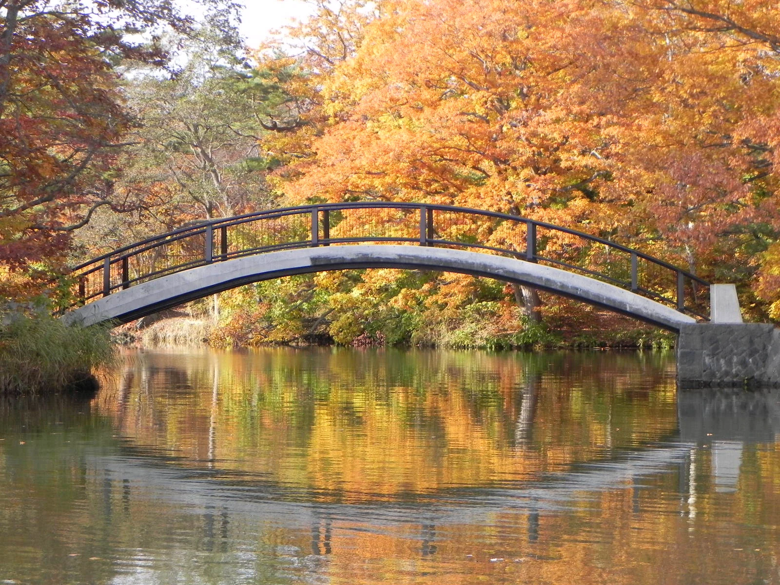
An arched pedestrian bridge crosses still water, with yellow and orange trees and their reflections behind it.

An arched bridge among autumn foliage at Lake Onuma, photographed on 5 November 2012.

紅葉のアーチ橋(Arch Bridge) - panoramio.jpg — pakku, CC BY 3.0 (https://creativecommons.org/licenses/by/3.0/). Source: https://commons.wikimedia.org/wiki/File:%E7%B4%85%E8%91%89%E3%81%AE%E3%82%A2%E3%83%BC%E3%83%81%E6%A9%8B%EF%BC%88Arch_Bridge%EF%BC%89_-_panoramio.jpg. Recompressed as WebP quality 92, method 6; original dimensions retained without upscaling. No crop, retouching, added text or colour adjustment. EXIF omitted from derivative; original retained as evidence only. · Creative Commons

Walks and routes

Shima-meguri: the island-and-bridge circuit

Follow the signed island circuit from Park Square. Seven islands give you changing views of coves, woodland and Komagatake. Stop where you can stand clear of other walkers and watch how the same tree or bridge changes in reflection. This route overlaps the shorter forest walk, so there is little need to rush around both.

Expect arched bridge approaches and mixed outdoor surfaces. For wheelchair or stroller travel, ask about Ōshima instead.

Shima-meguri: the island-and-bridge circuit

Ōshima: a shorter first look

Follow the Ōshima route for a compact loop with open lake views and the monument associated with the song “Sen no Kaze ni Natte.” This is a useful choice for a first stroll, a shorter connection between trains, or a party with different energy levels.

The April 2026 map lists wheelchair and stroller passage. Confirm surfaces, bridge approaches and any assistance needed locally, especially after rain or snow.

Ōshima: a shorter first look

Mori-no-komichi: the woodland loop

Choose this shorter loop for tree trunks, moss and birdsong. The route passes through the wooded island area, where a pause can reveal more than another ten minutes of walking. Look at the bark and leaves without leaving the path or handling plants.

This woodland route has bridge crossings, and wet surfaces can be slippery. For wheelchair or stroller travel, ask staff about the Ōshima route.

Mori-no-komichi: the woodland loop

Yūhi-no-michi: the Konuma-side walk

The small-lake route starts on the other side of the railway crossing from the main island paths. It trades the larger lake’s open panorama for quieter coves and waterside trees. Despite its sunset name, choose daylight for a first visit and leave enough time to get back to the station.

Ask specifically about Konuma Bridge and Suzuran Bridge before using the full loop. Older official route pages still carry deterioration cautions, so do not rely on an old map for their condition.

Yūhi-no-michi: the Konuma-side walk

Around Lake Onuma by bicycle

The approximately 14 km lakeside circuit takes you far beyond the walking islands. The local route guide gives 70 minutes of cycling; allow two to three hours with rental arrangements and stops. It shares roads with traffic. Choose it only if everyone is confident riding, and ask the rental shop about helmets, suitable bicycle sizes and the return deadline.

This is an on-road cycling outing, not a traffic-free family trail. Do not bring bikes onto the island walking courses.

Around Lake Onuma by bicycle

A relaxed 3–4-hour visit from the station

Begin with a map, toilets and current advice at the tourist office, then walk to Park Square. Spend 75–90 minutes on Shima-meguri, or substitute Ōshima if a shorter route suits you better. Return for lunch. If the weather and timetable line up, finish with the 30-minute cruise, leaving a comfortable margin for your train. Skip an activity rather than rushing the bridges.

When you have only an hour or so

Use 60–90 minutes for the station, Park Square and a slow Ōshima loop. Take one good lake-view stop and enjoy the nearby trees. This works better than squeezing the long island walk and a boat departure into a short train connection.

Things to try

Let the boat do the traveling

The sightseeing cruise circles among islands in Onuma and Konuma in about 30 minutes. It complements a walk by opening up views from the water. Regular departures are listed for May–October; April, November and any early-December operation are less regular and weather-dependent. Allow time for tickets and boarding, and ask about access if you use a wheelchair.

Paddle or row only when conditions suit

Pedal and rowing boats offer a more hands-on lake outing in the operating season. Ask staff to explain the permitted area and fit everyone’s life jacket before leaving. A guided canoe trip is another option if you prefer instruction; check the starting point and booking requirements rather than assuming every activity departs from Park Square.

Try a three-layer nature search

Pick a safe stopping place and notice one thing at water level, one on a tree trunk and one overhead. A reflected leaf, a patch of lichen and a bird call count just as much as a recognizable animal. Take photographs or make a sketch, leaving natural objects in place.

Keep a small indoor plan

The tourist office’s rest space is convenient while you decide whether a short walk still makes sense. On an open weekday, the Nature Center adds a compact introduction to the wetland. On weekends, plan around an open café or shorten the visit, because the Nature Center is closed. Strong winds are a reason to skip both woodland and boating, rather than exchange one for the other.

Wildlife and habitats

Mallard

Look for dabbling ducks beside sheltered water. A breeding-plumage male mallard has a glossy green head, but males become much less distinctive after breeding, so a brown-looking duck needs a closer look.

Great spotted woodpecker

Listen for tapping or a sharp call, then scan tree trunks. A great spotted woodpecker has strong black-and-white patterning and red beneath the tail; watch its movement up the trunk rather than trying to get close.

Whooper swan

In winter, ask staff about a safe land-based place to look toward the unfrozen channel between the lakes. Whooper swans use this open water while much of the lake is frozen. Keep well back from the edge and leave the birds undisturbed.

Let the day’s weather and season decide what you find. Watch quietly from open paths, use binoculars rather than approaching birds, and never offer food. The following are locally documented species to learn about, not a checklist you need to complete.

Stories and discoveries

The islands belong to a volcanic landscape

Komagatake is more than a backdrop. Its eruptive history shaped the lakes and scattered rocky material through the landscape. The shore-level scene is a good way to notice that connection without entering mountain terrain.

A wetland can look like woodland

The trees on an island and the plants floating beside it are parts of the same wetland setting. Onuma’s Ramsar recognition includes Onuma, Konuma and Junsainuma, not just a single viewpoint or birdwatching spot.

Not every yellow flower is the same water lily

The local flora includes several kinds of aquatic plants, including pond-lilies as well as water lilies. Notice leaf shapes and flower structure from the path, then ask a guide if you want a firm identification. Flower color alone is not enough.

When to visit

Spring: new leaves and a careful restart

As the snow retreats, early flowers and returning birds change the lakeside. Check for muddy or icy patches and wait for each operator’s actual season opening. Late spring is a useful choice if you want leafier walks and more dependable activity options.

Summer: water plants and shade

July and August are the main months to plan around water-lily flowers. Bring water, sun protection and insect protection, and use the wooded sections for a slower pace. Wind can still change a boat plan, even on a bright day.

Autumn: reflections and earlier finishes

Mid- to late October is a useful usual window for foliage. Allow time for photography without blocking bridges, and dress for cooler air by the lake. Event preparations can restrict walking routes: check the dated notice before choosing a circuit.

Winter: a different kind of lake day

Ask about guided snowshoe walks or a short land-based birdwatching visit. Do not follow summer walking times across snowy paths or assume the ice will support you. Winter operators change or cancel activities with ice conditions; the 2026 winter season has ended, and the next opening dates need checking.

Getting there and practical advice

Onuma Tourist Information, beside the station

The Onuma International Communication Plaza is the practical first stop for maps, route advice and a rest. The current listing is 09:00–17:00, with closure from 31 December to 2 January. There is an accessible toilet. Ask about wheelchair loans, their permitted use and availability before relying on one.

Onuma Nature Center

This separate town facility at Onuma 1024-1 explains wetlands and seasonal nature. Admission is free; hours are 09:00–17:00 on opening days. It is closed Saturdays, Sundays, public holidays and over the year-end period. Ask the tourist office for directions if you would like to add it.

Park Square and the station neighborhood

Food, souvenirs, boat services and bicycle rentals cluster around this gateway. Use the toilets before setting off, and check which facilities remain open in winter. Do not count on finding the same services once you ride farther around the lake.

Arrive at Onuma-Koen

Plan your rail journey from Hakodate or Shin-Hakodate-Hokuto to Onuma-Koen Station. Check that the train stops there, and choose the return service before your outing. Hokuto trains are all-reserved-seat limited expresses and need the appropriate ticket in addition to the basic fare. Onuma Station is a separate stop.

Walk from the station to the water

The official local guide gives about five minutes from Onuma-Koen Station to the Park Square entrance by the sightseeing-boat landing. Pick up the map first, then follow the signed approach. This is only the approach to the walks, not the 50-minute island circuit itself.

If you arrive by car

Use a signed visitor parking area around the main gateway and walk into Park Square. Check the current fee and event restrictions on arrival; do not park on the lakeside road to take photographs.

Choose the route before choosing the distance

Ōshima is the route specifically identified for wheelchairs and strollers on the April 2026 map. Ask staff about the full loop, surfaces and bridge approaches for your equipment. The longer island and forest circuits have different bridge crossings, so a short published walking time alone does not establish suitable access.

Check the two connections separately

For a rail-and-boat day, ask JR about boarding assistance for your train and the boat operator about the pier, gangway and vessel in use. The tourist office’s accessible toilet and wheelchair-loan listing do not establish step-free access through every part of the outing.

Visitor information

Before you travel: notices checked 16 October 2026

Walking-path restrictions are announced for 17–18 October during fireworks preparations. Ask the tourist office which sections and times are affected. The lakeside road also has event traffic restrictions on 1 November, 09:00–15:00. Komagatake’s Akaigawa mountain trail gate is closed and volcanic alert level 2 continues; check the latest local and weather-agency advice before any mountain plan.

Sources and useful links

Wildlife you might spot

3

Each card links to a full Explore page with photos, traits, and fun facts.

Snap map for this place

Start with the big picture, then zoom in to explore individual wildlife observations around this place.

Loading map…

Good to know before you go

Start with the tourist office’s latest map and notices. Stay out of closed paths, including temporary event and wildlife restrictions.

Check your return train before walking. Choose a service that stops at Onuma-Koen; Hokuto limited expresses require a reserved-seat ticket as well as the basic fare.

Wear shoes with grip and bring a rain layer, drinking water and an extra warm layer. Wet leaves, bridge surfaces and winter ice deserve care.

Keep children beside you at bridges and lake edges. On rental boats, wear a correctly fitted life jacket and follow staff instructions about wind, boundaries and return time.

Leave bicycles at the designated parking area before an island walk: all four walking courses prohibit cycling.

Never feed birds, squirrels or foxes. Do not touch foxes or drink untreated lake or stream water; carry out every scrap of food and litter.

Check Nanae's bear information before entering woodland or riding farther around the lake. Turn back from fresh bear signs or cubs; if you encounter a bear, back away slowly without running, shouting or turning your back.

In winter, stay off lake ice on your own. Choose a currently operating, supervised winter activity and follow its marked boundaries; a snow-covered surface is no assurance of safe ice.

Frequently asked questions

Use JR Onuma-Koen Station (大沼公園駅) for the main island walks. Onuma Station is a different stop. The tourist information office is beside Onuma-Koen, with Park Square about five minutes away on foot.
No. Shima-meguri explores the small islands near Park Square. The wider lakeside cycling circuit is approximately 14 km and uses roads; it is a separate outing.
Ask about the Ōshima route first: the April 2026 official map identifies it as passable by both. Confirm current conditions and the help you may need. Do not assume that the longer arched-bridge circuit or boarding a boat will suit the same equipment.
As checked on 16 October 2026, the operator lists ¥1,460 for adults and ¥730 for children aged 6–12 for the approximately 30-minute cruise. Junior-high students pay the adult fare. Recheck the fare and sailing on your date.
Yes, but plan a winter visit rather than assuming the summer circuit and boat timetable will work. Ask about cleared or guided walking options, dress for snow and ice, and view waterbirds from land. Only join ice activities that the operator has opened for current conditions.
Treat the mountain as a separate trip. As checked on 16 October 2026, the Akaigawa trail gate is closed and volcanic alert level 2 is in effect. The lake walk does not provide access to the mountain summit.
Pause at the station-side tourist office and its rest space. On a weekday, the separate Onuma Nature Center has free wetland and seasonal-nature exhibits; it is closed on weekends and public holidays. In strong wind or heavy rain, shorten the outing rather than treating a boat as a guaranteed fallback.

Recent snaps at this place

Recent snaps will appear here as new observations are added.

View all ›

Take the discovery with you

Exploring Onuma Quasi-National Park?

Identify the wildlife you spot, learn as you go, and keep a collection of the adventure.

  1. 1Spot it
  2. 2Snap it
  3. 3Keep the discovery