Snappit logo
Snappit
Get App
Generic illustration, not a photograph of this venueIllustration
ParkCastilla y León, Spain

Hoces del Río Duratón Natural Park

The Duratón makes a dramatic change below Sepúlveda.

About

The Duratón makes a dramatic change below Sepúlveda. The river winds into limestone and dolomite, leaving high walls above a much greener valley floor. On top, the dry plateau can feel exposed and spare; below, trees follow the water. Pause long enough to notice that contrast and the gorge becomes more than a distant view.

For an approachable first visit, start at the Casa del Parque in Sepúlveda’s former Santiago church. Its exhibition was renewed in April 2026 around the theme Naturaleza Sagrada, linking the landscape’s spiritual history with its value as a refuge for nature. A model of the park and bird replicas help put the places outside in context. Staff can help you choose a suitable walk and explain the day’s restrictions.

The nearby Senda de la Glorieta is a useful next step: a short out-and-back route designed for people with reduced mobility, with interpretation and places to rest. Look across the first gorges and pick out the folded rock known as Silla de Caballo. There is no need to descend to the river or complete a long circuit to have a rewarding visit.

San Frutos is a different outing, reached by a separate approach through Villaseca. Its Romanesque hermitage stands on a rocky projection above a great bend in the river. The walk is short, but the cliff setting demands care. Longer valley walks and canoe trips also need their own arrangements; choose one main outdoor plan rather than trying to fit every side of the park into a morning. Take the ultimate field guide with you: use the Snappit app to identify birds, plants, and animals on your trip.

The gorge has long been a place both to work and to withdraw from ordinary life. Riverside gardens, grazing, stoneworking and resin collection left traces in its landscape, while the monasteries and hermitages reflect a different relationship with the cliffs and river. San Frutos survives as part of a former monastic complex; Sepúlveda brings the wider medieval story into view. The park was declared in 1989. Its purpose combines protection of the landscape and ecosystems with compatible traditional uses and educational visits. The Casa del Parque opened in the restored Santiago church in 1994. Its 2026 renewal gives nature and cultural history a shared setting, including interpretation of the medieval burials in the former crypt.

What to do here

Visit the Casa del Parque, then follow the signed Senda de la Glorieta if its current condition suits your group. Use a quiet stop to compare river woodland, exposed rock and open plateau. For a longer walking day, choose the Dos Ríos circuit; for the famous hermitage view, make San Frutos a separate road-and-walk outing.

Seasonal info

Reserve-zone access is restricted during the bird-breeding period from 1 January to 31 July; the rules depend on the route and activity. Summer brings exposed, hot walking, while winter can bring cold winds and slippery ground. Ask about river levels before taking a canyon-floor path after rain.

Accessibility

The official Glorieta route is designed for visitors with reduced mobility and visual impairments, with wheelchair-height interpretation and rest furniture. Confirm the approach, surfaces and any assistance needed with the Casa del Parque. The centre’s entrance ramp was improved in 2026, but that does not establish step-free access to every exhibition floor. Dos Ríos has descents, steps and a cliff-side walkway; San Frutos has sloping ground and exposed surroundings.

Don't miss

1

The renewed Naturaleza Sagrada exhibition in Sepúlveda’s former Santiago church

2

A short first-gorge outing on the adapted Senda de la Glorieta

3

The contrast between dry plateau, rock walls and riverside woodland

4

The separate San Frutos hermitage walk above a bend of the Duratón

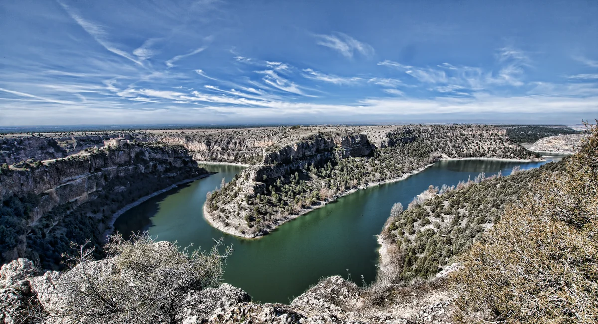
Green water curves between pale limestone cliffs and scrub-covered slopes under a wide blue sky streaked with white clouds.

A broad bend in the Hoces del Río Duratón, photographed in March 2012. This is wider park scenery rather than the short walk from Sepúlveda.

Hoces del Duraton.jpg — Jesus Solana / Wikimedia Commons / CC BY 2.0 Generic · Creative Commons 1 · Creative Commons 2

Walks and routes

Senda de la Glorieta: the short first-visit choice

Start in Sepúlveda beside the residential care home, near the Casa del Parque. Walk 800 m out and the same distance back, allowing about one hour in total. Follow the interpretation through views of the first gorges, the Silla de Caballo fold and the old town. Allow the benches and viewpoints to set the pace.

The park designates this as an adapted route for reduced mobility and visual impairments, with rest furniture and wheelchair-height panels. Ask about current surfaces, the easiest approach from your arrival point and any assistance needed; a town-centre address alone does not describe the whole accessible journey.


Senda de la Glorieta: the short first-visit choice

Senda de los Dos Ríos: a fuller canyon circuit

The official listing gives 5.6 km and two hours; allow about three hours with stops. The loop begins and ends at the Casa del Parque, links the Virgen de la Peña viewpoint with the rivers below and returns into Sepúlveda. The descent, bridges, wooden ICONA walkway beneath the cliff and uphill finish make it a walking outing rather than a level town stroll.

Rated medium difficulty in the official listing. Expect changes of level, steps and a narrow-feeling cliff-side walkway. Choose Glorieta instead if your group needs the adapted option, has a pushchair or is uncomfortable with heights.

Senda de los Dos Ríos: a fuller canyon circuit

Camino de acceso a San Frutos: hermitage and gorge views

From the San Frutos parking area, the official route runs 925 m to the former monastic site and returns the same way. Allow 1–1½ hours for the roughly 1.9 km walk, pauses and the view over the bend. The marked approach crosses the stone bridge over La Cuchillada. Enjoy the building and landscape from the normal visitor route; do not explore cliff-side shortcuts.

The official route is low difficulty with a slight slope, but it is not identified as an adapted route. Exposed surroundings, uneven ground and the bridge require close supervision and comfortable footwear. A short distance does not remove the cliff risk.

Camino de acceso a San Frutos: hermitage and gorge views

Puente de Talcano–Puente de Villaseca: a separate long walk

The official route description gives 10 km and three hours in one direction, or 20 km and six hours walking if you return on foot, before stops. The route follows the valley through the reserve area and traces a former access way to riverside gardens. Plan transport at both ends if you do not intend the full return; do not assume a pickup or shuttle is available.

The official description is largely level, but the length, isolated setting and variable natural surface make it a different commitment from Glorieta. For a wheelchair outing, discuss Glorieta with the centre instead.

Puente de Talcano–Puente de Villaseca: a separate long walk

An unhurried first visit

Allow 1½–2½ hours. Begin with the Casa del Parque while it is open, then walk Glorieta out and back if conditions suit your group. Leave enough time to rest, look across the gorge and return without rushing. Finish in Sepúlveda rather than automatically adding a second drive.

A longer morning on foot

Choose Dos Ríos as the day’s main walk, after checking the river sections and walkway. Give the circuit about three hours with stops and add the exhibition only if its hours and your energy allow. Decide before the descent whether everyone is comfortable with the terrain and the climb back.

A full day with San Frutos

Visit the centre and choose one short Sepúlveda outing, then leave space for lunch and the separate drive through Villaseca towards San Frutos. Keep 1–1½ hours for the hermitage walk, plus travel and parking time. If wind or tiredness builds, keep San Frutos for another day.

Things to try

Read the landscape in three layers

From an open viewpoint, ask everyone to find the river’s green line, the rock walls and the drier land above. Then look for the bent layers of Silla de Caballo from Glorieta. A sketch or a quick comparison of shapes makes the geology easier to remember than a list of rock names.

Try five quiet minutes

Find a safe place clear of the path and spend a few minutes listening before using binoculars. Notice a sound, a flight shape and a patch of habitat rather than trying to complete a species checklist. Keep away from nesting sites and give people and livestock room to pass.

Make canoeing a separately planned activity

Canoeing offers a river-level view, but it is regulated and depends on the season, zone, river conditions and operator. Ask the Casa del Parque about authorized providers. Before booking, establish the meeting point, permitted route, lifejackets, swimming/age requirements, weather cancellation terms and return transport. An independent boat needs its own applicable park and CHD arrangements; the CHD currently requires its navigation declaration at least one month in advance.

Photograph the whole setting

Use the ordinary marked route for views that put river, rock and buildings together. Stay away from the edge even if a wider angle is tempting, and leave nesting birds undisturbed. Commercial photography and drones need park authorization.

Use the church exhibition when outdoor conditions deteriorate

If the centre is open, spend more time with the park model and the relationship between wildlife, geology and religious history. It is a useful visit in its own right. Check its calendar first, particularly on Tuesday or Wednesday, rather than relying on it as an always-open fallback.

Leave a flooded path for another day

Ask staff about the specific route before descending after heavy rain. The foundation has issued a Duratón high-water path-closure poster; follow any current barriers and advice on the ground. Do not wade through floodwater or invent a route around a closed walkway. In wind or poor visibility, postpone the exposed viewpoints too.

Wildlife and habitats

Griffon vulture

Look first for a broad-winged bird circling above the gorge. The park’s interpretation makes the griffon vulture a good introduction to how cliffs and rising air shape bird life. Use binoculars from a safe public path and keep your attention on birds in open flight.

Egyptian vulture

This smaller vulture is part of the park’s wild bird community. Adults have a pale body contrasting with dark flight feathers and a wedge-shaped tail. Mainland birds are mainly summer visitors, so learn its outline in the exhibition without making it a winter expectation.

Black alder

The official river-walk interpretation identifies alder close to the water. Use it as a reason to compare the dense riverside woodland with the sparse plateau above. Enjoy the trees from an open signed path; there is no need to step down a bank or enter the water.

Great tit

Do not spend the whole visit looking skyward. The park’s birdwatching leaflet includes this small bird, with yellow underparts, a black head and white cheeks. A quiet pause near trees can be just as absorbing as scanning the cliffs.

European robin

The orange face and breast offer a useful identification clue if a robin appears near cover. Let the bird move at its own pace and watch without tempting it with food. The small birds make a pleasing contrast with the canyon’s large soaring raptors.

Stories and discoveries

A fold you can recognise

The Silla de Caballo name describes a rock fold resembling a saddle. Glorieta’s interpretation connects it with folding during the Alpine orogeny and later erosion. The nearby serrated rock forms are locally called picozos.

The park extends beyond the river

The official park account separates four broad settings: dry plateau, river woodland, cliff vegetation and pinewoods on windblown sand in the southwest. The shaded-looking river strip and the open land above belong to the same protected landscape.

A landscape with livelihoods

The gorge’s history includes vegetable gardens beside the water, grazing on the open ground, stoneworking and resin collection. The long valley path once helped people reach their riverside plots. Respect working tracks, private land and shepherds today.

When to visit

Spring: fresh growth and breeding birds

Take time for river vegetation and birdsong, but remember that reserve-zone restrictions already apply from January. Book the specific authorization needed for a long valley route and keep a generous distance from breeding cliffs.

Summer: start cool and carry water

Choose the cooler part of the day and reduce exposed walking when it is hot. San Frutos’ official description specifically recommends avoiding the hottest hours. Reserve-zone restrictions continue through 31 July, and an August date still does not remove activity or group rules.

Autumn: woodland colour and quieter pauses

Autumn is a rewarding time to compare riverside foliage with the pale rock and dry plateau. Use a calm, clear day for the views, and check the centre’s shorter afternoon pattern from 1 November. Daylight and wet ground should shape any longer walk.

Winter: wind, water and a shorter plan

Dress for the exposed plateau and check conditions after rain or frost. Keep the centre-led visit as an alternative to a descent into the gorge. The reserve breeding-season rules restart on 1 January; do not assume winter means unrestricted access.

Getting there and practical advice

Information and the renewed exhibition

The Casa del Parque is at Calle Conde de Sepúlveda, 34, in the former Santiago church. Staff provide park information and help with permits: +34 921 540 322, [email protected]. Naturaleza Sagrada, renewed in April 2026, brings the landscape, wildlife and cultural history together through models, replicas, sound and interpretation.

2026 opening pattern

The operator’s calendar gives 10:00–15:00 on Mondays, Thursdays, Sundays and public holidays. Fridays, Saturdays and holiday eves also open 16:00–19:00 from 23 March to 31 October, changing to 16:00–18:00 in the winter periods. Tuesdays and Wednesdays are normally closed, as are 1 and 6 January and 24, 25 and 31 December. Check holiday exceptions and any revised calendar; groups can request an arranged visit.

Centre admission and bookings

The regional tourism listing shows €1 general and €0.50 reduced admission. Confirm the current charge, reduction eligibility and any guided-visit price with the centre. Groups should reserve in advance; do not treat an ordinary opening day as a group booking.

Water, toilets and a place to pause

Plan toilet and drinking-water stops in Sepúlveda before a longer outdoor section, and ask the centre which facilities meet your needs. Carry a filled bottle and food rather than relying on an open outlet at a trailhead. Glorieta has rest furniture; picnics belong in the signed recreation areas.

Arrive in Sepúlveda first

For the recommended short visit, navigate to Sepúlveda and use signed public parking, then follow local information to the Casa del Parque. The municipal arrival page gives A-1 approaches from Madrid and Burgos. Check the final town approach and any parking restrictions; do not assume you can park at the church door.

Public transport needs a return plan

The municipal site lists limited Aisa and Linecar connections, including transfers via Santo Tomé del Puerto or Boceguillas. Check both operators for your exact date and arrange any taxi leg in advance. Confirm the return before leaving home; these listings do not establish a daily direct bus or a shuttle to San Frutos.

The separate San Frutos approach

The park describes access from Villaseca along a dirt track ending at the San Frutos parking area. Ask about the track’s condition before taking your vehicle, especially after bad weather. The walking route begins at the parking area, not in Sepúlveda; park only where permitted and keep emergency access clear.

Check the whole Glorieta journey

Tell the centre what equipment you use and whether you need assistance. Ask about the path, the connection from parking or a drop-off point, benches and a suitable toilet. The route’s official adapted status is helpful, but current surface damage, weather and the approach through town can still affect your day.

Ask which exhibition levels you can reach

The centre occupies a multi-level historic church. The 2026 work improved the entrance ramp and information, but the renewal announcement does not provide a complete floor-by-floor access description. Ask staff to explain the spaces you can reach, including the former crypt, before planning around them.

Choose a route for the least confident walker

Dos Ríos adds descent, a cliff-side walkway and a return climb; San Frutos is short but exposed. If height, balance, heat or stamina is a concern, keep to the centre and an agreed part of the adapted outing. Turning back early is a sensible way to keep the visit enjoyable.

Sources and useful links

Wildlife you might spot

5

Each card links to a full Explore page with photos, traits, and fun facts.

Snap map for this place

Start with the big picture, then zoom in to explore individual wildlife observations around this place.

Loading map…

Good to know before you go

Contact the Casa del Parque before travelling if your plan depends on a permit, a particular path or accessible facilities: +34 921 540 322, [email protected].

Keep well back from cliff edges and supervise children closely. In strong wind, fog or slippery conditions, choose the indoor visit or postpone the exposed walk.

Bring water, sun protection, a windproof layer and shoes with grip. Do not rely on untreated springs or the river for drinking water.

Save the official route information offline and tell someone your plan for a longer walk. The park warns that mobile reception is absent on the canyon floor; call 112 in an emergency when a connection is available.

Use only signed paths and designated parking. Do not cross a closure, block a track or turn a roadside verge into an extra parking space.

Watch birds quietly through binoculars, without approaching nesting cliffs, using playback or feeding them. Keep dogs under close control, preferably on a lead near wildlife and livestock.

Picnic only in signed recreation areas, take rubbish away and leave plants, fungi, stones and archaeological remains where they are. Fires, wild camping and overnight stays inside the park are prohibited.

Climbing and caving are not permitted. Drone flights and photography for commercial purposes require park authorization; ordinary photography must still avoid disturbing wildlife.

Frequently asked questions

At the Casa del Parque in the former Santiago church, Calle Conde de Sepúlveda, 34, Sepúlveda. It is the practical starting point for this guide’s short visit. San Frutos uses a different approach and is not a short extension of the town walk.
No single permit rule covers every path. The Talcano–Villaseca route enters reserve zones and requires authorization from 1 January to 31 July. The municipal guidance says only groups of more than 20 need a permit for Dos Ríos and La Molinilla. Contact the centre with your exact route, date and group size, and follow any additional closure signs.
Ask first about the Senda de la Glorieta and the route from your parking or drop-off point. Its adapted designation makes it the most useful starting option here. Confirm the centre’s indoor access and toilets separately. The full Dos Ríos circuit and the San Frutos approach do not share that access standard.
The published 2026 calendar normally closes it on Tuesdays and Wednesdays, with additional holiday closures. Morning opening on its other regular days is 10:00–15:00; Friday, Saturday and holiday-eve afternoons vary by season. Check the linked calendar before setting out.
The regional tourism listing gives €1 general admission and €0.50 reduced admission for the Casa del Parque. Check the current price and reduction eligibility with the centre, especially for guided or group visits. Paid canoe activities, transport and any parking charge are separate.
Arrange canoeing in advance. Park conditions and the Confederación Hidrográfica del Duero’s navigation requirements both apply, with further seasonal and zone restrictions. For a first trip, ask the centre about authorized operators and confirm what permits, safety equipment, age limits and return arrangements the provider includes.
Griffon vultures are a characteristic wild bird of the park, and the official interpretation also includes Egyptian vultures and other raptors. Give yourself time to scan the open sky from a safe place. Wildlife appears on its own terms; a quiet walk can be worthwhile even without a particular sighting.
No. They are separate natural parks. This entry covers the Duratón gorge and its associated plateau and woodland across Sepúlveda, Sebúlcor and Carrascal del Río in Segovia.

Recent snaps at this place

Recent snaps will appear here as new observations are added.

View all ›

Take the discovery with you

Exploring Hoces del Río Duratón Natural Park?

Identify the wildlife you spot, learn as you go, and keep a collection of the adventure.

  1. 1Spot it
  2. 2Snap it
  3. 3Keep the discovery