
Snappit logo
Snappit
Get App
Generic illustration, not a photograph of this venueIllustration
ParkIT

Pollino National Park

The park also includes the Orsomarso mountains and Monte Alpi.

About

The park also includes the Orsomarso mountains and Monte Alpi. For a first visit, the Rotonda–Viggianello side makes sense for forest walks and central mountain trailheads. Orsomarso offers a western valley alternative; Civita and the other Arbëreshë communities bring language and living culture into the trip. Choose between these areas rather than attempting a quick circuit of them all. Unlock an interactive field guide for this spot: get the Snappit app to identify nature on the go.

The national park was established in 1993, protecting a landscape already shaped by long relationships between people, forests and mountain pastures. Its cultural history includes Arbëreshë communities founded by people arriving from Albania in the late fifteenth and early sixteenth centuries. Civita, Lungro, Frascineto and San Paolo Albanese are among the places where that heritage remains part of everyday life. The park describes museums of Arbëreshë culture in Civita and San Paolo Albanese; check their opening arrangements separately. Treat religious services and community celebrations as living traditions, and ask before photographing people.

What to do here

For a relatively modest mountain walk and a view of the emblematic pines, consider Belvedere del Malvento. For old woodland, look at Cozzo Ferriero. Stronger walkers can plan Monte Pollino from Colle Impiso. For a lower-effort day, combine Rotonda’s Ecomuseo with a village visit or investigate the introductory riverside walk at Orsomarso. The individual route notes below will help you choose.

Seasonal info

Snow can linger on the high mountains well into spring. In summer, start exposed walks early and turn back before a building storm becomes a problem. Autumn is a good reason to spend time in the beech woods, but shorter daylight and wet leaves affect your pace. Once snow or ice is present, the walking grades in this guide no longer describe the skills and equipment required.

Accessibility

Wheelchair and pushchair access has not been certified for these outings. Ask about the exact surface, slope, barriers, toilets and parking-to-entrance distance. The Ecomuseo is a useful indoor option to investigate; arrange any access support directly.

Don't miss

1

Loricato pines with plated bark and wind-shaped crowns

2

Old beech forest at Cozzo Ferriero

3

A high-mountain day on Monte Pollino

4

Arbëreshë villages and the park’s cultural landscape

Walks and routes

Belvedere del Malvento: the shorter mountain option

The official route 900 runs from Rifugio A. De Gasperi at 1,535 m to Belvedere del Malvento at 1,581 m. The published length is 2.1 km between those endpoints, with 61 m of ascent and 15 m of descent, graded E for hiking. Returning along the same route would make about 4.2 km; that return distance is a simple planning calculation, not a separate official circuit. Give yourself an unhurried half day including the approach drive. The attraction is a mountain outlook with a chance to appreciate the loricato pines without committing to a summit. This is still an outdoor trail, not a certified accessible promenade. Open the official Malvento route sheet.
Cozzo Ferriero: a forest day with a real climb

Route 904C begins at Rifugio Fasanelli, 1,356 m, and reaches the junction with route 908 at 1,790 m. Its official sheet gives 2.6 km, 434 m of ascent and an E hiking grade. Despite the short distance, the climb makes this a different proposition from Malvento. An out-and-back on the same line would be about 5.2 km, calculated from the published section length; allow a substantial half day and settle the return plan before starting. Ask a park guide about the current authorised way to experience the old beech forest. The route sheet names water at Rifugio Fasanelli, but carry your own rather than depending on it being available. Open the official Cozzo Ferriero route sheet.

Monte Pollino: save a full day for the high mountain

The official IPV2 itinerary links Colle Impiso, 1,575 m, with Monte Pollino, 2,248 m, over a published 5 km section, graded E. Plan the descent as well: retracing that section gives about 10 km in total, an editorial calculation. Choose this only with the fitness, navigation skills, clothing and forecast for a full mountain day. Start early, carry a proper map and make a turnaround decision before cloud or fatigue takes the choice away. The official sheet lists Sorgente Spezzavummola and Fontana Gaudolino as water points, but neither is a current assurance of flow or drinking-water quality. Snow and ice require a different level of competence. Open the official Monte Pollino route sheet.

Orsomarso: a gentler introduction to the western valleys

For a different side of Pollino, consider the Valle del Fiume Argentino reserve near Orsomarso. The Carabinieri visitor description gives a road approach below the town to a large parking area, followed by a walk to an educational arboretum, a fountain and, beyond the Ficara waterfall, a medicinal-plant garden. This makes a useful lower-effort option to discuss with the reserve staff, rather than treating the whole valley as an easy trail. The description supplies no checked distance, gradient profile or step-free certification. Ask which section is currently usable, especially after rain, and turn back before any unsafe crossing. Read the reserve’s visitor information.

A flexible first stay

With two full days around Rotonda or Viggianello, use one for Malvento and village time. Keep the other flexible: Cozzo Ferriero for woodland, Monte Pollino for a longer mountain day, or Rotonda’s museum in poor weather. Check museum weekdays first. Save Orsomarso or an eastern village day for a longer stay.

Things to try

Leave room for the villages

Pick one village for an unhurried afternoon after a forest morning. Check a museum or church’s visiting arrangements before building the day around it, and leave time to explore the streets as well.

An indoor day is worth planning ahead

Rotonda’s Ecomuseo explains the natural and cultural park. Arbëreshë cultural museums offer another indoor possibility if you have confirmed opening. In heavy rain, choose an indoor visit rather than retreating into a river valley.

Wildlife and habitats

European beech

The park’s dominant high woodland tree; compare the living canopy with the dead wood of an old forest.

Silver fir

Documented mixed with beech, particularly on the northern side of the park.

Black woodpecker

A documented forest bird; listen quietly rather than trying to draw it in.

Golden eagle

A documented breeding raptor. Watch distant birds without approaching cliffs or nest sites.

Wolf

A wild park resident, but not a reliable sighting on a daytime walk.

Eurasian otter

Documented along suitable park rivers; protect bankside cover and avoid disturbing it.

Roe deer

The park describes a native population in the Orsomarso mountains.

Wildlife without a checklist chase

These species are documented in the park. Keep binoculars handy, stay on the path and enjoy the habitats without searching out breeding or resting places.

Stories and discoveries

The tree that explains the skyline

The pino loricato is the park’s emblem. Older trees develop large grey bark plates, the armour-like texture behind the Italian name, while exposure can shape their branches into uneven, flag-like crowns. Many grow on rocky ground above the main beech belt. Look at the contrast between a compact woodland canopy and the isolated outlines on a ridge. Some dead trunks remain standing for a long time because of their resin-rich wood. They are part of the landscape too, not material to collect. The park’s own account points to Belvedere del Malvento, the Piani di Pollino and Colle Gaudolino as places to appreciate the species.

Why an untidy forest matters

Cozzo Ferriero and Pollinello are separate components of the transnational UNESCO beech-forest World Heritage site, inscribed in 2017 and 2021 respectively. In an old forest, young trees, large living trunks and dead wood occupy the same space. That mixture is one reason to slow down rather than look only for the biggest tree. Stay on the authorised route and leave fallen wood where it lies. A path carrying the name Cozzo Ferriero should not be read as unrestricted access to every part of the protected forest.

When to visit

Check both the sky and the catchment

Read the regional weather and civil-protection information for the side you will visit, then ask locally about the trail and access road. Avoid riverbeds and narrow gorges when rain or thunderstorms threaten, including storms upstream. If wind, snow or low visibility makes the heights unsuitable, change the day rather than just shorten the summit route. Basilicata weather and alerts; Calabria weather and alerts.

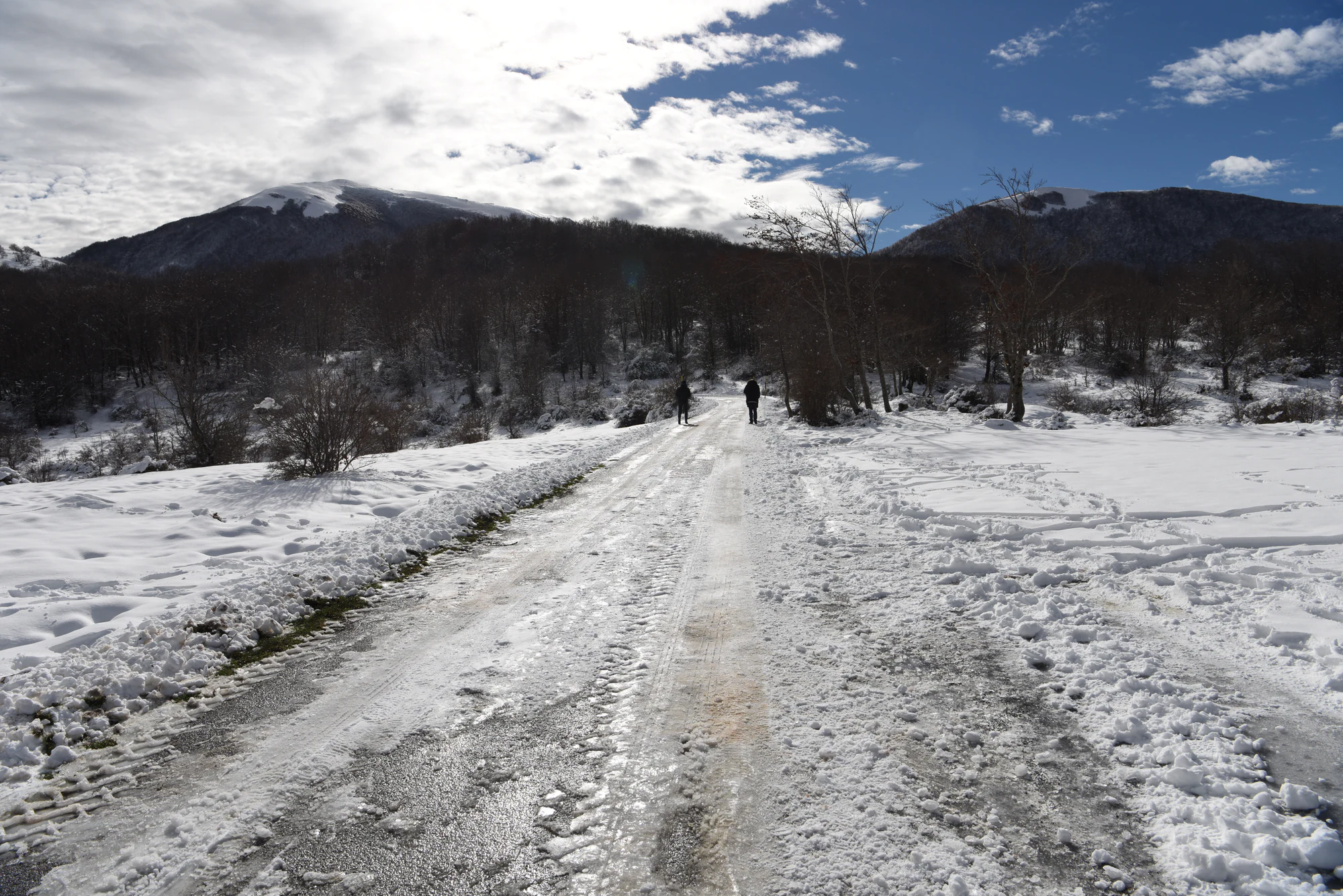
Two rear-facing walkers on a snow-covered track through leafless woodland, with dark mountain slopes and snowy heights beyond.

A winter landscape in the Viggianello area of Pollino National Park, photographed in December 2021. This historical scene does not show current snow or access conditions.

“Pollino zona Viggianello.jpg” — Diana Cimino Cocco, via Wikimedia Commons. CC BY-SA 4.0. Unmodified offered original. Copyright notice supplied: @DIANA CIMINO COCCO. · Creative Commons

Getting there and practical advice

Rotonda’s Ecomuseo and practical supplies

The Ecomuseo del Pollino “S. Berardone” is in the Santa Maria della Consolazione complex in Rotonda. As checked on 19 October 2026, its official page gives Monday–Friday, 09:00–13:00 after the special summer opening period, and says online reservations are suspended. Confirm a visit directly, including admission, group arrangements and any accessibility needs. The summer 2026 information desks at several park locations had date-limited schedules ending by September; do not rely on them for an autumn visit. Buy food and fill water bottles before heading up. A refuge name on a map does not establish that a café, toilet or staffed shelter is operating. Check the Ecomuseo notice.

Maps and local help

For unfamiliar mountain routes, use the park’s official guide directory and trail maps. This overview does not provide navigation. For current roads, restrictions and visitor services, the park contact is +39 0973 669311. Find an official park guide; find official trail maps.

Getting there without losing the day to travel

Choose your base before choosing your arrival point. The park identifies A2 motorway exits including Lauria, Laino Borgo, Campotenese, Frascineto and Castrovillari; from the Ionian side, the SS106 connects with inland approaches including the Sinni valley and the Sibari–Castrovillari road. A car makes the separate trailheads easier to combine, but check the final mountain road rather than assuming a navigation app knows its condition. For public transport, the park lists rail gateways including Maratea, Scalea and Sibari, with onward bus connections, and names COTRAB in Basilicata and TNC in Calabria. Treat these as starting points: verify your actual date, stop and return service with the operator. A bus to a village is not necessarily a transfer to Colle Impiso. Arrange the last leg before committing to a remote walk. Read the park’s arrival guidance.

Plan the part that works for you

At the Argentino entrance, specifically check the route from the car park, damaged surfaces, resting places and the nearest usable toilet. In Rotonda, ask about step-free entry and the exhibition route. A short, suitable section can be a better choice than committing to an entire named itinerary.

Visitor information

Restrictions to take seriously

The park’s regulations page still lists the 2018 prohibition on hiking and alpinism in the mapped Via delle Capre area at the Raganello. Do not use that route, and do not infer that other gorge sections are open: obtain current, place-specific advice from the park and municipality before considering any river activity. Elsewhere, follow barriers and temporary restrictions even when a trail appears in an official catalogue. Leave plants, wildlife and geological material undisturbed. Camping needs a designated equipped area or specific authorisation. Check local fire restrictions and use a picnic that needs no flame when in doubt. Read the park’s regulations.

Sources and useful links

Wildlife you might spot

7

Each card links to a full Explore page with photos, traits, and fun facts.

Snap map for this place

Start with the big picture, then zoom in to explore individual wildlife observations around this place.

Loading map…

Good to know before you go

Check the access road as well as the footpath before leaving your base.

Carry your water and lunch; a named spring or refuge is not a service guarantee.

Keep the return journey in your daylight budget.

Use established paths and give ancient trees and their roots room.

Keep wildlife viewing quiet and distant; do not use bait or recorded calls.

Take all rubbish back, including food scraps.

Frequently asked questions

Belvedere del Malvento is the shortest of the three measured mountain routes here, with much less ascent than Cozzo Ferriero. It still carries an E hiking grade. For a day without a mountain trail, begin with Rotonda and the Ecomuseo.
Yes. The park identifies Belvedere del Malvento as a viewpoint for them. Stay on the path; visibility and access depend on conditions.
Do not include a gorge descent in a self-guided plan. Current permitted access has not been confirmed for this guide, and the park still lists a specific prohibition covering the Via delle Capre area. Ask the park and the relevant municipality about the exact place and date; an old tourism description or an advertised excursion is not proof that entry is permitted.
Plan each activity separately: museums, guides and parking may have their own charges and arrangements. A current, comprehensive fee schedule has not been verified; check your chosen services directly.
No. The park’s published safeguards prohibit camping outside designated, equipped areas, while providing for specifically authorised temporary camping. Arrange a lawful overnight place in advance; a secluded clearing is not an invitation to pitch a tent.
Both are documented, but neither is a dependable visitor sighting. Enjoy the habitat without pursuing animals, approaching resting sites or entering riverside cover.

Recent snaps at this place

Recent snaps will appear here as new observations are added.

View all ›

Take the discovery with you

Exploring Pollino National Park?

Identify the wildlife you spot, learn as you go, and keep a collection of the adventure.

  1. 1Spot it
  2. 2Snap it
  3. 3Keep the discovery















