
Snappit logo
Snappit
Get App
Generic illustration, not a photograph of this venueIllustration
ParkAuvergne-Rhône-Alpes, FR

Monts d’Ardèche Regional Nature Park

The Monts d’Ardèche spread across Ardèche and part of Haute-Loire in Auvergne-Rhône-Alpes.

About

The Monts d’Ardèche spread across Ardèche and part of Haute-Loire in Auvergne-Rhône-Alpes. This is a lived-in landscape of villages, working woods, orchards and upland pastures. Mediterranean-influenced valleys give way to cooler mountain forests, while streams and volcanic rock create striking changes of scenery. A single afternoon can introduce these contrasts, but it cannot cover the whole park.

Jaujac is a particularly useful starting point because the landscape has a story you can follow on foot. The Maison du Parc occupies the Rochemure estate below the Coupe de Jaujac. Gardens, water features and woodland offer a gentle first visit; beyond them, a longer route connects village streets, basalt columns and the crater. Choose between these outings before you leave, rather than treating the volcano as an automatic extra.

The wider uplands deserve a separate day. Around the Gerbier–Mézenc sector, open farming landscapes sit alongside wooded slopes and volcanic landforms. Eager to name that creature? Identify any animal you find during your visit using the Snappit app.

Chestnut growing helped bring this park into being. Producers promoted the regional-park project in the 1990s, and the chestnut became a central element of its identity when the park was created in 2001. The orchards had already sustained generations of people on the slopes; today, maintained groves, older abandoned orchards and coppice show different chapters of that history. Rochemure has its own agricultural past. The Maison du Parc occupies an eighteenth-century farm transformed in the nineteenth century, and has welcomed visitors at Jaujac since 2009. Its gardens and estate make a fitting place to explore how rural work, conservation and everyday life fit together.

What to do here

Follow the Sentier qui pétille, then spend time in the biodiversity gardens. Children can compare the irrigation basin, pond and spring: what makes each place useful to plants, animals or people? If you want a longer outing, use the official Coupe de Jaujac et sa coulée itinerary and its route description.

Seasonal info

The local tourist office advertises the short trail year-round, while the Maison du Parc exhibitions and shop have seasonal opening dates. Autumn can bring chestnut colour and rain; winter conditions are more demanding on the uplands. Always match the visit to the day’s forecast and local notices.

Accessibility

The natural Sentier qui pétille requires an all-terrain wheelchair for visitors using a chair. The gardens and immediate Maison du Parc surroundings offer a less demanding alternative. The longer crater circuit includes stairs and a climb and is unsuitable as a step-free outing.

Don't miss

1

A 1.2 km discovery loop linking three different water features

2

Gardens designed for biodiversity at the foot of a volcano

3

Jaujac’s basalt columns and wooded crater on the longer walk

4

Chestnut-growing country and a much wider upland landscape

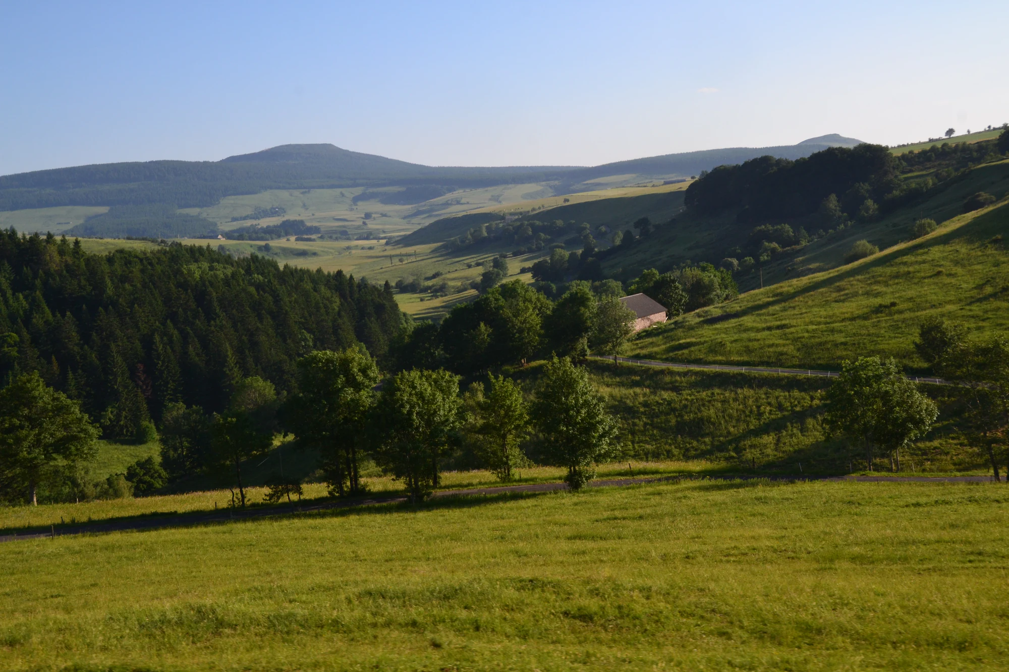
Green pastures and wooded slopes surround a farm building and winding roads below rounded uplands.

Pastures and wooded slopes in the wider Mont Gerbier-de-Jonc area, photographed on 29 June 2019. This landscape view gives context for the wider park; it does not show the Jaujac walk.

“Alentours du mont Gerbier de Jonc” — Jeanne Menjoulet, CC BY 2.0. Source: https://www.flickr.com/photos/jmenj/9336340337/. License: https://creativecommons.org/licenses/by/2.0/. Original unchanged. · Creative Commons

Walks and routes

Sentier qui pétille: the short discovery loop

Start at the Maison du Parc and follow the signed loop around the estate’s irrigation basin, dragonfly pond and Peschier spring. Stay with this loop if you want an easy-to-manage first visit, rather than following the separate climb towards the crater.

At one stop, let children describe what the water is doing before reading the interpretation. Is it held in a basin, spread through a pond or emerging from the ground? The answer provides a useful thread between the stops without turning the outing into a species checklist.

This is a natural-surface trail. Allow time for rests and confirm suitability for your pushchair or mobility equipment; an ordinary wheelchair should not be assumed suitable.


Sentier qui pétille: the short discovery loop

Coupe de Jaujac et sa coulée: the longer outing

The official figure-of-eight route starts at Jaujac’s village square. One part explores the old village and basalt beside the Lignon; the other crosses Rochemure and climbs through chestnut and pine woodland to the volcano. Returning through the village between the two parts makes it possible to stop after one, as the operator suggests.

Use the official directions, rather than improvising a connection between viewpoints. The optional crater-rim circuit starts with a steep climb. Decide on that addition while everyone still has energy for the descent.

Although graded easy by the operator, the full walk includes stairs, uneven ground and 220 m of ascent. It suits families already comfortable with a longer hill walk, rather than first-time walkers or pushchairs.

Coupe de Jaujac et sa coulée: the longer outing

A relaxed first visit

Begin with the short water loop, then choose a garden bench for a break. Add an exhibition if it is open, or let the gardens be the final stop. Allow 1–2 hours outdoors; with young children, a picnic and one indoor activity can comfortably fill a half-day without a crater climb.

A walking half-day

Arrive with the full official route saved and enough food and water for the outing. Complete one side of the figure-of-eight, reassess at the village, and continue only if conditions and energy allow. Keep the rim extension optional. A leisurely village stop afterwards is a better finish than rushing down the volcano to a tight departure.

Things to try

Explore the gardens on both sides of the house

The Jardin côté village brings flowering apple trees, planted squares and views towards Jaujac into a designed setting. On the other side, the Jardin côté volcan draws on local geology and gives pollinators a place among flower-rich beds. Compare the two designs: one frames an arrival and a village view, while the other leads your attention towards the estate. Both show that a garden can welcome wildlife without looking like untouched wilderness.

Read a volcanic landscape

The Coupe de Jaujac has a horseshoe-shaped crater open to the north. Lava moved down the Lignon valley, and the river later cut into it, exposing the basalt columns. Those columns and the wooded cone tell different parts of the same story. From an established viewpoint, look for the contrast between regular rock shapes and the river’s irregular course. There is no need to climb onto the columns to appreciate them.

Give the pond a few quiet minutes

At the mare aux libellules, watch from the path or designated stopping place. On a suitable day, movement above the water may be easier to notice than an animal resting among stems. Try watching one small patch rather than searching everywhere at once. The pond’s name is an invitation to look, not a promise of insects in every season, and photographs should be taken without handling wildlife.

If the weather turns

When the Maison du Parc is open, its exhibitions offer a useful indoor continuation of the visit. In light rain, the gardens may be enough if surfaces remain comfortable. For storms, strong wind or flood warnings, postpone the outdoor route rather than seeking shelter under trees or pressing on beside the river.

Wildlife and habitats

The tree behind the landscape

Chestnut trees are part of the Jaujac estate as well as the wider park. Look at the spacing and shape of trees: an orchard and a dense stand tell different stories about management. Some old trees contain cavities and dead wood used by wildlife. Enjoy the grove from the path and leave its crop to the grower.

A clue to the cooler mountains

Beech belongs to the park’s cooler upland forests, often alongside fir. It helps explain why a mountain woodland can feel very different from chestnut country lower down. Look for it on another day in the wider park, rather than on Jaujac’s short water trail.

An old-tree neighbour

The park highlights this migratory bird among the inhabitants of chestnut groves. It can use cavities originally made by woodpeckers, a reminder that an ageing orchard offers more than a crop. Watch woodland edges quietly and leave hollow trees undisturbed. Presence in the wider park does not mean you will see one at Jaujac.

A river success story

Otters have recolonized the territory after their earlier disappearance from the department. Their return is part of the story of the park’s rivers, even when the animals remain unseen. Appreciate connected banks and quiet waterside cover from the trail; do not search for resting sites or approach wildlife for a closer photograph.

Stories and discoveries

Many varieties, one familiar crop

The Châtaigne d’Ardèche appellation embraces 65 eligible varieties. The conservation orchard at the Maison du Parc is intended to preserve that local diversity and study how varieties respond over time to a changing climate. It offers another way to think about biodiversity: variation within a crop matters alongside the number of wild species around it.

Why the hills are not all wooded

Much of the park’s open grassland is maintained by grazing or mowing. The pasture-and-woodland mosaic in the wider Gerbier landscape is therefore also a record of farming. When exploring beyond Jaujac, treat fields as working land, follow signed public paths and leave gates as instructed. A view across a meadow is not an invitation to walk through it.

When to visit

Heat and fire weather

Shade does not remove the effect of a hot day. Shorten the walk, avoid the hottest hours and carry water. Check Ardèche’s official fire information and local orders before entering woodland. Never light a fire or barbecue on this outing, and park on a suitable surface rather than dry vegetation. A risk map does not replace a closure sign.

Rain, wind and shorter days

After heavy rain, choose a different day for the Lignon section; fast-rising water and slippery rock change the character of a walk. Strong wind is a reason to avoid woodland. In autumn and winter, ask about local hunting activity and respect temporary signs or diversions. General hunting dates do not tell you whether a particular path is affected.

Before heading higher

The Gerbier–Mézenc landscapes are a different outing from the short Jaujac trail. Check the forecast for the actual destination, including wind, visibility and winter conditions, and leave enough daylight for the return. Do not use a pleasant spell in the valley as your only test of whether a summit walk is sensible.

Getting there and practical advice

The Maison du Parc and facilities

The trail information lists benches, picnic areas and toilets. The Maison du Parc adds exhibitions, visitor information and a local-products shop during its opening periods. For 2026, exhibitions and the shop are scheduled daily from 10:30–12:30 and 14:00–18:00 during 4 April–3 May, 13 June–20 September and 17 October–1 November. Recheck before making an indoor visit central to your day.

Getting to Jaujac

Use Jaujac as the destination rather than a generic park pin. For the Maison du Parc, the park directs drivers to Parking Rochemure or Parking Marroniers, then an uphill walk of about 300 m. Vehicle access to the house is reserved for invited visitors and people with reduced mobility. For a car-free trip, use the regional transport planner and confirm the final connection to Jaujac, the walking approach and the return journey; a coach to Aubenas alone does not complete this trip.

Stay local once you arrive

Jaujac works well as a base for exploring on foot: the village, estate and volcanic walk are close enough to combine without moving the car between every stop. If you arrive by bicycle, the Maison du Parc advertises covered cycle parking, a repair kit and e-bike charging sockets. Keep any ride to the wider uplands as a separate, more demanding plan.

Arrange the right kind of access

The gardens have routes from the reduced-mobility parking area to both sides of the house and the biodiversity basin without steep slopes, according to the park. The natural discovery trail is different: an all-terrain chair is required. The tourist office advertises hire on request, while the park’s trail page still describes equipment as forthcoming. Call 04 75 36 38 60 to confirm availability, assistance and suitability. Handivisites provides French Sign Language, audio description and easy-read material; download what you need in advance.

Sources and useful links

Wildlife you might spot

4

Each card links to a full Explore page with photos, traits, and fun facts.

Snap map for this place

Start with the big picture, then zoom in to explore individual wildlife observations around this place.

Loading map…

Good to know before you go

Bring drinking water rather than relying on the Peschier mineral spring.

Wear walking shoes with grip, especially for the crater climb or damp paths.

Download the official route before leaving; use current signs on the ground.

Keep children close beside ponds, river edges, stairs and viewpoints.

Keep dogs on a lead and respect grazing animals and closed gates.

Leave chestnuts in orchards and plants in place; the park includes working private land.

Frequently asked questions

No. The Sentier qui pétille and gardens make a complete short visit. Save the crater for walkers who are comfortable with uneven ground and ascent.
The tourist office lists free access. Exhibitions and the shop have their own seasonal timetable; check any separately advertised guided activity for booking arrangements.
The tourist office lists pushchair access, but the natural trail needs an all-terrain wheelchair. Contact the Maison du Parc about your equipment, assistance and current conditions before travelling.
Treat swimming as a separate decision. A walking-route description does not establish current bathing safety, supervision or water quality. For this visit, enjoy the river from the path and viewpoints.

Recent snaps at this place

Recent snaps will appear here as new observations are added.

View all ›

Take the discovery with you

Exploring Monts d’Ardèche Regional Nature Park?

Identify the wildlife you spot, learn as you go, and keep a collection of the adventure.

  1. 1Spot it
  2. 2Snap it
  3. 3Keep the discovery









