
Snappit logo
Snappit
Get App
Generic illustration, not a photograph of this venueIllustration
ParkIT

Cilento, Vallo di Diano and Alburni National Park

The rewarding surprise here is how quickly the character of the land changes.

About

The rewarding surprise here is how quickly the character of the land changes. Inland, water disappears into limestone and returns through caves; around the Alburni, wooded slopes rise towards pale rock walls. Near the sea, paths thread through Mediterranean vegetation above small coves. Villages, olive groves and old tracks are part of the experience, rather than scenery to rush past.

Give each area room. The park’s official profile records 181,048 hectares, so a map pin cannot stand in for an entrance. Choose a cave visit, a river walk or a coastal outing for your first day, and keep the higher mountains for a separate day with suitable weather and local route advice. Wondering what that bird or insect is? Find out on your visit using the Snappit nature app.

This is a lived-in landscape with a long relationship between the coast and the interior. UNESCO inscribed the cultural property that includes Cilento and Vallo di Diano, Paestum, Velia and the Certosa di Padula in 1998, recognising the meeting of natural terrain, routes and successive cultures. Older water-powered industry adds another layer at Felitto: the municipality describes surviving hydroelectric structures at Remolino. A river visit can therefore reveal both geology and the ways people have used water.

What to do here

For a first visit, choose the Calore gorge at Felitto or the Bussento resurgence at Morigerati. Choose an Alburni show cave for a guided underground experience, Marina di Camerota for the Infreschi coast, or the Sanza side of Cervati for a strenuous mountain day. These are alternatives, not stops on a single circuit.

Seasonal info

Summer rewards early starts, plenty of water and realistic walking ambitions. In autumn and winter, shorter daylight and reduced visitor schedules matter. Treat snow, thunderstorms, heavy rain and fire restrictions as reasons to change the plan, not challenges to squeeze into it.

Accessibility

Short does not mean step-free here. Morigerati has a descending stone path, steps and a climb back; the gorge and coastal routes have natural surfaces. For a lower-effort day, ask the cave operators about the precise guided route, boarding arrangements, seating and toilets before booking.

Don't miss

1

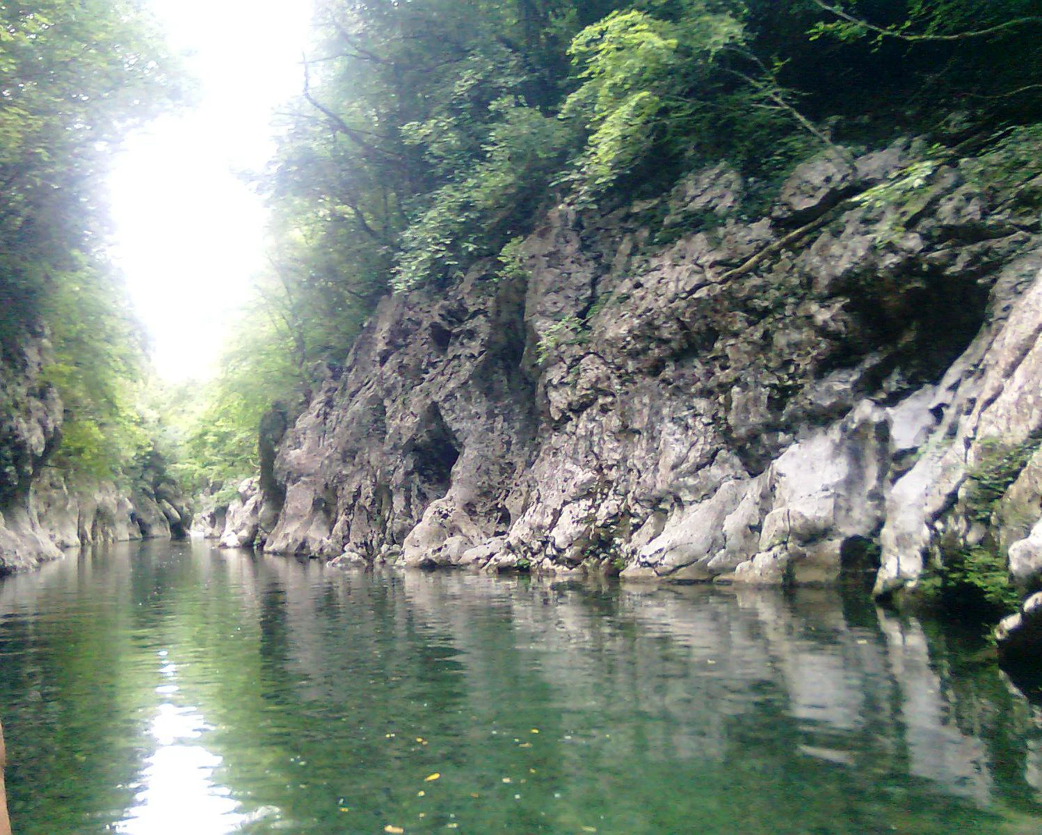
The wooded Calore gorge at Felitto

2

The Bussento emerging from its cave at Morigerati

3

Guided caves beneath the Alburni

4

Coastal walking towards Baia degli Infreschi

Green water between steep rock walls, with leafy trees above the narrow Calore gorge.

The Calore gorge at Remolino, photographed in July 2011. Trees overhang the water between the steep walls of the gorge.

File:Gole del calore remolino.jpg — Antonio Sabetta. Source: Wikimedia Commons. Public-domain release by author, with unrestricted-use fallback permission where dedication is not legally possible. No changes. · commons.wikimedia.org

Walks and routes

Calore gorge: Remolino to Magliano Nuovo

The park’s “Nel regno della lontra” itinerary runs from Remolino near Felitto to Magliano Nuovo: 8 km, about 5 hours, graded E for hikers, with 465 m of published elevation difference. It is a point-to-point description. Arrange your onward transport; do not mistake its figures for an 8 km return walk. The reward is the river’s narrow rock corridor and its historic crossings. Read the park route.

Uneven gorge terrain calls for sure footing. A visit to Remolino’s rest area is the lower-effort choice; it is not a verified wheelchair-accessible route.


Calore gorge: Remolino to Magliano Nuovo

Morigerati to the Bussento resurgence

The official route is listed as 1 km and about 1 hour, graded E. A stone mule track descends towards the cave, with narrow steps and small bridges along the approach. Allow a longer visit for the oasis and the climb back; the headline hour is not a complete door-to-door plan. Read the park route.

The descent, steps and uphill return rule out treating this as a level riverside stroll. Discuss mobility needs with the oasis before travelling.

Morigerati to the Bussento resurgence

Sentiero Italia CAI S02: Sanza to Rifugio Cervati

This mountain stage is 10.3 km with 1,103 m of ascent and 56 m of descent, ending at Rifugio Cervati rather than the summit. Treat it as a demanding one-way outing requiring a full plan for return or an independently confirmed overnight stay. Check the stage and its CAI link.

This is for walkers comfortable with sustained climbing and mountain navigation. A refuge name on a map does not establish staffing, beds, meals or drinking water.

Sentiero Italia CAI S02: Sanza to Rifugio Cervati

Sentiero degli Infreschi from Lentiscelle

CAI’s published coastal itinerary starts near the Grotta di Lentiscelle and reaches Baia degli Infreschi via the Pozzallo and Cala Bianca area. Its 2019 description gives 5 km and about 2 hours one way. Expect repeated climbs and descents through Mediterranean scrub, not a flat beach walk. Add the return and stops to your day. Read CAI’s description, page 17.

Natural surfaces and uphill sections require walking shoes and enough water. If considering a boat return, confirm that it will operate and where boarding is allowed before relying on it.

Sentiero degli Infreschi from Lentiscelle

Castelcivita: Percorso Turistico

For a shorter guided outing, choose the operator’s approximately one-hour tourist tour through chambers with stalactites, stalagmites and hanging formations. This is a distinct product from the four-hour amateur speleological visit. See the tourist tour.

Ask the operator about steps, surfaces and any support you need; the label “tourist” is not a step-free guarantee.

Castelcivita: Percorso Turistico

One focused day

Pick Felitto for a river day: check local conditions, choose either a short Remolino visit or a properly arranged longer walk, and leave time for the village. Alternatively, reserve a Castelcivita tour and keep the rest of the day flexible. Choose the pace that suits your group.

Three contrasting days

Use one day for a guided Alburni cave, one for Morigerati in dry weather, and one for the Camerota coast. Put the longest transfer on a flexible day and select accommodation accordingly. If mountain hiking is your main interest, replace the coast day with a locally confirmed Cervati plan; do not add it as an extra summit stop.

Things to try

Felitto and the Calore valley

Choose this area for rock walls, river scenery and a day that can stay close to one village. Remolino has a designated rest area and a nature trail. A short visit there is a different proposition from continuing all the way to Magliano Nuovo.

Morigerati and the Bussento

Here the main event is water returning to daylight after its underground journey. The combination of gorge, greenery and a stone mill makes a satisfying focused outing. Keep the day flexible: WWF closes the oasis when it rains.

Alburni cave gateways

Choose Castelcivita for an on-foot show-cave tour, or Pertosa-Auletta for the underground river. At Pertosa, Grotte Plus reaches the Grande Sala; Premium adds the Sala del Paradiso behind the underground waterfall and the Sala delle Spugne. The adjoining MIdA museums extend the story above ground.

Cervati or the Camerota coast

Sanza is the starting point for a substantial ascent towards Rifugio Cervati. Marina di Camerota gives access to the Infreschi coastal trail. Pick according to weather, fitness and transport, rather than assuming that a short distance on the map makes the two an easy same-day pair.

A changeable-weather day

Consider the MIdA museums on an open day, or ask whether the booked show-cave tour is operating. A cave is not automatically safe or open during severe weather, and Bussento explicitly closes on rainy days. Keep clear of gorges and follow Campania’s official weather alerts.

Wildlife and habitats

Eurasian otter — rivers and their quiet margins

The Calore is important otter country, and WWF also reports signs at Bussento. Quiet river margins connect these elusive mammals to the wider landscape; a guide may help interpret tracks without disturbing them.

Golden eagle — high mountain skies

High grasslands and mountain crags support golden eagles. The park also identifies rock partridge and Italian hare as part of this high-country food web.

White-throated dipper — flowing water

The park associates this bird with clear, well-oxygenated stretches of river. It gives river walks an avian focus alongside the much more elusive mammals.

Wolf — the wider mountain ecosystem

Camera traps have documented wolves in the park. Their presence says more about a functioning landscape than about what a day visitor should expect to see.

European wildcat — forest habitat

Forest-dependent European wildcats also appear in the park’s camera-trap records, including adults with young. They are part of the woodland ecosystem even when a walk reveals no obvious sign of them.

European beech — higher woodland

Beech forest is a defining part of the Gelbison–Cervati mountain landscape. Looking at the changing canopy is often more rewarding than expecting large mammals to appear.

Aleppo pine — coastal woodland

The park identifies Aleppo pine woods as characteristic of its coast. They form part of a Mediterranean vegetation mosaic that feels very different from the higher beech forests.

Stories and discoveries

A cliff flower as a park emblem

The Palinuro primrose, Primula palinuri, is the park’s emblematic plant. Its coastal cliff habitat is reason to admire it from a permitted path, never to climb towards or collect it. Flowering and visibility vary; this guide does not promise a particular display.

Water working out of sight

At Morigerati, the Bussento’s reappearance makes the idea of karst tangible: a river can leave the surface and continue underground. A show-cave visit adds a slower timescale, revealing formations built by water interacting with limestone.

When to visit

Spring

Choose a dry spell for gorge paths and lower coastal walks. Leave room for weather changes, and ask about conditions before treating the higher mountains as a summer hike.

Summer

Plan coast walks early and avoid making an exposed return climb the hottest part of the day. Carry your own water and arrange any boat leg in advance. A booked cave offers a cooler alternative.

Autumn and winter

Village and cave combinations are easier to adapt than a long through-hike. Check reduced opening schedules, rain-related oasis closures and mountain conditions. Shorter daylight needs to be included in your return plan.

Getting there and practical advice

Bussento booking and visitor centre

WWF lists a visitor centre, nature trail, equipped area and stone mill. Reserve via +39 333 6959991 or [email protected]. Its October schedule lists 10:00–17:00, with the final entry at 15:00; reconfirm for your date and weather. Ask the centre about facilities needed by your group.

Castelcivita tickets

Checked on 19 October 2026: the operator lists the tourist tour at €12 per adult. Its Italian October timetable differs from the English page, so call +39 0828 772397 for the actual slot and tour type. Download the operator’s English audio guide before entry if you want it; the caves have no Wi-Fi.

Pertosa-Auletta tickets and museums

Book with Fondazione MIdA at +39 0975 397037 or [email protected]. Its 2026 adult rates are €18 for Grotte Plus and €25 for Grotte Premium. Both include guided museum visits to use within 48 hours. The October–December cave schedule closes Mondays, and the museums also close Mondays. Check exceptions and availability before travelling.

Rail and the last leg

Agropoli-Castellabate, Vallo della Lucania-Castelnuovo, Pisciotta-Palinuro and Sapri are useful rail names to investigate for different parts of Cilento. Choose the station for your actual accommodation or excursion and arrange the connection onwards. Check the date-specific journey in Trenitalia, including the return.

An autumn 2026 transport check

From 1 October 2026, Trenitalia reports timetable changes caused by works between Vallo della Lucania and Agropoli, including earlier departures and longer journeys. Its advertised 2026 Cilento Link summer bus season has already ended. Do not rely on an old summer shuttle timetable for an autumn visit.

Driving to the right side of the park

The A2 Autostrada del Mediterraneo is the principal approach along the northern and eastern side. Battipaglia serves approaches towards the western coast; Sicignano and Petina are gateways for the Alburni; Sala Consilina and Padula are relevant for the Cervati side. Check the final local road and parking arrangements for your chosen site rather than navigating simply to “the park”.

Ask about the whole visit

MIdA describes horizontal, anti-slip cave paths, but its visit also includes boarding a boat. Ask which route suits your mobility, whether boarding assistance is available, and how the entrance, parking and toilets connect. Its approximately 15°C cave temperature also makes a jacket and closed shoes useful, even after a hot journey.

Sources and useful links

Wildlife you might spot

7

Each card links to a full Explore page with photos, traits, and fun facts.

Snap map for this place

Start with the big picture, then zoom in to explore individual wildlife observations around this place.

Loading map…

Good to know before you go

Choose your day’s destination before arranging transport; there is no single gateway that serves every landscape well.

Carry drinking water, a charged phone and offline route information. Tell someone your route and intended return time.

Wear footwear with grip. Smooth stone, damp steps and loose coastal paths deserve more care than beach sandals allow.

Book guided caves directly with their operators and reconfirm the start time shortly before travelling.

Watch animals from a distance, leave flowers and cave formations untouched, and keep to permitted paths and access points.

Frequently asked questions

Choose the one closest to your overnight base. Felitto suits a river-focused day; Morigerati offers a compact but stepped descent to a resurgence; Castelcivita or Pertosa-Auletta suits a booked cave visit. Save a coast-to-mountain combination for a longer stay.
A coastal base can work well with rail and a confirmed onward connection. Inland trailheads need more preparation. Arrange the last leg and the return before leaving your accommodation; a station named for a destination does not necessarily put you beside the beach or trail.
No. Castelcivita’s tourist tour is a walking visit among formations. Pertosa-Auletta includes a guided boat section on the underground river. Morigerati is an outdoor gorge walk to a river resurgence, with weather-related closure; it is not a sheltered rainy-day substitute.
Do not build the day around it. These are wild, elusive animals. River habitat, birds and woodland are more dependable reasons to visit. Signs interpreted by a knowledgeable guide can be rewarding without disturbing an animal or pursuing it.
Book and pay for the specific managed attraction or guided activity you choose. Caves have separate admission arrangements. On the neighbouring marine protected coast, boating, diving and other activities are subject to zoning and current permissions; a land excursion does not grant those permissions.
No. A beautiful pool is not a safety assessment or proof that bathing is permitted. Follow local restrictions and water conditions. At Baia degli Infreschi, the 2026 marine rules specifically exclude swimming from the restoration patch marked by red buoys.

Recent snaps at this place

Recent snaps will appear here as new observations are added.

View all ›

Take the discovery with you

Exploring Cilento, Vallo di Diano and Alburni National Park?

Identify the wildlife you spot, learn as you go, and keep a collection of the adventure.

  1. 1Spot it
  2. 2Snap it
  3. 3Keep the discovery















