
Snappit logo
Snappit
Get App
Generic illustration, not a photograph of this venueIllustration
ParkLa Rioja, Spain

Sierra de Cebollera Natural Park

Cebollera rewards a small plan and plenty of looking.

About

Cebollera rewards a small plan and plenty of looking. The upper Iregua runs through mountain woodland where pine, beech and oak give the slopes different colours and textures. Above them, rounded ridges and hollows preserve the shapes left by ancient ice. You can enjoy that larger story without setting out for a summit.

Start at the interpretation centre in Villoslada de Cameros. Its forest scenes and hands-on exhibits introduce the habitats you are about to enter. For a relaxed first visit, continue to El Achichuelo and use its adapted riverside trail, or choose the short natural-surface circuit at La Blanca. These are separate choices within the same park, with time left for a picnic and a proper pause beside the trees.

If everyone wants a longer walk, the signed Cascadas route from the Ermita de Lomos de Orios links pine woods, a former shepherds’ enclosure and the waterfalls of Puente Ra. It has climbs and uneven ground, so give it its own half-day rather than tacking it onto every other stop.

This is also a working cultural landscape. Seasonal livestock movements helped shape the open ground and woodland you see today. Across the park at Venta de Piqueras, the transhumance museum and Las Majadas trail tell that side of the story. Treat them as a different outing, especially if your visit starts with a morning in Villoslada. Eager to name that creature? Identify any animal you find during your visit using the Snappit app.

The park was created in 1995. Long before its protection, transhumant shepherds moved livestock between seasonal grazing grounds and left a landscape of routes, shelters and enclosures. As that way of life declined, woodland spread across some former grazing land. The visitor centre opened in Villoslada in 1999 and was renewed in 2021, including tactile and audio interpretation. The surviving glacial landforms tell a much older story, from cold periods when ice shaped the high valleys.

What to do here

Visit the Villoslada interpretation centre, choose one suitable trail, and stop to notice the woodland around you. El Achichuelo offers the clearest short-route option for visitors needing an adapted path; La Blanca adds a small forest circuit. Save the Puente Ra waterfalls for a longer walking day.

Seasonal info

Snow and ice can transform even a familiar path in winter. Heavy rain makes river edges and waterfall rocks hazardous; high winds are a reason to postpone a woodland walk. In autumn and winter, check the published hunt calendar for your chosen area as well as the weather and trail notices.

Accessibility

El Achichuelo has a specifically adapted 1.5 km return trail, with interpretation panels designed for wheelchair users and tactile/Braille information. Confirm its current surface, parking connection and available toilets before travelling. La Blanca and Las Majadas are natural paths, while Cascadas has climbs; their short distance or low difficulty rating does not make them wheelchair routes.

Don't miss

1

The Villoslada centre’s forest exhibits and tactile interpretation

2

The Iregua and woodland along El Achichuelo’s adapted trail

3

Puente Ra’s waterfalls on a properly planned longer walk

4

Pastoral history at Venta de Piqueras and Las Majadas

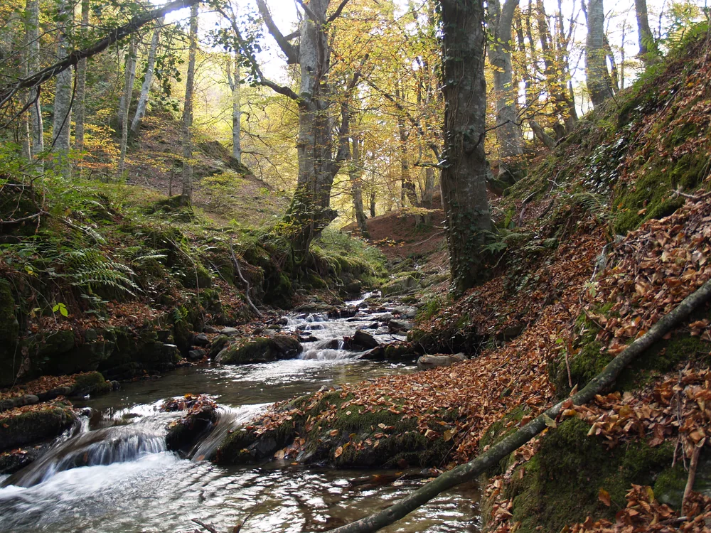
A small stream runs over rocks through autumn woodland, with moss-covered banks, exposed roots and fallen leaves beside the water.

A woodland stream at Achichuelo in Sierra de Cebollera, photographed in October 2007. The image shows the park’s river habitat, rather than a route or current path condition.

Arroyo en Achichuelo.jpg — Kapykua / Wikimedia Commons / CC BY-SA 4.0 · Creative Commons

Walks and routes

El Achichuelo: the short adapted trail

Start at the El Achichuelo car park. This linear trail follows the river-and-forest setting for 750 m each way, 1.5 km in total. Ten interpretation stops give you reasons to linger. The official time is 30 minutes; allow 45–60 minutes if you want to read, listen and take breaks.

The operator describes a level track suitable for mobility vehicles, with wheelchair-height, raised-relief and Braille interpretation. Ask about the current parking-to-path connection and any rough or wet sections.


El Achichuelo: the short adapted trail

La Blanca: a small woodland circuit

From La Blanca recreation area, follow the 1 km circular nature trail through the pine-and-beech setting beside the Iregua. The official guide gives 50 minutes and 20 m cumulative elevation, making this a good choice when you want to enjoy woodland without committing to the waterfall circuit.

Natural-surface footpath. Roots, leaf litter and wet ground can affect footing; ask about pushchairs and individual mobility needs rather than treating the low difficulty rating as an access guarantee.

La Blanca: a small woodland circuit

Cascadas: the longer waterfall walk

The signed 6.6 km circuit starts at the Ermita de Lomos de Orios and includes the Majada de las Desecadas and Puente Ra waterfalls. The official page gives two hours and 300 m cumulative elevation; allow 2½–3 hours with pauses. Use its route leaflet and the signs rather than improvising a shorter return.

A mountain-woodland walk on natural paths and forest track, with climbs and uneven footing. It is not an adapted route or a pushchair recommendation. Choose a shorter outing if the distance or conditions are too much.

Cascadas: the longer waterfall walk

Las Majadas: a different starting area

Begin and end at Venta de Piqueras. This 1.7 km circuit passes through beech and pine woodland and connects the landscape with the remains of pastoral life. The official estimate is one hour, with 10 m cumulative elevation. It pairs naturally with the nearby transhumance museum if its opening is confirmed.

Natural-surface path with a low official difficulty rating. Check ground conditions and any access requirements in advance; the museum and trail need separate access checks.

Las Majadas: a different starting area

A relaxed first visit from Villoslada

Give the centre around 30–45 minutes, ask which short trail is in good condition, then travel to El Achichuelo or La Blanca. Keep to one route and leave room for a picnic. The 2–3-hour overall allowance includes a modest transfer and pauses, but add time for a long lunch or a slower pace.

A waterfall half-day

Arrive at the Ermita de Lomos de Orios with enough daylight for the full circuit and unhurried stops. Take the official leaflet, food and water, and let the route itself be the main event. If conditions are poor, change to a suitable short route after asking the centre rather than seeking an unofficial shortcut.

A pastoral-history outing

Start at Venta de Piqueras, with museum opening checked beforehand. Combine the exhibits with Las Majadas and a break at the recreation area. This keeps the eastern side of the park coherent without adding a drive across to every Villoslada-area stop.

Things to try

Make the forest your subject

Choose a safe stopping place on the path and compare the shapes, light and colours around you. With children, try finding three different textures without collecting anything: bark, fallen leaves and a patch of moss are enough. A quiet few minutes can be more rewarding than another kilometre.

Follow a human story

At the waterfall route’s former shepherds’ enclosure, imagine the space needed for animals and the person looking after them. For a fuller cultural visit, choose Venta de Piqueras and Las Majadas on another outing. Leave gates as you find them and respect livestock and working land.

Look for a guided outing

The park links to the Pasea La Rioja programme. Check the current activity listing for a suitable place, date, language, meeting point and registration instructions. A booking for an activity is separate from deciding to walk a public trail independently.

Let the centre be the visit

When the centre is open, use its exhibits to explore the park’s forest and river habitats under cover. Do not substitute another woodland route automatically if wind, ice or heavy rain makes the first one unsafe. Venta de Piqueras offers a different indoor possibility only after its opening and the road conditions have been checked.

Wildlife and habitats

Scots pine

A useful tree to start with: compare the needles and bark of pines visible from the path with the neighbouring broadleaved trees. Leave cones and branches where they are.

Great spotted woodpecker

Listen during a quiet stop. The adapted trail account highlights woodpecker drumming, a good reminder that a forest visit can be about sounds as well as sightings.

Common crossbill

The park identifies crossbills among its pine-forest birds. Watch the canopy from the path with binoculars, giving any feeding birds space.

Roe deer

The park’s woodland supports roe deer. A quiet glimpse is a bonus; never follow an animal into cover, and keep dogs beside you.

Rosalia longhorn beetle

The La Blanca account links this beetle with old trees. Notice the value of ageing and dead wood without peeling bark, handling insects or moving fallen timber.

Wildlife comes and goes, and a quiet woodland walk is worthwhile even when animals stay hidden. Watch from established paths, avoid calls or playback, leave nests and shelters undisturbed, and do not share sensitive wildlife locations.

Stories and discoveries

The high hollows were shaped by ice

Cebollera’s cirques and valleys preserve glacial landforms even though the glaciers themselves have gone. Seasonal snow can fill those hollows again. Use the interpretation centre to understand them; seeing the geological story does not require adding an exposed mountain walk to your day.

Woodland can carry a grazing history

Some of today’s pine woods expanded after pressure from grazing declined. The sheltered forest is part of a changing landscape, shaped by both natural processes and people. Las Majadas makes that connection tangible through the remains of pastoral use.

When to visit

Spring and summer

Choose a mild day for the shorter trails and take time to notice new leaves, shade and water. Summer still calls for drinking water and protection from sun on open stretches. Check fire restrictions and leave the high mountain for a separate, properly equipped outing.

Autumn and winter

Autumn is a good time to compare the deciduous colours with the pine canopy. It is also a time to check hunting schedules and the park’s red-mite advice. Winter may bring snow or ice, shorter days and reduced centre hours. A short indoor visit can be the right plan when conditions rule out a walk.

Getting there and practical advice

Villoslada centre: practical details

The centre is on Carretera de Montenegro de Cameros, Villoslada de Cameros, where the road towards Lomos de Orio branches off. Admission is advertised as free. Call +34 941 468 216 or +34 690 180 513 during opening hours for route advice and specific access needs.

Centre opening through the year

Published mornings are 09:00–14:00: Thursday–Sunday and public holidays from 16 November to 21 March, and Tuesday–Sunday and public holidays from 22 March to 15 November. Friday and Saturday afternoons are added after the May holiday weekend to 30 June (16:00–18:00), in July–August (17:00–19:00), and from 1 September until after the November holiday weekend (16:00–18:00). December and Christmas holidays can have special arrangements; confirm your date.

Picnics, food and toilets

The park lists recreation areas at Achichuelo–La Blanca, Lomos de Orio and Venta de Piqueras, with parking and picnic tables. Bring drinking water and a cold lunch if you need certainty. Villoslada and Lumbreras have places to eat or stay, but check individual opening. Ask the centre where suitable toilets are available before heading to a trailhead.

The transhumance museum

The Centro de Interpretación de la Trashumancia is at Venta de Piqueras in the municipality of Lumbreras. Its displays explore shepherds’ travel, equipment and everyday life. The public page gives contact hours rather than a clear year-round admission calendar: phone the park centre before making a special trip.

Permits for other activities

Driving on restricted forest tracks requires permission. The official page and its linked MicoCebollera portal currently advertise a €1 vehicle permit; mushroom collecting has a separate permit and conditions. Check the eligible track, date, seasonal rules and current price before buying anything. These permissions are not a general park entrance ticket.

Driving to the right starting point

The park is south of Logroño, reached from the N-111 corridor. Villoslada’s interpretation centre is a useful first stop; El Achichuelo, La Blanca and Lomos de Orios have different starting points farther along the valley road. Venta de Piqueras is on the Lumbreras side. Follow official signs and avoid navigation shortcuts onto restricted forest tracks.

Using the regional bus

The VLR-115 Logroño–Montenegro de Cameros timetable was updated for 15 August 2026. Villoslada appears on the route, while Lumbreras and San Andrés are served by particular journeys. Days of operation and summer services differ, so check both directions for your date. The published timetable does not provide a shuttle to El Achichuelo or Lomos de Orios; arrange that connection or stay with a Villoslada-based visit.

Match the facilities to your needs

The Villoslada exhibition has Braille wayfinding, tactile elements and an audio-guide app following its 2021 renewal. Those resources do not establish every physical access detail. Call about entrance thresholds, circulation, seating and toilets, then ask separately about El Achichuelo’s current surface and parking connection. Explain your chair, walking aid or other requirements so staff can advise on the actual visit.

Sources and useful links

Wildlife you might spot

5

Each card links to a full Explore page with photos, traits, and fun facts.

Snap map for this place

Start with the big picture, then zoom in to explore individual wildlife observations around this place.

Loading map…

Good to know before you go

Choose your trail before leaving the centre. The short adapted El Achichuelo walk is different from the much longer Sendero del Achichuelo mountain circuit.

Check trail incidents, weather and the hunt calendar on the day. Respect closures, forestry work and hunting signs; ask staff for an alternative rather than passing a barrier.

Wear footwear with grip and carry water, food, a warm layer and rain protection. Allow time for stops and a return in daylight; do not rely on a phone connection for navigation.

At waterfalls, stay on the established path and keep children close. Wet rocks and fast water are poor places to step out for a photograph.

Drive only on roads and tracks open to public vehicles, and use designated parking. Restricted forest tracks need their own authorisation; a walking visit is not permission to drive farther into the park.

Take a cold picnic. Do not light a fire or use a barbecue just because an old picnic area has a grill; current fire restrictions and signs take priority. Carry out your litter.

Leave plants, fungi and dead wood in place. Mushroom collecting is regulated and requires the relevant permit in regulated woods; a vehicle permit does not cover collecting.

Keep dogs close and on a lead around wildlife, livestock and other visitors, and ask about indoor admission separately. In autumn, use the park’s tick and red-mite advice when choosing clothing and checking after a walk.

Frequently asked questions

At the Sierra de Cebollera interpretation centre in Villoslada de Cameros, on Carretera de Montenegro. Check that it is open, then choose El Achichuelo or La Blanca for a short outdoor visit. Venta de Piqueras is a separate starting area on the other side of the park.
The Villoslada centre advertises free admission. Check registration for scheduled guided activities with Pasea La Rioja. Ordinary published walking routes are presented as self-guided outings; organised groups and special activities should check their requirements with the park. Restricted-track driving and mushroom collecting have separate permits.
It is a 6.6 km mountain-woodland circuit with 300 m of cumulative elevation change on the official route page. The published walking time is two hours, but allow longer for stops. Uneven ground, uphill sections and slippery conditions make it a different proposition from a short riverside stroll.
Ask specifically about the adapted El Achichuelo trail and the connection from its car park. It is 750 m each way. Confirm current surfaces, turning space, assistance needs and toilets with the centre; do not assume the waterfall circuit or other natural paths offer the same access.
The regional Logroño–Montenegro de Cameros service includes Villoslada, with other journeys serving Lumbreras and San Andrés. The timetable varies by day and season. Plan the return first, and make a centre-and-village visit unless you have arranged onward transport to a woodland trailhead.
Treat the summits as a separate mountain day. The park warns that high-level approaches are not clearly waymarked paths and are for suitably equipped people with mountain experience. Snow, wind and poor visibility can make them demanding even when the valley feels mild.

Recent snaps at this place

Recent snaps will appear here as new observations are added.

View all ›

Take the discovery with you

Exploring Sierra de Cebollera Natural Park?

Identify the wildlife you spot, learn as you go, and keep a collection of the adventure.

  1. 1Spot it
  2. 2Snap it
  3. 3Keep the discovery











