Snappit logo
Snappit
Get App
Generic illustration, not a photograph of this venueIllustration
ParkCastilla-La Mancha, Spain

Alto Tajo Natural Park

Alto Tajo rewards a slower kind of day out.

About

Alto Tajo rewards a slower kind of day out. The river and its tributaries cut through pale limestone and red sandstone, while pine woods cover slopes and junipers occupy the higher plateaus. On a walk, the interesting change may be just around a bend: a dry, sunny hillside gives way to a cool ravine with hazel and other broadleaved trees. Look up as well as down; the cliffs are habitat for large birds of prey.

Use Peralejos de las Truchas as your first-visit base. Its seasonal park information point can help you choose a walk and check roads, parking and river conditions. For a gentler family outing, combine that stop with the 2.8 km Piedras Rojas circuit at Chequilla, reached separately by road. White village walls, reddish rock towers and patches of woodland give children plenty to notice without committing to a gorge hike. Keep them close on the circuit’s opening paved section, which is shared with vehicles.

Confident walkers can instead devote their outing to Barranco del Horcajo near Peralejos. It is a medium-grade, 6.5 km circuit with a narrow ravine path and a steep descent. Salto de Poveda and Laguna de Taravilla are another separate choice, with more complicated seasonal parking and crossings. Resist collecting all three in one day: road transfers, family stops and changing conditions matter as much as the kilometre figures. Take the ultimate field guide with you: use the Snappit app to identify birds, plants, and animals on your trip.

The park was declared by Law 1/2000, protecting a landscape whose identity comes from rivers, woodland and the people who used them. Timber was once moved downstream by gancheros, skilled workers who guided logs through difficult water. José Luis Sampedro’s novel El río que nos lleva helped bring that working river to a wider audience. Grazing, resin collection, salt production and forestry have also left marks on the landscape. Geological interpretation now helps visitors read a much older story in the rocks. Alto Tajo Natural Park overlaps the larger Molina–Alto Tajo UNESCO Global Geopark, but the two names refer to different areas and should not be used interchangeably.

What to do here

Begin at the Peralejos information point when it is open, then choose one walk. Chequilla offers a shorter red-rock circuit; Horcajo gives a longer woodland-and-ravine experience. At any safe stopping place, spend a few minutes comparing rock shapes, tree leaves and the birds moving above the cliffs.

Seasonal info

Summer brings parking reservations in the central canyon and possible vehicle restrictions, as well as heat and fire risk. Spring rain can affect crossings; winter brings short days, frost and icy stretches. The published Peralejos 2026 opening calendar finishes on 20 September, so an autumn or winter visit needs a different confirmed information arrangement.

Accessibility

The operator lists the Peralejos information point as accessible, but confirm its entrance, toilets and opening for your needs. That does not make the surrounding trails accessible. Chequilla is low difficulty but includes vehicle-shared pavement and unpaved tracks; Horcajo has a narrow path and steep descent. Salto de Poveda has uneven terrain and unprotected crossings. Ask about a suitable short experience before travelling with a wheelchair, mobility aid or pushchair.

Don't miss

1

Peralejos de las Truchas

a practical village base and seasonal park information point.

2

Chequilla’s Piedras Rojas

a short circuit among red rock formations and pine woodland.

3

Barranco del Horcajo

cool ravine vegetation and a more demanding view of the river landscape.

4

Cliff and woodland wildlife

slow down for soaring raptors, bird calls and changing tree communities.

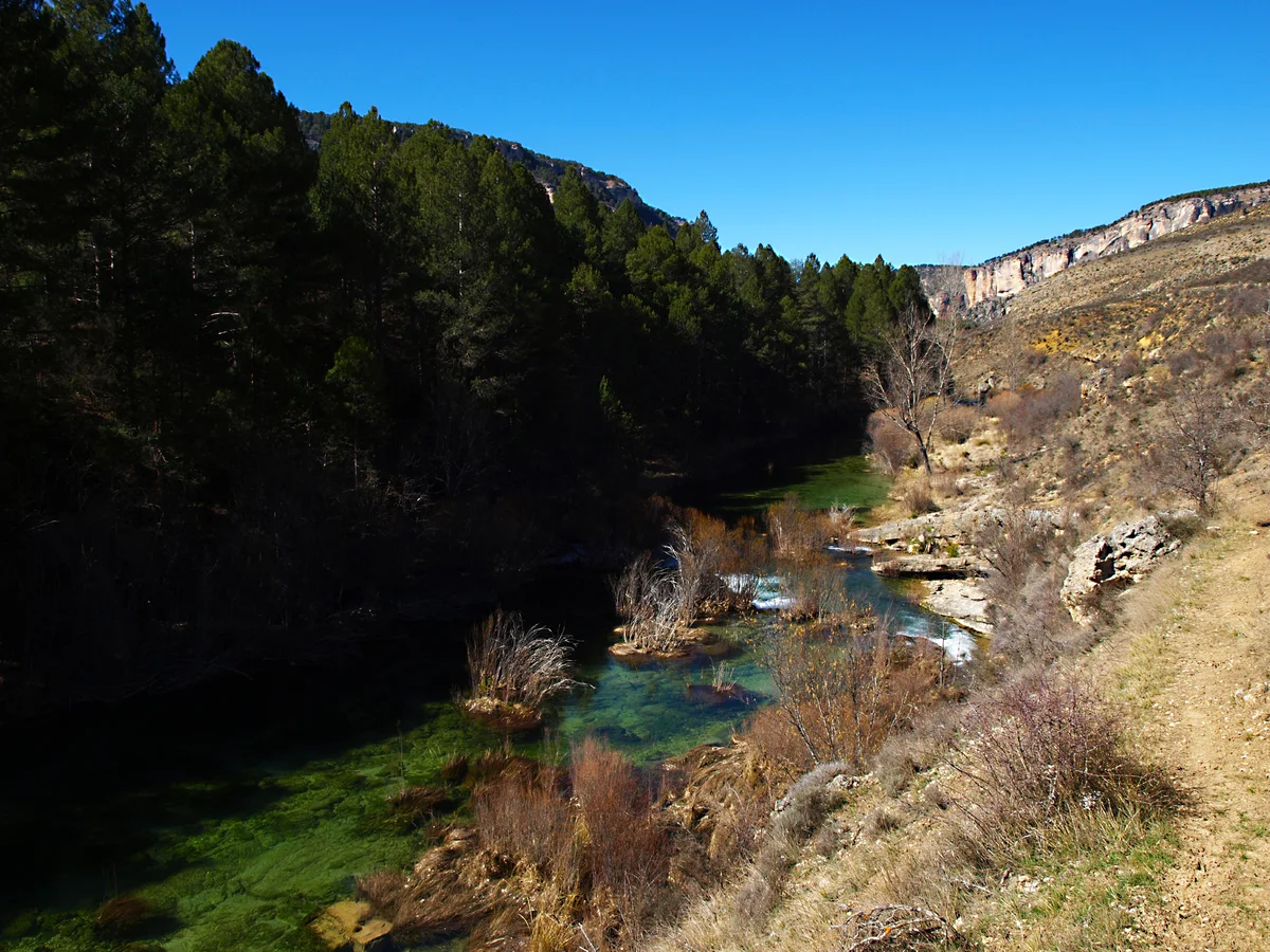
Green river pools between a deeply shaded pine-covered bank and sunlit rocky slopes near Peralejos de las Truchas.

The River Tagus near Peralejos de las Truchas in Alto Tajo Natural Park, photographed in March 2015.

Río Tajo en Peralejos de las Truchas.jpg — Olisacu / Wikimedia Commons / CC BY-SA 4.0 · Creative Commons

Walks and routes

Piedras Rojas, Chequilla: the shorter family choice

The signed SL-GU 01 circular walk starts on the outskirts of Chequilla toward Peralejos and runs anticlockwise. Follow white-and-green marks. After about 800 metres on a paved lane, it turns onto a forest track and loops past red sandstone and conglomerate formations around the village. Allow 90 minutes to two hours with stops.

Official route: 2.8 km circular, about one hour of walking.

Officially low difficulty. The first 800 metres share a paved lane with vehicles; keep children close. Later sections are unpaved. Ask about current surfaces before using a pushchair or wheelchair.


Piedras Rojas, Chequilla: the shorter family choice

Barranco del Horcajo: a longer ravine walk

Start from the signed track off the CM-2016, about 2 km beyond Puente del Martinete toward Tragacete. The operator recommends a clockwise circuit. Follow the Horcajo signs where the route meets GR-66; do not take the Cueva del Hierro branch. Pine woodland leads into a narrow limestone ravine before the path returns above the Tajo. Allow 3–4 hours including pauses.

Official route: 6.5 km circular, about three hours of walking.

Officially medium difficulty, with a narrow ravine path and a steep descent. It is a choice for walkers comfortable on uneven ground, rather than a default outing for small children or wheels.

Barranco del Horcajo: a longer ravine walk

Salto de Poveda and Laguna de Taravilla: a separate canyon day

The official Sendero 10 links the waterfall landscape and lagoon in a 5 km circuit. Choose the current permitted approach and parking before travelling; the 2026 park notice directs full-circuit walkers to P2 on the Poveda side. This is distinct from the longer 15 km Georuta 7. Allow 3–4 hours with stops, plus access time.

Official route: 5 km circular. The park page gives two hours in its headline and at least three hours in its duration category; allow 3–4 hours with stops.

Officially medium difficulty. The operator warns of uneven drops, unprotected footbridges and a ford, with sections unsuitable for reduced mobility. Close supervision of children and grippy footwear are essential; choose another outing if anyone is uncomfortable with these barriers.

Salto de Poveda and Laguna de Taravilla: a separate canyon day

Gentler half-day: Peralejos and Chequilla

Confirm the information point is open, then allow about 20–40 minutes to ask questions and orient yourselves. Travel separately by road to Chequilla and spend 90 minutes to two hours on Piedras Rojas. Leave time for a village meal or your own picnic in a permitted place. If Peralejos is closed, obtain the advice beforehand and start directly at Chequilla.

Walking half-day: Horcajo

Get the current route advice before leaving Peralejos. Reach the signed start by the CM-2016 and allow 3–4 hours for the clockwise circuit. Carry lunch and water, set a comfortable turnaround decision before committing to the ravine, and return with daylight to spare. Skip an extra gorge or waterfall transfer afterwards.

A second day in the central canyon

Choose Salto de Poveda only after checking crossings and the seasonal parking system. Reserve the correct area where required, save the ticket, and allow extra time for the forest-track approach. Walk the official circuit only if every member of the group is comfortable with its exposed and uneven sections.

Things to try

A five-minute landscape detective game

At a safe stopping place, ask everyone to find three colours, two different leaf shapes and one sign of moving water. Take a photograph of red rock at Chequilla to compare later with the pale limestone cliffs elsewhere. Looking closely is more useful than collecting specimens.

Binocular pauses

Choose a firm spot away from the path edge, then scan the sky and listen to the woodland for a few quiet minutes. Let children take turns with binoculars while an adult watches the immediate surroundings.

Interpretation before a walk

Use the seasonal Peralejos information stop to ask which route best fits your group. For a more substantial indoor introduction on a different day, Dehesa de Corduente covers water, woodland, geology and traditional uses.

A guided nature outing

Ask the park about current guided walks and the Vive Tu Espacio programme, checking dates, meeting point, language, price and booking. Organised groups and specialist river activities may need authorisation; arrange those through the park or an authorised operator.

Book an indoor introduction

If you can confirm an opening, make Dehesa de Corduente’s interpretation displays the main activity. It is in another sector, so plan the road journey rather than assuming it is next door to Peralejos.

Change the day, not the crossing

After heavy rain, or during thunderstorms, strong wind or icy weather, postpone gorge paths and river crossings. Spend time in a village or use a confirmed indoor activity. A shorter route is useful only if its own conditions are safe.

Wildlife and habitats

From a safe path-side stop, scan the sky for large birds circling with broad wings. Use binoculars instead of approaching a cliff or nesting ledge.

Cliff skies

Compare a large bird’s outline and wing shape through binoculars. Keep an identification tentative if the bird is distant; a brief silhouette is a useful starting point.

Large raptors at a distance

Watch for the faster flight and more pointed wings of a falcon, without searching cliff recesses or approaching a perch.

A different flight shape

During the warmer part of the year, compare any smaller vulture with the larger griffons. Watch quietly from a public path; nest-finding is not part of the outing.

Seasonal vulture interest

An otter is an elusive possibility, not a reason to leave the path. Look at the sheltered river margins from a safe position and talk about why clean water and connected banks matter.

Understand the river habitat

Pause and listen where a public trail meets woodland. If a deer appears, stand still and give it an easy escape rather than following it.

Quiet woodland edges

Look for orange-toned bark higher on mature Scots-pine trunks and compare their appearance with other pines. Observe from the path and leave cones and branches in place.

Read the pine woodland

Notice the change from pine needles to broad, rounded hazel leaves in damper woodland. Photograph the plant without leaving the path or collecting nuts.

A cool-ravine tree

Compare a yew’s flat needles with nearby pine foliage when one is visible from the route. Do not taste or collect any part of the tree.

Evergreen variety

Wildlife varies with season and conditions, so enjoy the habitats as well as any animals you notice. Watch from public paths, keep a respectful distance, never feed wildlife or play calls, and avoid searching for nests, dens or sensitive plants. No particular sighting is guaranteed.

Stories and discoveries

The waterfall also tells a human story

Salto de Poveda formed after the wall of an old hydroelectric dam failed. Its present appearance combines flowing water, rock and earlier engineering. View it from the authorised path and platforms.

Different rocks, different shapes

The park includes both limestone gorges and red-sandstone landscapes. Chequilla’s towers and the pale walls of Horcajo offer two very different ways to see weathering and erosion at work.

Cool pockets of woodland

Sheltered ravines support broadleaved trees among a much wider pine-dominated landscape. That change of vegetation is a clue to local shade and moisture, not simply a change in altitude.

The working river

Gancheros guided timber downstream through the Tajo’s difficult reaches. Their craft is part of the area’s identity and the setting of El río que nos lleva.

When to visit

Spring

Enjoy fresh woodland and flowing water, but check the forecast and crossings after rain. A short Chequilla walk may suit a changeable day better than committing to a gorge. Peralejos opens only on selected calendar dates.

Summer

Reserve central-canyon parking where required, start walks before the hottest part of the day and carry enough water. Check fire and road restrictions. The 2026 rules are a useful warning to plan ahead, not a promise of next summer’s dates.

Autumn

Broadleaved trees add colour and cooler days suit walking. Keep a warm layer and enough daylight for the return. Peralejos’ published 2026 calendar has no opening dates after 20 September, so arrange advice in advance.

Winter

Choose short outings only when the forecast, roads and paths suit your group. Frost, ice and shorter daylight make a ravine walk a different proposition. Confirm any indoor visit instead of expecting a seasonal information point to be open.

Getting there and practical advice

Peralejos information point

Find it on Calle del Arroyo de Arriba. The operator lists +34 648 587 394 for Wednesday–Saturday contact and +34 648 587 184 on opening days; email [email protected]. Check the attached calendar for the actual building opening. Ask staff which interpretation materials and local route advice are available.

Dehesa de Corduente interpretation centre

This is the main park interpretation centre in the northern sector, at kilometre 85 of the CM-2015, about 2 km from Corduente. It has displays about habitats, geology and traditional uses, plus an adjacent recreation area with tables, benches and children’s play equipment. Confirm its own calendar before using it as an alternative.

Toilets, water and food

Plan these in the village before walking and ask which facilities are available on your date. The 2026 canyon notice announced dry toilets at Puente de San Pedro and Laguna de Taravilla; ask whether they are open for your visit. Carry your own water and do not assume a marked spring is potable.

Parking

Use only signed, authorised spaces and leave access clear. A small trailhead parking area is not guaranteed to have room. Central-canyon parking has its own seasonal reservations; it is separate from finding a place in Peralejos or Chequilla.

Choose the gateway before navigating

Set your destination to Peralejos de las Truchas, Chequilla or the named trailhead, rather than a generic park pin. The park stretches across Guadalajara and Cuenca and has multiple approaches. The visitor guide gives access options from Guadalajara, Molina de Aragón, Cuenca and Teruel.

Horcajo’s road approach

The official start is off the CM-2016 toward Tragacete, around 2 km from Puente del Martinete. Use the start link on the current route page and local signs. On foot, follow the signed final path back to the start rather than walking the road.

Forest tracks and restricted through-access

Check which approach reaches your chosen central-canyon parking area. Do not use the Poveda–Peñalén–Zaorejas track as an assumed through-road: seasonal restrictions affect the El Vivero–La Falaguera section. Drive slowly, keep emergency access clear and follow any temporary barrier.

Without a car

Confirm a current service, taxi or accommodation transfer to the precise starting point, together with a reliable return arrangement. Ask the park or your accommodation whether a current service reaches the walk you have chosen. Make those arrangements before reaching an area with weak reception.

Peralejos building access

The official listing marks the information point as accessible. Ask about the complete approach, entrance, usable toilets, seating and any help you require, and confirm an opening date. A general accessibility flag does not describe every facility.

Walking-route choices

Chequilla is shorter and low-grade, but has a vehicle-shared paved beginning and unpaved later sections. Horcajo’s narrow path and steep descent and Salto de Poveda’s exposed crossings are significant barriers. Request an alternative that suits your group rather than treating route difficulty as an accessibility rating.

Adapted hiking-chair loan

The park offers a Joëlette from Dehesa de Corduente, subject to approval, route suitability and weather. It requires at least two fit companions; additional helpers are recommended for relief. Apply at least a week ahead to [email protected] and agree the route, support and collection arrangements. The existence of this service does not make every trail suitable.

Closer parking at Salto de Poveda

The 2026 notice identifies P4 as a closer parking option for visitors with reduced mobility. Ask the park and booking service how to arrange it and what is reachable from there. A closer parking space does not remove the trail’s uneven ground or unprotected sections.

Peralejos seasonal opening

The published 2026 calendar marks selected dates in April and June–September. Opening is 10:00–15:00, with 16:00–18:00 added on green-marked days. The final marked date is 20 September. Check the calendar and contact the park for your exact visit; generic Friday-to-Sunday centre hours elsewhere do not establish this information point’s opening.

Canyon reservations and dates

The municipal site advertised paid reservations from 27 June to 31 August in 2026, while the park notice’s title used 26 June–30 August. Check the applicable dates for your trip and do not assume later seasons repeat them. The booking page says completed reservations cannot be cancelled or refunded; check current charges before paying.

Temporary route and road notices

Recheck the specific route, current park notices and local signs. The Salto de Poveda page reported the Pescadores crossing operational when checked on 17 October 2026, but changes in water can affect it again. Check current track restrictions rather than relying on the dates of a past event closure.

Independent visits and organised groups

The visitor guide allows individual walking without a general park permit, subject to restrictions. Organised groups and bus visits should arrange the required park authorisation in advance. Parking bookings, specialist activities and centre arrangements are separate questions.

Respect the place

Leave plants, wildlife, fossils and rocks undisturbed, take rubbish away, keep noise low and follow signs. Use a picnic that needs no flame; do not set up camp. Check current fire restrictions and keep dogs on a lead in intensive-use visitor areas.

Sources and useful links

Wildlife you might spot

9

Each card links to a full Explore page with photos, traits, and fun facts.

Snap map for this place

Start with the big picture, then zoom in to explore individual wildlife observations around this place.

Loading map…

Good to know before you go

Check the exact centre calendar, route notice and weather before leaving. Download directions and save any parking ticket offline; mobile coverage is poor in much of the canyon.

Choose one walking area for the day. A narrow canyon road or forest track is a slow transfer, and the few bridges make places on opposite banks less close than they look.

For a lighter family walk, choose Chequilla’s 2.8 km circuit and watch for cars on the first 800 metres. Horcajo and Salto de Poveda deserve a more careful assessment of every walker’s ability.

For a summer canyon visit, reserve the correct parking area before driving in. Check the current season’s dates and terms; arriving early does not replace a required reservation.

Wear shoes with grip and carry water, food, sun protection and a warm or waterproof layer. Do not rely on a fountain being drinkable or a seasonal café being open.

Keep children beside you near drops, water and footbridges. Never use a bridge as a diving platform, and turn back if a crossing or path is unsafe.

Use signed parking and public paths, keep dogs on a lead in busy visitor areas, leave plants and rocks in place, and take all litter back to a village bin.

Bring a picnic that needs no flame, and follow fire restrictions and staff instructions. In an emergency call 112, but plan your return and share your route beforehand because a phone may not connect.

Frequently asked questions

Use the Peralejos de las Truchas information point on Calle del Arroyo de Arriba if its calendar matches your visit. It is a seasonal facility. Confirm opening before making a special trip; Dehesa de Corduente is the park’s main interpretation centre in a different sector.
The official Piedras Rojas circuit at Chequilla is 2.8 km, low difficulty and about one hour of walking. Allow 90 minutes to two hours with children and stops. Its first 800 metres share a paved lane with occasional vehicles, and low difficulty does not mean wheelchair accessible.
Treat it as a proper walk. The current park page rates the 6.5 km circuit medium and gives three hours. There are narrow sections and a steep descent. Older leaflets describe a shorter, easier outing, so use the current route page and assess the children and conditions before committing.
General park access is listed as free. Seasonal canyon parking is a separate paid reservation, and guided activities can have their own charges. Check the chosen parking area’s current total and cancellation terms before paying.
Check the current season on the municipal booking site. Its 2026 window was 27 June–31 August, while the park’s 2026 notice used slightly different dates. Reservations applied on weekdays as well as weekends. Save the ticket before entering the canyon, where reception is poor.
Do not assume the forest track is open as a through-route. In summer 2026, the El Vivero–La Falaguera section had motor-vehicle restrictions from Friday to Sunday in July and August, plus 10–17 August. Check the latest notice and use the permitted approach to your booked parking area.
For this outing, enjoy the river from the path. A parking ticket is not a swimming-safety assessment. Never jump from bridges or approach the waterfall lip. If you want a water-based activity, ask the park about current permitted areas and conditions and use an authorised provider where appropriate.
Keep it under control throughout the visit and on a lead in intensive-use visitor areas. Carry water for it, keep it away from wildlife and livestock, and ask about the exact route and any assistance-dog arrangements when checking access.
Arrange transport to the exact village or trail start and confirm the return before travelling. Check any village service’s timetable and onward connection to the walk; do not assume it reaches the trailhead. Ask the park or your accommodation about current local options rather than relying on a general park destination in a journey planner.
No. This guide covers the natural park in Guadalajara and Cuenca. The wider Molina–Alto Tajo UNESCO Global Geopark contains other places and geological sites beyond this park. Peralejos and the named walks are visit choices within that larger regional context.

Recent snaps at this place

Recent snaps will appear here as new observations are added.

View all ›

Take the discovery with you

Exploring Alto Tajo Natural Park?

Identify the wildlife you spot, learn as you go, and keep a collection of the adventure.

  1. 1Spot it
  2. 2Snap it
  3. 3Keep the discovery