Snappit logo
Snappit
Get App
Generic illustration, not a photograph of this venueIllustration
ParkCastilla y León, Spain

Hoces del Río Riaza Natural Park

The Riaza gives this quiet corner of north-eastern Segovia several different faces.

About

The Riaza gives this quiet corner of north-eastern Segovia several different faces. Around Maderuelo it spreads into the Linares del Arroyo reservoir; below the dam it cuts through limestone, and towards Montejo de la Vega the valley opens into farmland. Dry uplands, juniper woodland, rock walls and a green ribbon of riverside vegetation sit surprisingly close together.

For a first visit, make Montejo de la Vega de la Serrezuela your base. Start at the Casa del Parque, then follow the short Fuente de la Pisadera circuit if conditions suit your group. A wooden crossing over the river, the nearby cliffs and a spring-fed recreation area give you plenty to notice without committing to the longer gorge walks. Leave time to stop rather than treating the distance as a target.

The birds are a big part of the appeal. Griffon vultures use the park’s cliffs, and watching a broad-winged bird turn overhead can hold everyone’s attention for several minutes. The refuge at Montejo also has a remarkable conservation history, built on cooperation between local people and naturalists. Bring binoculars, stay on the path and let the birds carry on with their day.

If you want to explore further, choose one outing that fits the weather and your walking experience. Entre Puentes stays around the lower valley; Valdevacas offers upland paths and the more demanding Casuar circuit; the Senda del Río is a substantial canyon walk. Some reserve-zone routes need permission during the breeding season. The short visit is rewarding in its own right, so there is no need to turn it into a long hike on impulse. Turn your visit into a safari! Use the Snappit app to scan and log wildlife sightings here.

The landscape holds several layers of human history, from farming and sheep husbandry to the ruined Romanesque church of San Martín del Casuar. The Linares del Arroyo reservoir changed the upper valley in the mid-twentieth century. These are working rural surroundings as well as a protected landscape. Montejo’s bird refuge was officially inaugurated on 13 January 1975, following work by Félix Rodríguez de la Fuente, WWF/ADENA and local people. Its purpose included protecting the cliff-nesting raptors, especially griffon vultures. The wider Hoces del Río Riaza area became a natural park in 2004. That history helps explain why a considerate visit matters: wildlife protection and local livelihoods have developed together here.

What to do here

Visit the Casa del Parque, then take the Fuente de la Pisadera loop for river views, a quiet birdwatching pause and a rest at the recreation area. For a longer day, choose a separately planned route from Montejo or Valdevacas after checking access with the centre.

Seasonal info

The published permit season for the reserve-zone Senda del Río and Ermita del Casuar routes is 1 January–31 July, with a maximum group size of 10 people. Obtain the required authorization from the Casa del Parque and check the exact route before travelling. Outside that period, current barriers, conservation restrictions, weather and path conditions still apply.

Accessibility

Fuente de la Pisadera is the strongest starting option for a wheelchair or pushchair: the park describes the 1.965 km circuit as adapted, on compacted gravel, with a maximum gradient of 6%. It includes a wooden river crossing and a stretch shared with vehicles. Check the current surface, bridge access and facilities with staff. Only part of Entre Puentes is described as accessible; the canyon routes involve slopes and narrower paths.

Don't miss

1

A short river-and-spring circuit starting beside the Casa del Parque

2

Griffon vultures in flight above the valley and cliffs

3

The contrast between dry juniper country and riverside greenery

4

A conservation story rooted in the people of Montejo and its bird refuge

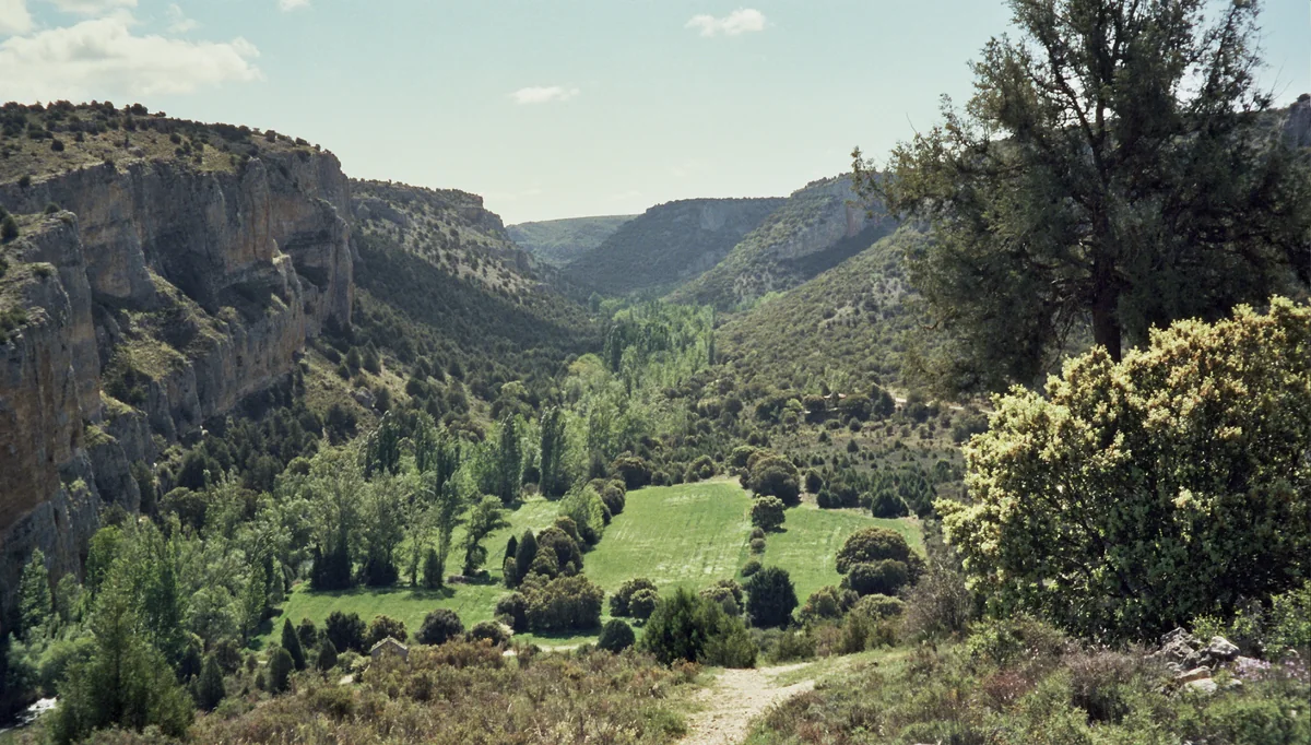
A green valley with fields and rows of trees lies between steep pale cliffs, with shrubs and a descending earth path in the foreground.

The Río Riaza gorge at Montejo de la Vega de la Serrezuela, photographed in 2003. Cliffs frame a green valley floor.

ReservaMontejoDeLaVegaDeLaSerrezuela2.jpg — Rowanwindwhistler / Wikimedia Commons / CC BY-SA 3.0 Unported · Creative Commons 1 · Creative Commons 2

Walks and routes

Fuente de la Pisadera: the first-visit loop

Start beside the Casa del Parque and follow the signed circular path through the planted area and across the wooden river bridge. Continue beside the Riaza towards the spring and recreation area, then complete the signed return. The official distance is 1.965 km. Allow 45–75 minutes for a relaxed walk with looking and resting stops; a centre visit is extra.

Compacted gravel; officially described as adapted, with a maximum gradient of 6%. There is a wooden river crossing and a vehicle-shared stretch. Check surface firmness, bridge access and current barriers with staff. The recreation facilities have differing levels of accessibility.


Fuente de la Pisadera: the first-visit loop

Entre Puentes: a longer lower-valley walk

PRC-SG-5 follows the agricultural valley from Montejo and crosses the river on its signed circuit, with views of the cliffs and farmland. The route page gives 6 km and about two hours; a leaflet panel gives a shorter figure, so ask staff which starting point and circuit to follow. Allow 2–3 hours including pauses once the day’s route is confirmed.

Only part of the route is described as suitable for wheelchairs and pushchairs. Ask staff to identify that section and a suitable turnaround rather than assuming the full loop is adapted.

Entre Puentes: a longer lower-valley walk

Cerro Alto: a short climb from Valdevacas

PR-SG-8 climbs from Valdevacas de Montejo to a viewpoint over the surrounding countryside. The published distance is 750 m each way, or 1.5 km out and back. Allow 30–60 minutes including a pause by the interpretation panels and benches, then return along the same signed path.

This is an uphill forest track, not the adapted riverside circuit. Judge the surface and climb against your group’s needs; a short distance does not mean a level walk.

Cerro Alto: a short climb from Valdevacas

Ermita del Casuar: a half-day canyon circuit

PRC-SG-7 starts and ends at Valdevacas, passing juniper country and traditional sheep shelters before entering the canyon landscape and the area of the ruined church. It is roughly 10 km, with the leaflet recording 361 m of ascent and the same descent. Allow 4–5 hours with breaks, and check the exact signed itinerary and access around the ruins before setting out.

Includes slopes, a narrower path and a descent into the valley followed by the return climb. This is a more demanding hike, unsuitable as a substitute for Pisadera when a step-free route is needed.

Ermita del Casuar: a half-day canyon circuit

Senda del Río: the long canyon outing

PR-SG-6 runs from the Montejo area through the canyon towards the foot of the Linares del Arroyo dam, returning along the same route. Plan it as a full day: official return figures are around 20 km or more, with around eight hours of walking. Published one-way and return distances are inconsistent, so agree the start, turnaround and total commitment with staff rather than combining figures from different panels.

Agricultural tracks give way to narrower sections and slopes. Carry enough food and water for a long return on foot; it is not a wheelchair route or an easy extension to the short centre visit.

Senda del Río: the long canyon outing

Tenadas de Valdevacas: upland farming and woodland

PRC-SG-9 is a circular walk from Valdevacas through fields, juniper and oak country, passing the sheep shelters that give it its name. Published descriptions put it at roughly 5 km. Allow 1½–2½ hours with stops after confirming the current start and signed loop. It offers a different view of the park from the river walks.

Unsealed paths and slopes, with no whole-route adapted designation. The operator discourages cycling on this route.

Tenadas de Valdevacas: upland farming and woodland

Linares del Arroyo reservoir: plan the Maderuelo route with staff

PRC-SG-10 explores the reservoir side from Maderuelo. Before choosing it, ask the Casa del Parque for the current signed itinerary: the website gives 10 km and four hours, while its linked leaflet describes a 4 km loop. That difference is too large to plan around casually. Choose a confirmed route and return time, then enjoy the open-water landscape from the established path.

The older leaflet describes the first approximately 1 km to the La Rivilla recreation area as accessible, but it does not certify today’s surface or a complete accessible loop. Check that specific stretch with staff.

Linares del Arroyo reservoir: plan the Maderuelo route with staff

An unhurried first morning

Arrive for the Casa del Parque’s opening period, get current path advice and spend roughly 30–45 minutes with the exhibits. Add 45–75 minutes for Pisadera, plus a rest if you wish. This suggested 1½–2½-hour outing leaves room for children to stop and look. Skip the loop if the crossing or surface is unsuitable that day.

A longer walk from Montejo

If everyone wants more walking, choose Entre Puentes as the main walk rather than automatically adding it to Pisadera. Confirm the circuit and accessible section at the centre, then allow a relaxed 2–3-hour walking slot with water and snacks.

Choose one Valdevacas outing

For a short climb, select Cerro Alto. For upland fields and sheep shelters, consider Tenadas. For a more strenuous half-day, plan Casuar with its permission and site-access checks. Pick one according to the weather and your group’s ability rather than trying to link the routes without a plan.

Give the full canyon its own day

Arrange any permission before travel, confirm the exact Senda del Río return trip and start early enough to finish in daylight. Carry the map offline and enough supplies for the full walk. If that commitment does not suit the group, make a shorter planned visit instead.

Things to try

Start with one question at the centre

Ask how the river made the gorge, why vultures use the cliffs, or which walk fits your group today. The exhibits connect the landscape and its wildlife; the audiovisual offers a useful indoor introduction.

Try a patient skywatch

Pause somewhere safe without blocking the path and spend a few minutes watching one bird rather than chasing every movement. Notice how little a soaring vulture needs to flap. Keep binocular straps secure on bridges and supervise children using them.

Compare two habitats

On a short walk, notice where the vegetation changes from the river margin to drier ground. Ask children to find contrasting colours, leaf shapes and textures while leaving everything in place.

Take a slow break at Pisadera

Use the recreation area’s designated tables if available and leave the spot clean. Bring your own drinking water and check any fountain’s current drinking-water notice. Keep food away from wildlife.

Make the centre the main visit

If it is open, use the exhibits and audiovisual to explore the park’s habitats without committing to a wet walk. Check the programme and opening time first; a short indoor visit can be enough.

Keep the river walk for safer conditions

After heavy rain, or during strong wind or thunderstorms, ask staff whether to postpone. Do not improvise a crossing or climb a slope to bypass water or a barrier. A closed path is a reason to change plans, not a challenge to complete the loop.

Wildlife and habitats

Griffon vulture

Look overhead for a large soaring bird with broad wings and a short tail. The griffon’s scavenging role connects it to the park’s pastoral history. Watch from ordinary paths and let binoculars do the close-up work.

Egyptian vulture

Another of the park’s vultures, generally a warmer-season bird here. Adults have a striking pale-and-dark appearance; they are smaller than griffons. Use the centre’s interpretation to compare the two before watching the sky.

Great crested grebe

The park’s waterbird story includes this long-necked diving bird. If your plans include the reservoir, scan open water from an established safe path. Look for the pointed bill and the changing head plumage between breeding and winter seasons.

Grey heron

A tall grey bird may stand almost motionless near water before striking at prey. In flight, look for the neck folded back and the legs trailing. Watch without approaching the bank or pushing through riverside vegetation.

Eurasian otter

Otters belong to the Riaza’s river life, though a brief visitor may see no sign of one. Their presence is a good reason to value quiet banks and clean water. Enjoy the river from the path rather than searching dense vegetation or following an animal.

Junipers

The characteristic sabina albar is Spanish juniper, Juniperus thurifera. It is part of the park’s dry-country woodland and also appears beside the Pisadera route. Compare its evergreen form with the taller riverside trees without picking foliage.

Willows

Willows help mark the wetter parts of this otherwise dry landscape. Look at the contrast between the riverside vegetation and the open uplands, especially when the surrounding ground is dry. Take time to notice the shapes of the trees and the shade they cast over the water.

Dog-rose

The Tenadas route describes wild roses along a small watercourse. Treat them as part of the living field-edge vegetation: look from the path and leave flowers and fruit for wildlife. Watch out for thorny stems when keeping to the walking line.

Stories and discoveries

One river, three landscapes

The upper reservoir, enclosed canyon and wider lower valley form distinct parts of the same protected area. Much of the gorge cuts through limestone; the park also includes conglomerate cliffs in the Montejo sector. Seeing different rock textures helps explain why the valley changes character.

The local tree name can be surprising

Local people may call the sabina albar an enebro. The operator identifies it as Juniperus thurifera, the Spanish juniper. Keep that botanical name in mind rather than assuming every local use of “juniper” refers to common juniper.

Sheep shelters tell a landscape story

Tenadas are the traditional buildings used to shelter livestock, especially sheep. Along the Valdevacas routes, they help connect the open land and woodland with generations of pastoral use. Look from the path and keep out of unstable structures.

Casuar is a heritage site as well as a walking landmark

The Romanesque church ruins were protected as a Bien de Interés Cultural in 1997. A restoration project was announced in November 2024. Treat the building and its surroundings carefully and ask which areas are open before planning a close visit.

When to visit

Spring

Plan around the breeding-season permit rules on the reserve-zone canyon routes. The centre-and-Pisadera outing keeps a first visit manageable; on any route, give birds plenty of space and stay on the marked path.

Summer

Choose cooler morning hours and a distance that leaves everyone comfortable. Carry water and sun protection; the published reserve-zone authorization period continues through 31 July. Heat is a good reason to shorten the day, even when a route is permitted.

Autumn

Use the changing riverside vegetation as a reason to walk slowly. Check wet surfaces and bridge conditions after rain. The centre’s published Friday/Saturday afternoon closing time changes from 19:00 to 18:00 on 1 November 2026.

Winter

Consider the reservoir’s waterbird landscape on a suitably calm day, with warm layers and a confirmed route. Daylight is short for the full canyon return. Reserve-zone permission requirements start again on 1 January; check the new year’s centre timetable before travel.

Getting there and practical advice

Casa del Parque

Find the centre at Calle de las Eras, 18, 40542 Montejo de la Vega de la Serrezuela. It provides route information, interpretation and an audiovisual. Contact +34 921 532 459 or [email protected] for current conditions, permissions, group visits and specific access needs.

Published opening hours for 2026

From 23 March to 31 October: Tuesday, Wednesday, Thursday, Sunday and public holidays 10:00–15:00; Friday, Saturday and days before public holidays 10:00–15:00 and 16:00–19:00. From 2 January to 22 March and from 1 November to 31 December, the same morning pattern applies and those afternoon sessions end at 18:00. The notice lists closure on Mondays, 1 and 6 January, and 24, 25 and 31 December. Check holiday overlaps and any changed hours with the centre.

Prices and booked visits

The October 2026 regional tourism listing gives free park information and an audiovisual ticket of €1, or €0.50 reduced. Check the latest charge and reduction criteria. Groups can reserve a guided visit on any day according to the centre’s 2026 notice; arrange the date and any activity fees in advance.

Pisadera recreation area

The official route description lists tables, benches, a drinking-water fountain, children’s play equipment and outdoor exercise equipment, with differing levels of accessibility. Check what is usable on arrival, supervise children by the water and bring drinking water in case the fountain is unavailable.

Toilets and essentials

If an accessible toilet, baby-changing space or a particular rest facility is essential, ask the Casa del Parque before travelling. The route descriptions do not provide a dependable current specification for those services. Pack essentials rather than relying on facilities along the longer walks.

Arriving at Montejo

The park’s centre page directs drivers from the A-1/E-5 via exit 146 and Milagros to Montejo de la Vega. Set your destination to the Casa del Parque in Montejo, rather than to the town of Riaza. Follow current road signs and any local diversion.

Choose the parking for your walk

Pisadera starts by the parking beside the Casa del Parque. Longer Montejo routes describe another parking area beyond the village cemetery. Ask which one suits your chosen itinerary and park only where permitted, leaving farm tracks and emergency access clear.

Plan the last leg if travelling without a car

Check a current public-transport journey and the final connection to Montejo before booking the day. Ask the centre about practical local options. Do not assume a direct bus, a waiting taxi or a shuttle between the different trailheads.

Pisadera’s useful details

The route is described as adapted throughout, but compacted gravel, a bridge and a maximum 6% gradient can matter differently to different users. Ask whether any surface damage, wet timber, narrowed access or temporary barrier affects your visit. Choose a comfortable turnaround if needed.

Partial access is not the whole route

Entre Puentes is only partly described as accessible. The older reservoir leaflet identifies roughly the first kilometre to La Rivilla, rather than the full circuit, as accessible. Confirm the precise stretch and current condition before relying on either.

Canyon and upland paths

Casuar and Senda del Río include slopes and narrower ground. Cerro Alto is short but uphill; Tenadas uses unsealed upland paths. They require a separate suitability decision from the short adapted walk at Montejo.

Sources and useful links

Wildlife you might spot

8

Each card links to a full Explore page with photos, traits, and fun facts.

Snap map for this place

Start with the big picture, then zoom in to explore individual wildlife observations around this place.

Loading map…

Good to know before you go

Check the Casa del Parque’s current timetable, route advice and any permission requirements before leaving. Phone +34 921 532 459 or email [email protected].

Choose the route first, then pack for it. Bring drinking water, food, sun protection, a weather layer and shoes with grip; the longer canyon walks are a different undertaking from Pisadera.

Keep children close beside the river, on bridges and on the vehicle-shared part of Pisadera. Do not approach cliff edges, climb slopes or throw stones.

Watch birds from the marked path with binoculars. Keep voices low, give wildlife space and avoid nest approaches, playback, feeding or flying a drone around birds.

Stay on the signed paths and use designated parking. Do not drive beyond vehicle restrictions or enter agricultural plots to shorten a walk.

Keep dogs under close control; using a lead is a sensible way to protect wildlife and avoid problems with livestock and other visitors. Check any route-specific restriction with staff.

No fires, camping or climbing are allowed under the park’s published visitor rules. Leave plants, rocks, animals and archaeological material where they are, and take litter home.

Download the official route leaflet before arrival because mobile reception can be limited. Follow signs and turn back if a crossing is flooded, damaged or closed; in an emergency call 112.

Frequently asked questions

Start at the Casa del Parque in Montejo de la Vega de la Serrezuela, then choose the Fuente de la Pisadera circuit. Its official length is 1.965 km, and the centre can help you decide whether the current path and bridge conditions suit your group. Allow time for the exhibits and an unhurried walk.
The published seasonal authorization requirement specifically applies to reserve-zone routes such as Senda del Río and Ermita del Casuar from 1 January to 31 July. Those route pages also give a maximum group size of 10. Tell the Casa del Parque your route, date and group size so it can confirm the arrangements and any additional restrictions.
Do not treat the full Senda del Río as an extra stroll. Official information describes a return trip of around 20 km or more and around eight hours, while some distance fields disagree. Confirm your start point, destination and return plan beforehand, and leave enough daylight, water and energy for the whole outing.
The operator describes the whole circuit as adapted, with compacted gravel and a maximum gradient of 6%. Suitability still depends on your equipment and current conditions. Ask about the wooden crossing, the shared-vehicle section, resting places and an accessible toilet before making the visit depend on them.
The regional tourism office’s October 2026 listing gives free park information and an audiovisual price of €1, reduced to €0.50. Confirm the current price, who qualifies for a reduction and any separate guided-visit or activity charge with the centre.
The park supports griffon vultures, and they are a good reason to bring binoculars. Wildlife varies with weather, season and chance. Enjoy the habitat as well as any sightings, and watch from the path without approaching nesting places.
Check with the Casa del Parque before planning around entry. Restoration was announced in November 2024, so check the current arrangements and respect any barriers. Enjoy the site only from the areas that are open.
No. Hoces del Río Riaza is a separate protected landscape in north-eastern Segovia. Its main first-visit base is Montejo de la Vega de la Serrezuela. The Montejo bird refuge is part of the Riaza park’s conservation story.

Recent snaps at this place

Recent snaps will appear here as new observations are added.

View all ›

Take the discovery with you

Exploring Hoces del Río Riaza Natural Park?

Identify the wildlife you spot, learn as you go, and keep a collection of the adventure.

  1. 1Spot it
  2. 2Snap it
  3. 3Keep the discovery