Snappit logo
Snappit
Get App
Ordesa y Monte Perdido National Park photo
National ParkAragon, Spain

Ordesa y Monte Perdido National Park

Ordesa makes you look up.

About

Ordesa makes you look up. Pale cliffs rise above a wooded valley, while the Arazas runs through the scene at your feet. Ice helped shape these great mountain hollows; water still works its way through the limestone and down the valleys. You can begin to understand that landscape without setting off for a summit.

For a first visit, start in Torla-Ordesa, outside the national park, then travel to the Pradera de Ordesa. Make the signed adapted valley path your modest main outing, with time for woodland, river sounds and interpretation panels. Its return along the same path lets you shorten the walk whenever the group needs to. A separate waterfall walk offers a longer option for confident walkers.

The park is much bigger than this introduction. Ordesa, Añisclo, Escuaín and Pineta are distinct sectors around the Monte Perdido massif, each with its own access and conditions. Treat the other valleys, Cola de Caballo and the high mountain routes as separate days to plan, rather than extra stops to squeeze into this one. Enhance your adventure: download the Snappit app to identify the local species you encounter.

People shaped life in these valleys long before the park existed. Seasonal grazing, woodland use and agreements between neighbouring communities linked settlements across the mountains. The nineteenth-century interest of explorers and naturalists brought a different sort of visitor, and the conservation work of figures including Lucien Briet and Pedro Pidal helped secure protection. The original Ordesa national park was declared on 16 August 1918. Campaigns against a proposed hydroelectric flooding of Añisclo later helped change the park’s future: it was expanded and renamed Ordesa y Monte Perdido in 1982. That history is worth remembering when looking at an apparently untouched valley. Protection has involved choices about water, land and livelihoods, as well as admiration for scenery.

What to do here

Visit the mountain exhibitions in Torla if they fit your arrival time, ask staff about the paths, then head to the Pradera. Choose the adapted path for a relaxed forest-and-river visit. Pause on firm ground to look at the cliffs, listen for birds and compare the trees before retracing your steps.

Seasonal info

Snow, ice and avalanche conditions can affect the valley as well as higher routes. Spring sunshine does not mean summer walking conditions. In summer, thunderstorms can change a pleasant outing quickly. In autumn and winter, watch the daylight and return before paths become difficult to see.

Accessibility

The Pradera has a purpose-built adapted path, but parts of its surface have deteriorated. Ask the Torla visitor centre about the exact section, today’s surface, toilets and vehicle or shuttle arrangements for your needs. The waterfall trail and mountain routes have different demands; an adapted start does not make them accessible.

Don't miss

1

The scale of Ordesa’s cliffs from the valley floor

2

A short, flexible walk beside the Arazas and through woodland

3

Mountain interpretation at the Torla visitor centre

4

A separate, longer walk to the lower-valley waterfalls

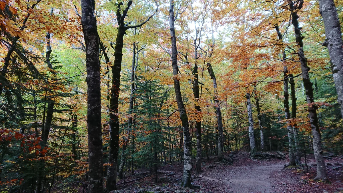
An earth path curves among tall trees with green, yellow and orange foliage in the Ordesa valley.

Autumn woodland in the Ordesa valley, photographed in October 2018. This wider valley view illustrates the forest setting rather than a specific section of the Pradera accessible path.

Forest inside Ordesa Valley, Ordesa y Monte Perdido National Park, Spain.jpg — Heparina1985 / Wikimedia Commons / CC BY-SA 4.0 · Creative Commons

Walks and routes

Pradera adapted path: the gentle introduction

From the signed adapted-path start at the eastern end of the Pradera car park, follow the marked route alongside the Arazas, across the river and into woodland. Continue only as far as suits your group, then return the same way. The full path reaches a resting area facing the Cotatuero cirque. The documented length is 1.2 km each way, about 2.4 km for the return trip, plus the approach from the shuttle stop; the route sources list 30 m of elevation change. Allow 1¼–2 hours with pauses. Stay with the adapted-path signs where longer routes branch away.

COCEMFE Aragón describes earth-and-concrete surfacing, rest areas and some pavement deterioration. Ask about the section’s current condition before setting out; wet leaves, ice and damaged surfaces can change what is manageable.


Lower waterfalls: a separate longer choice

Choose this instead of the short adapted outing if everyone is comfortable with a longer walk. The official Pradera–Cascadas del Estrecho route follows the Soaso path through beech and fir woodland to the Arripas area and the Cueva and Estrecho waterfalls. It describes a signed return across the Arazas on the other bank. Ask staff which sections are open and follow the marked route rather than improvising a river crossing. The park gives one hour outward and 100 m of elevation change; allow around 2½–3½ hours overall with stops.

This is an ordinary walking trail with uneven ground and viewpoint approaches. It is not the adapted path; do not assume it suits a wheelchair or pushchair.

Lower waterfalls: a separate longer choice

A relaxed first visit

Spend 30–60 minutes getting your bearings at the Torla visitor centre when it is open. Travel to the Pradera, confirm your return arrangements and choose a turnaround time. Walk a suitable part of the adapted path, pausing for one view, one tree and one sound. Leave time for a snack and an unhurried return. On a busy shuttle day, the queue may be the slowest part of the plan.

For another day

Cola de Caballo is a substantial out-and-back; the Cazadores–Faja de Pelay circuit is a mountain route that the park lists at seven hours and 650 m of elevation change. Monte Perdido and Góriz require their own preparation. Walking up from Torla by Turieto Bajo also changes the day: the official estimate is two hours one way and 300 m of elevation change before your Pradera visit begins.

Things to try

Read the valley

Find a safe place to stop and trace the big shape of the valley with your eyes. Which surfaces are sheer rock, which carry trees, and where does water emerge? Try a quick sketch of the skyline. It is a simple way to notice how differently ice, flowing water and vegetation have marked the same landscape.

Build a woodland colour chart

Look for several shades in the canopy and on leaves already on the ground. Photograph or draw them without collecting anything. Compare a broadleaf branch with a conifer from the path, and use the interpretation panels or ask staff to help identify what you see.

Listen before looking

Spend a quiet minute on a safe, roomy part of the path. Separate river noise, wind in the leaves and bird calls. If something moves, let it come into view rather than following it off the path. Binoculars are useful only after you have stopped somewhere secure.

Make Torla the destination

If the mountain forecast is poor, use the Torla visitor centre’s geology, nature and mountain-culture displays as the main visit, subject to opening. A quiet hour indoors is better than pressing on into heavy rain, strong wind or unsafe ground. Do not assume woodland gives protection from falling branches or stones.

Wildlife and habitats

European beech

Beech is part of the park’s wild beech–fir woodland, including the woods described on the lower-waterfall route. Compare broad leaves and the canopy from the path.

Silver fir

Silver fir shares woodland with beech in Ordesa. Look for the contrast between evergreen branches and broadleaf trees without leaving the trail.

Scots pine

Scots pine occurs in the park’s montane woodland. It is another tree to learn on a visit, though this guide does not mark individual trees on the adapted path.

White-throated dipper

The park’s fauna list includes this river bird. From a safe place on an established path, scan exposed rocks and the moving water; stay out of the riverbed.

Black woodpecker

The official woodland account includes black woodpecker. Quiet pauses may reveal woodland bird activity; ask staff about identification rather than searching for nests.

Griffon vulture

Griffon vulture is listed among the park’s cliff-associated birds. From a safe open viewpoint, look high above the valley and use binoculars without approaching cliff edges.

These species belong to the park’s documented wildlife and woodland, but a short visit will not reveal them all. Watch from the paths, keep your distance and let the animals choose whether to appear. No call playback, baiting or nest-searching is needed for a rewarding visit.

Stories and discoveries

A landscape that moves water in two ways

Rain and snowmelt can disappear into cracks in the upper limestone, while down in the valleys water gathers into rivers and waterfalls. The Arazas is part of a mountain water system whose flow changes with snowmelt and rain.

Forest is part of the mountain story

Ordesa’s woodland includes beech–fir communities as well as Scots pine. Looking at the trees is a worthwhile destination in itself, rather than simply the stretch to get through on the way to higher ground.

The bucardo belongs to the park’s history

Torla’s visitor centre has a room devoted to the bucardo, the Pyrenean ibex whose last animals lived in the Ordesa valley. Treat this as a conservation story to explore indoors, not an animal to search for on today’s walk.

When to visit

Spring

Snowmelt makes water a compelling subject, but residual snow, ice and unstable weather can restrict walking. Ask about the valley path itself, not just whether the road is open.

Summer

Start with a suitable forecast and enough water. Avoid extending the walk into worsening thunderstorm weather, and remember that shuttle queues can take a sizeable part of the day.

Autumn and winter

Autumn colour is a reason to slow down, while damp leaves and less daylight are reasons to shorten the route. In winter, snow, ice and avalanche danger can change the outing completely; choose a centre visit if the walking conditions are unsuitable.

Getting there and practical advice

Torla visitor centre

The centre on Avenida de Ordesa has mountain displays, a projection room and visitor information. Telephone +34 974 486 472 for opening and access questions. Allow time to ask about the day’s paths before committing to the journey up the valley.

Pradera information and refreshments

The Pradera has a visitor information point and a café-restaurant near the arrival area. Opening depends on the season; bring your own water and a snack rather than making the outing depend on a purchase. COCEMFE Aragón lists adapted toilets near the restaurant; confirm availability with staff.

October 2026 opening window

The park’s sheet valid through 24 October 2026 lists Torla’s visitor centre from 28 September to 24 October at 09:00–14:00 and 16:15–19:00. The Pradera information point is listed at 09:00–17:00 for 1–24 October. Hours may change; for later dates, check the replacement calendar.

Shuttle and private cars

The shuttle leaves the car park beside the Torla visitor centre and runs to the Pradera. Its published 2026 operating periods are 1–6 April, 1–3 May, 19 June–20 September, 25–27 September, 2–18 October, 23–25 October and 30 October–2 November. On operating days, ordinary private-car access is restricted. Outside those periods, access remains subject to parking capacity, road conditions and any other controls. Extra shuttle dates may be added.

Tickets, queues and the return

Prices checked on 16 October 2026 were €6 return or €4 one way for the standard ticket. The operator lists a free return ticket for children under 10 and a €5 return concession for over-65s and disabled passengers, with the required proof. Tickets are open rather than timed reservations; the Torla car-park ticket office is the simplest purchase point. The valley limit is 1,800 people at once, and uphill services can pause when it is reached. The operator’s webpage and PDF differ on some final returns: confirm the day’s time at the ticket office and aim for an earlier bus.

Arriving without a car

Arrange your journey to Torla and your onward connection separately from the park shuttle. Walking from Torla is a proper additional hike, not a quick way around a full bus queue. The Torla car park is listed as free, but overnight stays there are prohibited.

Plan the whole chain

Ask the visitor centre about reaching the trailhead, any suitable shuttle service and the procedure for a special vehicle permit if you hold a disability parking card. Do not assume that showing the card at the road barrier is enough. Allow for the distance between the bus stop and the adapted-path start.

Torla building and individual facilities

COCEMFE Aragón describes access ramps, a ramped exhibition route and an adapted toilet in the Torla centre. Ask which facilities and sections are available for your visit, especially if you depend on a particular toilet, turning space or assistance arrangement.

Sources and useful links

Wildlife you might spot

5

Each card links to a full Explore page with photos, traits, and fun facts.

Snap map for this place

Start with the big picture, then zoom in to explore individual wildlife observations around this place.

Loading map…

Good to know before you go

Check the park notices, road conditions and AEMET’s mountain forecast before travelling, then ask staff about your chosen path.

On shuttle days, leave the car in Torla unless the park has issued a specific access authorisation. Confirm your return service at the ticket office.

Bring drinking water, food, grippy footwear, a warm layer and a waterproof. Keep a daylight margin even for a short walk.

At the Pradera, ask specifically for the adapted path. Several much longer routes start in the same area.

Keep children close beside water and at viewpoints. Stop on a safe part of the path before taking photographs or using binoculars.

Stay on authorised paths; do not pick plants, collect stones, feed wildlife or enter rivers. Swimming is prohibited.

Keep dogs on a lead and away from livestock. Check the shuttle’s carrier rules before bringing one.

Do not light fires or fly a drone. Take your rubbish back with you and leave the woods quiet for other visitors and wildlife.

Frequently asked questions

Torla-Ordesa is the gateway village outside the park. The visitor centre and shuttle departure are there; the Pradera de Ordesa is the valley trailhead reached afterwards.
Private-car access is restricted while the shuttle operates. Outside those periods it may be allowed until the car park fills, subject to road conditions and park controls. A disability parking card does not by itself replace any required park authorisation.
At the October 2026 check, OrdesaBus sells open tickets and states that advance seat reservations and online sales are unavailable. A ticket does not guarantee immediate boarding when the valley is at capacity. Check the operator again before travelling.
No. The park lists 2½–3 hours one way and 550 m of elevation change for that route. It needs a separate full-day plan, enough energy for the return and suitable mountain conditions.
Dogs must stay on a lead in the park. Ordinary pets travel in carriers in the shuttle’s luggage compartment, subject to space; the operator describes a cabin exception for identified guide dogs. Check arrangements directly if you travel with an assistance dog.
No. The Ordesa sector prohibits bivouacking and overnight camping except in the separately reserved camping area at Góriz. Góriz is a high-mountain destination, not accommodation beside this short walk.

Recent snaps at this place

View all ›

Take the discovery with you

Exploring Ordesa y Monte Perdido National Park?

Identify the wildlife you spot, learn as you go, and keep a collection of the adventure.

  1. 1Spot it
  2. 2Snap it
  3. 3Keep the discovery