


Eastern White Pine

This unique National Scenic Trail winds over 1,200 miles across Wisconsin, serving as a living classroom and breathtaking pathway carved by ancient glaciers.
This unique National Scenic Trail winds over 1,200 miles across Wisconsin, serving as a living classroom and breathtaking pathway carved by ancient glaciers. It's one of only 11 National Scenic Trails in the United States and the only one contained entirely within a single state, offering an unparalleled opportunity to explore the geological wonders of the last Ice Age. Hikers can traverse diverse landscapes, from dense forests to expansive prairies, all while tracing the terminal moraine left by the Laurentide Ice Sheet thousands of years ago.
The trail highlights numerous distinctive glacial features, including towering kames like Holy Hill, serpentine eskers such as the Parnell Esker, and the dramatic depressions of kettles. Visitors can witness the impressive Dalles of the St. Croix River, characterized by massive potholes carved by glacial meltwaters, and explore hummocky moraines and scattered glacial erratics (lone boulders) that tell a vivid story of immense ice sheets. Along its route, the trail also showcases restored prairies bursting with wildflowers like the vibrant Butterfly Milkweed and the navigational Compass Plant, alongside rich oak savannas and diverse wetlands.
A hike on the Ice Age Trail offers more than just exercise; it’s an immersive experience that connects you deeply with nature and a profound geological history. Whether seeking a peaceful stroll through a vibrant oak savanna, a challenging trek over rugged terrain, or an educational exploration of glacial landforms, the trail provides a memorable adventure. It's an ideal destination for those looking to witness Wisconsin's natural beauty, observe wildlife like white-tailed deer and various bird species, and reflect on the powerful forces that shaped our world. Enhance your adventure: download the Snappit app to identify the local species you encounter.
The concept for the Ice Age Trail originated in the 1950s with conservationist Ray Zillmer, who envisioned an "Ice Age National Park" spanning 500 miles to preserve and interpret Wisconsin's unique glacial features like kames, drumlins, and kettle moraines. In 1958, Zillmer founded the Ice Age Park & Trail Foundation (now the Ice Age Trail Alliance), a non-profit, volunteer-based organization dedicated to creating and maintaining the trail. The trail gained national recognition in 1980 when Congress officially designated it as a National Scenic Trail, largely due to the efforts of U.S. Representative Henry Reuss. Today, the trail is a cooperative effort between the National Park Service, the Wisconsin Department of Natural Resources, and the Ice Age Trail Alliance, working together to develop, maintain, and protect this significant natural resource.
Activities include hiking, backpacking, wildlife viewing (white-tailed deer, various bird species), and birdwatching. In winter, certain sections are suitable for cross-country skiing and snowshoeing. Educational and interpretive centers, particularly within the Ice Age Scientific Reserve units like Interstate State Park and Kettle Moraine Forest, offer insights into glacial history.
Spring: Expect beautiful wildflowers, but be prepared for potentially muddy conditions and increased tick activity.
Summer: Can be hot and humid, with a high presence of mosquitoes and other biting insects. Bug nets are recommended.
Fall: Generally considered the best season, offering comfortable temperatures, vibrant fall colors, and fewer bugs.
Winter: Opportunities for snowshoeing and cross-country skiing on suitable segments. Dress warmly and be prepared for snow and ice.
Hunting Seasons: The trail passes through hunting lands. Hikers should be aware of state hunting seasons and wear blaze orange for safety, especially in fall and early spring.
While much of the trail is off-road and natural, some segments, particularly in urban areas like Portage, Verona, Slinger, Hartland, and Lodi, are paved and offer greater accessibility for strollers and wheelchairs.
Explore the remarkable glacial landforms such as the towering **kames** found at Holy Hill, the long, winding **eskers** like the Parnell Esker, and the numerous **kettles** (depressions, often filled with water) scattered across the landscape. Specific scenic areas include the dramatic **bluffs of Devil's Lake State Park**, the water-scoured **Dalles of the St. Croix River**, and segments that traverse restored **prairies** rich with native wildflowers.
Each card links to a full Explore page with photos, traits, and fun facts.
Start with the big picture, then zoom in to explore individual wildlife observations around this place.
Plan Ahead
** Always check the Ice Age Trail Alliance website or use the Ice Age Trail Atlas and Guidebook for up-to-date maps, segment information, and current conditions before embarking on your hike. The Guthooks app is also a useful resource.
Dress Appropriately
Wear sturdy hiking boots or shoes, and layer clothing, especially in spring and fall, to adapt to changing weather conditions.
Bug Protection
If hiking in summer, bring strong insect repellent and consider a bug net, as mosquitoes and other biting insects can be prolific.
Carry Water
Ensure you carry enough water, especially on longer segments, as water sources may be limited in some areas.
Stay Safe During Hunting Seasons
If hiking during hunting seasons (typically fall and early spring), wear blaze orange clothing to be visible to hunters. Check local regulations.
Utilize Trail Angels
For longer treks, connect with the Ice Age Trail Alliance to learn about "Trail Angels" who can provide assistance with shuttles, lodging, or resupply.
Jun 4, 2026
Photo attribution
(c) Mike B, some rights reserved (CC BY-SA)
License: CC BY-SA 4.0 ↗
Image may be shown cropped inside the card frame.
Jun 4, 2026
Photo attribution
(c) Mike B, some rights reserved (CC BY-SA)
License: CC BY-SA 4.0 ↗
Image may be shown cropped inside the card frame.
Jun 4, 2026
Photo attribution
(c) Mike B, some rights reserved (CC BY-SA)
License: CC BY-SA 4.0 ↗
Image may be shown cropped inside the card frame.
Jun 18, 2026
Jun 18, 2026

Maryland, US
You might spot White-Tailed Deer and Eastern Gray Squirrel.
View guide →
.jpg)
District of Columbia, US
You might spot Eastern Gray Squirrel, Duck, and House Sparrow.
View guide →

Illinois, US
You might spot American Robin, Canada Goose, and House Sparrow.
View guide →
Virginia, US
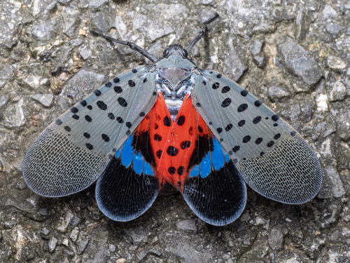
You might spot Spotted Lanternfly and Northern Cardinal.
View guide →


_(10171293746).jpg&width=800)