


Western Fence Lizard
The Iron Horse Regional Trail is a vital artery for recreation and transportation, weaving through the scenic East Bay region of California.
The Iron Horse Regional Trail is a vital artery for recreation and transportation, weaving through the scenic East Bay region of California. This 32-mile paved pathway, built on a historic railroad corridor, connects nine vibrant communities and offers a unique blend of urban accessibility and natural beauty. It's a cherished resource for thousands, providing a safe and enjoyable route for various outdoor activities.
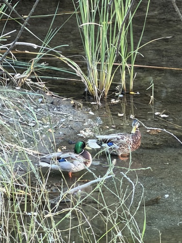
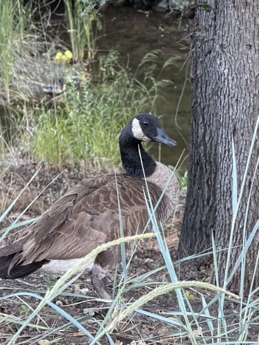
As you traverse the trail, you'll encounter diverse landscapes, from the marshy creeks near Concord, where ducks, geese, and egrets can often be spotted, to shaded sections lined with mature Oak trees in Alamo and Danville. The trail seamlessly links parks, business centers, and residential areas, featuring points of interest like the restored Southern Pacific Depot in Danville, which now houses the Museum of the San Ramon Valley. Public art installations and historic markers also dot the route, adding cultural and educational stops to your journey.
More than just a path, the Iron Horse Regional Trail is a community connector and a gateway to the East Bay's charm. Its flat, well-maintained surface makes it accessible for all ages and abilities, offering a refreshing escape into nature or a convenient route for daily commutes. Whether you're seeking a leisurely stroll, an invigorating bike ride, or a historical exploration, this trail provides a memorable experience that showcases the region's rich heritage and natural allure. Explore the grounds like a pro—download the Snappit app to instantly identify animals and plants.
The Iron Horse Regional Trail follows the historic right-of-way of the Southern Pacific Railroad's San Ramon Branch Line, which was established in 1891. This railway played a crucial role in the development of central Contra Costa County, facilitating the transport of agricultural products and connecting communities. Passenger service eventually ceased in 1934, and by the late 1970s, the line fell into disuse and was abandoned by Southern Pacific in 1977. Recognizing its potential as a transportation corridor, Alameda and Contra Costa Counties purchased the right-of-way between 1983 and 1989. The East Bay Regional Park District had already identified the route as a priority for a future trail in its 1976 Master Plan. Through the combined efforts of local community groups, such as the Right of Way Trail Advocates, and government agencies, the Iron Horse Trail was first established in 1986. Over the years, the trail has been incrementally extended and improved, with significant segments opening in 2008 and 2014, and plans to eventually span over 50 miles, connecting 12 cities from Livermore to Suisun Bay.
Biking: The paved, mostly flat trail is ideal for cyclists of all levels.
* **Walking/Running: ** Enjoy a leisurely stroll, power walk, or run through diverse urban and natural settings.
* **Horseback Riding: ** Equestrian access is available in certain areas; contact the East Bay Regional Park District for details.
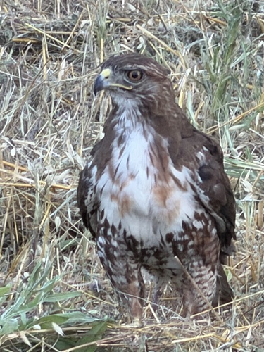
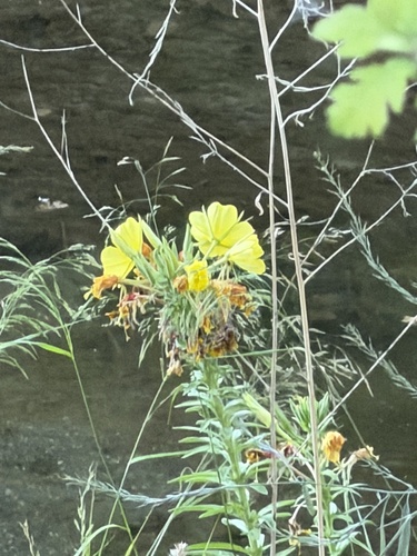
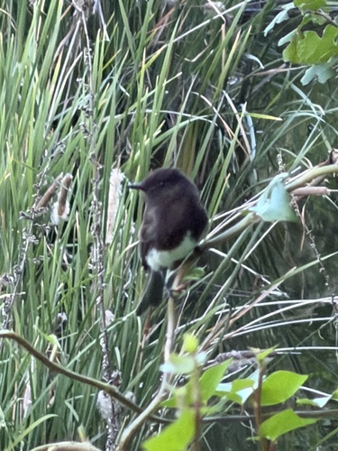
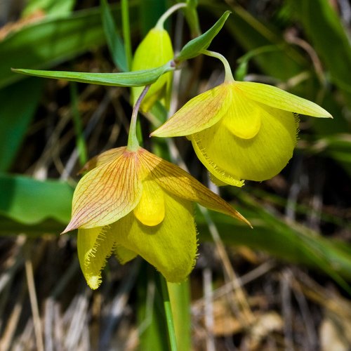
* **Wildlife Viewing: ** Keep an eye out for birds, small mammals, and wildflowers, particularly in less urbanized sections and near Walnut Creek.
* **Connect to BART: ** The trail connects directly to the Dublin/Pleasanton and Pleasant Hill BART stations, making it accessible via public transport.
Spring: Ideal for wildflowers and birdwatching.
Summer: Can be hot; carry plenty of water and seek shaded sections. Rattlesnakes might be sunning themselves on warmer days.
Fall: Pleasant temperatures for all activities.
Winter: Offers green landscapes, especially after rains.
The entire route is paved, well-maintained, and wheelchair accessible. Adjacent unpaved or soft trails are available in certain areas. The trail features several bridges over busy roads to ensure smooth passage.
Enjoy views of Walnut Creek, offering opportunities to spot ducks, geese, and egrets.
Explore the charming downtown area, including the restored Southern Pacific Depot (circa 1891), which now houses the Museum of the San Ramon Valley. Shaded sections provide a pleasant experience.
Discover public art installations and markers detailing the trail's railroad history.
Several pedestrian and bicycle bridges, such as those over Treat Boulevard and Ygnacio Valley Road, offer scenic vantage points and improve traffic flow.
Each card links to a full Explore page with photos, traits, and fun facts.
Start with the big picture, then zoom in to explore individual wildlife observations around this place.
Hydrate and Plan Ahead
Especially on warmer days, carry plenty of water. Check a trail map beforehand to plan your route, identify staging areas, and note amenities like restrooms or dining options in nearby downtowns.
Practice Trail Etiquette
The Iron Horse Trail is multi-use. Cyclists must yield to both pedestrians and horses, and pedestrians should yield to horses. Slow down, ring a bell, and make verbal contact when passing.
Explore Downtown Danville
Make a stop in downtown Danville to visit the Museum of the San Ramon Valley, located in the historic Southern Pacific Depot, and enjoy the local shops and restaurants.
Consider BART for One-Way Trips
Utilize the trail's direct connections to Dublin/Pleasanton and Pleasant Hill BART stations for convenient one-way rides or to access different segments of the trail.
Be Aware of Natural Hazards
During warmer months, be mindful of potential rattlesnakes sunning themselves and be aware of poison oak, stinging nettles, and ticks in vegetated areas. Wear appropriate clothing.
Seek Shade
Some sections, particularly through Alamo and Danville, offer shade from mature oak trees, providing welcome relief on sunny days.
Jun 6, 2026
Photo attribution
(c) Irina Mitine, some rights reserved (CC BY)
License: CC BY 4.0 ↗
Image may be shown cropped inside the card frame.
Jun 6, 2026
Photo attribution
(c) Irina Mitine, some rights reserved (CC BY)
License: CC BY 4.0 ↗
Image may be shown cropped inside the card frame.
Jun 6, 2026
Photo attribution
(c) Irina Mitine, some rights reserved (CC BY)
License: CC BY 4.0 ↗
Image may be shown cropped inside the card frame.
Jun 6, 2026
Photo attribution
(c) Irina Mitine, some rights reserved (CC BY)
License: CC BY 4.0 ↗
Image may be shown cropped inside the card frame.
Jun 6, 2026
Photo attribution
(c) Irina Mitine, some rights reserved (CC BY)
License: CC BY 4.0 ↗
Image may be shown cropped inside the card frame.

Maryland, US
You might spot White-Tailed Deer and Eastern Gray Squirrel.
View guide →
.jpg)
District of Columbia, US
You might spot Eastern Gray Squirrel, Duck, and House Sparrow.
View guide →

Illinois, US
You might spot American Robin, Canada Goose, and House Sparrow.
View guide →
Virginia, US
You might spot Spotted Lanternfly and Northern Cardinal.
View guide →