


Banana Slug

Arcata Community Forest offers a unique blend of majestic redwoods and diverse recreational opportunities.
Arcata Community Forest offers a unique blend of majestic redwoods and diverse recreational opportunities. This treasured municipal forest, spanning approximately 2,350 acres, is a remarkable example of sustainable forestry, nestled right on the eastern edge of Arcata, California. As the first municipal forest in California and the first in the U.S. to be certified under the Forest Stewardship Council, it expertly balances recreation, watershed protection, wildlife habitat, and responsible timber harvesting, generating revenue to support its own upkeep and other city parks.
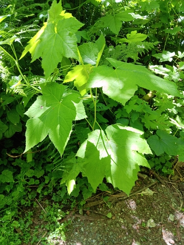
Visitors can explore an extensive network of trails perfect for hiking, mountain biking, and horseback riding, winding through lush second-growth redwood groves, alongside pristine creeks like Janes Creek, Jolly Giant Creek, and Gannon Creek. The forest is a haven for biodiversity, home to over 140 bird species and rare plants such as the California lady's slipper orchid. Keep an eye out for diverse flora, from vibrant Western Sword Ferns carpeting the forest floor to the striking Big Leaf Maples that offer stunning autumn colors.
A visit to the Arcata Community Forest provides an immediate escape into the tranquility of nature, offering a profound sense of peace just moments from the city center. Whether you're seeking an invigorating outdoor adventure, a serene spot for wildlife observation, or simply a breathtaking walk under towering redwoods, this living laboratory of sustainable land management promises a memorable and enriching experience for all. Its innovative approach to community-managed natural resources makes it a truly special destination. Take the ultimate field guide with you: use the Snappit app to identify birds, plants, and animals on your trip.
The history of the Arcata Community Forest predates European settlement, with the land traditionally occupied by the indigenous Wiyot people, who utilized its resources for hunting and fishing. Following European settlement in the mid-19th century, the area underwent significant logging and was subsequently used for grazing. The modern era of the forest began in the 1930s-1940s when the City of Arcata acquired title to the land, initially for water supply purposes. On May 17, 1955, it was formally dedicated as the first municipally-owned forest in California, intended for "the benefit of all citizens of the city, with attention to watershed, recreation, timber management, and other values." A pivotal moment occurred in 1979 when Arcata citizens passed the "Forest Management and Parkland Initiative," leading to its certification as the first municipal forest in the U.S. under the Forest Stewardship Council, solidifying its commitment to sustainable management. Over the years, the forest has expanded, notably with the addition of the 171-acre Sunny Brae Forest in 2006 and further acquisitions for the Jacoby Creek Forest, demonstrating continued growth and dedication to preserving this vital natural space.
Hike or bike beneath towering redwoods, go birdwatching to spot some of the 140+ species, explore the diverse plant life including ferns and native shrubs, or enjoy a picnic. Horseback riding is also a popular activity on designated trails.
Fall can be particularly scenic with changing foliage and often clearer views. Rainfall can affect creek levels, making stream crossings and trail conditions vary.
While many trails are packed dirt and can be uneven, making them not fully ADA accessible, areas around Redwood Park are generally more accessible with paved sections and facilities. ADA parking is available near the Jolly Giant Commons. Trail maps indicate different terrain types.
Over 20 miles of trails for hiking, mountain biking, and horseback riding.
Adjacent to the forest, offering easy access, picnic areas, a playground, and restrooms.
Explore picturesque valleys along this and other creeks like Jolly Giant and Gannon.
A significant 4.5-mile regional trail linking different parts of Arcata.
Each card links to a full Explore page with photos, traits, and fun facts.
Start with the big picture, then zoom in to explore individual wildlife observations around this place.
Consult Trail Maps
** Pick up a free trail map at parking lots or download a PDF version from the City of Arcata website to navigate the extensive network and choose trails suitable for your activity level.
Leash Your Dog
If visiting with a canine companion, ensure they are on a leash at all times, as required by city law, and carry bags to clean up after them.
Share the Trails
Be mindful of other users, as trails are multi-use for hikers, mountain bikers, and equestrians. Announce yourself when passing.
Wear Appropriate Footwear
Many trails are packed dirt and can be uneven or muddy, especially after rain, so sturdy hiking shoes are recommended.
Check Conditions
Before visiting, especially after heavy rains, check the City of Arcata website for any trail closures or advisories, as some trails may become very wet.
Parking
While parking is free, it can be limited at main trailheads. Consider walking or biking to the forest if you are staying nearby.

Maryland, US
You might spot White-Tailed Deer and Eastern Gray Squirrel.
View guide →
.jpg)
District of Columbia, US
You might spot Eastern Gray Squirrel, Duck, and House Sparrow.
View guide →

Illinois, US
You might spot American Robin, Canada Goose, and House Sparrow.
View guide →
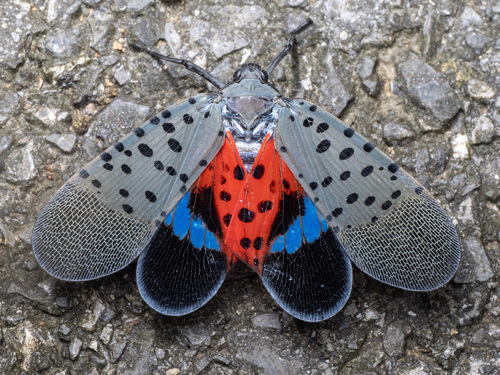
Virginia, US
You might spot Spotted Lanternfly and Northern Cardinal.
View guide →