


Great Horned Owl

Step back in time to an era of immense geological power, where a colossal ice-dammed lake shaped the very landscape of western Montana.
Step back in time to an era of immense geological power, where a colossal ice-dammed lake shaped the very landscape of western Montana. "Lake Missoula," more accurately known as Glacial Lake Missoula, refers to the remnants and features left behind by one of Earth's most cataclysmic prehistoric events. This isn't a single traditional park, but rather a vast outdoor museum spread across the region, where the monumental scale of ancient ice age floods comes vividly to life through breathtaking geological formations, interpretive sites, and engaging educational exhibits. From towering ripple marks to ancient shorelines etched into mountainsides, visitors can explore the dramatic evidence of a lake that was once deeper than the Empire State Building is tall.
The narrative of Glacial Lake Missoula unfolds across key sites within the Ice Age Floods National Geologic Trail. Witness the astounding Camas Prairie Giant Ripples near Hot Springs, immense gravel waves reaching up to 50 feet high and a half-mile long, testaments to the incredible force of water that once roared through these valleys. In Missoula, the distinct Glacial Lake Missoula Strandlines, visible as parallel benches on Mount Sentinel and Mount Jumbo, reveal the various ancient water levels. Interpretive centers like the Montana Natural History Center offer immersive displays and interactive exhibits, bringing to life the geological processes and the local flora and fauna that now thrive in these uniquely shaped environments.
Exploring these sites offers an unparalleled opportunity to connect with Earth's dynamic past and marvel at the enduring power of nature. It's a journey of discovery, where every vista tells a story of ice, water, and monumental change. The experience provides a deep appreciation for the geological forces that sculpted the region, complemented by the chance to observe the diverse ecosystems that have reclaimed these ancient floodways, making it a truly memorable destination for anyone fascinated by natural history and stunning landscapes. Enhance your adventure: download the Snappit app to identify the local species you encounter.
Glacial Lake Missoula existed at the end of the last Ice Age, roughly 15,000 to 13,000 years ago. During this period, a lobe of the Cordilleran Ice Sheet advanced southward into northern Idaho, forming a massive ice dam across the Clark Fork River. This dam created an enormous lake, Glacial Lake Missoula, which covered about 3,000 square miles of western Montana, held over 500 cubic miles of water, and reached depths of up to 2,000 feet. The ice dam, however, was not permanent. As the lake waters rose, pressure on the ice dam increased until it catastrophically failed, unleashing floods of unimaginable scale (known as the Missoula Floods) that surged across northern Idaho, eastern Washington, and down the Columbia River Gorge to the Pacific Ocean. This cycle of filling and emptying repeated dozens of times over approximately 2,500 years, with some estimates suggesting up to 100 or more flood events. The erosive power of these floods sculpted the landscape, leaving behind the distinctive features seen today, which continue to be studied and interpreted by geologists and the Ice Age Floods National Geologic Trail.
Hike or drive to scenic overlooks to view geological formations like the giant ripples and strandlines.
* Visit interpretive centers to learn about the science and history of the floods.
* Explore areas along the Clark Fork River, which was the primary drainage path for the lake, for both its geological features and opportunities for wildlife viewing and recreation.
* Look for historical markers and informational panels along the Ice Age Floods National Geologic Trail.
Spring: Wildflowers bloom, and river levels are often higher, offering dynamic views of the Clark Fork River. Some higher-elevation trails might still have snow.
Summer: Warmest temperatures, ideal for hiking and outdoor activities. Popular sites can be crowded.
Fall: Cooler temperatures and stunning autumn colors from deciduous trees like Western Larch. Excellent for photography and hiking.
Winter: Snow cover enhances the visibility of strandlines. Some roads and interpretive sites may have limited access or hours.
Many key viewing areas along main roads are accessible. The Montana Natural History Center and Paradise Center are generally accessible, with exhibits designed for a broad audience. Hiking trails like those on Mount Sentinel through the strandlines can be steep. Specific accessibility details should be checked for individual sites within the broader Glacial Lake Missoula region.
Witness the largest known giant current ripples on Earth.
Observe the ancient shorelines etched into Mount Sentinel and Mount Jumbo in Missoula.
Explore interactive exhibits on Glacial Lake Missoula, local ecology, and wildlife.
View a detailed interactive 3D topographic relief map of Glacial Lake Missoula.
Each card links to a full Explore page with photos, traits, and fun facts.


Start with the big picture, then zoom in to explore individual wildlife observations around this place.
Plan a driving tour
The evidence of Glacial Lake Missoula is spread across a large area. Utilize resources like the Ice Age Floods National Geologic Trail maps to plan a route connecting key sites.
Visit interpretive centers first
Start your journey at the Montana Natural History Center in Missoula or the Paradise Center to gain a foundational understanding of the floods before exploring outdoor sites.
Wear appropriate footwear
Many sites involve walking on uneven terrain or hiking trails. Sturdy hiking shoes are recommended.
Bring water and snacks
Especially for longer drives and hikes, ensure you have sufficient provisions, as services might be sparse between locations.
Utilize viewpoints
Look for designated pull-offs and scenic overlooks to fully appreciate the scale of features like the Camas Prairie Ripples and Hellgate Canyon.
Look for high-water markers
Keep an eye out for high-water markers and interpretive signs that pinpoint key geological features and explain their significance.
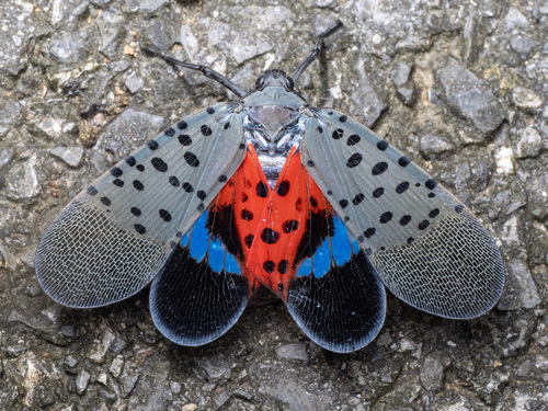
Jun 4, 2026
Photo attribution
(c) Taryn Brahmsteadt, some rights reserved (CC BY)
License: CC BY 4.0 ↗
Image may be shown cropped inside the card frame.
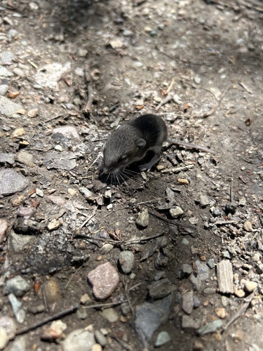
Jun 3, 2026
Photo attribution
(c) Taryn Brahmsteadt, some rights reserved (CC BY)
License: CC BY 4.0 ↗
Image may be shown cropped inside the card frame.
Jun 17, 2026
Jun 17, 2026
Jun 16, 2026

Maryland, US
You might spot White-Tailed Deer and Eastern Gray Squirrel.
View guide →
.jpg)
District of Columbia, US
You might spot Eastern Gray Squirrel, Duck, and House Sparrow.
View guide →

Illinois, US
You might spot American Robin, Canada Goose, and House Sparrow.
View guide →
Virginia, US
You might spot Spotted Lanternfly and Northern Cardinal.
View guide →
.jpg&width=800)